|
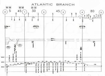
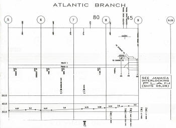
ATLANTIC BRANCH
|
|
ATLANTIC DIVISION |
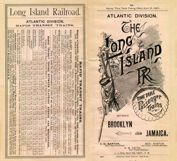
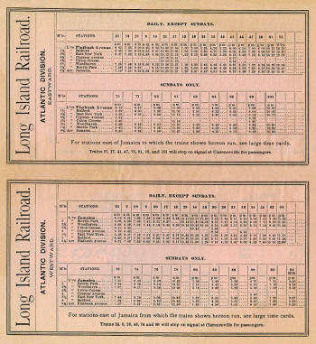
Timetable - Atlantic Division 4/10/1887
Archive: Jeff Erlitz |
 |
|
 |
 |
|
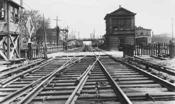
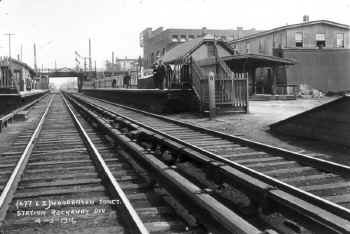
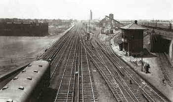
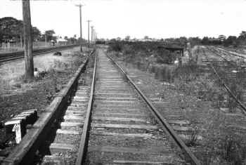
Atlantic Branch Track Profile maps 1994 - Flatbush Ave to DUNTON
Tower, Jamaica
|
|
|
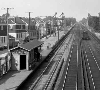
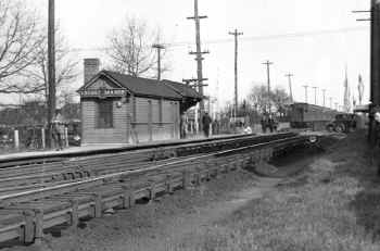
FLATBUSH
- (ATLANTIC TERMINAL) |
|
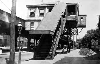
FLATBUSH STATION:
OLD DEPOT OPENED: ? RENOVATED: JULY-AUG/ 1878, RENOVATED AGAIN:
6/1880, REBUILT: 1893.
2ND DEPOT OPENED: 4/1/07 WITH DEPOT AT STREET LEVEL AND TRACKS
UNDERGROUND. REFURBISHED AND EXTERIOR SANDBLASTED: EARLY 1940s.
TRACK #1 OUT OF SVC: 4/10/59. FORMER EXPRESS TRACKS #s 9-14
("EX" YARD) OUT OF SVC: 3/3/71. TRACKS ORIGINALLY NUMBERED SOUTH TO NORTH
RENUMBERED NORTH TO SOUTH: 7/1/78. STREET LEVEL TERMINAL BLDG.
CLOSED: 1988. RAZED: c.1990's.
3RD DEPOT OPENED: 1/5/2010. OFFICIALLY RENAMED "ATLANTIC TERMINAL"
IN ETT #1, PER G.O. #104 EFF. 3/08/2010. Research: Dave Keller
|
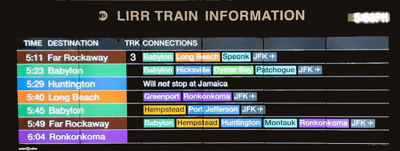
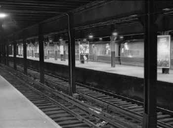
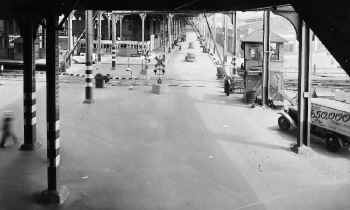
Atlantic Terminal - Departure Board 10/09/2022 Photo/Archive: Jeff
Erlitz |
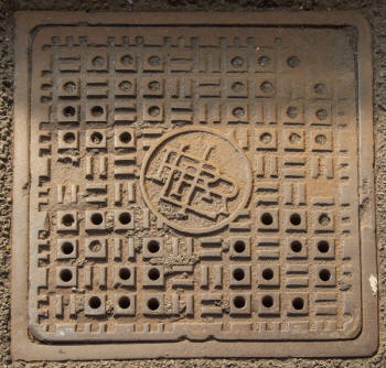
LIRR utility hole cover electrification east of
Nostrand Avenue Station c.1905
Photo/Archive: Jeff Erlitz |
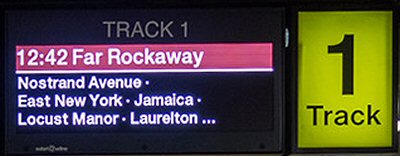
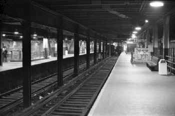
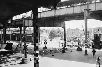
Atlantic Terminal Track 1 2/08/2023
Photo/Archive: Jeff Erlitz |
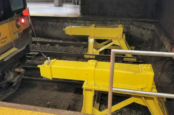
Brooklyn-Atlantic-Terminal-bumpers_11/22/2017
Source: The LIRR Today
The LIRR has installed new, stronger bumper posts on some
tracks at Brooklyn-Atlantic Terminal, after a Far Rockaway
train ran through the bumper block at the end of the station
on January 4, 2017, injuring more than 100 passengers.
These replace older and less resilient bumper posts.
|
|
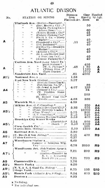
LIRR CR4 page 49 - Atlantic Division 3/01/1913
|

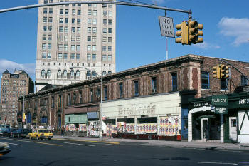
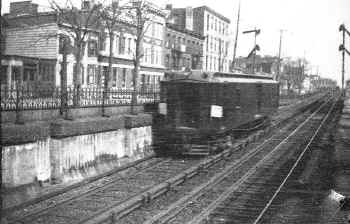
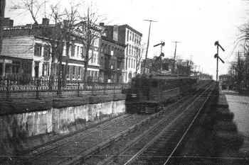
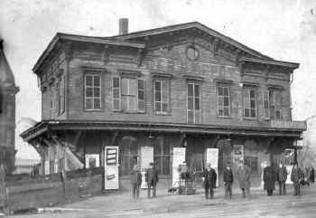
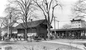
Flatbush Station Atlantic Ave., Brooklyn 1910
Archive: Rudolph Schubert 
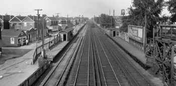
Flatbush Ave Station
06/1978 Photo: Art Huneke
Archive: Dave Keller |
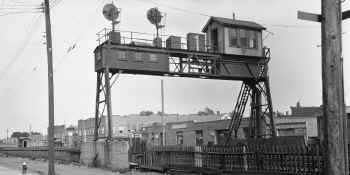
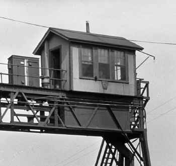
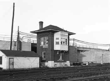
BROOK Tower 1:
Flatbush Ave Brooklyn 10/13/78 Madden-Keller
BROOK Tower 2: 11/3/2005
Archive: Jeff Erlitz
|
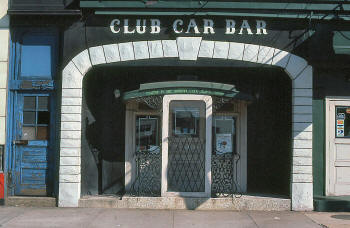
Flatbush Ave Station - Club Car Bar
4/1979 Photo/Archive: Bill Mangahas |
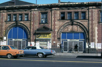
Flatbush Ave Station - 4/1979
Photo/Archive: Bill Mangahas |
Flatbush Ave Station facade
4/1979 Photo/Archive: Bill Mangahas |
|
FLATBUSH AVE:
OLD DEPOT RENOVATED: JULY-AUG/1878 RENOVATED AGAIN:
6/1880, REBUILT: 1893
2ND DEPOT OPENED: 4/01/1907 WITH DEPOT AT STREET LEVEL AND TRACKS
UNDERGROUND. REFURBISHED AND EXTERIOR SANDBLASTED: EARLY
1940s. TRACK #1 OUT OF SVC: 4/10/1959. FORMER EXPRESS TRACKS #s 9-14
("EX" YARD) OUT OF SVC: 3/03/1971. TRACKS
ORIGINALLY NUMBERED SOUTH TO NORTH RENUMBERED NORTH TO SOUTH:
7/1/78. STREET LEVEL TERMINAL BLDG.
CLOSED: 1988. RAZED: c. 1990's.
3RD
DEPOT OPENED: 1/05/2010. OFFICIALLY RENAMED "ATLANTIC TERMINAL"
IN ETT #1, PER G.O. #104 EFF. 3/08/2010.
Research: Dave Keller |
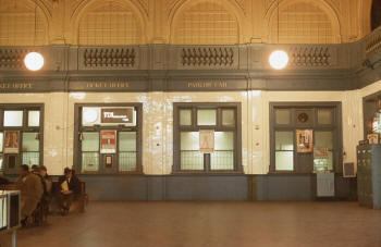
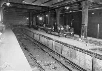
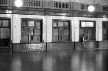
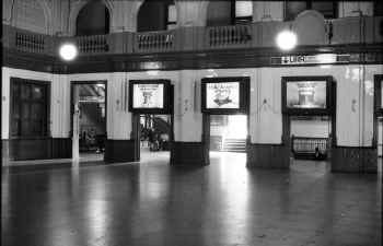
Flatbush Ave. Station
- Ticket Windows 1970 |
Flatbush Ave. Station
- Waiting Room 1979 (Huneke-Keller) |

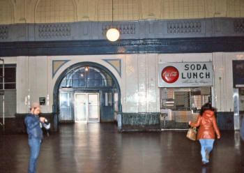
LIRR ticket office and train information booth at platform level
Flatbush Ave. Terminal, Brooklyn, NY - 1982
(Dave Keller archive) |
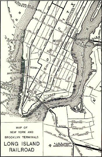
LIRR map of New York and Brooklyn Terminals 1900 |
H. Wilhelm Map - VD yard 7/31/1927
Ticket - Flatbush Ave. to Jamaica c.1929+ Archive: Brad Phillips
|
Flatbush 1908 map12 Merchandise Terminal-BRT
Flatbush 1908 map13 Passenger/Express coach yard
|
|
|
|

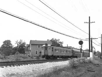
Train #2818 (Atlantic Terminal-Far Rockaway) comes out of the
Flatbush Avenue tunnel and approaches Nostrand Avenue station. M9
#9044 leads a short six-car train. The 23rd Regiment Armory, beyond
the train, was was built in 1891–95 and was designed in the
Romanesque Revival style by Fowler & Hough, local Brooklyn
architects, and Isaac Perry, the New York state government's
architect. View W 2/22/2023 Photo/Archive: Jeff Erlitz |
|
|
|
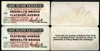
BROOKLYN BRIDGE SERVICE 1899 - 1904 |
This ticket was issued in connection with the Brooklyn Heights RR
(founded in 1860). The tickets are coupons from a commutation book.
Noted above, it appears that the LIRR connection to the bridge lasted 5 years, so the tickets probably date from this
period 1899-1904. Research: Brad Phillips |
 In
1899 an elevated structure was built to connect the LIRR with the
Brooklyn Union Elevated Railroad Company's Fifth Avenue EL. For five
years LIRR. rapid transit trains ran to Brooklyn Bridge where they
turned on a loop and returned to Jamaica, Far Rockaway, and Rockaway
Junction. For faster loading and unloading at Brooklyn Bridge the
railroad in 1898 and 1899 purchased 55 (?) center door trailers
opened by an employee on the station platform and were used only at
the bridge. Archive/Research: Art Huneke In
1899 an elevated structure was built to connect the LIRR with the
Brooklyn Union Elevated Railroad Company's Fifth Avenue EL. For five
years LIRR. rapid transit trains ran to Brooklyn Bridge where they
turned on a loop and returned to Jamaica, Far Rockaway, and Rockaway
Junction. For faster loading and unloading at Brooklyn Bridge the
railroad in 1898 and 1899 purchased 55 (?) center door trailers
opened by an employee on the station platform and were used only at
the bridge. Archive/Research: Art Huneke
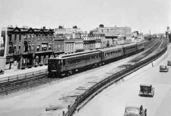
1899 EL construction ramps up and bridges the LIRR
tracks, connecting with the elevated BRT tracks running atop the
LIRR's Atlantic branch tracks.
The image above shows the LIRR's tracks at the far right, and the EL
structure elevated over Atlantic Ave., over the trolley tracks and
over the LIRR tracks, connecting with the BRT's tracks. Research:
Dave Keller
|
|
Return Ticket Brooklyn Bridge-Flatbush Ave 1894 allows passenger to
either take the “El” or use the ferry from Manhattan Island to
Brooklyn. Archive: Brad Phillips
Emery map Flatbush 4/1959 |
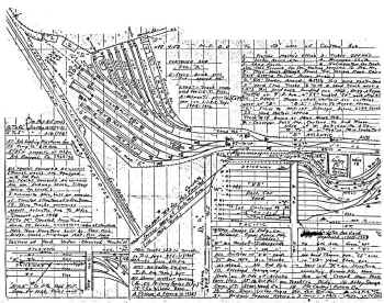
1899 EL map - View N Archive: Art Huneke |
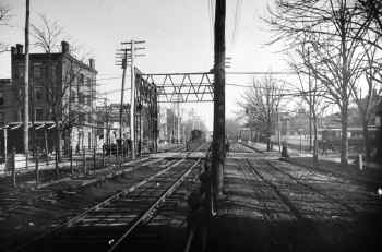
In this view W, Forney steam locomotive pulls an BRT EL
train eastbound along Atlantic Ave. In the distance is the 5th Ave.
EL connection, and the original LIRR Flatbush Avenue terminal
building is at the right. Passenger cars are visible at the open,
ground level platforms in this 1903 view. In 3 more years this
corner would look different as the new, LIRR brick terminal building
is put into service. (Dave Keller archive)
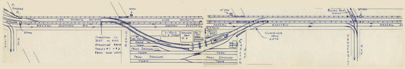
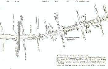
Here's what you're looking at, looking west towards Fifth Ave. c.
1903 from the elevated BRT connection indicated in the center of
your map. The old FBA terminal building is still in place with
open-air station platforms. You can see the many Nassau Elec. Ry.
trolleys:
The
map has to pre-date the 1906 demolition of the old terminal building
and construction of the "new" FBA terminal (which opened in 1907) as
the LIRR's tracks are all at-grade. Info: Dave Keller
|
1899 EL map stitched - View N Archive: Art Huneke
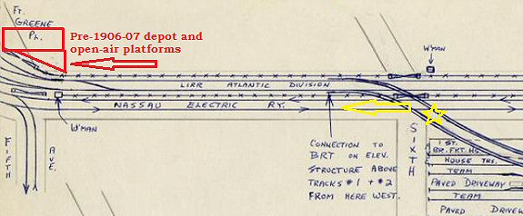
Red
rectangle and triangle at upper left is the pre 1906-07 "new" depot
with open-air, at-grade platforms. At this time, the BRT tracks are
elevated above the LIRR's Atlantic branch tracks. Also note the BRT connection in the center and the gates and grade
crossing beneath at Sixth Ave.
Nassau Electric RY was the trolley line running parallel to the LIRR
tracks and the BRT tracks were elevated above the Atlantic branch
tracks.
The EL tracks curve off at Fifth Ave. and the FBA terminal would be
on the north side of the Atlantic branch tracks. Note gates for
grade crossings at Fifth Ave!!!
|
|
|
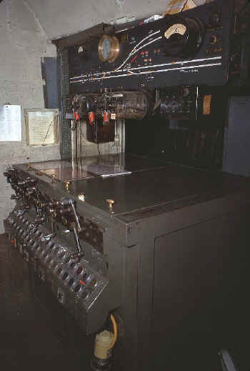
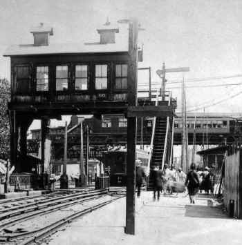
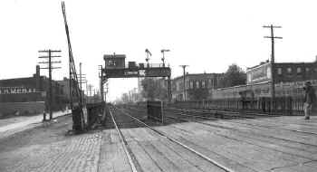
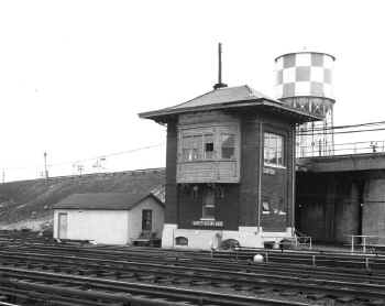
"BROOK" TOWER:1 FLATBUSH AVE., BROOKLYN (UNDERGROUND: E. END OF STATION PLATFORM BETWEEN TRACKS 4 AND 5. FORMERLY
"FT". 35-LEVER US&S MODEL 14 ELECTRO-PNEUMATIC MACHINE IN SVC: 1906. RENAMED: 4/15/37. OUT OF SVC: SUMMER/1999. Research: Dave Keller |
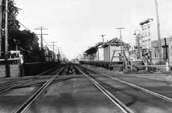
BROOK Interlocking 12/01/1954 |
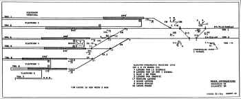
BROOK Interlocking 8/01/1996 Archive: Jeffrey Erlitz
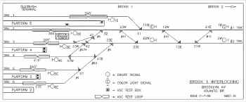
BROOK "1" Interlocking 11/07/1999
|
Atlantic Branch maximum speeds ETT
5/25/1970
ALL TRACKS FLATBUSH AVENUE STATION AND BROOK INTERLOCKING 5 MPH.
Note (1)
Between Brook and 1000 feet east of East New York: 45 MPH; EXCEPT
first curve east of Van to reverse curve east of Nostrand Avenue: 30
MPH.
1000 feet east of East New York to Dunton Tower: 80 MPH; Dunton and
Jay: 45 MPH.
Flatbush Avenue (Atlantic Terminal) Mile 0.0
Brook 0.1
Van 0.6
Nostrand Avenue 1.6
East New York 4.0
Woodhaven (closed) 7.2
Dunton 8.7
Jay 9.0 and Jamaica 9.3 Archive: Mike McEnaney |
|
|
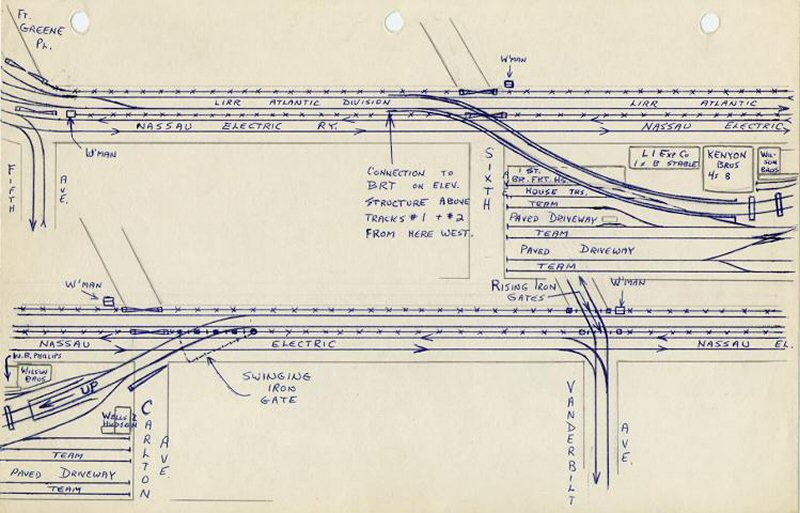
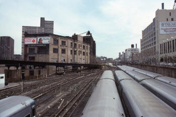
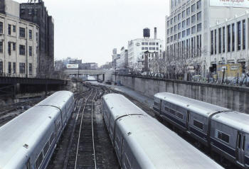
Vanderbilt Ave PASSENGER Yard |

Vanderbilt Ave Passenger Yard - MP54 Electrics at left along
Pacific St. view E from the 6th Ave. overpass and in the far
distance can be seen the overpass for Carleton Avenue. Beyond that overpass is the VD Team Yard. 6/1959
Photo/Archive: Art Huneke |
Vanderbilt Ave Passenger Yard - View E from the 6th Ave. overpass
and in the far
distance can be seen the overpass for Carleton Avenue.
Beyond that overpass is the VD Team Yard. c.1978 -
Photo: eBay |
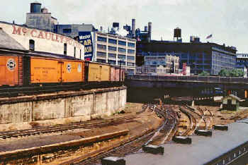
Vanderbilt Ave Yard - McCauley Potato Co. Warehouse
View E just west of the Carleton Avenue overpass. 6/1959
Photo/Archive: Art Huneke |
|
The elevated
tracks, (photos above) according to Emery's map, were for milk cars.
He said on the map that the tracks went across Atlantic Ave. before
1940 and connected with the merchandise terminal, to which his map
#789 reefers. The track curved
upward eastbound for the potato warehouse. (photo right) The
other track in front of it curved upward westbound for the elevated
milk platform indicated on Emery's map. Info: Dave Keller |
Vanderbilt Ave Yard, Brooklyn - Freight ramp at left
View E 1978 - Archive: Dave Keller |

VD yard Brooklyn 1987 - The M3's are there after the morning rush
waiting for the evening rush and possibly for light maintenance! -
Photo/Archive: MTA |
|
Van Tower Interlocking Machine - Vanderbilt Ave Yard
4/1978 Archive: Dave Keller |
VD Passenger Yard view SE 5/11/1979
(Madden-Keller)
VD Team Yard View east end of Yard
Brooklyn view SE 5/11/1979 (Madden-Keller)
|

Barclay's Center Brooklyn view SE c.6/2011
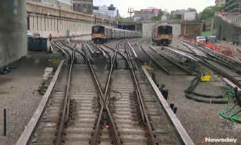
Atlantic Terminal - NEWSDAY 5/16/2018
|
|
This view is inside the block office that was built into the
concrete wall of the tunnel for trains to access "VD" yard.
Originally named "VD" tower, it was renamed "VAN" on 04/15/37. Data:
Dave Keller |
You can see the tunnel portal at the
far left of the yard which accessed the yard from the Atlantic
branch below the street and into which was built the subterranean
"VD" tower. The Barclay's Center is at the west end of the former VD
passenger yard. There is no yard under the Barclay's Center. The
center was constructed at the depressed grade of the former yard.
The former VD Passenger Yard EAST of 6th Ave. AND VD Team Yard at
the far left is to be covered over for new, multi high-rises of
"affordable housing" being constructed above it but it's not covered
over as of this time, from info I've received from Bob Myers. The
work is still in progress. It's called the "Atlantic Yards
Project."
Data: Dave Keller |

Flatbush 1908 map14 Merchandise Terminal
and Car Storage |
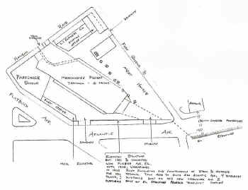
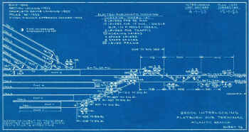
LIRR Flatbush Ave Merchandise Terminal drawing |

LIRR Flatbush Ave Track Plan drawing |
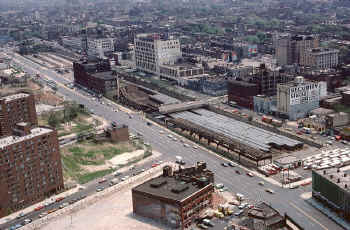
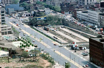
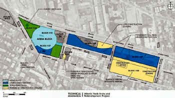
ATLANTIC YARDS
ARENA AND REDEVELOPMENT PROJECT 2010
 |
|
Flatbush Ave/
Atlantic Terminal and the new Barclay's Center - LIRR trains are now
being stored for service to and from Atlantic Terminal.
VD yard exists, but
is down to 5 tracks and a lead...one way in and out...one track. You
go in on a lead, which holds 10 cars...you go in west and then east
are brand new tracks 1,2,3,4...1 holds 6 cars, 2-4 hold 8 cars,
track 5, which is to the west and just north of the lead track holds
8, and the switching lead (which gets you to all tracks, holds 10).
For simplicity's sake of explaining it, the lead track and track No.
5 both end at bumper blocks at the basement wall to the new Barclay
Center.
|
In this view looking west a Forney steam locomotive pulls an EL
train eastbound along Atlantic Ave. In the distance is the 5th Ave.
EL connection, and the original LIRR Flatbush Avenue terminal
building is at the right. Passenger cars are visible at the open,
ground level platforms in this 1903 view. In 3 more years this
corner would look different as the new, LIRR brick terminal building
is put into service. (Dave Keller archive)
|
Station Flatbush Ave Brooklyn
tracks 1,2 7/17/1916 Keller |
Station Flatbush Ave Brooklyn Meat tracks 7/17/1916 Keller |
Station Flatbush Ave Brooklyn Ticket office at track level
06/1972 Archive: Dave Keller |

Station Flatbush Ave Brooklyn Gate Track 02/06/1978
(Huneke-Keller) |
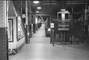
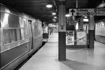
Track 6 gate and platform looking east from the subterranean
concourse. M1 train #1240 bound for Hempstead (with connection to
Babylon) is at the station awaiting to be boarded - 10-13-78 (Wm.
Madden photo, Dave Keller archive) |
Track 4 gate and platform looking east from the subterranean
concourse. M1 train #1211 bound for Far Rockaway (with connections
to West Hempstead, Babylon and Oyster Bay) is at the station
awaiting to be boarded. Visible at the right are the timetable
racks with the smaller, TDI timetables in the left rack and the
full-sized, branch timetables at the two right racks - 10-13-78 (Wm.
Madden photo, Dave Keller archive) |
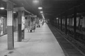
Track 2 looking west towards the bumpers and the subterranean
concourse - 10-13-78 (Wm. Madden photo, Dave Keller archive) |
View from track 2 looking southeast across to tracks 3 and 4
with an M1 train awaiting to be boarded on track 4 - 10-13-78 (Wm.
Madden photo, Dave Keller archive) |
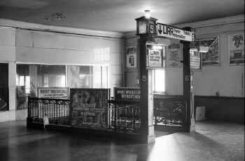
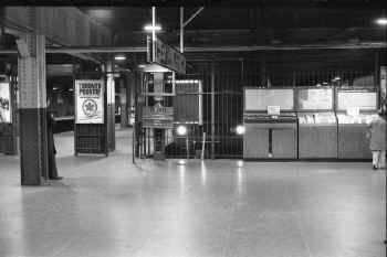
Gate and stairs for tracks 5 and 6 as viewed from the
street-level waiting room and concourse. A sign on the gate
indicates that the ticket offices are located down at track level.
The street-level ticket windows at the waiting room are no longer in
service - 10-13-78 (Wm. Madden photo, Dave Keller archive) |
Gate and stairs for tracks 1 and 2, 3 and 4 as viewed from the
street-level waiting room and concourse. Visible in the left
background is the row of old shoe-shine elevated seats and in the
right background is an out-of-service lunch counter - 10-13-78 (Wm.
Madden photo, Dave Keller archive) |
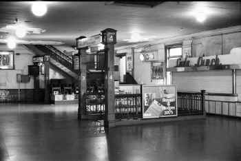
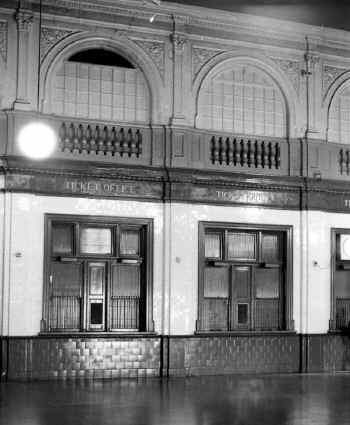
A view of the out-of-service, street-level ticket windows in the
waiting room - 10-13-78 (Wm. Madden photo, Dave Keller archive)
|
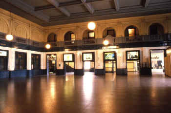
Flatbush Ave Station interior 4/1979 Photo/Archive: Bill Mangahas |
Flatbush Ave Station interior - LIRR Track 2
4/1979 Photo/Archive: Bill Mangahas |

Flatbush Ave Station interior 4/1979
Photo/Archive: Bill Mangahas |
Another view of the out-of-service, street-level ticket windows
in the waiting room, showing the decorative, arched windows above,
which once allowed light to stream into the grand waiting room but
which have, over the years, for some unusual and unexplained reason,
been painted over, turning the well-lit concourse into a dreary
venue - 10-13-78 (Wm. Madden photo, Dave Keller archive) |
A view of the
dreary, once-grand waiting room with more of the arched,
painted-over windows seen above left and a balustrade balcony above
center. This view is looking towards the gates to tracks 1 and 2, 3
and 4, just beyond the doorways in the wall. The shoe-shine booth
is visible at the left - 10-13-78 (Wm. Madden photo, Dave Keller
archive) |
Tracks 5 and 6 looking west towards the rack of telephone booths and the subterranean concourse beyond - 10-13-78
(Wm. Madden photo, Dave Keller archive) |
Tracks 3 and 4 looking west towards the bumpers and subterranean
concourse beyond. An M1 train is awaiting boarding at track 4 at
the left - 10-13-78 (Wm. Madden photo, Dave Keller archive) |
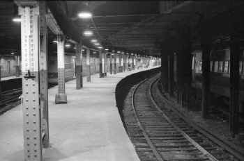
Tracks 3 and 4 looking west towards the bumpers and subterranean
concourse beyond but from a vantage point further east, showing the
curved platform condition that was common at the Flatbush Avenue
terminal. When the terminal building opened in 1906, these curved
tracks and platforms were not an issue as they accommodated the
much-shorter MP41 electric cars. As years progressed, and longer MU
cars were placed in service, it became a hazard to spot a train of
those cars here, as a huge gap was created at the platforms as a
result. Seen here, an M1 train is awaiting boarding at track 4 at
the left - 10-13-78 (Wm. Madden photo, Dave Keller archive)
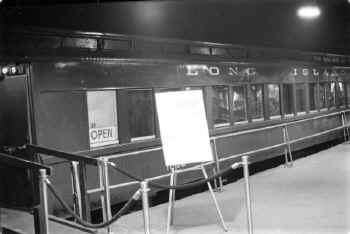
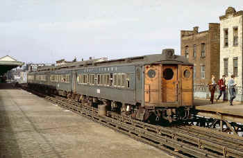
MU 1632 Nassau County Heritage Train On Display - Flatbush Ave
Brooklyn 10/13/78 (William Madden-Dave Keller)
|
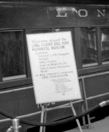
Nassau County Heritage Train Sign Display Flatbush Ave
Brooklyn 10/13/78 (William Madden-Dave Keller) |
|
Photographers are
William Madden, Art Huneke and Dave Keller (for the interior ticket
office shot) Archive for all photos: Dave Keller.
|
|
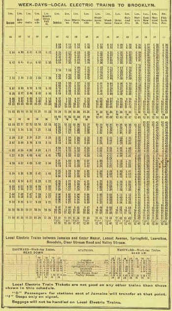
TIMETABLE
LOCAL ELECTRIC TRAINS - 1913 |
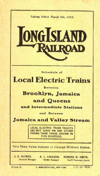
First timetable from the new Jamaica Station 3/09/1913 Archive:
Art Huneke |
 |
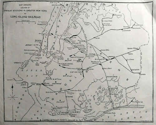
LIRR Freight Stations map c.1930 illustrates the Atlantic,
Manhattan Beach,
Bay Ridge, and Far Rockaway Branches.
|
|
ATLANTIC
BRANCH MILEAGES - 1916 MAP |
Mileages per LIRR ETT #59, effective 11/03/1910, and as
calculated from Flatbush Ave.: |
|
|
Nostrand Avenue
East New York
Warwick St.
Railroad Ave. (Autumn Ave.)
Union Course
Woodhaven
Woodhaven Jct.
Clarenceville
Morris Park(1)
MP Tower(2)
Dunton
Cedar Manor
Locust Ave. (Locust Manor)
Higbie Ave.
Laurelton
Springfield Jct.
Rosedale
Valley Stream
Note 1: (rapid transit station, not Shops)
Note 2: (per ETT #69, eff. 05/25/1913.
Does not appear
on ETT #59)
|
1.5
4.0
4.8
5.8
6.3
6.7
7.2
7.8
8.2
8.8
8.9
10.8
11.7
12.6
13.1
13.3
13.8
15.7 |
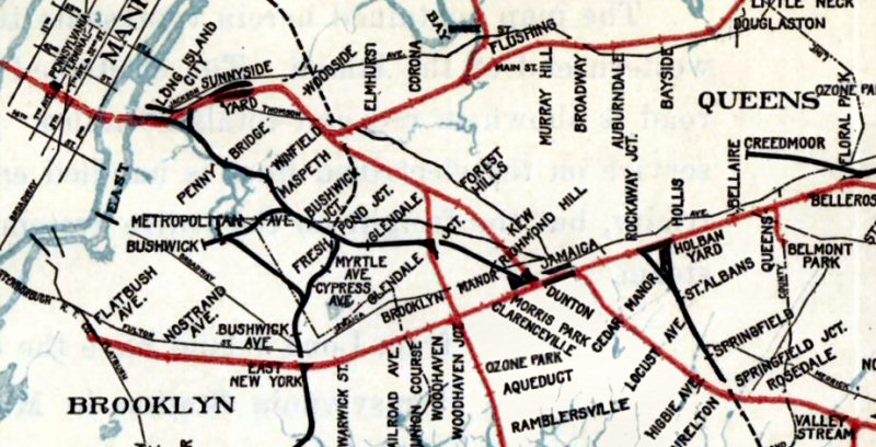
Atlantic Branch 1916 zoom map
|
|
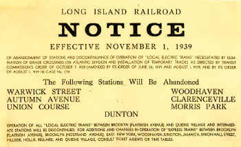 As a result of the scheduled 1939-40 grade elimination project, the following seven rapid transit stops were eliminated: Warwick St., Autumn Ave., Union Course,
Woodhaven(3), Clarenceville, Morris Park and Dunton. (LIRR official announcement
effective November 1, 1939 courtesy of As a result of the scheduled 1939-40 grade elimination project, the following seven rapid transit stops were eliminated: Warwick St., Autumn Ave., Union Course,
Woodhaven(3), Clarenceville, Morris Park and Dunton. (LIRR official announcement
effective November 1, 1939 courtesy of
Dave Morrison)
Note 3:
Woodhaven Jct. was retained as a station stop with a new,
subterranean station constructed but the "junction" was
dropped from the name, becoming the replacement "Woodhaven"
station, 1/2 mile east of the defunct Woodhaven rapid
transit station stop.
|
|
Nostrand Avenue
|
|
Nostrand
Avenue STATION:
1st DEPOT BUILT:
18xx? (BRICK BLDG.) ALSO USED AS ATLANTIC RAPID TRANSIT STOP PER ETT
#11, EFF. 11/4/1878.
ELEV. TRACKS IN SVC: 11/21/1903 DEPOT AT STREET LEVEL IN USE.
2ND DEPOT (AT TRACK LEVEL) IN SVC: 8/29/1905. AGENCY
CLOSED: 8/19/2009. |
This is the Bedford Ave. crossing at Atlantic Avenue c. 1900. The
crossing is protected by barrier gates which were raised and lowered
horizontally. Bedford Ave. was located just west of the Nostrand
Ave. station in Brooklyn and was an original station stop on the
LIRR from c. 1836 until 1861. It became a rapid transit stop on
11/4/1878 and lasted until November, 1905 when it was removed after
electrification of the branch from Flatbush Ave. eastward. (Dave
Keller archive and data) |
A distant steam locomotive and train is heading westbound towards
the crossing of Nostrand Ave. at Atlantic Ave. in this c. 1900 view
looking east. The crossing is protected by barrier gates. To the
left of the tracks beyond the crossing can be seen the low, wooden
Nostrand Ave. station platform with kerosene platform lamp. To the
right of the tracks can be seen an unpaved Atlantic Ave. A Lorimer
Street trolley approaches the crossing at the far right. (Dave
Keller archive and data) |
Emery map - Nostrand Ave. 4/1959
Archive: Dave
Keller

Nostrand Ave view E 2022
Photo/Archive: Paul Kennedy |
MU Wooden baggage car - Running extra - Atlantic-Nostrand
Aves, Brooklyn c. 1915
An old, wooden MU baggage car flying white
"extra" flags is running light westbound after leaving the elevated
Nostrand Ave. station visible in the background. The train has come
off the elevated structure just west of the station and is about to
enter the tunnel portal to access the subterranean track level of
the Flatbush Ave. terminal. This image was photographed c. 1915
(Dave Keller archive)
|
MP41 train westbound for FBA approaching tunnel to FBA-Nostrand Ave.
Station in background -View E c.1915
Photographed at the same location and date as
the image at the left and headed in the same direction, a 3-car
"sandwich" train consisting of a front and rear steel MP41 class MU
electric motor car with a wooden trailer coupled between. This
practice was quite common on the LIRR at the time until all wooden
cars were removed from service approximately a decade later. The
elevated Nostrand Avenue station is visible in this background as
well.
(Dave Keller archive) |
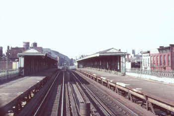
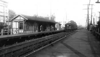
Looking east we see the elevated LIRR station at Nostrand Avenue and
the elevated viaduct carrying the Atlantic branch tracks through
this portion of the line c. 1920. Just west of this station the
tracks dip down and enter a tunnel to access the subterranean
platform level at Flatbush Ave. terminal. The sign over the stairs
reads "Trains to Jamaica and Points East." Note the gas streetlight
in the left foreground. This station had many linear feet of
beautiful decorative wrought-iron railings. (Dave Keller archive and
data)
|
Looking west from the rear of an eastbound train on November 1,
1970, the Nostrand Ave. station is seen at elevated track level. The
decorative wrought-iron rails are visible along the platforms as
well as the old-style, gooseneck platform lamps. In the distance the
tracks can be seen dipping down to enter the tunnel that accesses
Flatbush Ave. terminal. (Dave Keller archive and data)
|
MU train - Nostrand Ave View W 1970
- eBayLooking northwest, a 4-car MP54 electric train
pulling a railfan extra is on the westbound track at the elevated
Nostrand Ave. station. The center guy with the checkered jacket in
the group of three railfans (Ed Gloeggler, Ray Kenny, Ed Koehler,
Jr.) at the far right is retired LIRR
acting-president Raymond P. Kenny back when he was a college student
in 1970.
|
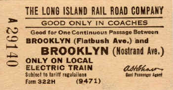
Ticket - Flatbush Ave. to Nostrand Ave. c.1929+
Archive: Brad Phillips
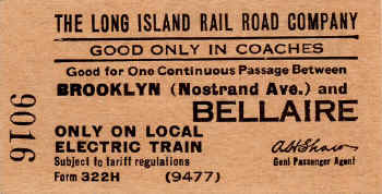
Ticket - Nostrand Ave. to Bellaire c.1929+
Archive: Brad Phillips
|
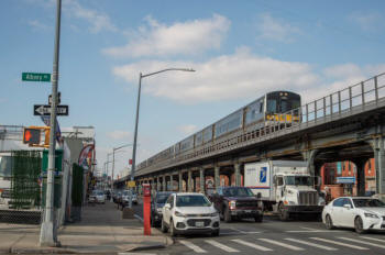
M7 7308 (Bombardier Transportation, 10/2004) leading train #2818
(Atlantic Terminal-Far Rockaway) east of Nostrand Avenue station at
(obviously) Albany Avenue. View west on 2/8/2023.
Consist: 7308-7307+7280/7087+7624/7219
The outer walkways along the elevated structure here were only
installed when it was rebuilt back in the 1990s (I think it was the
90s!)This section of elevated, from Nostrand Avenue to Ralph
Avenue,
was opened in 1903, two years before the electrification.
Info/Photo/Archive: Jeff Erlitz |
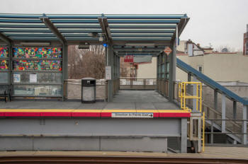
Nostrand Avenue Station - View N at the east end of the
westbound platform with access to New York Avenue. Completely
rebuilt just two years ago with he glass-top platform canopies,
allowing maximum light onto the platforms, extend all the way to the
platform edge. 2/22/2023 Photo/Archive: Jeff ErlitzNote: Derrick
Adams’ contribution to this rehab, Around the Way (2019), is on many
of the wall panels on both platforms. Adams is a local artist in
this neighborhood. |
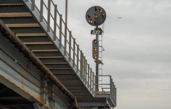
Automatic Block Signal A27 on Track 1 east of Nostrand Ave displays
"Approach-Medium" 2/22/2023
Photo/Archive: Jeff Erlitz |
|
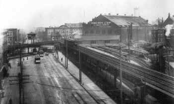
East New York
|
|
EAST
NEW YORK STATION: HOWARD HOUSE HOTEL SERVED AS ORIGINAL DEPOT AS FAR BACK AS 1853.
ALSO SERVED AS RAPID TRANSIT STOP PER ETT #11, EFF: 11/4/1878.
STATION STOP RELOCATED TO JCT. OF MANHATTAN BEACH BRANCH AT ATLANTIC AND VAN SINDERIN AVES.
EFF: 1/1/1884 WHERE THE NY & MB RY?S NEW HOTEL/DEPOT HAD BEEN BUILT THE YEAR PREVIOUS TO REPLACE AN OLDER
HOTEL/DEPOT STRUCTURE IN USE. KNOWN AS ?MANHATTAN CROSSING? AND ?MANHATTAN BEACH CROSSING,?
DEPOT WAS USED JOINTLY BY BOTH RAILROADS AND ALL STOPS AT HOWARD HOUSE CEASED. RENAMED ?EAST NEW
YORK? IN 11/1905 WITH INAUGURATION OF FULL ELECTRIC SERVICE. STATION BUILDING ABANDONED: 11/1915 AND RAZED DUE
TO BAY RIDGE BRANCH GRADE ELIMINATION PROJECT.
3RD DEPOT WITH HIGH-LEVEL PLATFORMS AT STREET LEVEL IN SERVICE: 1915. RAZED: 1941
WITH ATLANTIC AVE. GRADE ELIMINATION PROJECT (1941-43)
4TH DEPOT OPENED: 1943 WITH TRACKS SLIGHTLY DEPRESSED AND ATLANTIC AVENUE BUILT ON A STRUCTURE DIRECTLY
OVERHEAD. AGENCY CLOSED: 8/19/2009.
|
East New York Station 1910
Looking northwest, we see the joint NY & Manhattan Beach
Railway/LIRR depot at East New York c. 1910. This depot was opened
by the NY & MB in 1883 and served as their depot and hotel. It
became a joint depot with the LIRR on January 1, 1884. The building
was located between Atlantic and East New York Avenues at Van
Sinderen Avenue at what was then called "Manhattan Crossing" and
"Manhattan Beach Crossing," where the NY & MB Railway's line to
Manhattan Beach crossed the LIRR's Atlantic branch tracks at grade.
When the NY & MB was acquired by the LIRR, the branch became known
as the Manhattan Beach / Bay Ridge branch. This old wooden-framed
depot was abandoned in November, 1915 and razed account of the
LIRR's Bay Ridge branch grade elimination project. This elimination
project resulted in concrete tunnels being constructed under the
LIRR's Atlantic branch at East New York between 1913 and 1915 and
the tracks subterranean through the area.
|
East New York Station - 11/10/1910
Photo: LIRR Valuation Archive: Dave Keller
Another view of the East New York station looking north along the
former NY & Manhattan Beach Railway tracks (LIRR Manhattan Beach /
Bay Ridge branch) on November 10, 1910. Just beyond the 2-story
station building can be seen the elevated "NO" tower straddling the
LIRR's Atlantic branch. The tower controlled the at-grade track
crossings. (LIRR valuation image)
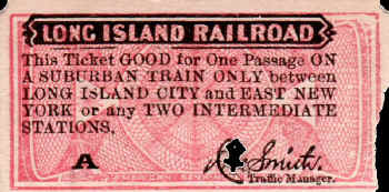
Ticket - LI City to East New York c.1900+ Archive: Brad Phillips
|
East New York Station - 11/16/1910
Photo: LIRR Valuation Archive: Dave Keller
East New York station looking west along East New York Ave. on
November 1 6, 1910 (LIRR valuation image//Dave Keller archive)
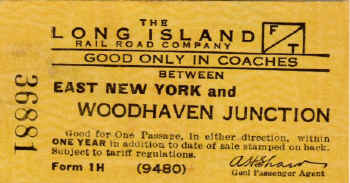
Ticket - East New York to Woodhaven Junction 1929+
Archive: Brad Phillips
|
We are looking north along the Manhattan Beach/Bay Ridge branch
tracks as they cross the Atlantic branch at grade at East New York
in Brooklyn on APRIL 24, 1913. At the far left is the elevated
"NO" signal tower which protected the crossing. The
station was just to the left of the tower outside the limits of this
photo. (Dave Keller archive and data) |
Another view of "NO tower looking northwest on February 18,
1915 shows the lead motor of a westbound MP41 MU train stopped at
the Manhattan Beach crossing to allow a freight train of gondola
cars to pass, probably being used in the grade elimination project
of the Bay Ridge branch. (Dave Keller archive and data) |
Jump ahead two years and we see the same location only with some
major changes. First, "NO" tower is no longer in
existence, and . . . the Manhattan Beach / Bay Ridge branch tracks
have been removed from their former location at-grade and have been
relocated in tunnels that have been constructed under the East New
York station facilities. The stacks of structural steel in the
center of the image are most probably for the
about-to-be-constructed BRT EL structures that will cross the LIRR's
tracks. (Dave Keller archive and data) |
"NO" Tower - BRT El - View E 1913
Archive: Dave Keller
Looking East at the East New York station in 1913, we see "NO"
interlocking tower and signal bridge at "Manhattan Crossing," where
the Manhattan Beach / Bay Ridge branch crossed the LIRR's Atlantic
branch tracks at grade. The BRT EL structure is visible just beyond
the tower.
|
East New York Station Atlantic Ave. View E - BRT 622 105 at
Atlantic Ave Station, Fulton Street Line c.1915
Looking east from the eastern end of the East New York station
platform, we see a couple of old, wooden EL cars at
the BRT's
Atlantic Ave. station c. 1915.
|
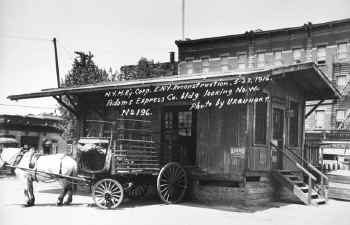
This is the old express house at East New York station. The view
looking northwest was photographed by one Urquhart who took many
insurance photos of the BRT around the time of this one, which was
shot on May 22, 1916. Mr. Urquhart probably photographed this
non-BRT, LIRR structure as he's noted in the image the "E.N.Y.
Reconstruction" which probably meant the construction of the
BRT EL through this area. At the time of this photo, the Adams
Express Co. handled express service on the LIRR. (Dave Keller
archive and data) |
East New York Station - BRT El -
View E 3/19/1920
Again, we're looking east but from further west on the station platform at East New York on March 19, 1920. The express house is visible to the right of the mid-track fence. The BRT EL structures for the Fulton and Canarsie lines are overhead. The ticket office / waiting room was located further south, away from the Atlantic branch tracks and set on a diagonal, paralleling an access track that curved off the Atlantic branch and connected with the southbound subterranean tracks of the Manhattan Beach/Bay Ridge branch. The track connection was later removed but the ticket office left in
situ. |
East New York - Snediker Ave-Williams Place ENY Ave.
crossing Fulton-Canarsie Els View N c.193- View N c.1938
This c. 1938 view is looking north at Snediker Avenue and Williams
Place at the eastern end of the station platform at East New York,
directly under the BRT's Fulton and Canarsie line EL structures. The
Bay Ridge branch tracks are now underground at this location. What
looks like a signal tower at the right is actually a crossing tower,
where the crossing watchman would manually raise and lower the
crossing gates at train time. (Dave Keller archive)
|
East New York - Snediker Ave-Williams Place ENY Ave. crossing Fulton-Canarsie
Els - View NE c.1938
This is a better view of the area taken at the same time but looking
NE. The two EL trestles for the Fulton and Canarsie lines are easier
to see. (Dave Keller archive)
|
East New York Station View W from BMT Canarsie
El 1938
Looking west from the BRT EL structure, we see the East New
York station with pedestrian crossover. At the far left can be seen
the LIRR ticket office and waiting room set at a diagonal as
indicated previously. The curving access track to the branch is no
longer in place. (George E. Votava photo/Dave Keller archive) |
MP41 westbound train approaching
East New York Station View E from Canarsie El 5/1939
An MU train consisting of MP41 cars heads westbound, approaching
East New York station in May of 1939. Viewed east from the BRT EL,
we see in the distance the LIRR's elevated structure which carried
the tracks part-way along Atlantic Avenue, ending just west of the
Warwick Street station. The tracks then returned to grade, and were
elevated again west of East New York, to just west of the Nostrand
Ave. station, where they went underground to access the Flatbush
Ave. terminal whose tracks and platforms were subterranean. (Dave
Keller archive) |
MU train - East New York station View E 1940
Eastbound MU train leaving East New York station. View is looking E from the
BMT Fulton EL. The Canarsie EL and Fulton EL were adjacent to each other
as they passed over the LIRR's East New York station at grade. The
Canarsie El was on the west side and the Fulton El was on the east side.
As this view is looking E, it was taken from off the Fulton EL.
This photo shows the tracks removed and ties still in place. All in
preparation for the grade elimination project .
Info: Dave Keller
|
|
|
MP54s on elevated Atlantic Ave c.1965 (Maywald-Boland) |
|
|
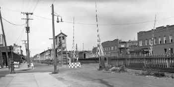
WARWICK
STREET
|
|
WARWICK
STREET STATION: ELEVATED STRUCTURE OPENED: 8/29/1905 WITH ELECTRIFICATION FROM FLATBUSH AVE.
OUT OF SVC: 11/1/39 PER G.O. #1204 AND RAZED WITH ATLANTIC AVE. IMPROVEMENT PROJECT: 1939-40
|
This is a birds-eye view of the elevated Warwick Street station in
East New York. The view is looking southeast in 1938. It was opened as a rapid transit station stop and taken out of service in November, 1939 along with other former rapid transit stops, during the grade elimination project of 1939-40.
Archive: Art Huneke |
Ticket - Flatbush Ave. to Warwick Street GPA: P.H. Woodward c.
c.1920's Archive: Brad Phillips
|
|
DIANA COAL & OIL CO. |
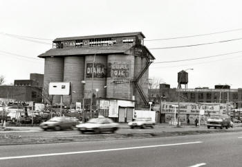
Diana Coal & Oil Co. View SE 6/1994 Photo/Archive: Jim Mardiguian
Atlantic Branch Fountain Ave., Brooklyn - View E toward Crescent Street
Connection c.1920 Archive: Jeff Erlitz Joint LIRR/BRT
service to the Rockaways ended in 1917. The Crescent St. connection remained in
place until about 1922 according to Emery and per CN Interlocking blueprints
(below). Note the James V. Osborne photo of CN Tower across the tracks in 1923
(below) and the connection structure is gone. Dave Keller |
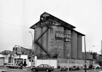
Diana Coal & Oil Co. View SE 6/1994 Photo/Archive: Jim Mardiguian

Milford St. to Autumn Ave. pre-1922 Emery Map 6/1959
Atlantic Branch: Elevated, East New York to Shepherd Avenue:
1903-1942 Info: Robert Emery
|
Emery noted that the siding was originally John R. Hughes, then
Atlantic-Logan Coal Company in 1919 and finally was Rubel Corporation in 1930.
CR4 1919: Atlantic Logan Coal Co. at A5-3/4 and located 5.50
miles from Flatbush Ave.
not on CR4 1913, therefore 1913-1919.
CR4
1924: Rubel Coal & Ice Corp. at A5-1/2, and located 5.26 miles from Flatbush
Avenue. This company came into being between 1919 and 1924.
Atlantic Logan Coal Co. renamed Rubel Coal & Ice Corp. at A5-3/4 and
located 5.50 miles from Flatbush Ave. Renaming of the company occurred between
1919 and 1924. (Two Rubel locations within 1/4 mile of each other in 1924.)
Research: Dave Keller
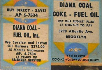
Diana Coal matchbook cover indicates 16 years of service c.1954 placing Diana
Coal 1938-39.
Diana Coal & Oil matchbooks later changed to telephone TAylor 7 -1534. |
|
|
1913 aerial photo (cropped) from Dept. of Parks under Robert Moses entitled:
"Conduit Boulevard, Atlantic Avenue to the Belt Parkway"
issued in 1941.
Archive: Neil Sullivan |
Incorporated from December 7, 1955 through March 25, 1981. The silos were
torn down in March 2003 after bankruptcy and failure to pay state corporation
taxes. |
|
railroad
ave. - (autumn Ave.)
|
|
railroad
ave. - (autumn
Ave.) STATION: OPENED: 4/28/1905 AS RAILROAD AVENUE(?) WITH ELECTRIFICATION FROM FLATBUSH AVE.
NAME CHANGED: ? OUT OF SVC: 11/1/39 PER G.O. #1204 AND RAZED WITH ATLANTIC AVENUE IMPROVEMENT PROJECT: 1939-40
|
"CN" Interlocking - 1912 |
"CN" Interlocking - 1922 |
Ticket - Jamaica to Autumn Ave. c.1929+ Archive: Brad Phillips
|
|
These two interlocking blueprints show the Chestnut Street Junction / Autumn Avenue location. The first blueprint shows the actual junction of the BRT connection with the LIRR's Atlantic branch via curving inclined ramps west of "CN" tower as it appeared in 1912. The second blueprint shows that area again in 1922 after the Chestnut Street Junction had been renamed, BRT connection and inclined ramps removed and the interlocking reworked.
Archive: Art Huneke Info: Dave Keller |
Looking west from the cobble-stoned and planked Autumn Ave. (Railroad Ave.) crossing at the Autumn Ave. station in 1923, we see the elevated "CN" interlocking tower built on a signal bridge across the tracks. Originally named tower "65", it was placed in service in August, 1906 to control the connection between the LIRR and BRT systems during their period of joint operations. The tower was renamed "CN" (for the Chestnut Street incline connection) in 1907 and the BRT connection was removed in 1917 along with the inclined ramps constructed on either side of the tracks to bring the elevated trains down to, or up from, grade level. The interlocking plant was rebuilt in 1922 and the tower renamed "AUTUMN" in April, 1937. It remained in service until December 27, 1939 when it was closed due to the grade elimination project of 1939-40. (James V. Osborne photo, Dave Keller archive)
|
Here's a terrific close-up view of "CN" tower looking
southeast from Hemlock Street and Atlantic Avenue, towards the
Autumn Avenue station which is visible in the left background of
this photo taken on July 27, 1930). Note the semaphore block signals
visible in the previous 1923 view have been replaced with
position-light signals. (Percy Loomis Sperr photo, Dave Keller
archive) |
This is a close-up of the block office at "CN" tower. Notice the keystone-shaped call letters sign, the single, bare light bulb suspended out on a pole to light up the stair landing, and an exterior pot-bellied stove which doesn't appear to have any stovepipe attached. (Percy Loomis Sperr photo, Dave Keller archive)
|
Here we are at the crossing of Autumn Avenue at Atlantic Avenue on July 27, 1930. We're looking southeast along Atlantic Avenue towards the Autumn Avenue station. Prior to the grade elimination project, Atlantic Avenue ran on both sides of the LIRR's tracks. That portion of the branch that was not on an elevated viaduct but at-grade was separated from the tracks by many miles of wooden, picket fencing. Note the elevated crossing tower from which the crossing watchman would manually operate the crossing gates at train time. In addition to regular train service, rapid transit service operated along the Atlantic branch between 1905 and 1939, so the crossing watchmen had a very busy job on any given day. (Percy Loomis Sperr photo, Dave Keller archive)
|
This is a closer view of the elevated crossing tower at Autumn Avenue taken on the same day as the previous view. Note the two covered stairwells to the left and right of the women crossing the tracks. These were for pedestrians to cross the tracks safely via a subterranean tunnel. The sign reads "DO NOT CROSS TRACKS - USE SUBWAY." As the tunnel most probably stunk of urine and may have had undesirables hanging out down there intending harm, the women, wearing summer dresses, white hats, white gloves and white shoes, decided to cross the tracks at street level. (Percy Loomis Sperr photo, Dave Keller archive) |
Standing on the wooden station platform at Autumn Avenue and looking west on October 26, 1939, we see the various wooden shelters and possible 2-door outhouse facility at the right-of-center of this view on the westbound platform. The proximity of the two doors indicates to me "men" and "women." In the distance can be seen "AUTUMN" tower which had been renamed 2-1/2 years earlier from the previous
"CN". (Dave Keller archive) |
|
UNION COURSE
|
|
UNION COURSE STATION:
LISTED ON TT OF 3/1837 TO SERVICE UNION COURSE RACE TRACK, BUT MAY HAVE OPENED IN 1836. EARLIER SERVICE MAY HAVE BEEN TO UNIONVILLE STATION.
RAPID TRANSIT SERVICE BEGAN: 4/28/1905, PLATFORMS WIDENED: 1911.
OUT OF SVC: 11/1/39 PER G.O. #1204 AND
RAZED WITH ATLANTIC AVENUE IMPROVEMENT PROJECT: 1939-40
|
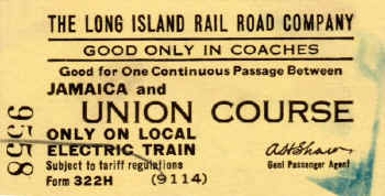
Ticket - Jamaica to Union Course c.1929+ Archive: Brad Phillips
|
|
|
|
|
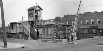
The gates are down at the 80th St. and Rockaway Blvd. grade crossings and there's a bit of a crowd awaiting the westbound train in this c. 1924 NW view of Union Course station. The elevated crossing tower is visible at the west end of the platform. This was one of the very first stations on the Atlantic branch, originally appearing on timetables of March, 1837 to service the Union Course racetrack which was located on the north side of the tracks. High level wooden platforms and wooden shelters were added with the advent of rapid transit service effective 4/28/1905. (James V. Osborne photo, Dave Keller archive)
|
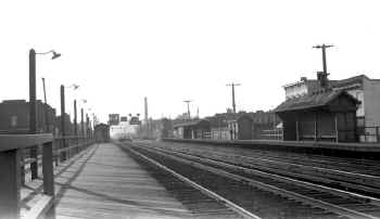
Union Course Station, Woodhaven zoom View E 7/27/1930 (Sperr-Keller)
|
In 1925, the 80th St. and the diagonal Rockaway Blvd. grade crossings were eliminated and the elevated crossing tower removed. 80th St. was severed at Atlantic Avenue and Rockaway Blvd. was bridged over the tracks. The station platforms were extended at their western ends, and stairs added accessing the overpass to act as a pedestrian crossover for the station stop. This view of Union Course station is looking east from the Rockaway Blvd. overpass on 7/27/1930. A distant MU train is headed eastbound on the express track. The severed 80th St. is visible at the barber shop at the left. (Percy Loomis Sperr photo, Dave Keller archive)
|
This is a similar eastward view of the Union Course station shot from the Rockaway Blvd. overpass on 10/26/39, six days before the rapid transit station stop was taken out of service with the grade crossing elimination project of 1939-40. Both stairs accessing the diagonal overpass are visible in this view. (Dave Keller archive)
|
Notes on the photo above:
1. The vertical ropes in the photo over the westbound tracks are the "tell-tails" that dangled off a cantilevered column to warn railroad men atop a car that a bridge was approaching and to get down quickly.
2. The MU train is on the eastbound express track. What's interesting is that the motorman appears to have neglected to turn off his headlight but marker lights are not lit. He wouldn't be operating westbound on the eastbound track unless there was a tie-up on the westbound track further west, or he flipped the wrong switch, meaning to turn on markers but turned on headlights instead. Or maybe the markers weren't working on that car and the conductor saw fit to use the headlight as a marker (?).
Or maybe there WAS a tie-up ahead. We'll never know.
3. The station building shows a close-up of the Pennsylvania Keystone Logo wooden station sign.
4. The ticket office is visible in the front left of the man standing on the platform.
5. The small, enclosed waiting room has a railing in front keeping passengers from trying to walk that narrow section of platform and fall onto the tracks. Access to the rest of the westbound platform was
through the waiting room, which had a door on each side.
6. There's a Chiclets dispenser hanging on the wall on the west face of the waiting room.
7. Gooseneck platform lamp to the left of the waiting room.
8. At westbound automobile on Atlantic Avenue to the left of the tracks.
9. In the distance, the elevated crossing shanty at 87th Street and Woodhaven station. Note the proximity of the rapid transit station stops and why the LIRR chose to remove most of them when the tracks were relocated below Atlantic Avenue! Think of the expense of all the new stations that would have had to have been constructed and I'd gather ridership no longer favored those stops.
Info: Dave Keller |
|
|
|
WOODHAVEN
|
|
WOODHAVEN
(1st): ORIGINAL MAIN LINE
BETWEEN BROOKLYN AND JAMAICA ORIGINALLY OPENED AS
CONNECTICUT AVE. (1837) ON ORIGINAL MAIN LINE BETWEEN BROOKLYN AND JAMAICA.
BECAME TROTTING COURSE AND THEN TROTTING COURSE LANE TO SERVICE THE CENTREVILLE RACE COURSE
(TROTTING COURSE). LISTED AS SUCH ON TT OF 1842.
NAME CHANGED TO WOODVILLE AND LATER TO WOODHAVEN.
RAPID TRANSIT SERVICE STARTED: 4/28/1905 WITH ELECTRIFICATION FROM FLATBUSH AVE. PLATFORMS WIDENED: 1911. OUT OF SVC: 11/1/39 PER G.O. #1204 AND RAZED WITH ATLANTIC AVENUE IMPROVEMENT PROJECT: 1939-40
|
|
WOODHAVEN
(2nd): FORMER LOCATION OF WOODHAVEN JCT. STATION. TRACKS AND STATION
PLACED BENEATH ATLANTIC AVE. 1939-40. THE ACTUAL JUNCTION WAS TAKEN OUT OF
SERVICE: 6/8/62 AND THE ROCKAWAY BEACH BRANCH ABANDONED: 6/9/62.
"JUNCTION" WAS DROPPED FROM THE NAME AND STATION STOP RENAMED "WOODHAVEN."
THE RAPID TRANSIT STATION KNOWN AS "WOODAVEN" ORIGINALLY WEST OF THIS LOCATION
WAS LONG OUT OF SERVICE AT THIS TIME (11/01/39), SO THERE WAS NO CAUSE FOR ANY
CONFUSION WITH THIS RENAMING. Research: Dave Keller |
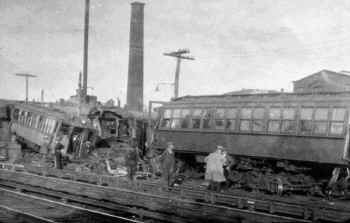
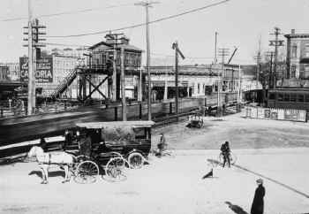
This view from April, 1925 shows the results of a collision between a LIRR MP41 MU electric train and a class H6sb (2-8-0) steam locomotive which was switching freight in Woodhaven. In the background is the Lalance & Grosjean Mfg. Co. plant, which manufactured the old style agate-wear pots and pans with a porcelain-enamel, spotted finish. (Dave Keller archive) |
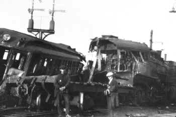
Here's
a close-up view of the same wreck, showing the destroyed cab of the
H6sb locomotive, the frame of
the tender (upper portion is missing) and a destroyed MP41 MU
car. Note the twin semaphore signals on the signal mast.
(Dave Keller archive)
|
A three-car rapid transit train is making a stop at the Woodhaven station around 1930. Woodhaven was another of the rapid transit station stops that was discontinued in the 1939-40 grade elimination project. The Woodhaven Junction station, 1/2 mile east of Woodhaven station, was rebuilt underground in this project and renamed "Woodhaven." (Dave Keller archive)
|
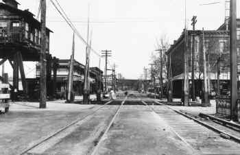
It's train time at the Woodhaven station and the gates are down. This view is looking east from the 87th Street crossing on September 29, 1938. At the far right is Atlantic Avenue, which ran on both sides of the LIRR's tracks when at grade. After the grade elimination project, the tracks that were originally at-grade were placed underground and Atlantic Avenue was constructed above them as one main road.
(Dave Keller archive)
Emery map Woodhaven Jct. post-1942 when the Atlantic
Branch was placed beneath the street. Archive: Dave Keller
Woodhaven Junction (Atlantic branch at street level,
Rockaway Beach branch crossing via trestle. After grade elimination, Atlantic
branch was put under Atlantic Ave. but Woodhaven Jct. still crossed Atlantic
Ave. on a newer trestle.)
Woodhaven Jct. only had a connection
between the two branches with a curved track in the southwest quadrant of the
junction. MU trains running southbound along here to Brooklyn would cross the
Atlantic branch, clear the switch south of the station, then reverse direction
and head westward to Flatbush Avenue. This procedure would be reversed to head
BACK to Penn Station. Dave Keller |
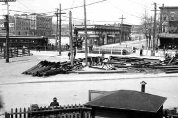
Taken on the same day, the gates are still down at the 87th Street crossing at Woodhaven station. The crossing watchman in the elevated crossing tower has manually cranked them down, and the flashing lights are mounted on a concrete island stanchion in the center of the street. This view is also looking east, with a truck heading up Atlantic Avenue. The large smokestack in the right background is that of the Lalance & Grosjean Mfg. Co. It appears the crossing watchman is holding some sort of conversation with the photographer.
(Dave Keller archive)

The lower level street entrance to Woodhaven
Station is view NW from the south side of Atlantic Avenue (see map
left). The elevated Woodhaven Jct. Station on the Rockaway
Beach branch. The upper level had been closed for nearly three
years, as service ended in 1962, still had two stairwells visible in
this photo. 4/21/1965
Photo/Archive: Richard Makse |
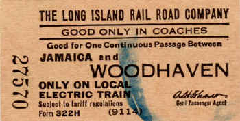
Ticket Form 322H - Jamaica to Woodhaven c.1929+
GPA: A. H. Shaw Archive: Brad Phillips
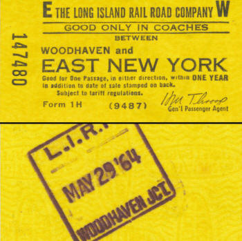
Ticket Form 1 H -Woodhaven and East New York
5/29/1964 Archive: Richard Makse
The ticket was purchased at the Atlantic branch Woodhaven
Station, formerly Woodhaven Jct., which agency was still in service until at
least 1966, possibly later.
After the 1940-41 improvement, the station on the Atlantic branch was
referred to as "Woodhaven Jct" and the elevated station on the Rockaway Beach
branch was referred to solely as "Woodhaven." Dave Keller
|
|
WOODHAVEN JCT.
|
|
WOODHAVEN JCT. STATION:
OPENED: 7/1895. WAS ALSO ONE OF THE LIRR's RAPID TRANSIT STOPS.
RAZED : 11/1939 WHEN TRACKS PLACED BENEATH ATLANTIC AVE. WITH ATLANTIC AVE. IMPROVEMENT PROJECT OF 1939-1940.
(Valuation photo from 11/21/1939 shows demolition underway.)
2ND DEPOT, LOCATED UNDERGROUND, OPENED: 1940-41. RENAMED ?WOODHAVEN? TO REPLACE THE RAPID TRANSIT STOP
ORIGINALLY LOCATED FURTHER WEST AND WHICH WAS REMOVED BY THE ATLANTIC AVE. IMPROVEMENT PROJECT.
THE ?JUNCTION? PORTION OF THE STATION NAME WAS ELIMINATED AT THIS TIME ALTHOUGH THE JUNCTION REMAINED IN SERVICE. THE ACTUAL
JUNCTION WAS TAKEN OUT OF SERVICE: 6/08/1962 AND THE ROCKAWAY BEACH BRANCH ABANDONED: 6/9/1962.
PART TIME AGENCY PER "L.I.R.R. TICKET OFFICES OPEN FOR SALE OF TICKETS" OF 9/12/55. AGENCY LAST NOTED IN "LIRR TICKET OFFICE HOURS" LISTING OF
9/25/1966. AGENCY GONE BY LISTING OF 5/22/1967 (Brad Phillips data). DISCONTINUED AS STATION STOP: 1/10/1977.
Research: Dave Keller |
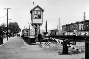
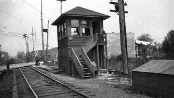
A five-car MU train consisting of MP41 electric cars is viewed from "WT" tower on September 1, 1907. The lead car is on the track curving to the left and is headed southbound onto the connection leading to the Rockaway Beach branch. The continuous wooden picket fencing separated the tracks from Atlantic Avenue, shown here as an unpaved dirt road on both sides of the tracks. This is Woodhaven Junction and the tower, originally identified as "66," controlled this junction by 1884. The tower was renamed "WT" in 1907 and "HAVEN" on April 15, 1937. It was taken out of service on February 29, 1940 due to the grade elimination project and a new, subterranean tower was built, retaining the "HAVEN" name. (Dave Keller archive)
Ticket Form 1 H -Woodhaven and East New York
5/29/1964 Archive: Richard Makse
The ticket was purchased at the Atlantic branch
Woodhaven Station, formerly Woodhaven Jct., which agency was still
in service until at least 1966, possibly later.
After the 1940-41 improvement, the station on the Atlantic branch
was referred to as "Woodhaven Jct" and the elevated station on the
Rockaway Beach branch was referred to solely as "Woodhaven."
Dave Keller |
Here's "WT" tower at Woodhaven Junction looking east on April 24, 1918. The depot is blocked from view by the interlocking tower at the right but the high-level wooden platforms are visible in the distance. A boxcar is spotted on the team track behind the depot and the elevated crossing tower with watchman is visible at the far left. The watchman would manually operate the crossing gates from this tower. In the distance can be seen the bridge carrying the LIRR's Rockaway Beach branch tracks. The Woodhaven Junction station on that branch was accessed by stairs leading from the station platform on the Atlantic branch below. The cutoff connecting the two branches as seen in the previous image was behind the photographer. (LIRR valuation photo, Dave Keller archive)
The Atlantic branch electrified in 1905 and rapid transit service
to numerous stations began on 4/28/1905. Woodhaven was one of
the rapid transit stations (RT).
Woodhaven Junction station existed as far back as the
construction of the Rockaway Beach branch. There was a station stop
and depot with agency on the Atlantic branch and a station stop with
no ticket agency (if I'm correct) on the Rockaway Beach branch which
spanned Atlantic Ave. when at-grade. There was stair access from the
Atlantic Ave. platform to the elevated station.
The trestle spanning the tracks is the Rockaway Beach branch and
that station's platforms extended over Atlantic Avenue in the photo
view E along the Atlantic branch. (right). Note the guardrails and
double sets of stairs at the distant end of the platforms.
When the Atlantic Avenue Improvement Project began in Nov. 1939,
rapid transit service came to an end and all the RT stations were
razed. Woodhaven was one of those stations razed.
The Woodhaven Junction station on the Atlantic branch was rebuilt
below grade and the station on the Rockaway Beach branch overhead
was rebuilt in 1940-41. The "junction" part of the name was
eliminated and the stations were renamed "Woodhaven" although the
junction remained in operation until service on the Rockaway Beach
branch ended in 1962.
The Atlantic Ave. Woodhaven station had a part-time agency in
1955 and was still listed as an active agency in September, 1966.
It was dropped from the listing in May, 1967 and the stop
discontinued on Jan. 10/ 1977.
The Woodhaven ticket dated 5/29/1964 (left), but still indicating
the Junction on the dater die was probably because new dies were not
issued. Why spend money when you can still get by with the dies
already in use? Chances are the dies in use at the Woodhaven RT
station were destroyed when the station stop was discontinued,
otherwise they could have used them at the former junction station.
Info: Dave Keller |

It's 1939 and almost the end of the line for the former "WT" tower now identified as "HAVEN" at Woodhaven Junction. It will be taken out of service at the end of February the following year. In the distance is an MU electric train eastbound approaching the tower and the cutoff tracks connecting the Atlantic branch with the Rockaway Beach branch are seen to the left of the train and tower. (Photographer and archive unidentified)
Looking east in this LIRR valuation image from April 3, 1916, we
see the high level platforms and depot building at Woodhaven
Junction. A whistle post is visible at the west end of the
eastbound station platform, for an upcoming grade crossing and
beyond the depot is the large, brick, LIRR Substation #3.
Beyond that the overpass carries the LIRR's Rockaway Beach branch.
The Woodhaven Junction station on that branch was located alongside
the electric substation. (Dave Keller archive)
|
|
CLARENCEVILLE
|
|
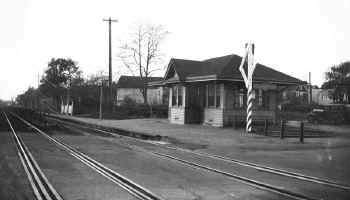
CLARENCEVILLE STATION:
BUILT: 1905 (?). OUT OF SERVICE: 11/1/39 PER G.O. #1204 AND RAZED WITH ATLANTIC AVENUE IMPROVEMENT PROJECT: 1939-40
|
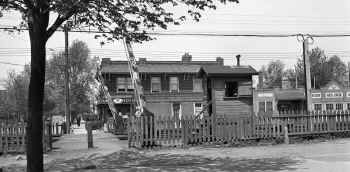
This is the Clarenceville station looking West in 1938. In the distance you
can just make out the wooden pedestrian crossover that was constructed in 1906.
Like many of the other stations along this branch, it was taken out of service
on November 1, 1939 and demolished in the grade crossing elimination project of
1939-40. (Dave Keller archive)
|
Looking east from the wooden station platform we see the old Clarenceville
station with Pennsylvania Railroad keystone-shaped station signs and gooseneck
platform lampposts. This view was photographed on October 28, 1939, four days
before the station stop was taken out of service. (Dave Keller archive)
|
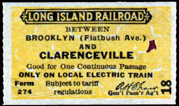
Ticket - Rapid Transit between Flatbush Ave. Brooklyn to Clarenceville c.1930
Archive: Dave Keller
|
Pedestrian crossing gates and shanty 109th Street-Atlantic Ave.,
Clarenceville View N 5/07/1934 (Sperr-Keller)
|
109th Street-Atlantic Ave., Clarenceville View N 7/27/2014 Bing
maps
|
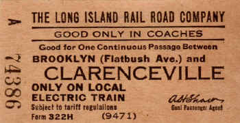
Ticket - Flatbush Ave. to Clarenceville c.1929+ Archive: Brad
Phillips
|
|
Looking north at 109th St. and Atlantic Avenue we see the pedestrian crossing, manual crossing gates and manned crossing shanty in the area of Queens once known as Clarenceville. At the time of this photo taken on May 7, 1934, the LIRR ran on the surface through here. Most of the north-south streets did not cross the LIRR's tracks. Atlantic Avenue ran parallel to the tracks on both the north and south sides of the right-of-way. With the exception of several below-ground pedestrian crossovers, this was the only at-grade footpath along the Atlantic branch. When the Atlantic Avenue grade elimination project began in late 1939, most of the former LIRR rapid transit stations were taken out of service, demolished and the tracks placed beneath Atlantic Avenue from just outside Morris Park Shops where they entered the tunnel, up to where they came out of the tunnel just east of the East New York station and began to climb a steel viaduct west of the station, until returning underground once again just west of Nostrand Avenue station for the final distance to the subterranean terminal at Flatbush Avenue. (Percy Loomis Sperr photo, Dave Keller archive and data)
|
|
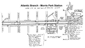
MORRIS PARK
|
|
MORRIS PARK STATION: BUILT: 1886, OUT OF SVC: 11/1/39 PER G.O. #1204 AND RAZED WITH ATLANTIC AVENUE IMPROVEMENT PROJECT: 1939-1940
|

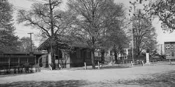
Looking south on October 12, 1905, we see the small, wooden-framed depot at Morris Park. Note the outhouse at the far left, penny scale outside the waiting room door, wooden pedestrian crosswalk across the tracks, kids sitting on the coal bin and a Dietz kerosene platform lamp to light the old wooden platforms. This was a rapid transit stop, one-half block away from the entrance to the Morris Park Shops on 120th Street, with a small park directly behind the depot building. Opened in 1886, it was discontinued as a station stop on November 1, 1939 and subsequently demolished as a result of the grade crossing elimination of 1939-40.
(Unidentified photographer and archive)
Emery map 114th St. to 500' east of 121st St.
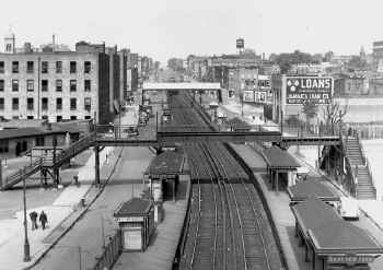
Morris Park Station - 6/1959 -
Archive: Dave Keller |
Morris Park Station - The actual depot building was off to the left, beyond the
range
of the photo. An elevated crossing guard tower in the distance view W in
1925.
Photo: James V. Osborne Archive: Mike Boland
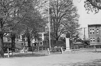
Here's the Morris Park station viewed northeast from the rear of the depot on May 7, 1934. You can see the small park that was located behind the structure. The white building in the center background is the LIRR's Morris Park Shops Maintenance of Equipment (MofE) building. (Percy Loomis Sperr photo, Dave Keller archive)
|
Here we have a zoomed-in close-up of the previous image, showing the 120th St. crossing with crossing shanty, the MofE building at the entrance to Morris Park Shops and a two-car MU electric train. In the distance can be seen some more of the Shops' buildings. (Percy Loomis Sperr photo, Dave Keller archive)

Morris Park station, view northwest c.1930. |

Atlantic Ave. and Lefferts Blvd. view S on the west side of the
Morris Park Station. The stair handrails to the platform are visible
at the far left of the image. 5/07/1935 - Archive: Kevin Katta |
Here's another rear view of the Morris Park station, only looking northwest from the park behind the depot in 1939. The windows are boarded up, probably in preparation for the grade elimination project that is soon to come tearing through here. (Art Huneke archive)
|
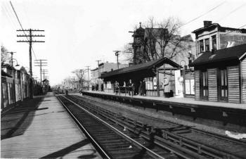
Another view of the Morris Park station, this time looking west on
September 7, 1938 from the 120th St. crossing and showing the high-level
platforms and shelter. Note the Pennsylvania Railroad Keystone station sign.
(Dave Keller archive)
|
Morris Park station from the opposite direction, looking northeast towards
the 120th St. crossing on October 26, 1939. A 3-car MP41 MU train is
heading westbound into the station. Just visible in the background behind
the train is the multi-story, white Maintenance-of-Equipment building at the
start of the Morris Park Shops. The end is very near. In six days,
this station will be taken out of service. (Dave Keller archive)
|
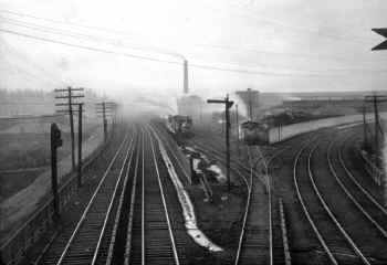
Looking west from the combination pedestrian crossover / signal bridge we
see an overall view of Morris Park Shops on December 29, 1908. Note the
triangular points of one of the semaphore signals at the upper right. At the
left are the two electrified tracks of the Atlantic branch, in the center is
the yard lead for Morris Park Shops and at the right are the non-electrified
tracks of the Montauk branch at grade. The tracks curve to the right and
just outside the view of the camera would be the "Shops" station for employees,
directly across from the Richmond Hill Storage Yard. Behind the photographer is
"MP" tower. (Dave Keller archive)
|

This is a rare view of the Atlantic branch passing Morris Park Shops and
the very tall "MP" tower. Looking west on November 9, 1911, we see the
interlocking tower at the left, a steam locomotive eastbound on the Atlantic
branch, the large pedestrian crossover/signal bridge spanning all the tracks on
the east side of the shops and locomotives laying up at Morris Park Shops. The
pile of dirt at the far right is part of the construction of the embankment
which elevated the Montauk branch through this area. "MP" tower, originally
named tower "67," (erection date not known) was renamed "MP" in 1907. It was
replaced by a new, brick tower with the same call letters, located on the
opposite side of the tracks from the old tower and slightly further east. It
was placed in service on January 20, 1914. That tower was later renamed
"DUNTON." (Dave Keller archive)
|
|
DUNTON
|
DUNTON STATION: OPENED: ? SOUTH OF THE TRACKS AND WEST OF VAN WYCK AVE. ON ATLANTIC BRANCH.
DEPOT CLOSED TO THE PUBLIC: 1892, BUT STATION STOP STILL IN USE. STATION STOP AND DEPOT RELOCATED TO NORTH OF THE TRACKS AND EAST OF VAN WYCK AVE.
TO ACCOMMODATE PASSENGERS ON BOTH ATLANTIC AND MONTAUK BRANCHES: APRIL-MAY/1897. IN SVC. 5/29/97.
CLOSED: 1910. BUILDING USED TO HOUSE ELECTRICIANS.
2ND RELOCATED DEPOT IN SVC: BY APRIL, 1914. OUT OF SVC: 11/1/39 PER G.O. #1204 AND RAZED WITH ATLANTIC AVENUE IMPROVEMENT
PROJECT: 1939-40
|
We're looking west from the signal bridge just west of Dunton station c. 1938 along the Atlantic branch towards Morris Park Shops. The grade elimination project has not yet begun and the tracks are still at grade in the distance. After the elimination was complete, the tracks entered tunnels about in line with the Maintenance-of-Equipment building at the shops. At the center are locomotives laying up at the Shops and the diagonal coaling elevator accessing the old wooden coaling tower. At the right is "DUNTON' tower, formerly "MP" but renamed on April 23, 1937. At the far right, behind the tower, is the elevated Montauk branch atop the embankment and the track under the branch, entering the tunnel, accesses the Richmond Hill Storage Yard, located on the other side of the embankment. (Dave Keller archive)
|
Looking east from in front of "DUNTON" tower on March 8, 1943, we see the signal bridge from which the previous photo was shot. Under the bridge are MU electric passenger trains laying up and in the right background is the Sheffield Farms dairy plant. At the left can be seen the stairs accessing 130th
Street (Maure Ave.) below. This is a wartime photo shot by LIRR insurance claims photographer Frederick Weber. Railroad photography was not permitted during the war years, but Weber had permission to take photographs of the LIRR as a result of his position with the company. Also prohibited was unauthorized access of rail yards. As the above mentioned stairs accessed 130th St. the guard shanty in the image was installed at the head of the stairs to keep unauthorized individuals out. (Ron Zinn archive)
|
Looking east in this LIRR valuation photo, we see Dunton station under construction on January 14, 1914. Semaphore block signals, still minus their blades, are in the process of being installed on the overhead signal bridge. (LIRR valuation photo, Dave Keller archive)

Ticket - Jamaica to Dunton c.1929+ Archive: Brad Phillips
|
Originally opened as a station stop west of Van Wyck Ave. the Dunton
station was relocated to the east side of Van Wyck Ave. to be able to service
riders on both the Atlantic and Montauk branches but it was closed in 1910.
By 1914, a brick depot building was constructed at the east end of Morris Park
Shops, with long, concrete, high-level platforms and long shelter. In
this view of Dunton station taken on July 2, 1939, the brick depot is at the
far left, at the west end of the eastbound station platform. The shelter
at the right has the Pennsylvania Railroad keystone-shaped station sign in
place. In the center is the signal bridge with semaphore block signals
and beyond it is "DUNTON" tower and Morris Park Shops. As
substantial as this station was, it, too, was removed during the grade
elimination project of 1939-40, although the tracks through here remained at
grade. Possibly ridership did not warrant the expense of the upkeep of
these facilities. (Dave Keller archive)
|
This view of "DUNTON" tower from 1967 is looking northwest with the elevated Montauk branch directly behind the tower and the tunnel accessing the storage yard is visible to the right of the tower. (Dave Keller photo and archive)
|
"DUNTON" tower is seen here on Christmas Day in 1971. The view is northeast. "DUNTON" tower was placed in service on January 20, 1914 as "MP" tower. Renamed "DUNTON" on April 23, 1937, it remained in constant use for nearly 97 years, until taken out of service on October 24, 2010. (Dave Keller photo and archive)
|
|
CEDAR MANOR
|
|
CEDAR MANOR STATION: OPENED: 1906 AS ?POWER PLACE.? RENAMED: 19 ?. OUT OF SVC: 1/28/59. DISCONTINUED AS STATION STOP. RAZED: 2/59 WITH GRADE ELIMINATION.
|

LIRR valuation photo of Cedar Manor station is looking north c. 1918. This depot was very similar in architectural style to the 2nd Calverton depot on the LIRR's Main Line. (eBay image)
|
Looking northwest from the 114th Avenue (Formerly Power Place) crossing, we see the little wooden-framed Cedar Manor station in 1937 when the tracks and station were at-grade. Originally named "Power Place" in 1906, it was later renamed "Cedar Manor." It was taken out of service on January 28, 1959 due to the grade elimination project elevating the tracks through here and discontinued as a station stop at that time. The little depot was demolished the following month. (Dave Keller archive)
|
Here is the old wooden "NA" interlocking tower east of Cedar Manor at the planked crossing of New York Avenue, as it looked in 1923. It's quite a hot summer's day as all the tower windows and upper door are open to catch any hint of a breeze. The block operator is visible sitting at his desk. Placed in service in 1918, the tower was taken out of service on November 15, 1933. (James V. Osborne photo, Dave Keller archive)
|
Long Island Electric Railway Line - New York Ave. east of Cedar Manor Station -
View S 3/20/1914 Archive: Jeff Erlitz |

NA Tower: New York Ave., Cedar Manor - View NW - LI Electric
Railway tracks
in the street 5/22/1918 Photo: Taken shortly after "NA" tower was built
that year to better protect the crossing. LIRR valuation -
Archive/Info: Dave Keller
Note: The LI Electric Railway car barn in the left distance. |
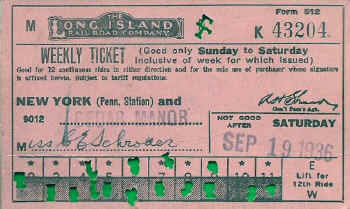
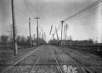
LIRR Weekly Ticket - NY Penn to Cedar Manor
9/11/1936 Archive: Brad Phillips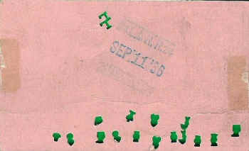 |
|
View south along the Long Island Electric Railway’s line in New
York Ave (then New York Blvd and now Guy R Brewer Blvd) at the crossing of the
the “Old Southern Division,” aka the Montauk Branch, aka today’s Atlantic
Branch, just east of the Cedar Manor station. Note the facing point derail on
the west rail of the southbound trolley track. That was controlled,
undoubtedly, by the crossing watchman in that little cabin by the tracks. Four
years later, in 1918, the railroad built “NA” Tower in that spot to control the
trolley crossing, complete with home signals. Note also the switch points in
the right foreground that led to the LI Electric’s car barns and storage yard.
Research: Jeff Erlitz Archive: NY Transit Museum |
|
|
|
|
|
LOCUST MANOR
|
|
LOCUST AVENUE: S. SIDE R.R. SVC.
BEGAN: 10/28/1867. DEPOT OPENED: 6/1869 (2-Year gap?) S. SIDE
OF TRACKS AND WEST SIDE OF LOCUST AVE. CROSSING. LISTED WITH BOTH NAMES
ON TIMETABLES. 2ND WOODEN DEPOT BLDG. WITH LOW-LEVEL
PLATFORMS IN SVC: 1898 (Per Robert Emery). N. SIDE OF TRACKS AND WEST
SIDE OF LOCUST AVE. CROSSING. WESTBOUND, COVERED, HIGH-LEVEL WOODEN AND
EASTBOUND, OPEN, LOW-LEVEL CINDER PLATFORMS, EAST OF DEPOT AND CROSSING TO
ACCOMMODATE JAMAICA RACETRACK IN SVC: 1906 (TRACK OPENED IN 1903).
NO AGENCY AS OF 01/01/1924. SHELTER SHED ADJACENT TO AND NEARLY TOUCHING DEPOT
BLDG ERECTED: 1927. STATION RENAMED “LOCUST MANOR”: 1929. Research: Dave
Keller |
_small.jpg) |
Looking southeast we see the original South Side Railroad
of LI Locust Avenue depot at the southwest quadrant of the Locust Avenue (now
Baisley Blvd) crossing in Locust Manor as it appeared in 1898, the year it was
demolished and replaced by a wooden frame depot at the northwest quadrant of
the Locust Ave. crossing. The photographer's wife is posed on the
platform. Research: Dave Keller (Wm. Murray photo, Queens Library digital
archive)
|
|
%20-%201898%20(Wm.%20Murray-Gary%20Sherlag)_small.jpg) |
Looking due east at Locust Manor in 1898, a westbound
two-car train is about to pass over the Locust Avenue crossing. The
original South Side Railroad of LI Locust Avenue depot is at the far right.
Research: Dave Keller (Wm. Murray photo, Queens Library digital archive)
|
|
|
LOCUST MANOR: FORMERLY ?LOCUST
AVENUE? OR ?RACETRACK? STATION. RENAMED: 1929. HIGH-LEVEL, WOODEN, COVERED
PLATFORM EXTENDED EASTWARD TO ACCOMMODATE TWO, 10-CAR, RACE TRAINS: 1947. HIGH
LEVEL PLATFORM AND REGULAR PASSENGER STATION OUT OF SVC: 1/28/59 WITH GRADE
ELIMINATION PROJECT AND RAZED. ELEVATED STRUCTURE IN SVC: 1959. AGENCY CLOSED:
? Research: Dave Keller |
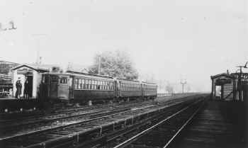
We're looking northeast in this c. 1936 view of the Locust Manor station. Originally opened as a station stop known as "Locust Avenue" by the South Side Railroad of LI in 1867, the depot was replaced in 1898. A wooden shelter-shed was added adjacent to the east side of the little depot building in 1927, as can be seen in this image. The stop was renamed "Locust Manor" in 1929. This was the station stop for the Jamaica Racetrack starting back in 1906. In the distance is an MU electric train stopped at the high-level racetrack station platform installed in 1947 to accommodate two 10-car race trains. The station was taken out of service on January 28, 1959 with the grade elimination project. (Dave Keller archive)
|
This is a close-up of the previous image showing the MU electric race train stopped at the high-level racetrack platform. (Dave Keller archive)
|

A MU electric race train is stopped at the wooden, high-level station platform at the Jamaica Racetrack station at Locust Manor in 1944. This view is looking east. (Unidentified photographer and archive)
|
Looking west in 1959, the newly-elevated tracks are visible at the right and the older tracks and high and low platforms for the Jamaica Racetrack are visible at the left. At the far left is the grandstand of the racetrack. (W. J. Edwards photo, Dave Keller archive)
|
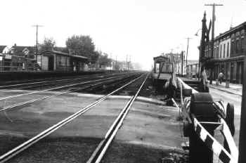
Looking west along the eastbound station platform at Locust Manor, we see the elevated station facilities as they appeared on a cold, snowy February 21, 1977. (Jeffrey Erlitz photo, Dave Keller archive)
|
Looking northwest on March 30, 1921, we see "Springfield Shed B," one of four "Springfield Sheds" that were constructed on the north side of the tracks east of the then-named Locust Avenue station. Made of corrugated sheet metal, they were erected in 1904-05 and were 900 feet long. When the LIRR received their first fleet of MP41 MU electric cars, they were brought here to have their electric motors installed in 1905-06. The sheds were razed c. 1937 and the tracks removed sometime later. (LIRR Valuation photo, Dave Keller archive)
|
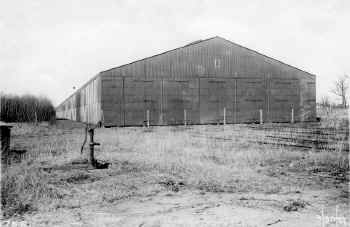
Also looking northwest on the same day, we see "Springfield Shed D." Note the old hand-pump in the foreground. After the sheds no longer were needed for installation of the electric motors on the MP41 cars, they were used to store extra MP41 motor cars and trailers that were not needed on the winter timetable. (LIRR Valuation photo, David Morrison archive)
|
Looking west just east of Locust Manor station on June 25, 1937 we see the main tracks at grade at the far left, the access track in the center and the storage tracks that once entered "Springfield Shed D." The sheds were razed earlier that year. (Dave Keller archive)
|
Locust Manor - View E 8/31/1958 |
|
HIGBIE AVENUE
|
HIGBIE AVENUE STATION: OPENED: 1908 AS ?SPRINGFIELD?, RENAMED: 9/1927.
PART TIME AGENCY STILL LISTED IN "L.I.R.R. TICKET OFFICES OPEN FOR SALE OF TICKETS" OF 9/12/55.
AGENCY CLOSED SOMETIME IN 1956. REPLACED WITH TEMPORARY STATION IN 1958 DUE TO GRADE ELIMINATION PROJECT.
OLD DEPOT RAZED LATE 1958-EARLY 1959. TEMPORARY STATION OUT OF SVC: 2/2/60 WITH COMPLETION OF GRADE ELIMINATION
PROJECT AND DISCONTINUED AS STATION STOP.
|
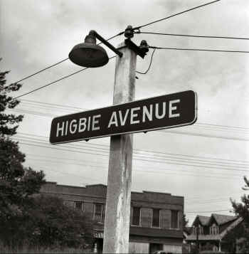
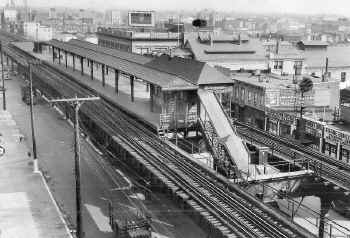
This is the old platform lamp with station sign for the Higbie Avenue station in Laurelton on August 31, 1957. (Will V. Faxon, Jr. photo, Dave Keller archive)
|
Higbie Avenue station in Laurelton is viewed looking NE on August 31, 1957. Opened in 1908 as "Springfield", it was renamed in September, 1927. The ticket agency eventually became part-time and then the agency closed sometime after 1956. The old depot was demolished in late 1958-early 1959. The temporary station was taken out of service on February 2, 1960 with completion of the grade elimination and the station stop discontinued. (Will V. Faxon, Jr. photo, Dave Keller archive)
|
The grade elimination project is underway at the Higbie Avenue station in this view photographed on August 16, 1958. Looking northeast from the temporary station platform, the freshly-ballasted, temporary tracks with mid-track fence are in the foreground, the temporary wooden shelter is on the westbound platform. The old depot is in the left background and the old wooden shelter-shed in the center of this image is in the process of being torn down. (Will V. Faxon, Jr. photo, Dave Keller archive)
|
An MU electric train is eastbound over the 141st Street crossing at Higbie Avenue station, Laurelton in this eastward view taken on August 31, 1957. The crossing shanty is at the right and the crossing watchman has manually cranked down the gates. The mid-track fence at the left indicates the extent of the Higbie Avenue station facilities. (Will V. Faxon, Jr. photo, Dave Keller archive)
|
Another MU train is approaching the temporary Higbie Ave. station via the temporary tracks in place for the upcoming grade elimination project. At the right are the former main tracks as viewed westward on August 15, 1958. (Will V. Faxon, Jr. photo, Dave Keller archive)
|
An MU train is eastbound leaving the temporary station at Higbie Avenue on August 16, 1958. This view is looking west. Note at the far right the old diamond crossing sign still in use. (Will V. Faxon, Jr. photo, Dave Keller archive)
|
|
|
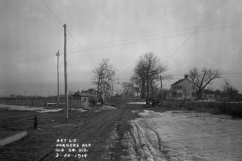
View S along Farmers Avenue (now Blvd), just west of the Higbie Avenue Station.
3/20/1914 Archive: NY Transit Museum |
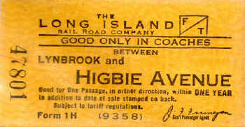
Ticket - Lynbrook to Higbie Ave c.1948+ Archive: Brad Phillips |
|
LAURELTON |
|
LAURELTON STATION:
OPENED: 1908 AS ?SPRINGFIELD?, RENAMED: 9/1927. PART TIME AGENCY STILL LISTED IN "L.I.R.R. TICKET OFFICES OPEN FOR SALE
OF TICKETS" OF 9/12/55. AGENCY CLOSED SOMETIME IN 1956. REPLACED WITH TEMPORARY STATION IN 1958 DUE TO GRADE ELIMINATION PROJECT.
OLD DEPOT RAZED LATE 1958-EARLY 1959.
TEMPORARY STATION OUT OF SVC: 2/2/60 WITH COMPLETION OF GRADE ELIMINATION PROJECT AND DISCONTINUED AS STATION STOP.
|
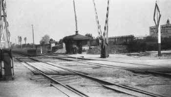
"SR" interlocking cabin was located west of Laurelton, and is seen here in this 1923 view looking east, at the planked crossing of Springfield Boulevard. Someone fond of gardening has what looks like ivy covering the entire trackside wall and roof portion of the cabin with other growth on the crossing side. Placed in service in 1912, the cabin also served as the crossing shanty and when the block office was taken out of service in 1923, the building remained in place for continued use as a crossing shanty, lasting until the grade elimination project removed the crossing. (James V. Osborne photo, Dave Keller archive)
|
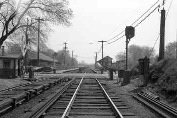
This is the old Laurelton station when at grade, back on April 30, 1946. This depot, built in 1907, had beautiful landscaping. Sadly, it was razed in 1950 due to the grade elimination project. This terrific view shows the landscaped depot at the left and the wooden shelter shed at the right. The crossing shanty with crossing watchman are at the far left. The gates have been manually lowered. The elevated station that replaced this old depot was opened in October-November, 1950. The ticket agency closed on December 10, 1996. (Frederick Weber photo, David Morrison archive)
|
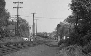
In the distance of this c. 1950 image we see an MU train westbound leaving the now-elevated Laurelton station. The train is coming down off the elevated embankment as it approaches the Springfield Blvd. crossing. (Dave Keller archive)
|
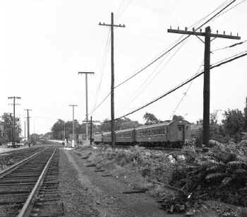
Looking west, an eastbound MU train is on the temporary tracks over the Springfield Blvd. crossing as it begins to climb the grade towards the already-elevated Laurelton station during the grade elimination project through Higbie Avenue station on August 16, 1958. (Will V. Faxon, Jr. photo, Dave Keller archive)
|
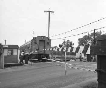
A westbound MU electric train is about to make the crossing of Springfield Blvd. on August 16, 1958. This view is looking southeast with the crossing shanty at the left. These gates were manually operated by the watchman who is leaning on one of them and waving to the motorman who in turn is waving back. (Will V. Faxon, Jr. photo, Dave Keller archive)
|
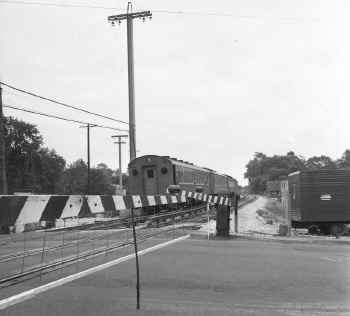
Looking in the opposite direction at Springfield Blvd., a westbound MU electric train is approaching the crossing. The wires and suspended white lower bar on the gates was designed to keep pedestrians from ducking under the gates and car hoods from jutting dangerously too far into the path of oncoming trains. (Will V. Faxon, Jr. photo, Dave Keller archive)
|
|
|
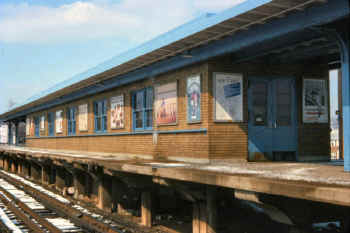
This is the elevated station at Laurelton which opened in October-November, 1950, replacing the old, beautifully landscaped depot at-grade. The agency closed on December 10, 1996. (Jeffrey B. Erlitz photo, Dave Keller archive)
|
|
|
SPRINGFIELD JUNCTION
|
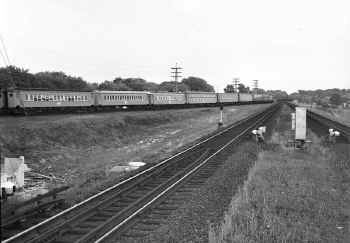
Looking east from the eastern end of the Laurelton station on August 31, 1957, we see an MU electric train on the Springfield branch, approaching Springfield Junction east of Laurelton and west of Rosedale stations. (Will V. Faxon, Jr. photo, Dave Keller archive)
|
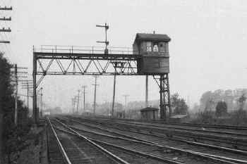
"SP" tower at Springfield Junction, constructed on a signal bridge west of Foster's Meadow Road, west of Rosedale station, controlled the junction of the LIRR's Atlantic branch with the Springfield/Montauk branch. It was placed in service on May 12, 1906. This view is looking west. It was taken out of service on September 10, 1923, shortly after this image was photographed that same year. (James V. Osborne photo, Dave Keller archive)
|
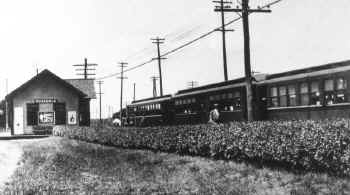
An MP41 MU electric "sandwich" train is seen here at the Rosedale station looking west c. 1910. The train consisted of a MU motor car on each side of a wooden, center-door trailer car sandwiched between. Rosedale station was originally a South Side Railroad of LI station stop, in service on October 28, 1867 as "Foster's Meadow." The original depot was replaced in 1889 by this structure and the original depot possibly used as the freight house, which was done on several occasions on the LIRR. The stop was renamed "Rosedale" in 1892 and the depot was razed in November, 1948 in the grade elimination project. (Dave Keller archive)
|
|
ROSEDALE
|
ROSEDALE STATION: SOUTH SIDE R. R.
SERVICE BEGAN: 10/28/1867 AS FOSTER'S MEADOW.? DEPOT BUILT: 7/1871 (4-year
gap?)
OUT OF SVC: 1889. MAY HAVE BEEN USED AS FREIGHT HOUSE FOR SECOND DEPOT. RAZED: ?
2ND DEPOT BUILT: 1889. RENAMED ?ROSEDALE?: 1892. EASTBOUND FACILITIES RELOCATED SOUTH OF FORMER LOCATION: 11/26/41.
RELOCATED NORTH AGAIN: 3/10/42 WITH CANCELLATION OF PROJECT.
ALL FACILITIES AGAIN RELOCATED SOUTH OF FORMER LOCATION: 11/16-18/48 DUE TO GRADE ELIMINATION PROJECT.
DEPOT RAZED: 11/48. TEMPORARY FACILITIES IN SERVICE SOUTH OF FORMER LOCATION: 11/16-18/48
ELEVATED STRUCTURE OPENED WESTBOUND: 10/31/50, EASTBOUND: 11/27/50. AGENCY CLOSED: 8/19/2009.
|
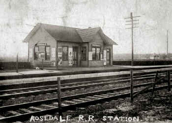
This old photo looking southwest shows the Rosedale station c. 1920. The depot building is covered with ad posters, which was very typical of advertising at the time. (Unidentified photographer and archive
|
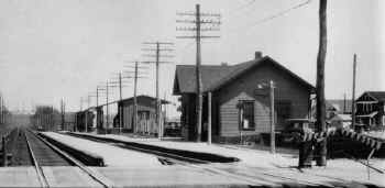
Looking southeast on April 14, 1931, we see the Rosedale station, freight
house and express house in the distance. Originally a South Side Rail Road
station stop, the original depot may have been used as the freight house for
this 1889 replacement depot. The architecture is of the style used by the SSRR,
with a high level platform and overhead canopy added to accommodate freight
handling. (Unidentified photographer and archive)
|
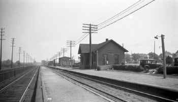
This is a similar view of the Rosedale station shot five years later in
1936. View is east. (Dave Keller archive)
|
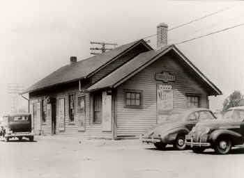
Here is a rear view of the Rosedale station looking northwest during the summer of 1941. A theatre poster on the east wall advertises the production of "Native Son" starring Orson
Welles. The show ran from March to June of 1941 at the St. James Theatre in N. Y. City. (Unidentified photographer and archive)
|
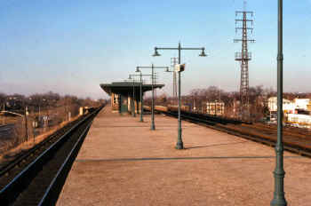
Looking west, this is the elevated station at Rosedale, which replaced the old depot at-grade. It opened in October-November, 1950. The agency closed on August 19, 2009. (Wm. Madden photo, Dave Keller archive)
|
|
|
VALLEY STREAM
|
VALLEY STREAM STATION: SOUTH SIDE R. R.
SERVICE BEGAN 10/28/1867. DEPOT OPENED: 7/1869 WITH OPENING OF BRANCH TO FAR ROCKAWAY.
BUILT INSIDE LEGS OF WYE.
2ND DEPOT BUILT AT SAME LOCATION OR ORIGINAL DEPOT REMODELED: c. 1881
OUT OF SERVICE: 8/10/32 ACCOUNT GRADE CROSSING ELIMINATION PROJECT. RAZED: 1933.
TEMPORARY STATION RELOCATED ON SHOO-FLY NORTH OF FORMER LOCATION IN SERVICE: 8/10/32
TRACKS AND STATION PLATFORMS ON FAR ROCKAWAY BRANCH OUT OF SVC: 8/31/32.
ELEVATED TEMPORARY TRACKS AND PLATFORMS ON FAR ROCKAWAY BRANCH IN SERVICE: 2/07/33
3RD, ELEVATED, CENTER-ISLAND STRUCTURE NORTH OF FORMER LOCATION IN SVC: 6/27/33.
ELEVATED JCT. OF WEST HEMPSTEAD BRANCH IN SVC: 9/10/33
|
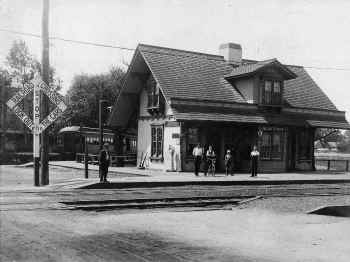
This is Valley Stream station at-grade, photographed c. 1910. Looking southwest, we see the diamond crossing sign at the left and in the background, a train of wooden coaches on the east leg of the wye track accessing the Far Rockaway branch. The depot was constructed inside the legs of the wye track. A short distance east of the depot was the junction of the West Hempstead branch. (Unidentified photographer and archive)
|
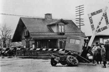
Almost shot at the same angle as the previous image, but in 1924, we see the aftermath of a train-versus-truck confrontation. The truck was pushed into the diamond crossing sign. Crossing gates have been installed at the time of this photo, but it appears the truck driver had different ideas about stopping. In the right background, adjacent to the depot, an express house has been added since the previous, earlier view. (Unidentified photographer, Ron Ziel archive)
|
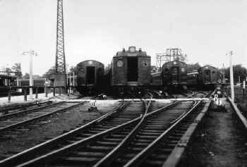
Here we see the old MU layup yard south of the Valley Stream station when
it was at-grade. This view looking north was photographed on 09/14/32. To the far left was the curved station platform and Far Rockaway branch track. The grade crossing elimination project through here would begin the following month. (Dave Keller archive)
|
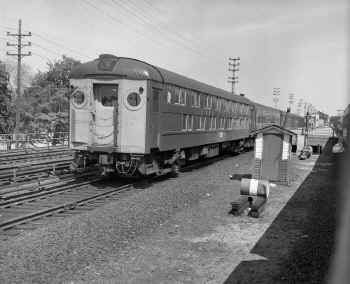
A westbound train pulled by a MU double-decker electric motor is leaving the elevated station at Valley Stream in this northeast view taken on June 2, 1962. The elevated station facilities were opened on June 27, 1933. (Will V. Faxon, Jr. photo, Dave Keller archive)
|
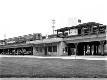
A two-car MU electric train with banner on the 2nd car advertising the LIRR's "Ladies Day" special is eastbound on the Atlantic branch track at the elevated Valley Stream station in this 1967 view looking northwest. Being a two-car train, it most probably is bound for West Hempstead. After leaving the station, it will hit the crossover tracks just beyond "VALLEY" interlocking tower and head up the West Hempstead branch. The white tower at platform level is the old baggage/express elevator shaft, which was used to transport items from the ground-level ticket office to platform level. (Dave Keller photo and archive)
|
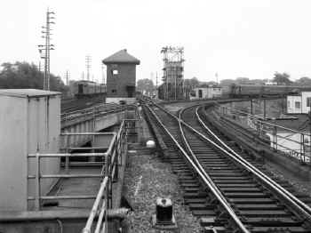
The Atlantic branch ends at Valley Stream station. The tracks then continue further east, becoming the Long Beach branch and head to Lynbrook where they curve off and head to Long Beach. The Far Rockaway branch
leaves the Atlantic branch at Valley Stream, curving off to Far Rockaway. Controlling all this plus the previously-mentioned West Hempstead branch crossover switches and signals is "VALLEY" interlocking tower, seen here in this eastward view photographed on July 10, 1965 from the east end of the Valley Stream station platform. At the left is an MU electric train on the Montauk branch tracks, bypassing this center-island platform station. To the immediate right of the tower is an MU electric train on what now becomes the Long Beach branch and at the right are the two tracks of the Far Rockaway branch curving off from the Atlantic branch with a westbound MU electric train approaching the junction. Opened as "VA" tower on June 27, 1933 with completion of the grade elimination project, it was renamed "VALLEY" on April 30, 1937. (Harold A. Smith photo, Dave Keller archive)
|
|
Note (1) 5 mph due to the curves in the
station and the switches placed in risky locations. Clearances are indeed
tight. In the years prior to the M-1's only MP-54s could go to Brooklyn. This
gave the oldest cars to branches that traveled mostly to Brooklyn, like Far
Rockaway. When it became apparent that the M-1s would be the only cars
available, several of the structural walls in BROOK Interlocking were chiseled
away to make the necessary clearance for the longer cars. |
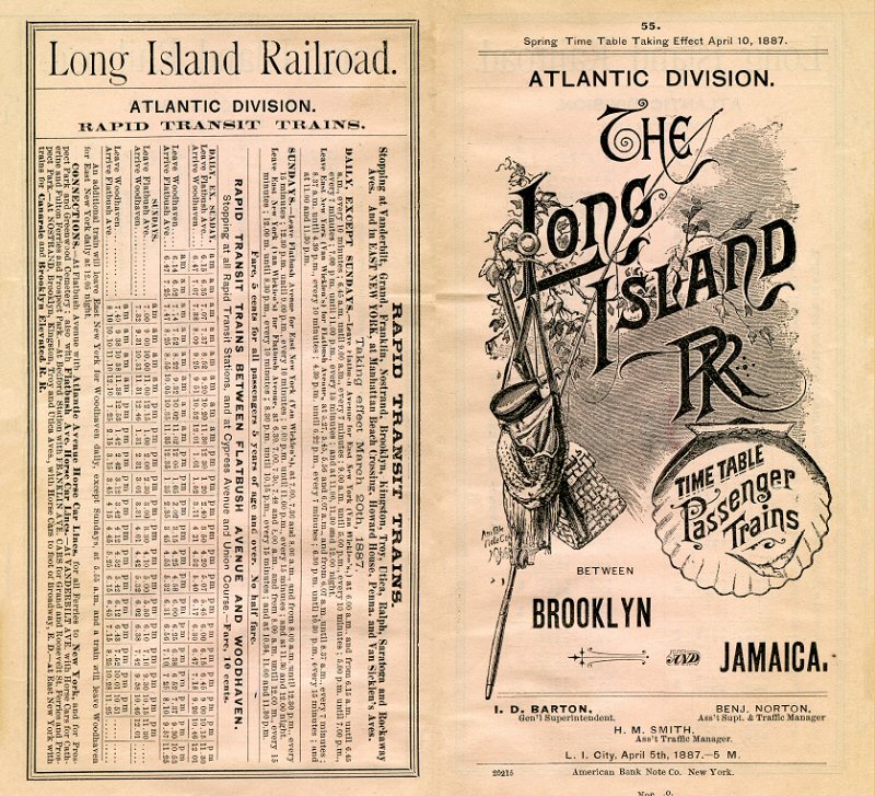
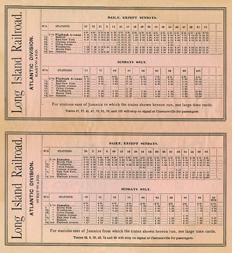
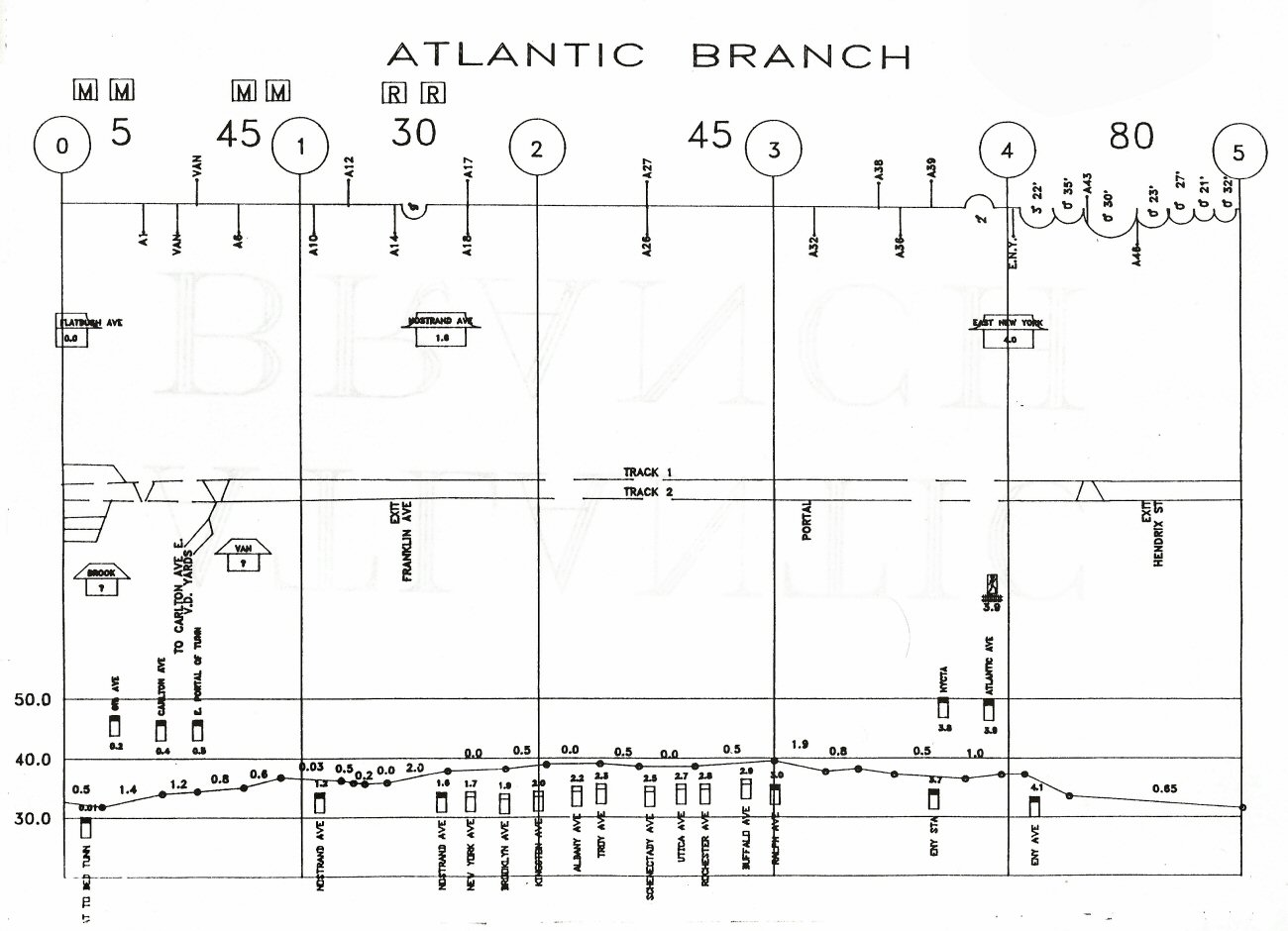
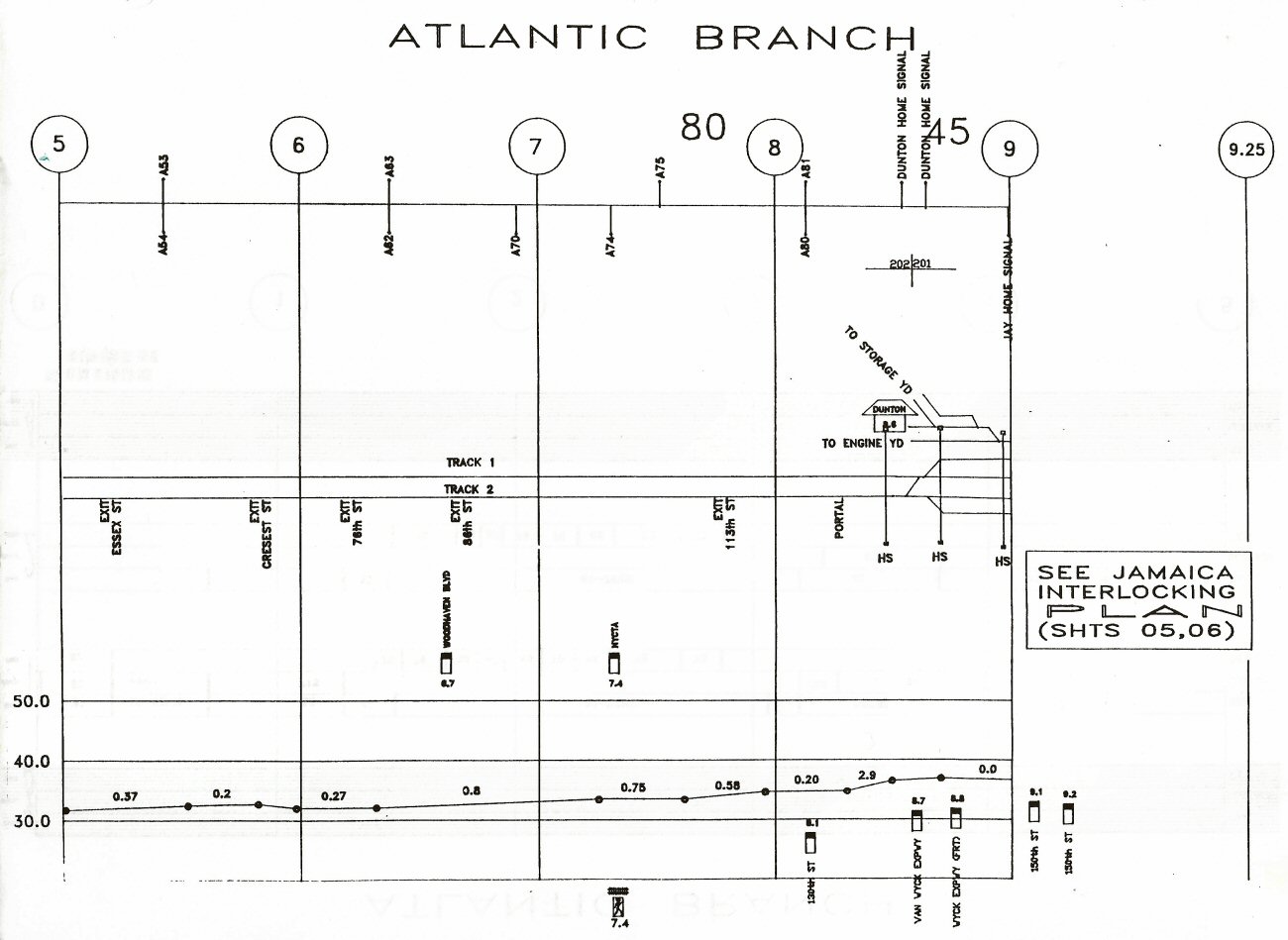
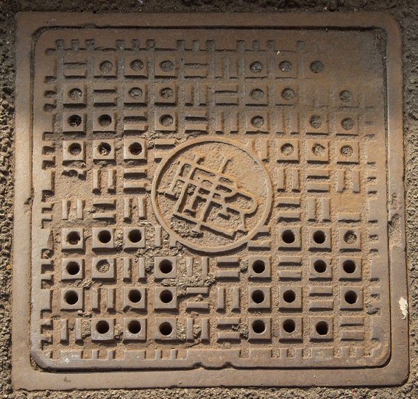


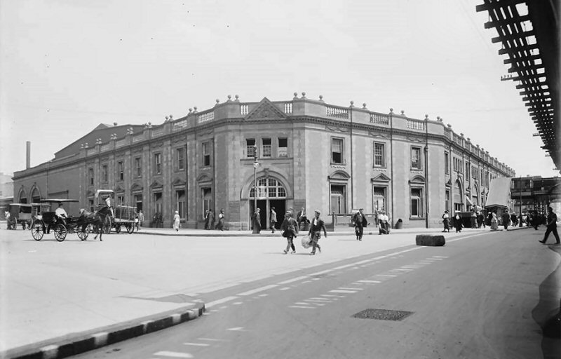
.jpg)
-Flatbush_Ave-Bklyn-10-13-78_(Madden-Keller).jpg)


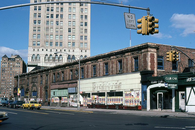

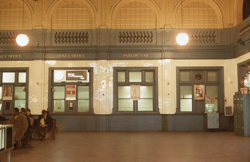
.jpg)
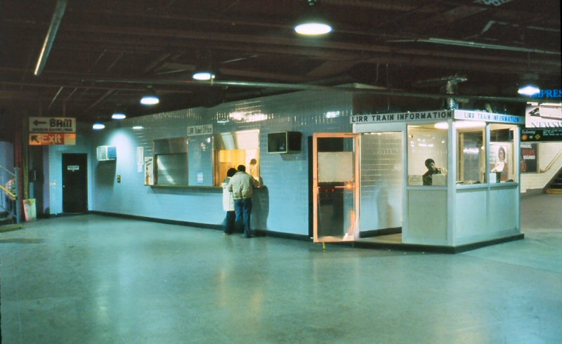
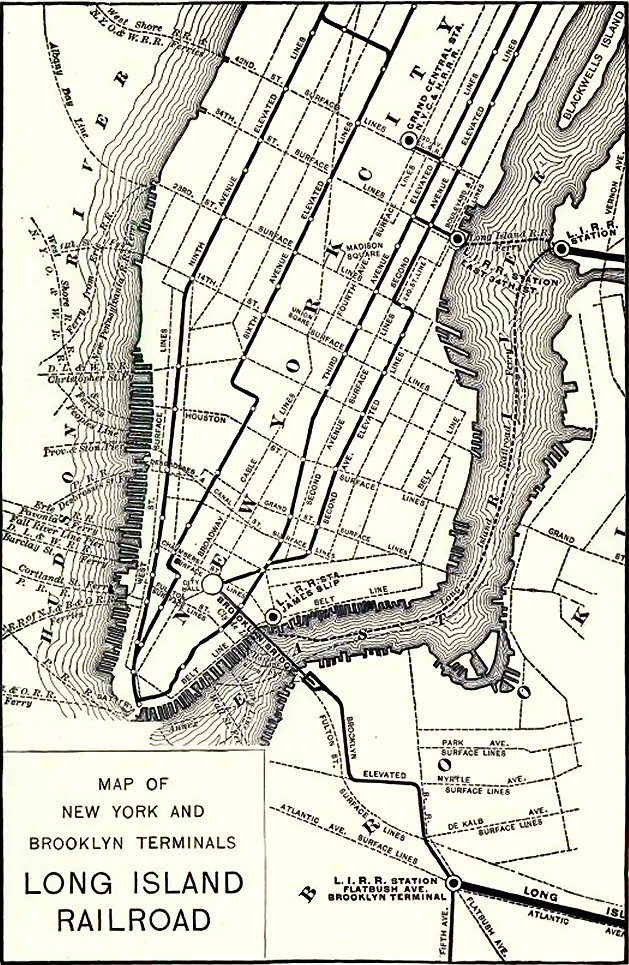
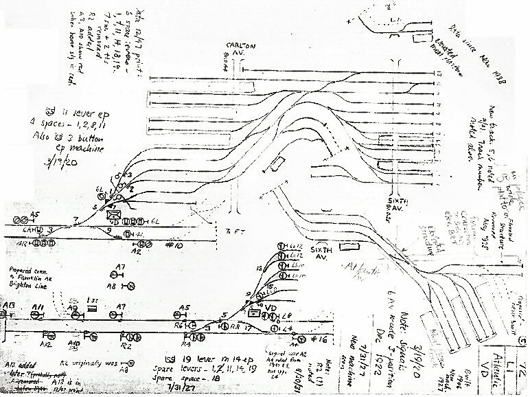


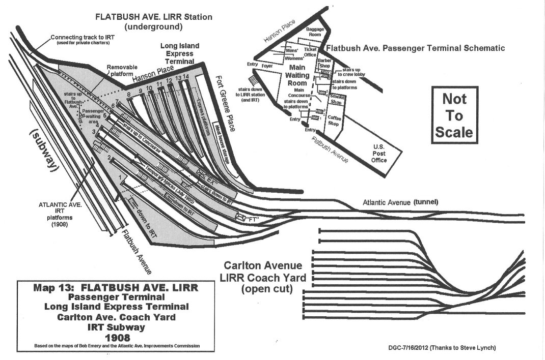
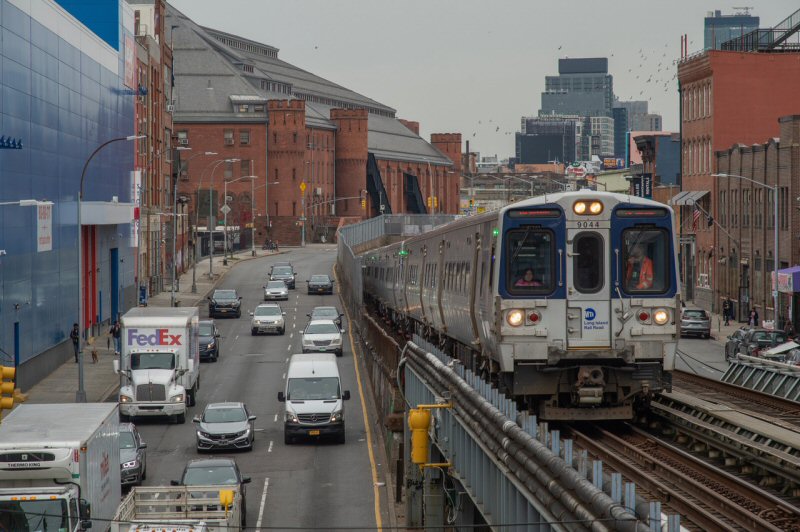
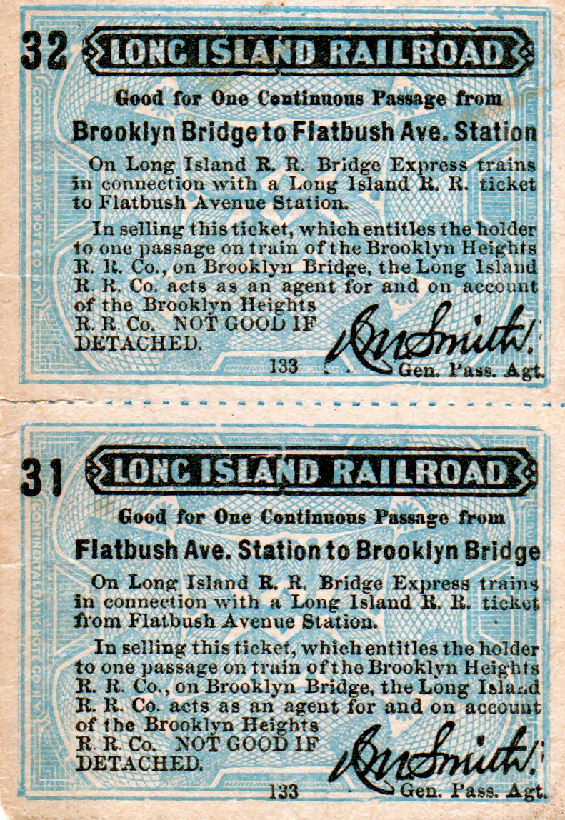
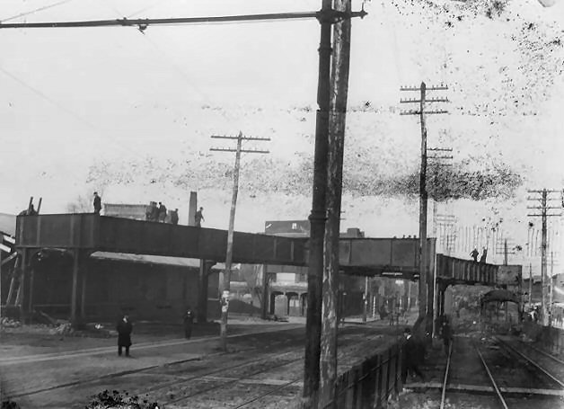


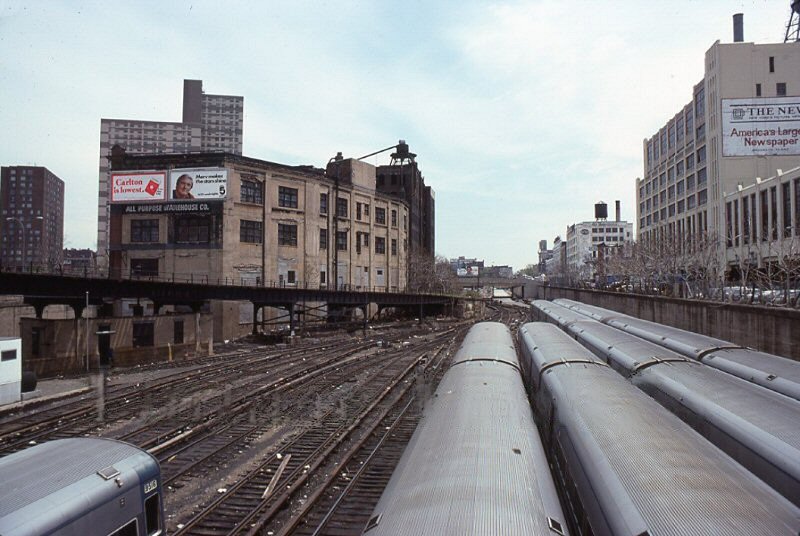

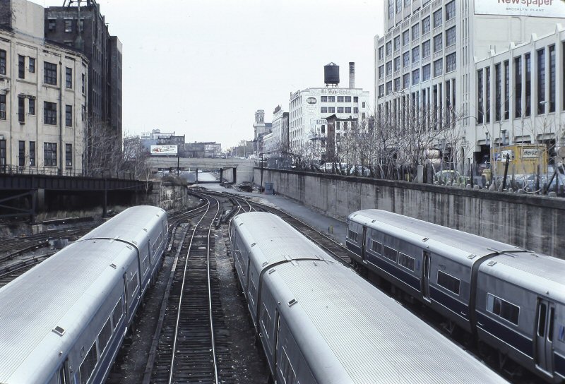

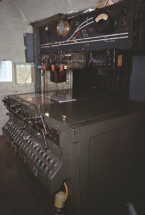
.JPG)
.JPG)
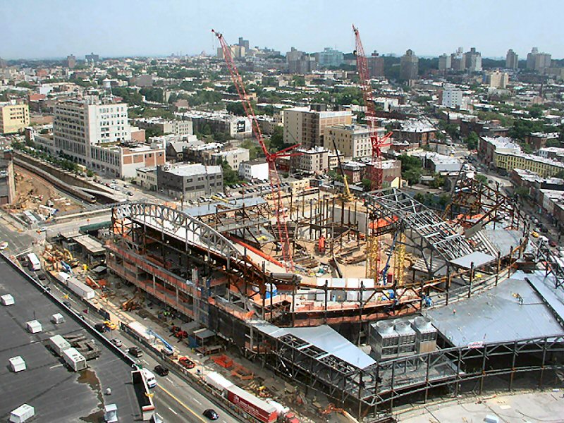
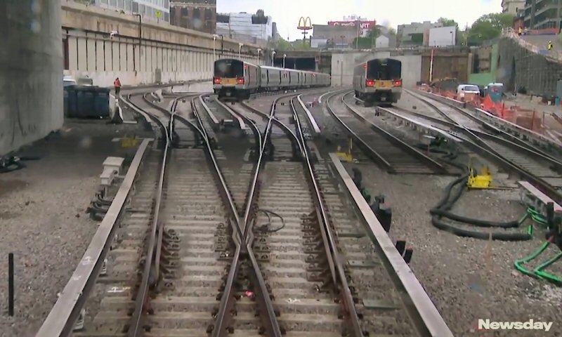
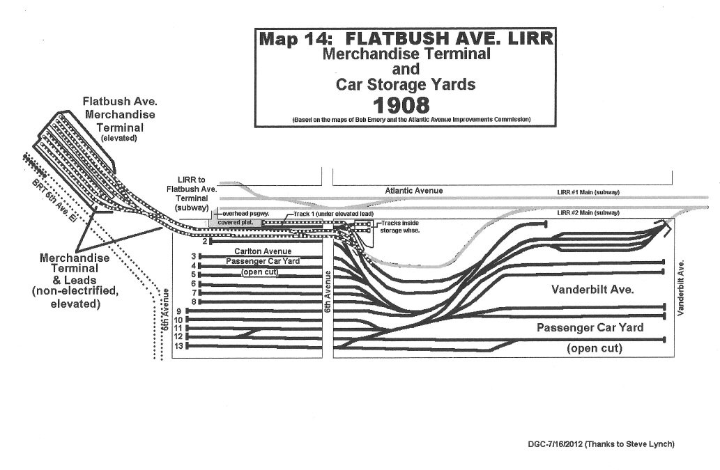
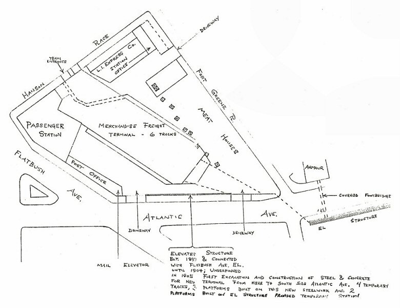
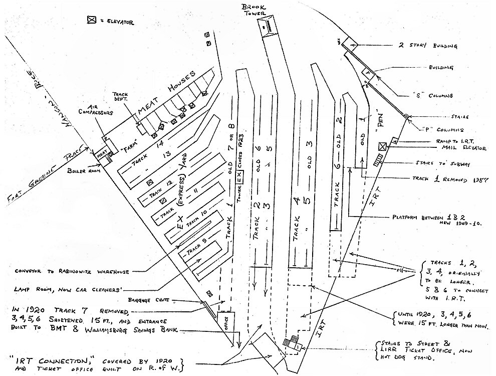
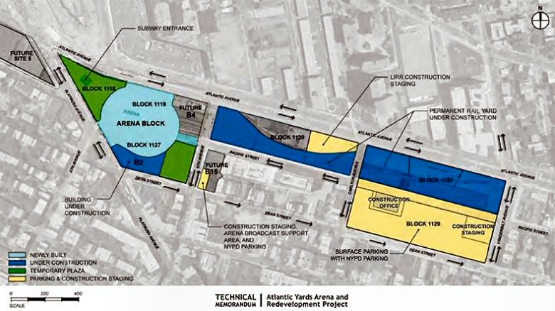

.jpg)
.jpg)
.jpg)
.jpg)
_1.jpg)
_2.jpg)
_3.jpg)
_4.jpg)
_5.jpg)
_6.jpg)
_7.jpg)


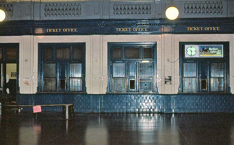
_8.jpg)
_9.jpg)
_10.jpg)
_11.jpg)
_12.jpg)
.jpg)
.jpg)
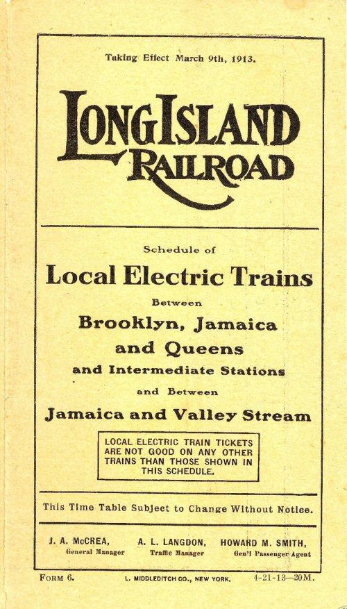
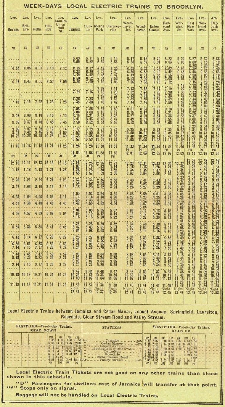
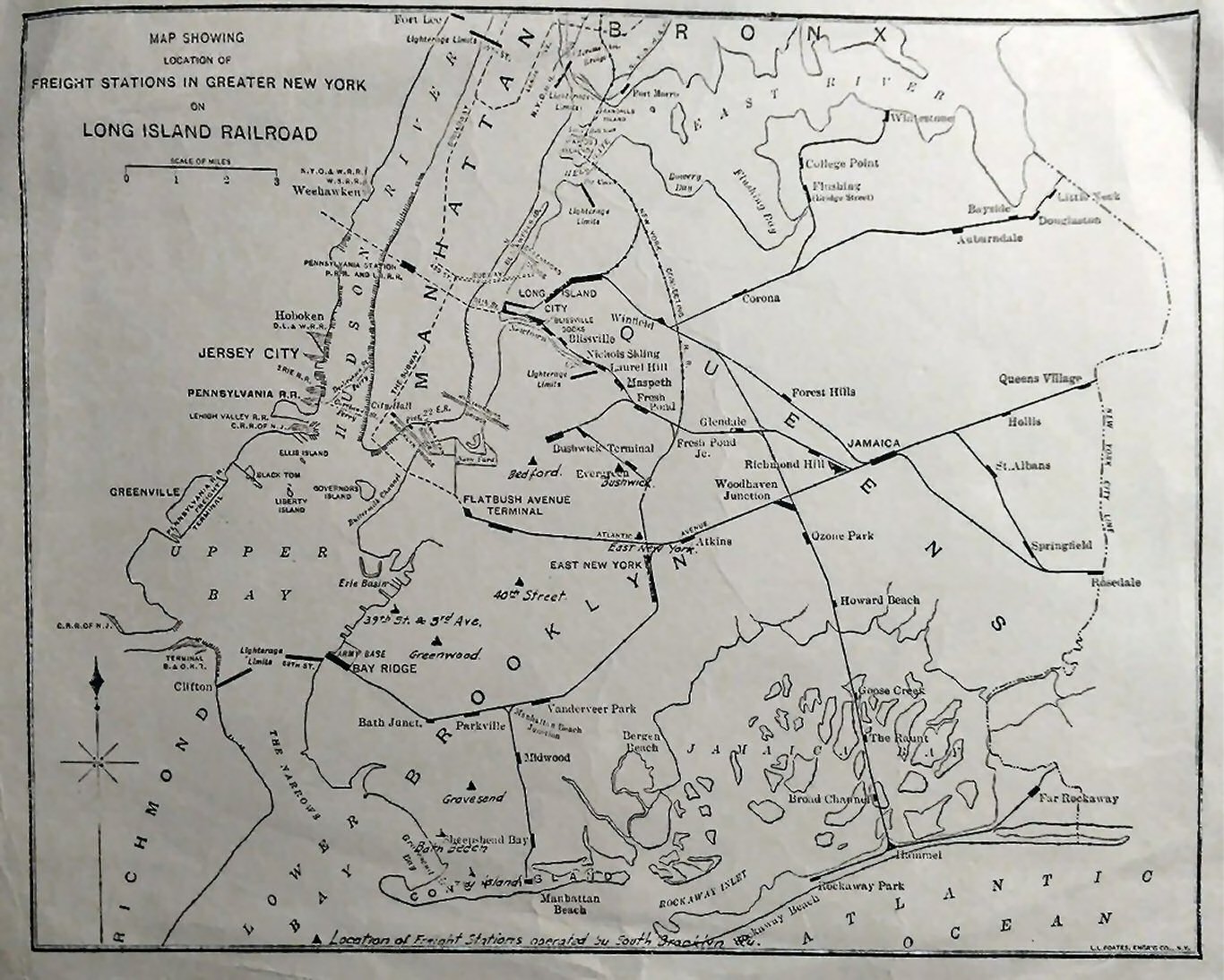
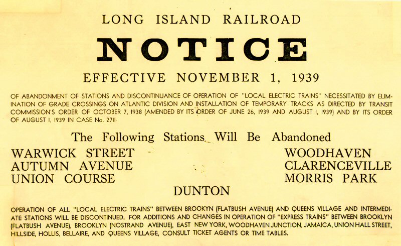
.jpg)
.jpg)
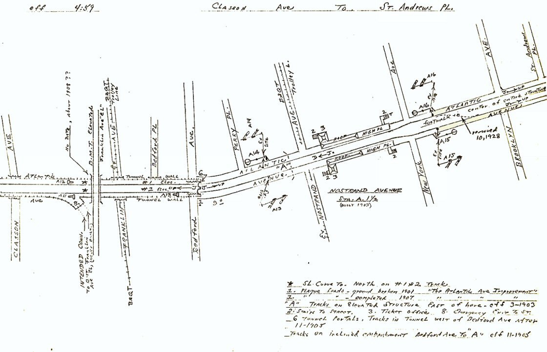
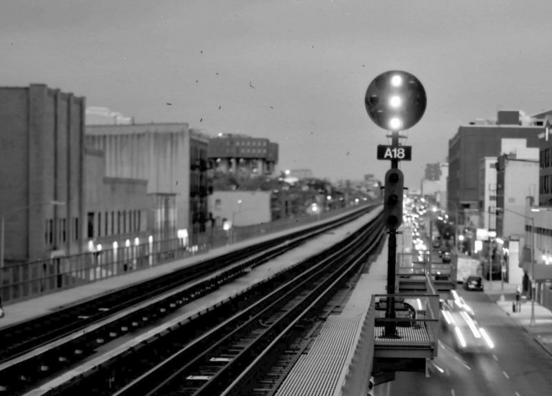
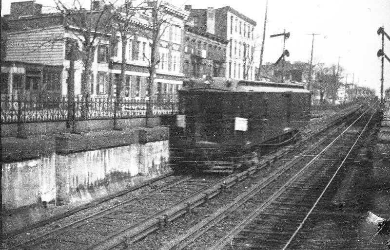
.jpg)
%20-%20c.%201920%20(Keller).jpg)
%20-%2011-01-70%20(Keller).jpg)
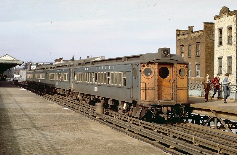
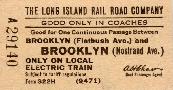
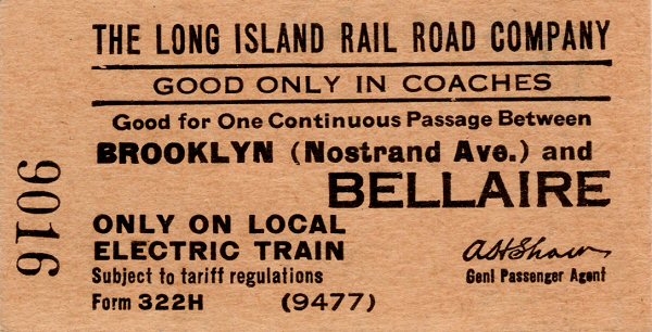
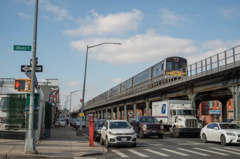
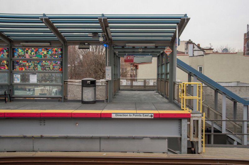
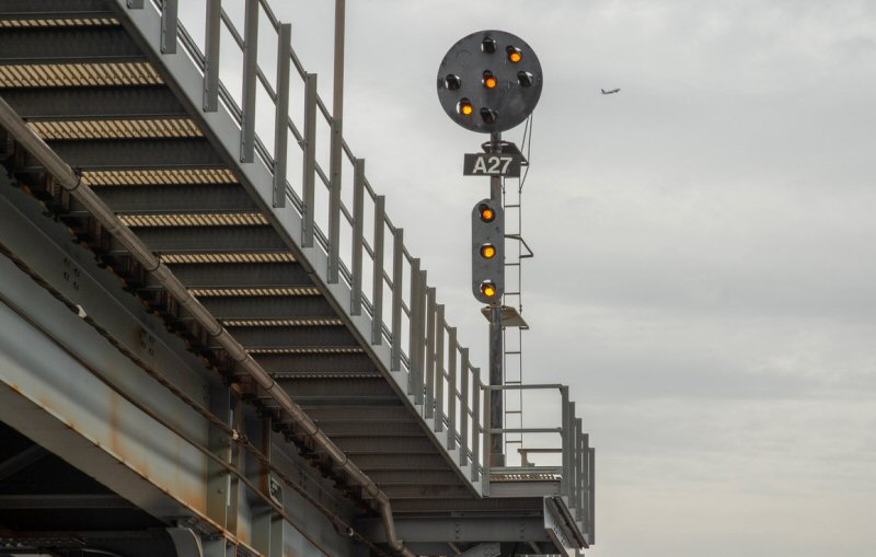
.jpg)
.jpg)
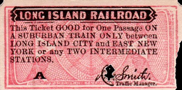
.jpg)
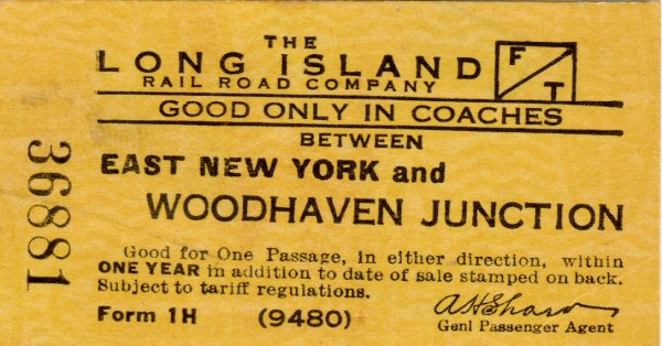
.jpg)
-East%20NY%20-%2002-18-1915%20(Keller).jpg)
%20-%20E%20NY%20-%201917%20(Keller).jpg)
.jpg)

%20-%2005-22-1916%20(Urquhart-Keller).jpg)
.jpg)
.jpg)
.jpg)
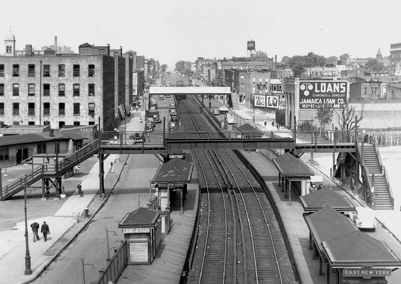
.jpg)


.JPG)
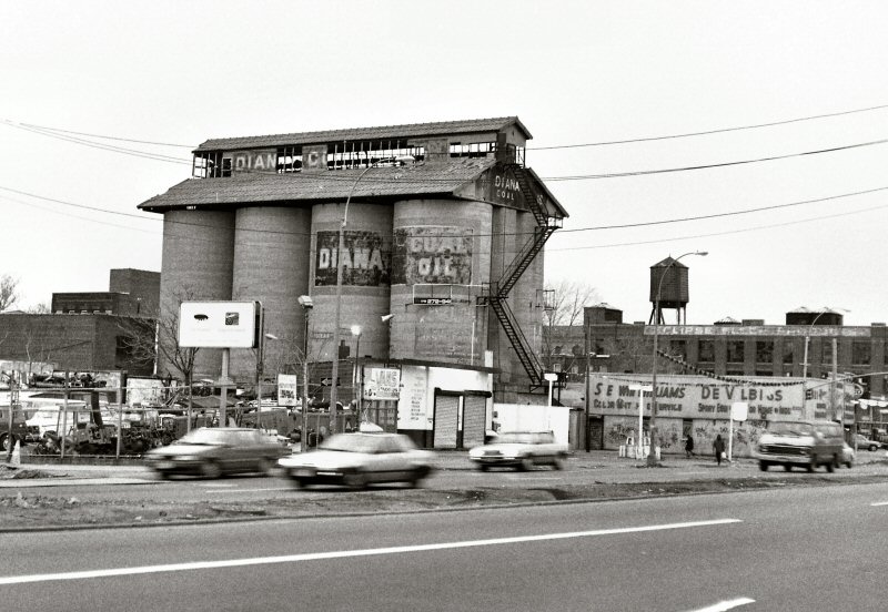

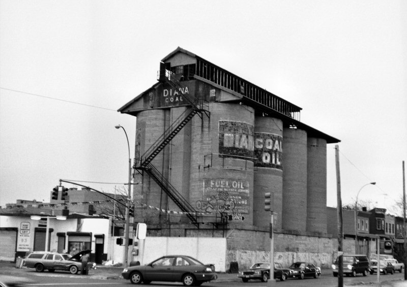
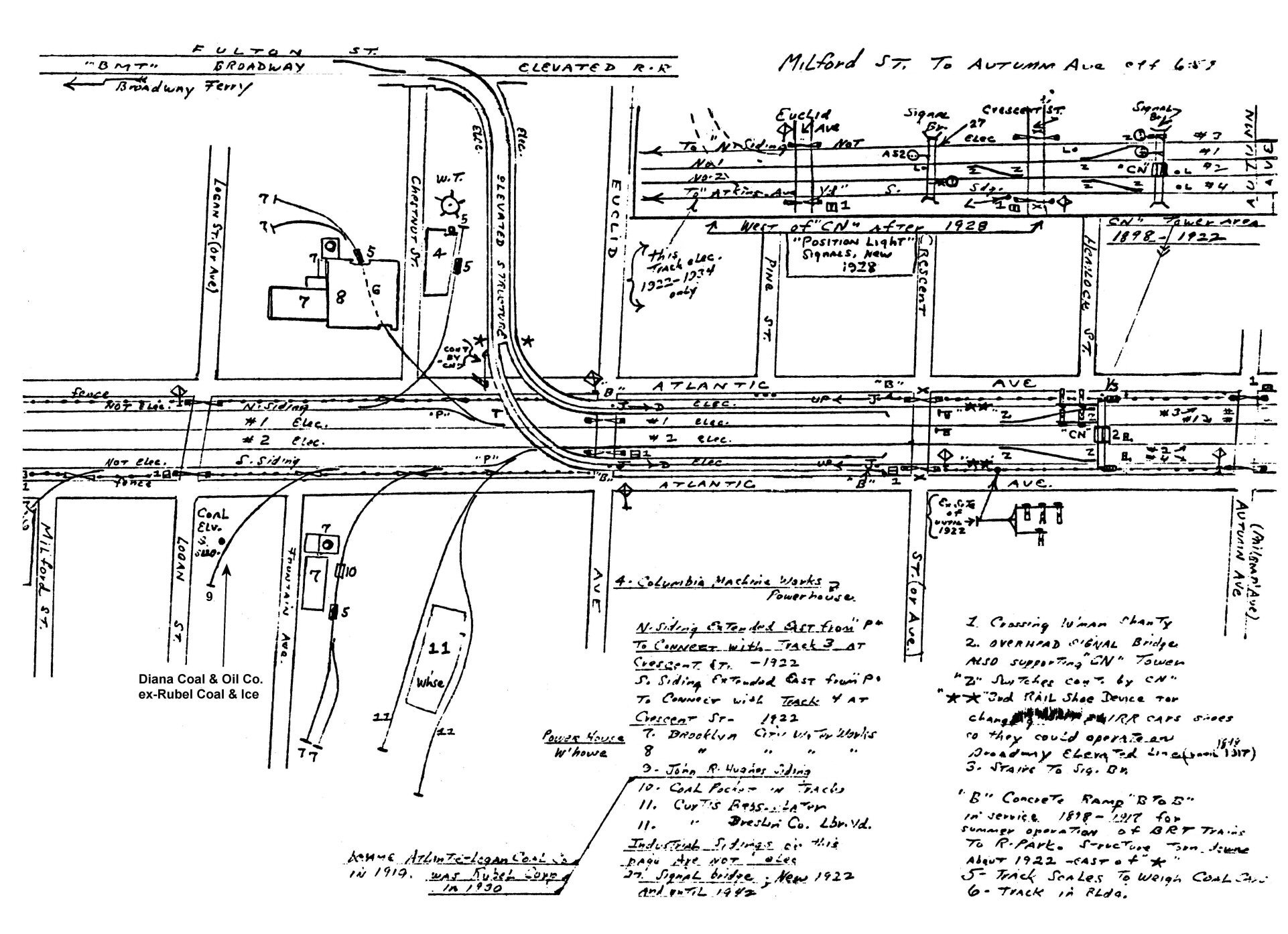
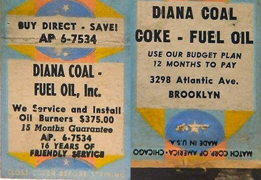
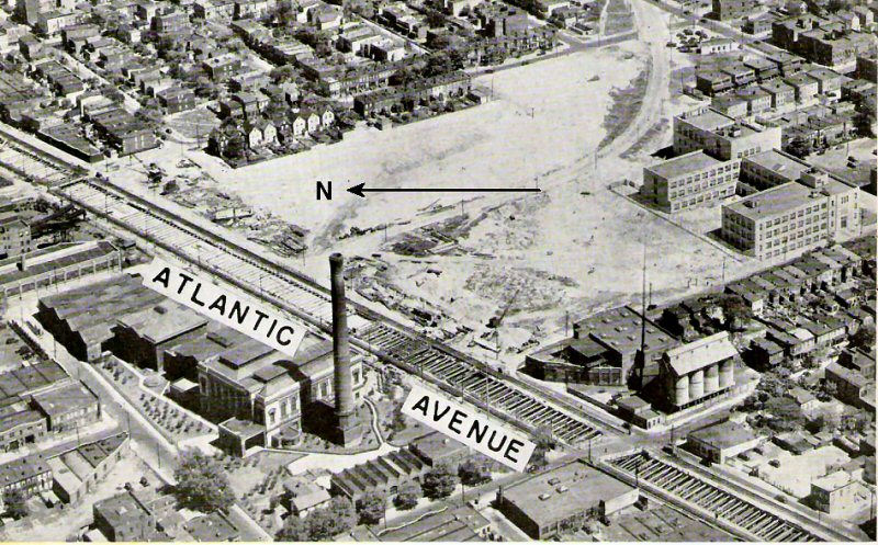
%20-%2007-27-1930%20(Sperr-Keller).jpg)
%20-%2007-27-1930%20(Sperr-Keller)%20(Zoom).jpg)
%20-%2007-27-1930%20(Sperr-Keller)%20(2).jpg)
%20-%2007-27-1930%20(Sperr-Keller).jpg)
%20-%2010-26-39%20(Keller).jpg)
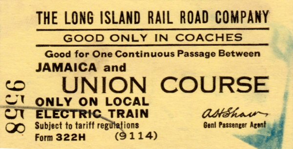
%20-%20c.%201925%20(Osborne-Keller).jpg)
%20-%2007-27-30%20(Sperr-Keller)%20(Zoom).jpg)
%20-%2007-27-30%20(Sperr-Keller).jpg)
.jpg)
%20(1).jpg)
%20(2).jpg)
.jpg)
%20-%2009-29-38%20(Keller).jpg)
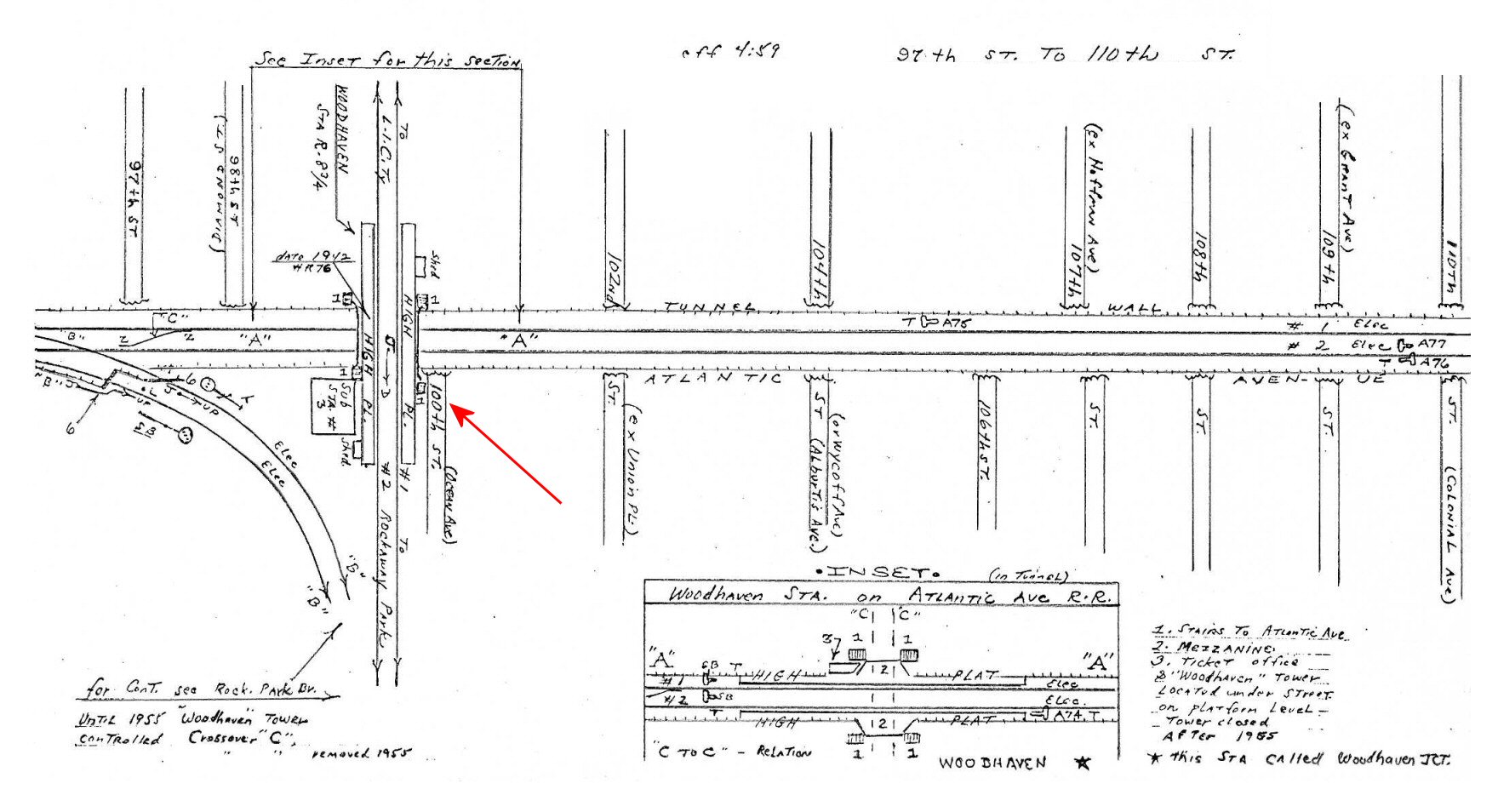
%20-%2009-29-38%20(Keller).jpg)
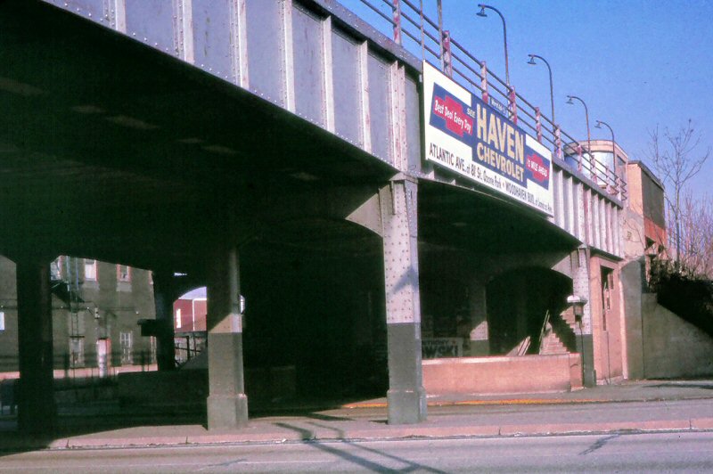


.jpg)
.jpg)
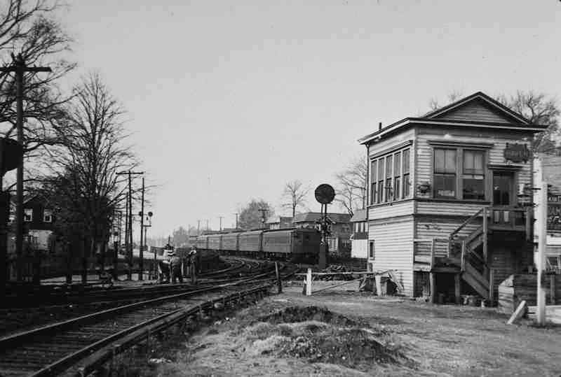
%20-%2004-03-1916%20(Keller).jpg)
.jpg)
%20-%2010-28-39%20(Keller).jpg)
.jpg)
%20-%2005-07-34%20(Sperr-Keller).jpg)
%20-%2007-27-2014%20(Bing%20Maps).jpg)
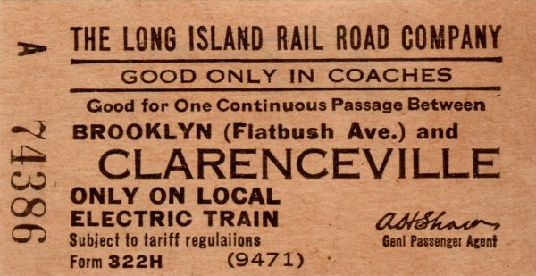
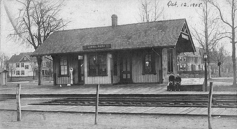


%20-%2005-07-34%20(P.%20Sperr-Keller).jpg)
%20-%2005-07-34%20(Sperr-Keller).jpg)
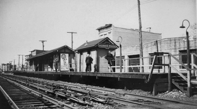
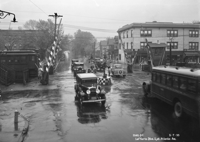
.JPG)
%20-%2009-07-38%20(Keller).jpg)
%20-%2010-26-39%20(Keller).jpg)
%20-%2012-29-1908%20(Keller).jpg)
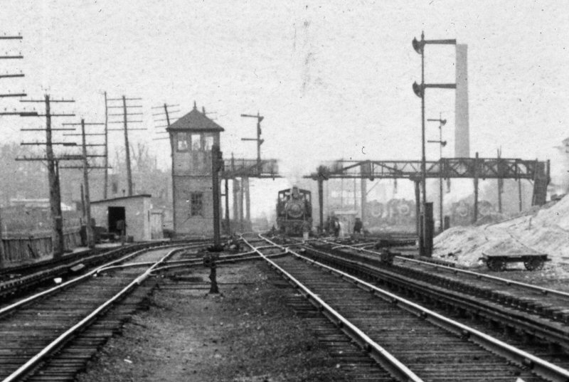
.jpg)
.jpg)
%20-%2001-14-1914%20(LIRR-Keller).jpg)
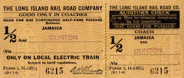
%20-%2007-02-39%20(Keller).jpg)
.jpg)
.jpg)
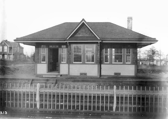
.jpg)
%20-%201923%20(Osborne-Keller).jpg)

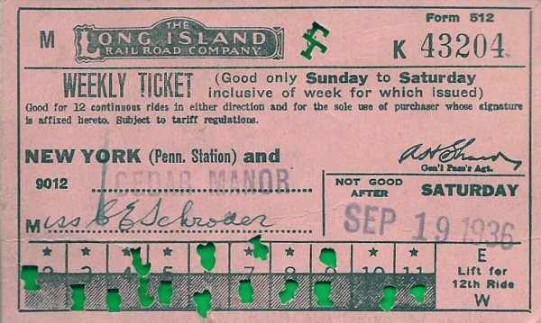
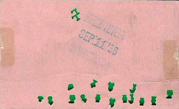
.jpg)
%20-%201898%20(Wm.%20Murray-Gary%20Sherlag).jpg)


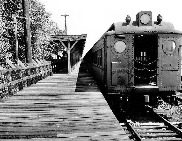
.jpg)
%20-%2002-21-77%20(Erlitz-Keller).jpg)
.jpg)
.jpg)

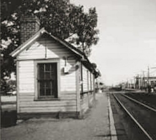
.jpg)
%20-%2008-31-57%20(Faxon,%20Jr.-Keller).jpg)
%20-%2008-16-58%20(Faxon,%20Jr.-Keller).jpg)
.jpg)
.jpg)
.jpg)

%20-%201923%20(Osborne-Keller).jpg)
.jpg)

.jpg)

.jpg)
%20-%2002-21-77%20(Erlitz-Keller).jpg)
.jpg)
.jpg)
.jpg)

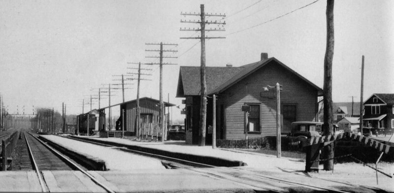
.jpg)
%20-%2012-24-76%20(Madden-Keller).jpg)
.jpg)
.jpg)
.jpg)
%20(Keller-Keller).jpg)
%20-%2007-10-65%20(Smith-Keller).jpg)
.jpg)
-Flatbush_Ave-Bklyn-10-13-78_(Madden-Keller).jpg)
.jpg)
.jpg)
.JPG)
.JPG)
.jpg)
.jpg)
.jpg)
.jpg)
_1.jpg)
_2.jpg)
_3.jpg)
_4.jpg)
_5.jpg)
_6.jpg)
_7.jpg)
_8.jpg)
_9.jpg)
_10.jpg)
_11.jpg)
.jpg)
.jpg)
%20-%20c.%201920%20(Keller).jpg)
%20-%2011-01-70%20(Keller).jpg)
.jpg)
.jpg)
.jpg)
.jpg)
.jpg)
.jpg)
.jpg)
.jpg)
.jpg)
.jpg)
.jpg)
%20-%2002-21-77%20(Erlitz-Keller).jpg)