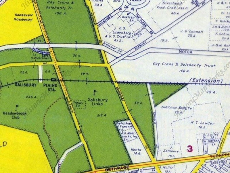
Salisbury Plains - Levittown
LIRR Central Branch Extension
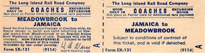
Ticket Meadow Brook-Jamaica Form SX-131
Archive: Brad Phillips
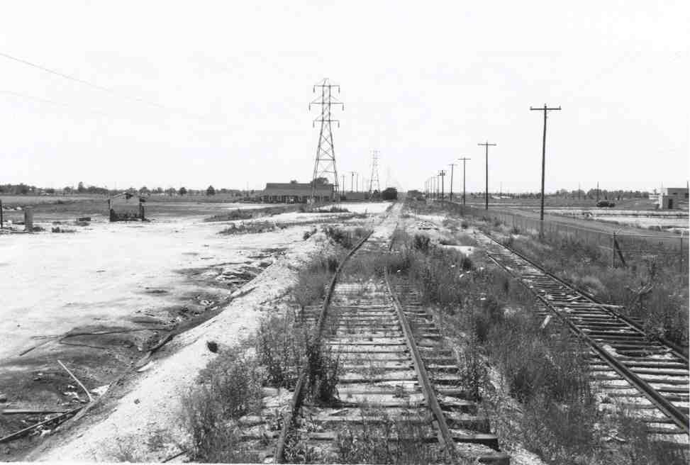
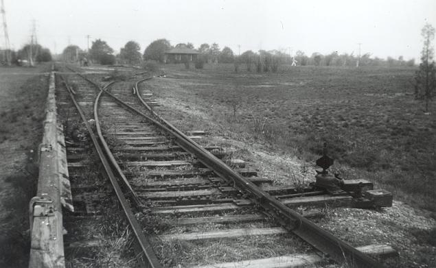
View east from west of Carman Ave, behind Meadowbrook Hospital. Construction materials for the
building of Levittown were delivered here at this siding known from 1948 C.R.4 as "C 24 Newbridge".
Photo: Vincent F. Seyfried 1952
SALISBURY PLAINS: WOODEN SHELTER SHED BUILT: c.
1916 USED TO STORE LUMBER DURING CONSTRUCTION OF 2ND DEPOT. RAZED: 1923 (?)
2ND DEPOT OPENED: 12/10/23, CLOSED: c. 1942-43 DUE TO WARTIME
SECURITY OF TRAINS PASSING THROUGH MITCHEL FIELD TO GET TO THIS STATION STOP. DEPOT BECAME A RESIDENCE AFTER WWII (1947) AND LATER HOUSED A PRIVATE
BUSINESS. TRACKS REMOVED: 1956. RAZED: c. 1990s

Central Railroad of Long Island Extension 1873 Archive: Steve Lynch
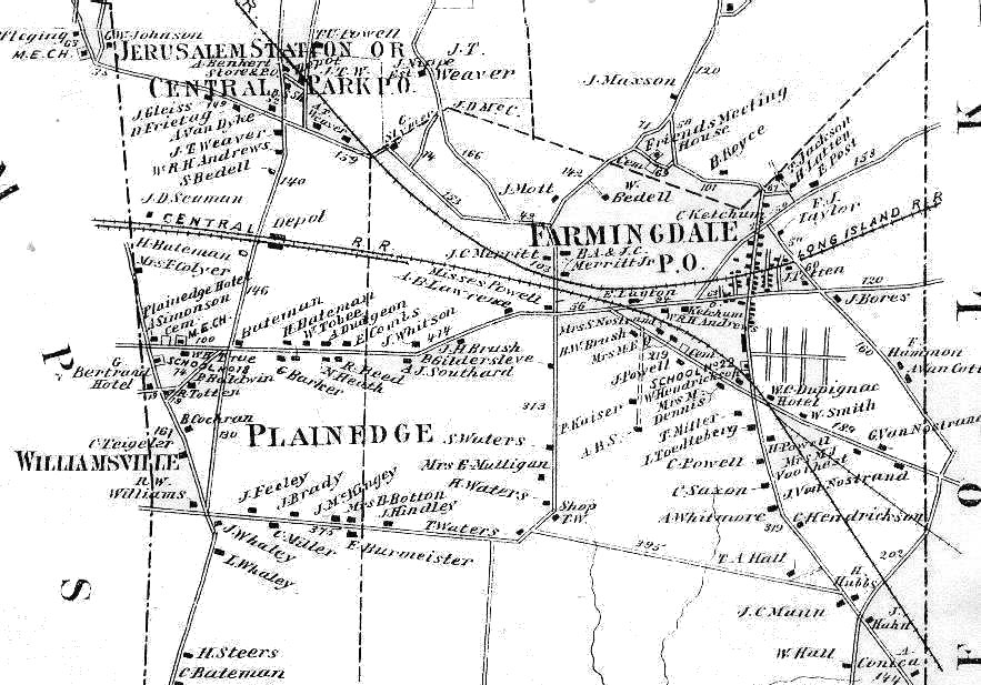
North Nassau Closeup - Central Railroad of Long Island Extension 1873 - Farmingdale Area Archive: Steve Lynch

LIRR Central Branch abandoned 1940's. Info: Roger Ramsdale
Henry Wilhelm visited the area in 1942, 1948, and later. In 1945 the track ended behind Meadowbrook Hospital. In 1948, he noted the sidings for the Levittown constructions materials.
Archive: Steve Lynch
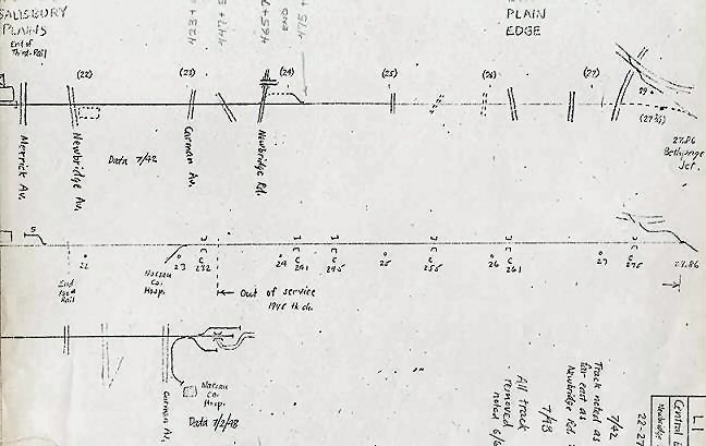
C.R.4 October 1, 1948 Station "C 24 Newbridge" apparently siding installed for delivery of construction materials for Levittown
Archive: Art Huneke
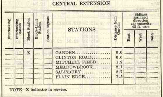
Employee Timetable (ETT) No.2, June 21, 1942 showing track still ran 7.5 miles to Plain Edge and Pass Service to Salisbury (Plains) Archive: Art Huneke
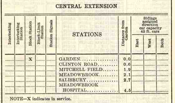
Employee Timetable No.3, September 20, 1942.
Branch cut back to Meadowbrook Hospital, Service cut back to Mitchell Field Archive: Art Huneke

In 1951 there were occasional deliveries for Levittown.
Huneke
View looking west toward Salisbury Plains Station in left background. Photo: Vincent F. Seyfried 1952

View looking east toward Levittown Water Tower in distance from east of Carman Ave. Photo: Vincent F. Seyfried 1952
%20-%2004-01-79%20(Madden-Keller).jpg)
This front view is looking NE on April 1, 1979. The station was on the north side of the tracks and where the photographer stood to take the photo would have been about where the tracks once were. The platform was at the base of the doors and bay window brickwork, with the parking lot in this image at a lower elevation than when tracks ran here. (William Madden photo / Dave Keller archive)
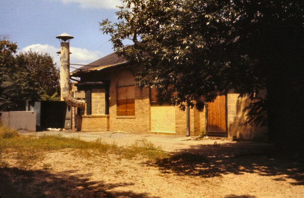
The original grade AND concrete platform were still in place
8/09/64 in this view looking NW. Right after WWII, a young couple lived in the building. When photographed, it appears that some commercial enterprise had occupied it and really messed up the looks of the building. (Richard Makse photo / Dave Keller archive)
.jpg)
This photo shows the building under construction back in 1923. An Ocean Electric trolley is operating the eastbound shuttle from Garden City. Both trolley poles are down as the car was equipped to run using third rail current. You can see the depot was quite picturesque with the arches, through which were the stairs leading down to whatever parking facilities there were at the time. In the later images, those arches were cement-blocked up as was the bay window. At the far right is the original depot, a wooden shelter-shed that appears to have been used during the construction period to house building supplies and keep them out of the weather. (Votava-Keller)
.jpg)
An ex-Ocean Electric trolley bound for Salisbury Plains runs past new base housing at Mitchel Field c. 1928 (Dave Keller archive)
%20-%20c.%201940%20(Huneke).jpg)
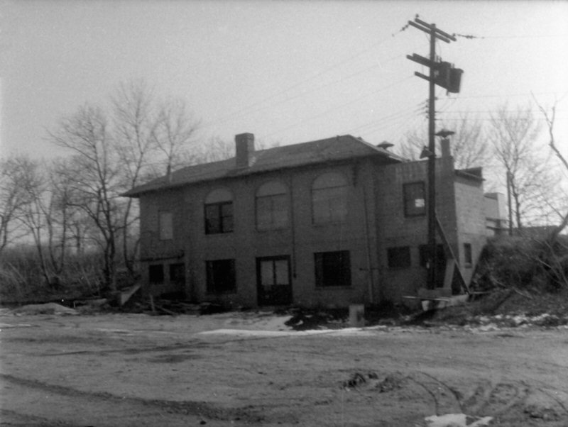
Salisbury Plains Station c. 1940 View NW. Note the station sign still in place at the right. (Art Huneke archive)
.jpg)
After WWII, the depot served as a private residence for a time. This view is 1947.
%20-%2007-27-53%20(Slade%20-%20Huneke).jpg)
The door has been bricked shut and a small section of Spanish roof
tiles are still in place. The resident couple who were there in 1947
appear to have moved out by the time William Slade took this photo on
7/27/53. (Art
Huneke archive)
%20-%2007-27-53%20%20(Slade-Huneke).jpg)
View looking west on 7/27/53 with overgrown tracks still in place, platform lamps still standing and an abundance of nature everywhere! (Wm. Slade photo / Art Huneke archive)
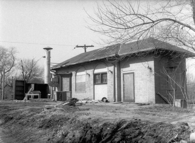
Salisbury Plains Station View NW 12/1962
Photo: Richard Makse

Salisbury Plains Station View W 12/1962
Photo: Richard Makse
Salisbury Plains Station rear view SE 12/1962
Photo: Richard Makse
%20-%2004-01-79%20(Madden-Keller).jpg)
The rear of the station building as it looked on April 1, 1979. The tracks and station platform were in line with the base of the added cement blocks shown on the addition to the building at the far right. You can see where nature has taken over with quite a number of trees that weren't there in 1962! (William Madden photo / Dave Keller archive)
Salisbury Plains Station - View W 8/1967 (Sturm-Fehn)
 While
in college for two summers 1966-67, I worked as a student engineer, across
the street from LIRR #35 at General Applied Science Labs (GASL), a
subsidiary
While
in college for two summers 1966-67, I worked as a student engineer, across
the street from LIRR #35 at General Applied Science Labs (GASL), a
subsidiary
of Marquardt, performing ramjet research and testing, in the building that
had earlier been the Meadowbrook Country Club. A part of the property had
been the old Meadowbrook Station, later the Salisbury Station building.
The station platform was a great place to eat lunch and I spent some of my lunch hours on nice days sitting there. I spent one lunch hour trying to trace the LIRR central branch across the street thru Salisbury Park, but there were few clues left except towards the far eastern side of the park, where a small fill was still evident.
To the west of the station was the "bridge over nothing," which is shown today on a number of websites. It provided access under the LIRR within the country club property. The space under the bridge has long ago been filled in with dirt after the country club closed, but the bridge was still visible. Map: 1946 Hagstrom Nassau Map - Archive: Historic Map Works
By the time I worked
there, the tracks had been lifted, but GASL assumed use of the station
building and surrounding property as part of their facility. At the time
GASL used the platform area, and possibly the interior of the station
building, to store cylinders of compressed gas, probably for use in small
wind-tunnel tests. I remember the cylinders chained to eyes in the wall to
prevent them falling over. Today, it's all gone; GASL, the station,
and the branch extension to Meadowbrook/Salisbury. Info: Art
Single
I'm curious as to whether there ever was a ticket
agency here, otherwise why bother to build a bay window? Perhaps there
were intentions of an agency and it never happened, or . . . it may have had
an agency for a short period of time. . . . Nobody around to know this
anymore. But it was originally just a wooden shelter-shed so somehow someone
felt there was a need to build such a substantial structure for a
"nowhere" station stop at the time . . . A full lower level plus a
full upper level! If the upper level were a waiting room and possibly
a ticket office, I wonder what the lower level housed?
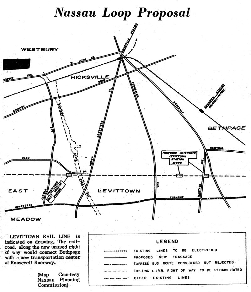
Nassau Loop Proposal - Nassau Planning Commission
Levittown Tribune 6/27/1963

Ex-LIRR ROW Jerusalem Ave. to Hicksville Rd., Levittown
Research: Steve Lynch from Bing Maps
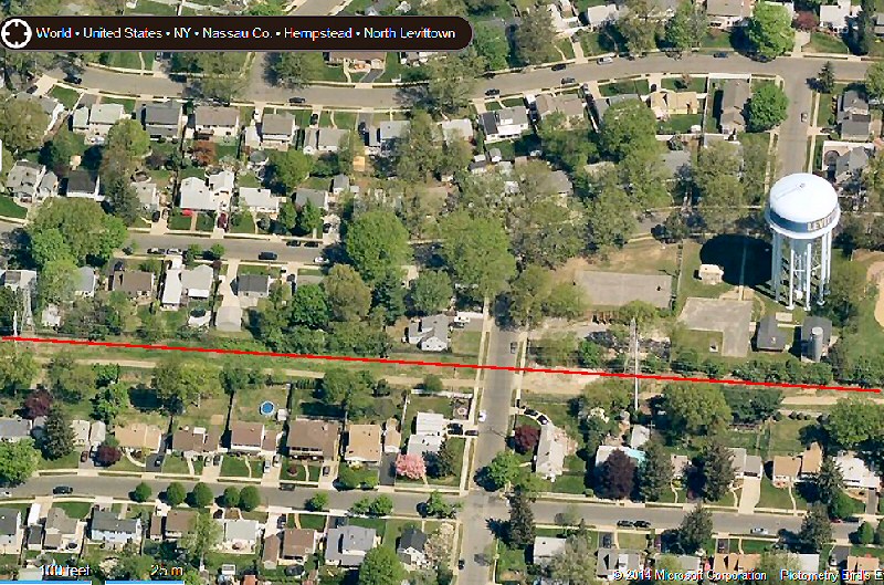
Ex-LIRR ROW at Hilltop Rd., Levittown
Research: Steve Lynch from Bing Maps
The property in Levittown where the main electric utility service wires are, is still owned by the Long Island Rail Road/MTA. This was the site of the former Central Rail Road Line, which is located north of Hempstead Turnpike, Levittown, New York. In the years before Levittown when this was all farmland the local farmers would sometimes refer to it as the "Manure Line". This property has been in the news in the past. In 1963, the Nassau Planning Commission recommended that the rail line should be reactivated as part of a transportation loop. The plan was protested by homeowners along the right-of-way area. This map is from the front page of the Levittown Tribune, June 27, 1963 Info/Archive: Joshua Soren
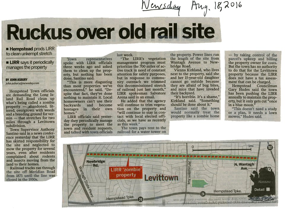
"Ruckus over old rail site" 8/18/2016 (NEWSDAY- Dave Morrison)