|
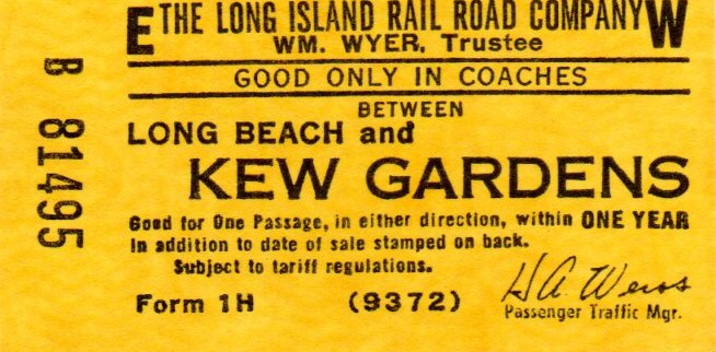
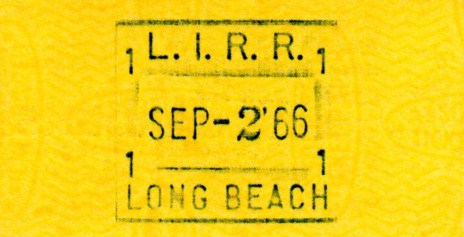
Long Beach
Branch Captions,
Data, Maps and Photos by Dave Keller unless otherwise noted |
|||||||||||||
|
|
|
||||||||||||
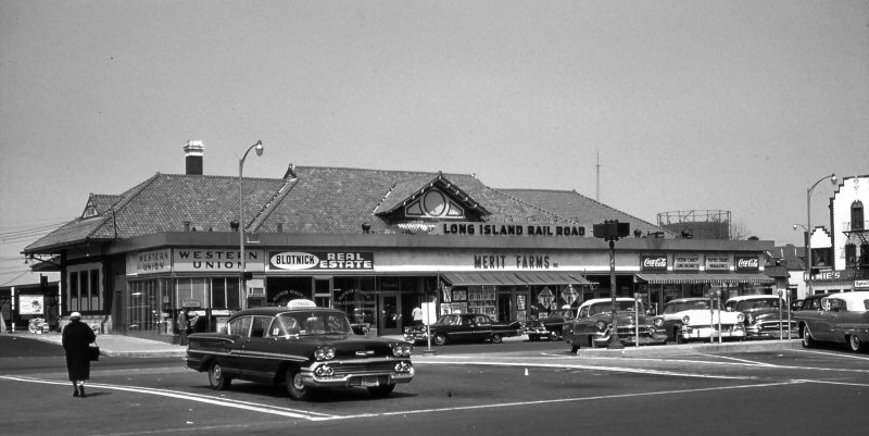
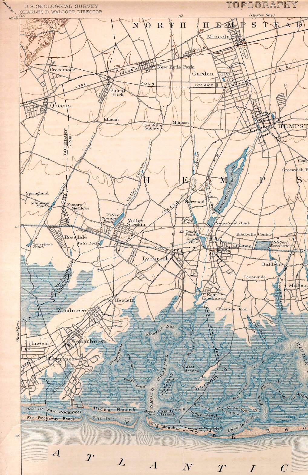
| LYNBROOK | |||||||||||||
|
SOUTH SIDE R. R. SVC. BEGAN: 10/28/1867 AS “PEARSALL’S CORNER.” DEPOT OPENED? LATER BECAME "PEARSALLS." 2ND DEPOT BUILT: 1881. RENAMED "LYNBROOK": 1894. REMODELED: c. 1920. RAZED: 1938 WITH GRADE ELIMINATION. ELEVATED STRUCTURE, 1,113’ WEST OF FORMER LOCATION, IN SVC: 10/18/1938 - Research: Dave Keller |
|||||||||||||
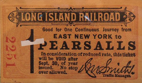 Ticket - East New York to Pearsalls - 1884 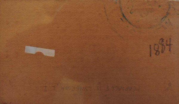 |
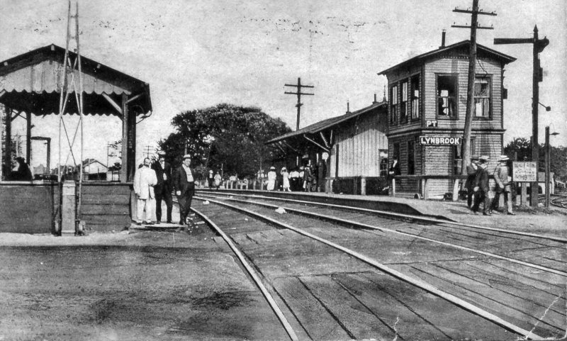
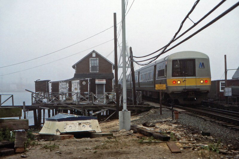
%20-%20c.%201905%20(eBay).jpg) Lynbrook Station Tower #21 -Long Beach Branch side of depot - view NW c.1905
|
||||||||||||
 LIRR Freight receipt: Pearsalls Station - Agent E. P. Frost - Consigned to J. H. L'Hommedieu for 1 case hardware and 2 bundles sash cord 5/16/1882 |
 LIRR Freight receipt: Pearsalls Station - Agent E. P. Frost - Consigned to Long Beach Improvement Co. for 27 lengths of iron pipe and 8 boxes white gloss. 5/16/1882 |
||||||||||||
|
|
%20(E.P.%20Frost%20Agent)%20-%2005-17-1882%20(Keller).jpg) LIRR Freight Receipt - Pearsalls Station (Lynbrook) (E. P. Frost Agent) - 5/17/1882 |
||||||||||||
|
Note: The LIRR
Express receipt does NOT indicate a station, but the agent, E. P. Frost, is
the same agent on the freight receipt that is identified as Pearsalls.
Info/Archive: Dave Keller |
|||||||||||||
 Emery Map PC east of Lynbrook to Merrick Rd. prior to Grade Elimination Project Pre-1938 - Archive: Dave Keller |
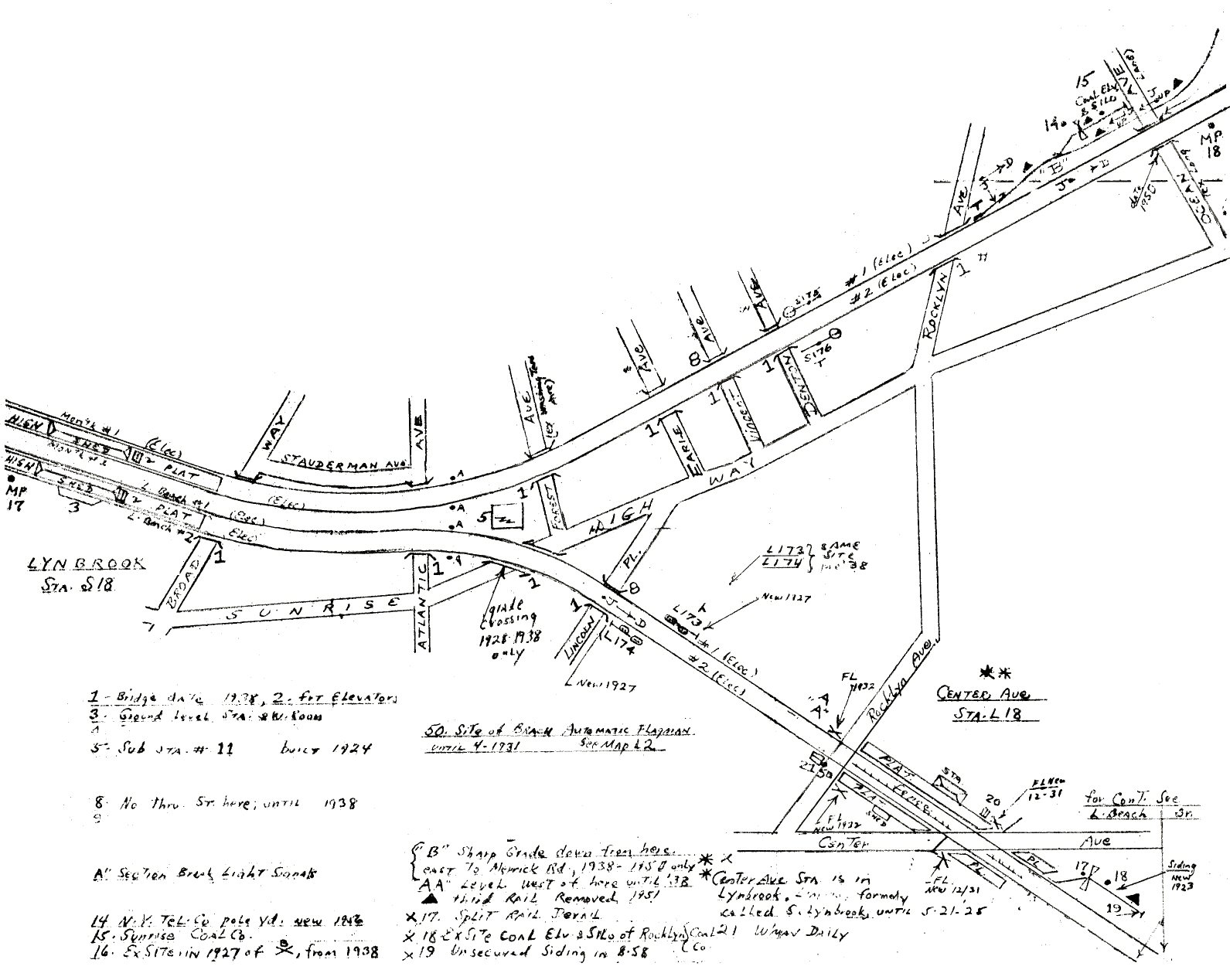 Emery Map Lynbrook 1958 MP 17-18 - Archive: Dave Keller |
||||||||||||
|
1. The 1938 grade
elimination bridged all the crossings up to and including Rocklyn Ave. |
|||||||||||||
 Lynbrook Station - PT Tower - Express Platform view SE c.1907 |
 Lynbrook Station - view NW c.1907 |
||||||||||||
 Lynbrook Station - PT Tower 1908 |
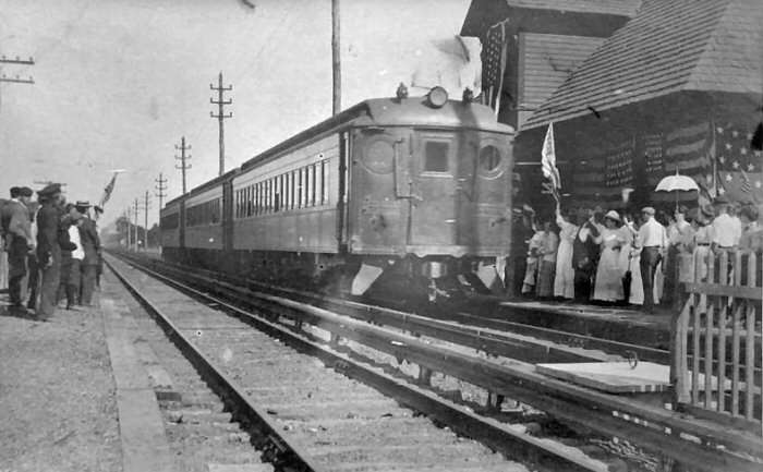
.JPG) Lynbrook Station - 1st train from Penn Station 9/08/1910 Archive: Art Huneke |
||||||||||||
 Lynbrook Station - PT Tower - Express House c.1910 |
.jpg) MU train at Lynbrook Station view E 11/03/53 (Faxon-Keller) |
||||||||||||
|
Note: Perhaps running light eastbound to be rescue motive power east of Babylon, where electrification ends. Or a rescue unit for a stalled freight along the Babylon branch. Basically, though, the H6 and the H10 were primarily freight locomotives, although both had seen passenger service. |
|
||||||||||||
|
|
|
||||||||||||
|
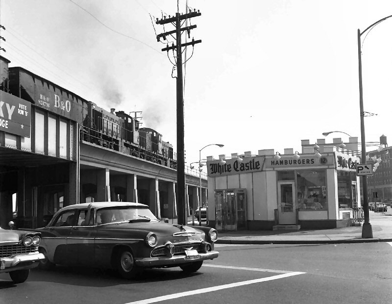
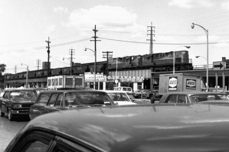
Two ALCO RS1 units, lashed, are pulling a freight train eastbound through Lynbrook, NY on September 28, 1963. Now we'll fast forward to 1967, the last year my father worked before his retirement. He was a stationary engineer and had worked the night shift at Piel Bros. brewery in Brooklyn since 1950. I was 15 at the time of his retirement and on several occasions, he'd take me into work with him and in the morning, when his shift was over, we'd pick a LIRR branch and he'd drive me along the branch, using a 1966 employee timetable as reference and stopping at every station and tower we'd find, for me to get photos for my archive. When we photographed the branches along the south shore (Far Rockaway, Long Beach, Montauk-Babylon, West Hempstead) we'd stop at the White Castle restaurant in Lynbrook, as they actually served a limited breakfast. We'd both have coffee and an English muffin. Coffee was a nickel and the English muffin was a dime. You can see in this image that burgers around that time were only twelve cents. McDonald's burgers were 15 cents but were a bit larger than White Castle's and weren't full of holes! Not only are the ALCO units long-gone, but so is the old Desoto automobile in the foreground, waiting on Broadway for the light at Sunrise Highway to change. (Harold Smith photo, Dave Keller archive) |
|||||||||||||
|
APPEARS ON TIMETABLE OF 4/1898 (CENTER AVENUE) AS
"SOUTH LYNBROOK," IN USE AS A (EAST ROCKAWAY) FLAG STOP. ROUGH
PLATFORM ONLY ON NORTH SIDE OF CENTRE AVE. CROSSING. BECAME REGULAR
STATION STOP AFTER OCTOBER, 1911. LOW-LEVEL PLATFORMS CONSTRUCTED ON
BOTH SIDES OF THE CROSSING. NAME CHANGED TO "CENTRE AVE.": 1925. WOODEN BUILDING WITH SHELTER SHED BUILT BY JUNE, 1925 (Robert Emery Map Provenance), PROBABLY EARLIER. AGENCY OPENED: __?. PART-TIME AGENCY AS OF 01/01/55. AGENCY CLOSED PER “L.I.R.R. TICKET OFFICES OPEN FOR SALE OF TICKETS” EFF: 09/12/55.
MONDAY-ONLY AGENCY REOPENED PER “L.I.R.R. TICKET
OFFICE HOURS” OF 09/18/67. WOODEN DEPOT RAZED AND PLATFORMS NORTH OF
THE CROSSING |
|||||||||||||
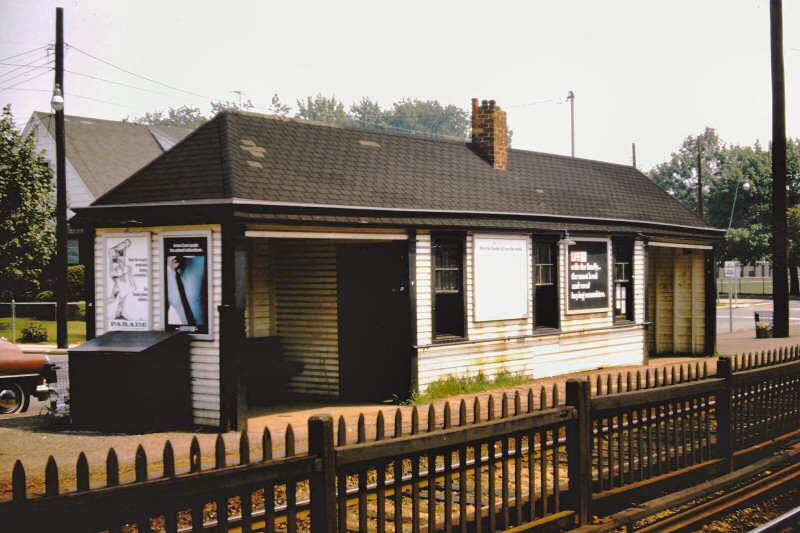
 .jpg) Centre Ave. Station, Lynbrook rough platform only - view NE early 1920's Archive: Art Huneke |
|
||||||||||||
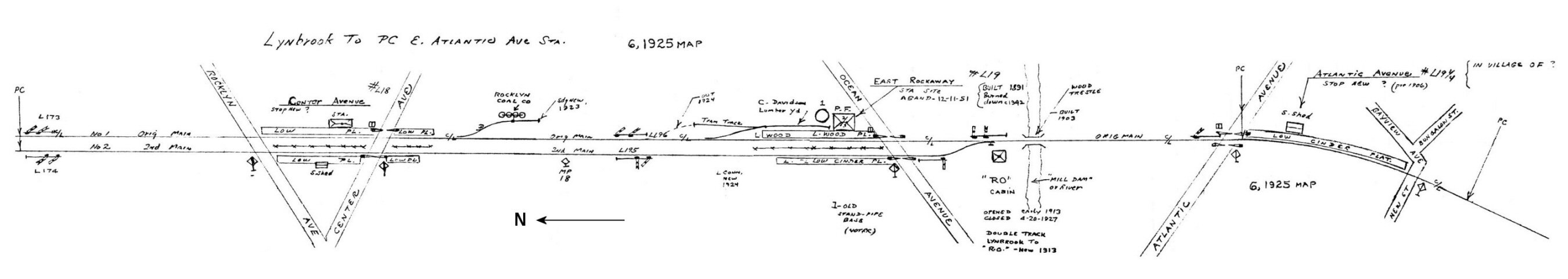 Emery map Lynbrook Centre Ave. Station to east of Atlantic Ave. Station - 6/1925 Archive: Dave Keller |
|||||||||||||
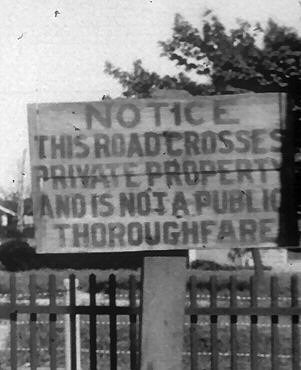 Lynbrook - Centre Ave. crossing sign "Notice this road crosses private property and is not a public thoroughfare" road sign |
%20-%20c.%201920s%20(Huneke).jpg) Centre Ave. crossing, Lynbrook - View E c.1920s Archive: Art Huneke |
||||||||||||
 Centre Avenue 1949 - Photo: Fred Weber Archive: Dave Morrison |
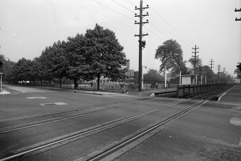
 Centre Ave. Station, Lynbrook View SE 1966 (Sturm-Fehn) |
||||||||||||
%20-%2012-09-82%20%20(Huneke).jpg) Centre Ave. Station, Lynbrook - former low platform - View N from Hi-level Platform 12/09/1982 Archive: Art Huneke |
 Centre-Ave., Lynbrook - View N former low platform gone - 8/14/2025 Photo/Archive: Dave Morrison |
||||||||||||
 Centre Ave. Station high platforms, Lynbrook - Westbound from Long Beach View S 8/14/2025 - Photo/Archive: Dave Morrison |
 Ticket Form LH-261 between Center Ave. and Lynbrook 4/23/1962 Archive: Brad Phillips |
||||||||||||
| EAST ROCKAWAY | |||||||||||||
|
OPENED:
OCT/1880, BURNED: c. 1942, STATION STOP DISCONTINUED: 12/11/51 WITH
RELOCATION OF NEW, COMBINED STOP. |
|||||||||||||
  First MU train from Penn Station at East Rockaway 9/08/1910 |
 East Rockaway - View S across Mill Dam Creek c.1920 Archive: Ed Gloeggler WS is a Whistle and Permanent Speed Restriction post. Note: See Emery map below - East Rockaway to Oceanside MP18-19 9/1958 |
||||||||||||
|
This is East Rockaway (above right)
after the 1910 electrification and before the 1927 double tracking.
The photographer is standing on Ocean Avenue Crossing which is at the west
end of the present station, and the view looks south -- railroad east. Until
1927 double track ended just west of this photo. The track runs
through Mill River, which crosses today's station under a narrow bridge.
The land was all filled in the late 1930s. |
|||||||||||||
 East Rockaway Station 1966 (Sturm-Fehn) |
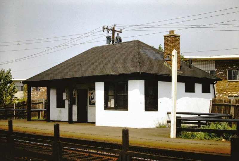
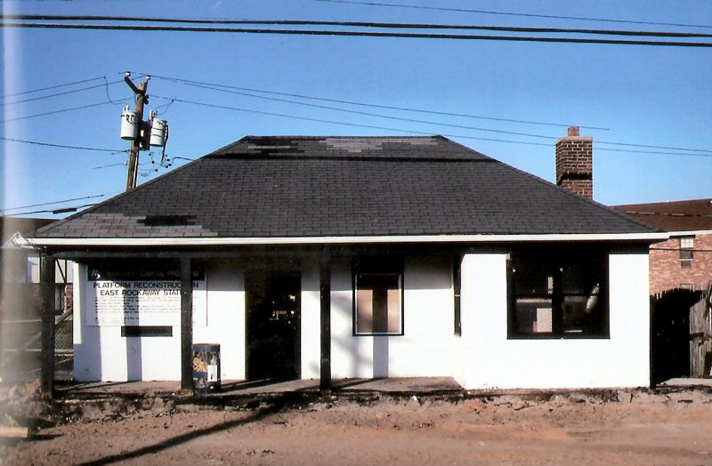 East Rockaway Station - Platform Reconstruction View E c.1995. The LIRR had a program to replace any of the remaining asphalt on wood high level platforms that date from that late 60s/early 70s era. The “meatball” M further dates this sign to the first half of the 1990s. Info: Mike McEnaney |
||||||||||||
|
East Rockaway Station: Not so long ago, a member of the Davison family reached out to the Historical Society of East Rockaway & Lynbrook to share with us a memoir written by her Grandfather, Oliver S. Davison II. It was the first time I had read this particular account of East Rockaway’s history, needless to say, it has been a huge asset to our collection, and we look forward to sharing more of these stories with you! In the document, Mr. Davison shares a story his father, Russell S. Davison, had told him about the railroad coming through East Rockaway in the early 1880s. In those days, his great-grandfather, Oliver, and his great-granduncle, Charles, had owned the old mill, and most of the land south of modern-day Ryder Place. When the New York & Long Beach Rail Road was planning its route, which ran from Pearsalls to Long Beach, it needed to obtain land, not only for trackage but for passenger stations and freight houses. According to the story, representatives of the Davison family, likely Oliver & Charles, met with the railroad company to work out a deal. The Davison's agreed to gift a one-mile right of way through their property, in return for siding at their lumberyard. Siding is when a loop is built off of the main rail line. In this case, freight trains could stop to load and unload goods and materials, without disrupting passenger service. On November 5th, 1880, a passenger station and freight house were opened for service on the newly laid out Davison Plaza, where it would remain for many years. This is where the story gets
interesting. As a part of the state’s initiative to eliminate grade
crossings along the Long Island Rail Road’s, Montauk and Atlantic branches,
tracks east of Jamaica were elevated. By 1938, the project reached Lynbrook.
The plans called to elevate the Long Beach line to a point just south of the
present-day Oceanside station and to consolidate both the East Rockaway and
former Atlantic Avenue signal station, which once stood just south of
Atlantic Avenue, into one elevated station situated where the present-day
station now stands |
|||||||||||||
| OCEANSIDE | |||||||||||||
|
|
|||||||||||||
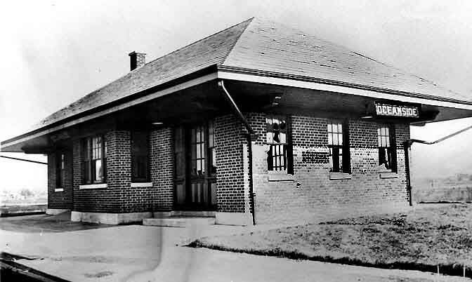 Oceanside Station - LIRR valuation photo 1919 Archive: Art Huneke |
 First Oceanside Station c.1920's eBay image |
||||||||||||
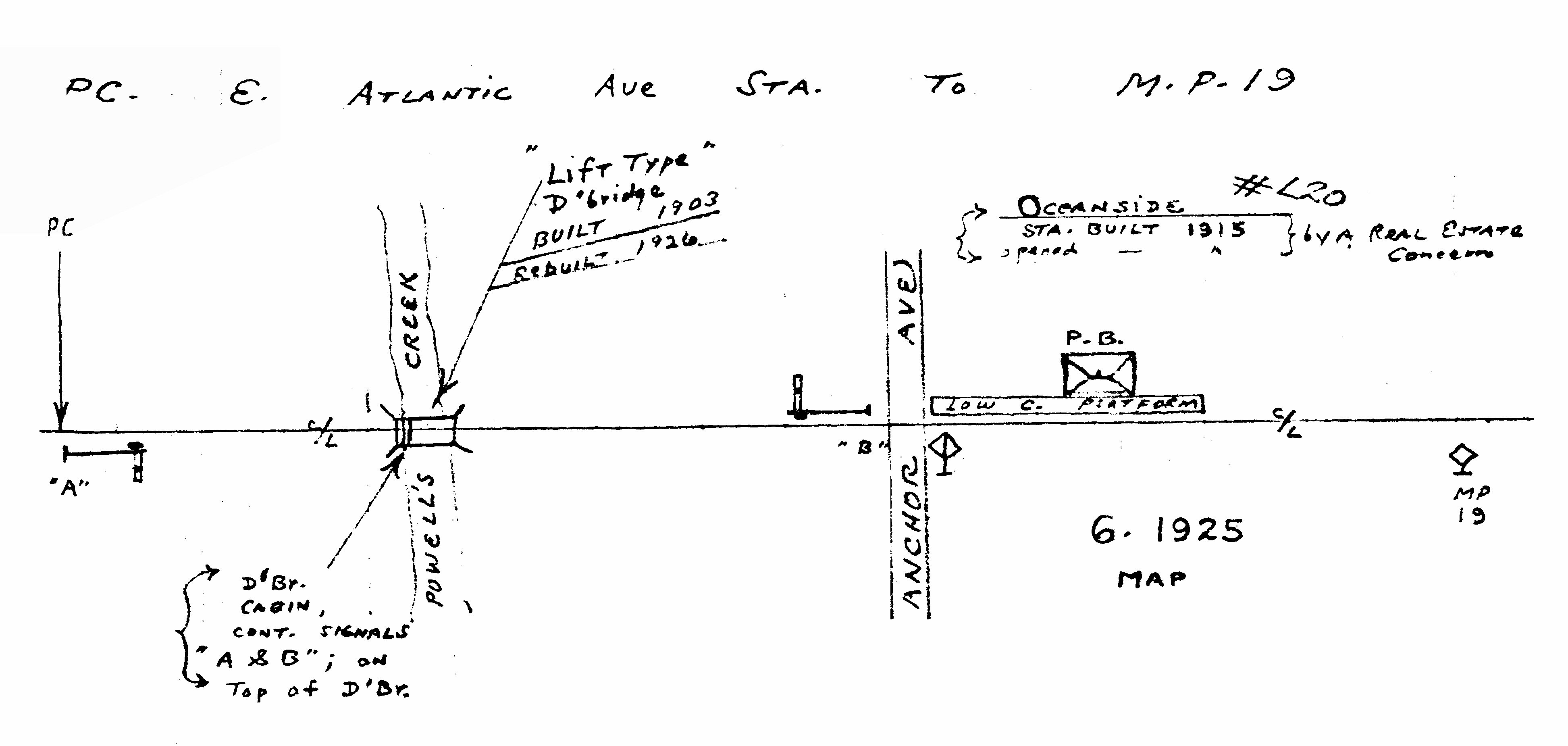 Emery map - East Atlantic Ave Station to Oceanside MP19 1925
|
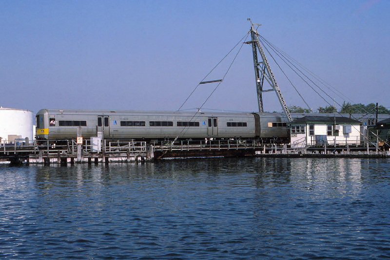
 Powell's Creek Drawbridge - 9/15/1906 Photo: William Rugen - Archive: Queens Borough Library |
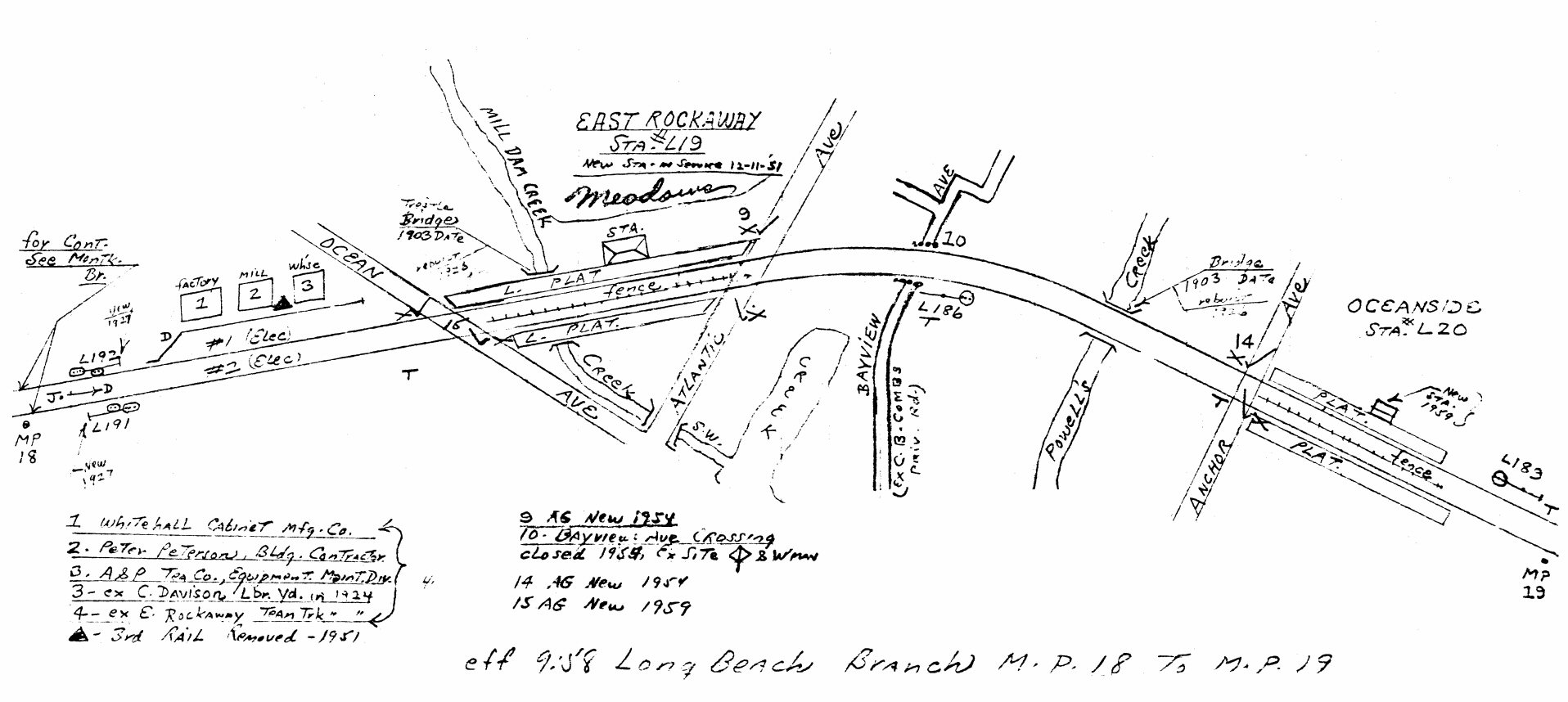 Emery map - East Rockaway to Oceanside MP18-19 9/1958 |
|||||||||||
|
Note: It was a drawbridge, but with no
mechanical equipment to open it. Openings were done with the wreck
crane at very infrequent intervals. It has a pivot mechanism at one
end and eyes for the crane's cables at the other with iron latches to keep
it from floating up in high tides. The MTA, in 2010, said it will be
raised another foot higher so it is not subject to flooding at unusually
high tides. |
|||||||||||||
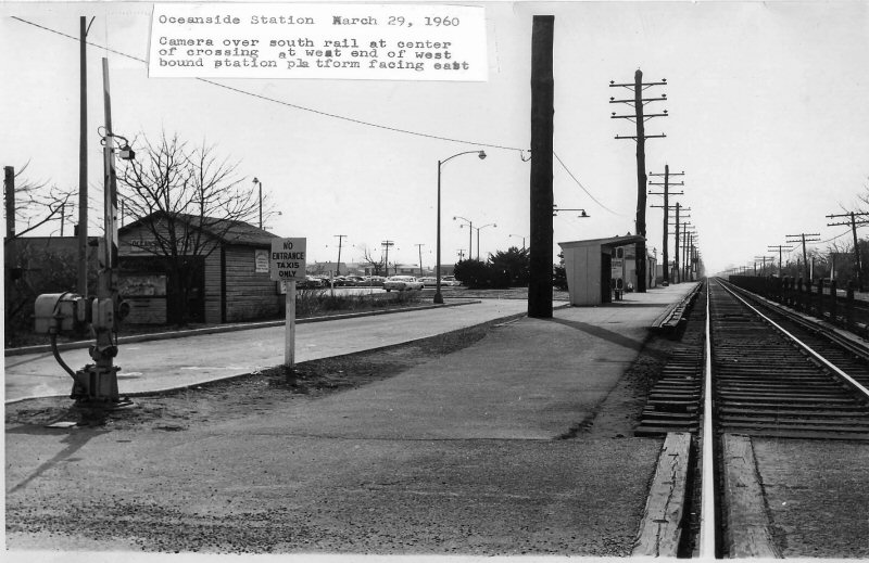 Oceanside Station View N 3/29/1960 (Weber-Morrison) |
 Oceanside Station View S 3/29/1960 (Weber-Morrison) |
||||||||||||
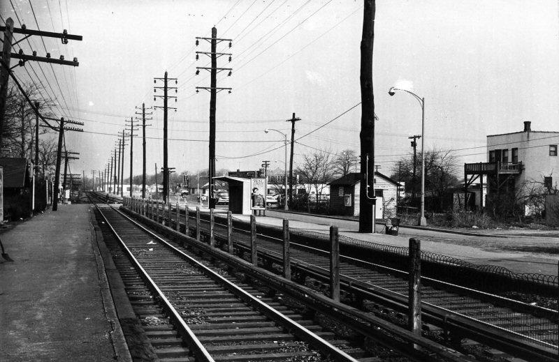
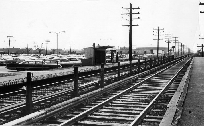 Oceanside Station View SE 3/29/1960 (Weber-Morrison) |
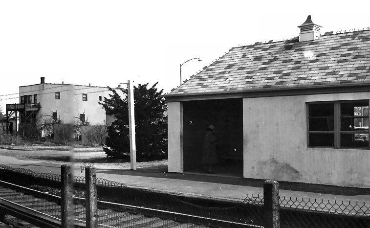 Oceanside Station View SW 3/29/1960 (Weber-Morrison) |
||||||||||||
.jpg) Train at Oceanside 2nd Station 10/21/61 (Faxon-Keller) |
|||||||||||||
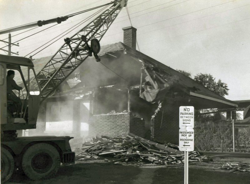
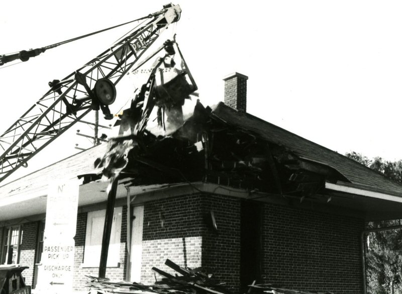
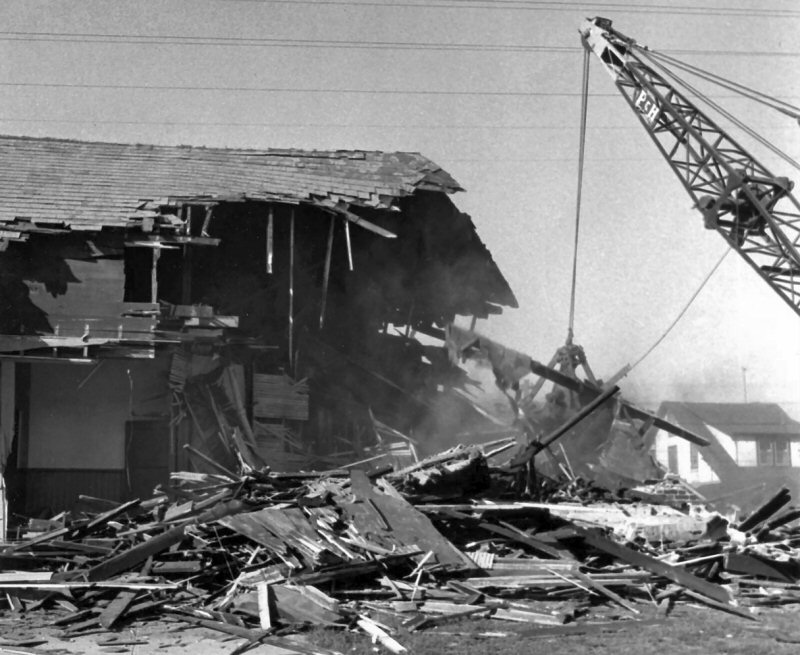
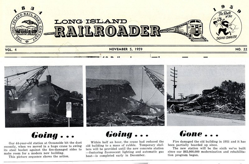 Oceanside Raze - LI Railroader 11/05/1959 Archive: Dave Morrison |
|||||||||||||
|
|
|
|||||||||||
| Oceanside Raze 10/1959 - Photos: Irving Solomon Archive: Dave Morrison | |||||||||||||
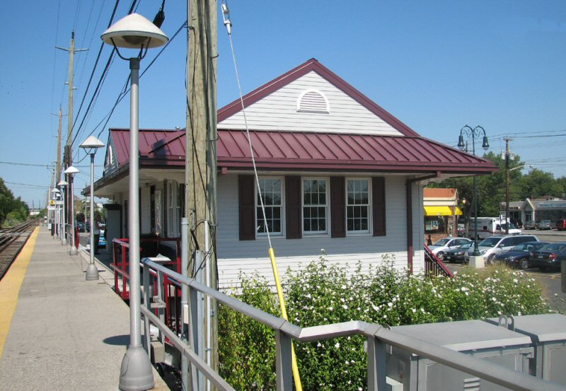 Oceanside 3rd Station c. 2005 |
|||||||||||||
| ISLAND PARK | |||||||||||||
|
|
|||||||||||||
 |
 |
ISLAND PARK AGENCY CLOSED AS OF 06/46, BUT OPEN AGAIN AS OF 09/12/55. AGENCY FINALLY CLOSED: ? | |||||||||||
| Form 1˝H Island Park - Center Ave - 4/23/1962 GPA: Bannard Archive: Brad Phillips | |||||||||||||
|
The Island Park office was closed in 6/1946. The ticket purchased was printed during the GPA: Homer Bannard era 1946-1948 when the office had been open sometime during that period. The station building was constructed prior to 1946, with a ticket office. Chances are, after the agency closed in 1946, the development in the area led to increased ridership (look at post-war Levittown) and the ticket agency may have possibly reopened in 1947 or 1948. I do know the agency was indicated as "open" in the list of station ticket office hours that I have dated to 1955. Note: The pre-printed ticket with two stops: Island Park and Center Avenue, was very odd for those two stations due to their proximately. Blank stock would normally have been used. Chances are, when the LIRR decided to re-open the agency, they tried to use up the already pre-printed ticket stock, rather than destroy all the older stock. Info: Dave Keller |
|||||||||||||
|
|
|||||||||||||
|
The station’s main operating equipment includes two steam electric units (Units 1 and 2) with a combined generating capacity of up to 370 megawatts (MW) that were placed in-service in 1956 and 1963, respectively. The northern portion of the site is
developed with gas turbines (GTs), including eight General Electric Frame units (combined capacity of 120 MW) and four Pratt & Whitney aero-derivative twin-pack gas turbines (combined capacity of 160 MW) that were placed in service in 1970 and 1971, respectively. |
|||||||||||||
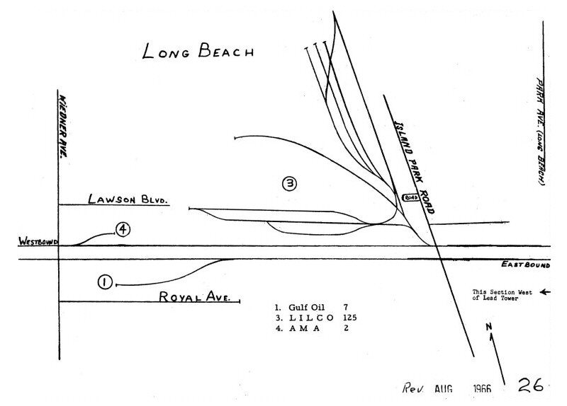
 Barnum's Channel - Island Park - Edward F. Barrett Power Station View S Source: Mapcarta 2018
|
 LILCO Power Plant approaching Barnum's Channel - Island Park View S Google Maps 2018 |
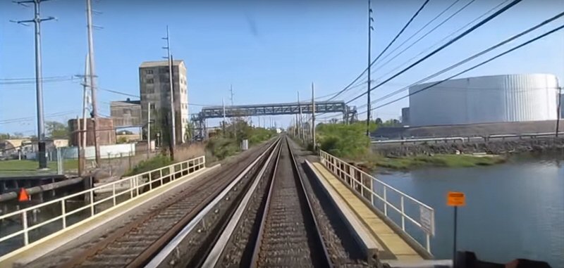 Barnum's Channel - Island Park View S Google Maps 2018 Note: Referred to as Hog Creek/Channel at one time; as per Emery Map 1958 (below left) |
|||||||||||
|
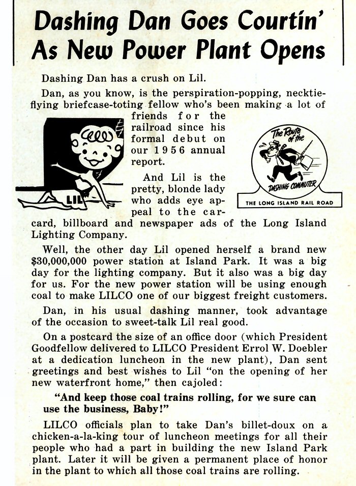
SOUTH SIDE EXTRA: In 1957 the Long Island Lighting Company (LILCO) opened a new coal burning power plant in Island Park. The railroad underbid a barge operator and won the contract to deliver their coal. The coal trains were known as "South Side Extras" |
|||||||||||||
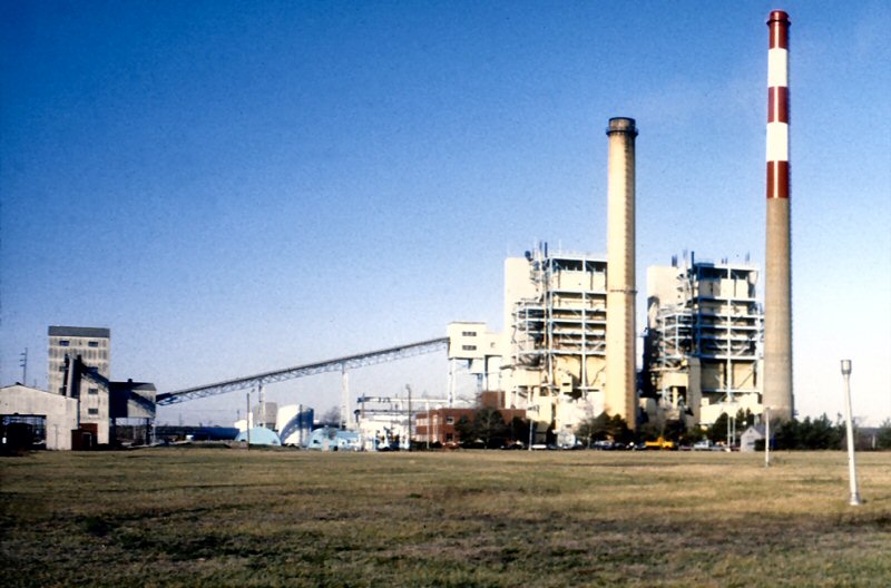 LILCO Island Park Plant c. Photo/Archive: Art Huneke 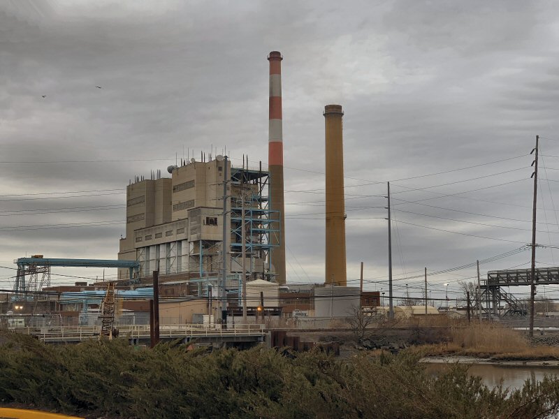 LILCO Island Park Plant view SE 1/11/2023 Photo: Joe Vila |
 LI Railroader 6/20/1957 LILCO Island Park Plant Archive: Art Huneke |
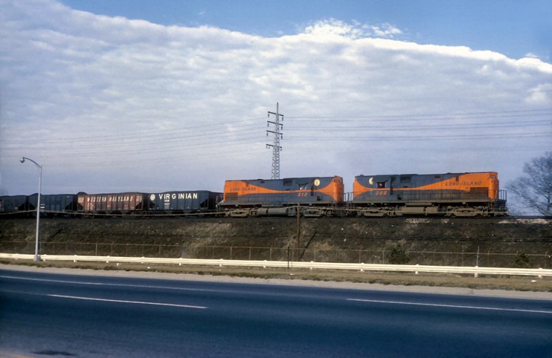 EXTRA 206 East with C420 #212 east of Valley Stream - Photo/Archive: Art Huneke
|
|||||||||||
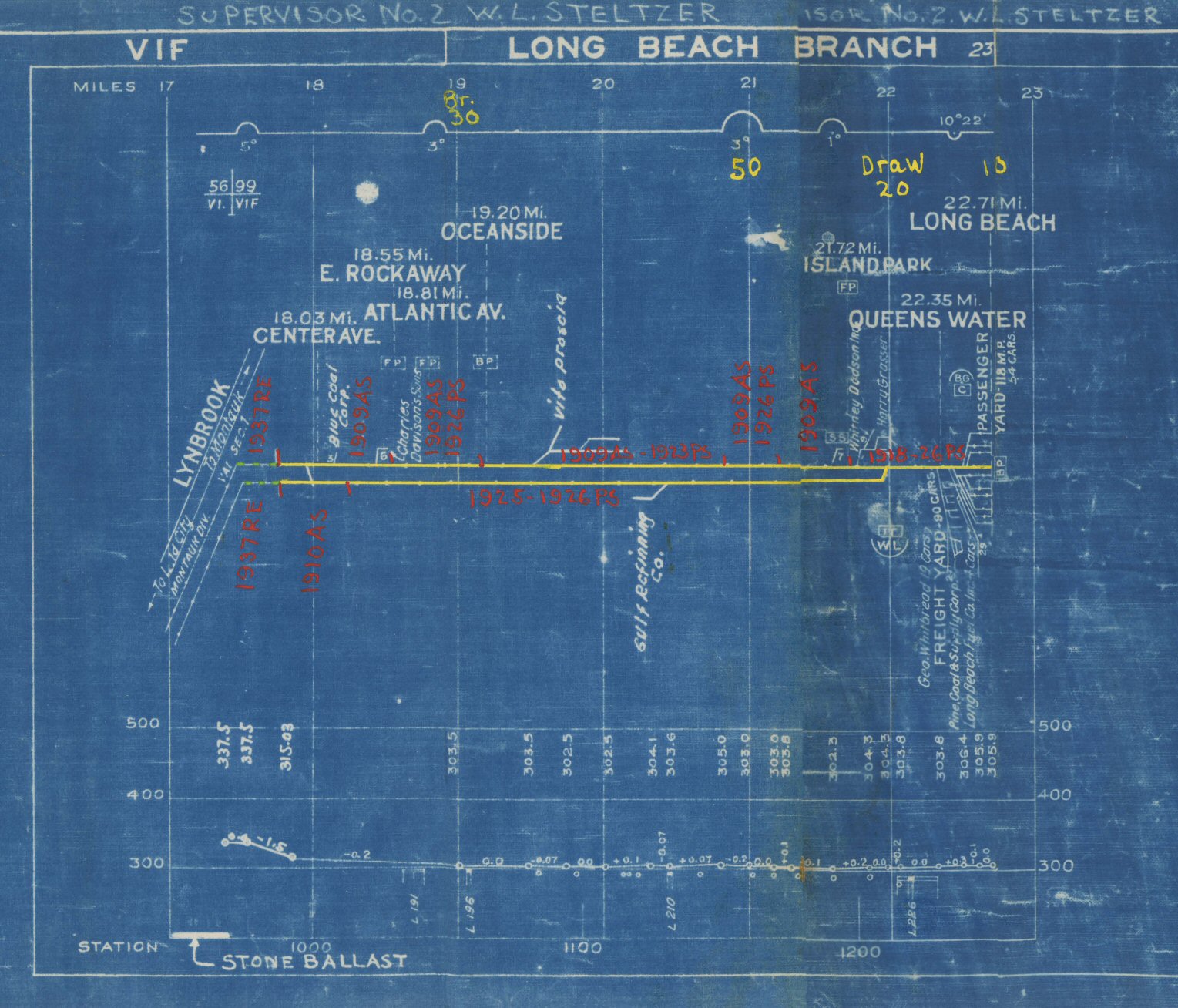
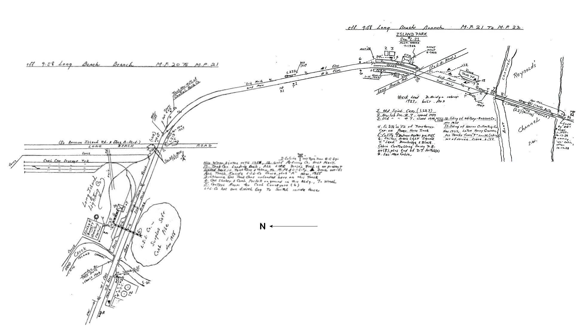
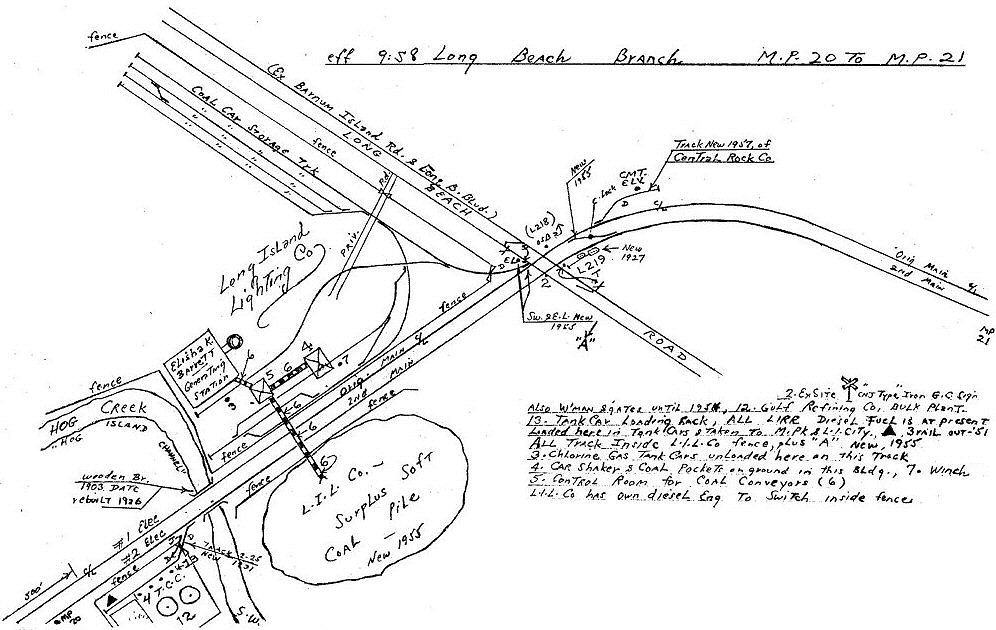 Emery maps MP20-21, MP21-22 9/1958 Archive: Dave Keller 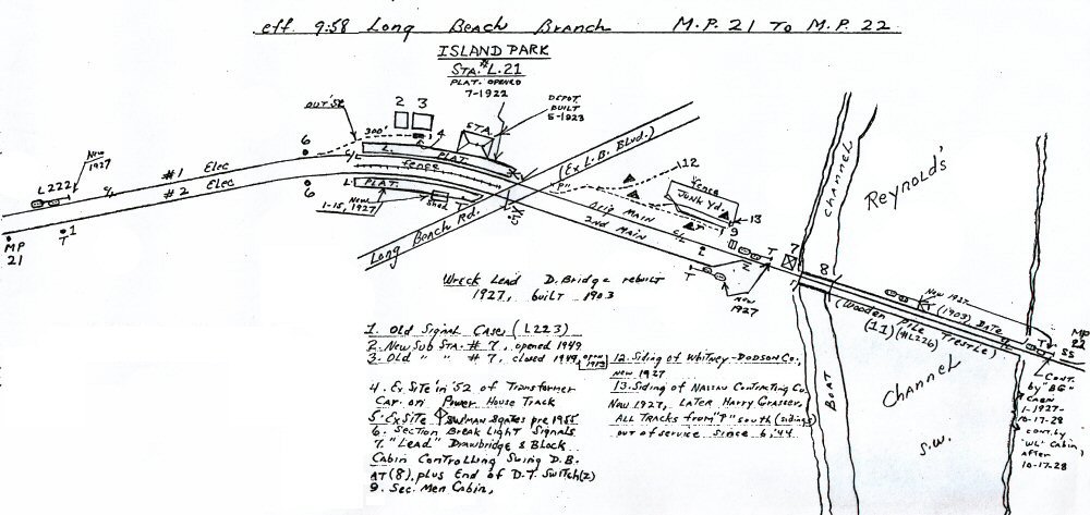 |
 Extra 208 West routed through Zero Track to the westbound Montauk Branch as seen from JAY Tower. Photo/Archive: Art Huneke |
|
|||||||||||
|
Switching the Coal at Island Park by JJ Earl "...the coal
train used the trailing point cross over east of Long Beach Road to shove
across into "The Light" (LILCO plant). Loads would be placed in the
empty tracks and empty cars gathered up and pulled out onto #2 main.
|
"Moving
Coal by Prayer"
|
||||||||||||
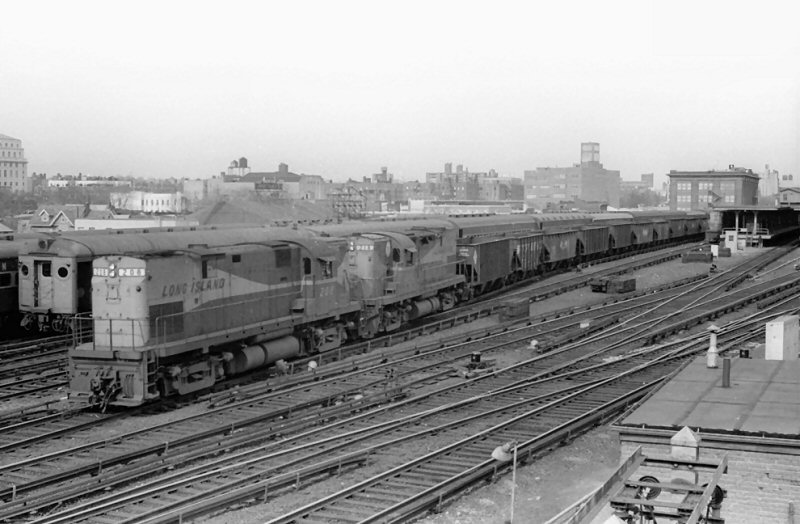
 M1 9500-9499 (Budd, 1971) leads another off-peak six-car train, this time to Long Beach. This is just north of the first Long Beach Road crossing and the Long Island Lighting Company spur, still active in 1975, curves off to the right. The tracks here actually form the border between the Village of Island Park, to the left, and the Hamlet of Barnum Island, to the right. 12/27/1975 Photo/Archive: Jeff Erlitz |
 LEAD Interlocking, switch 01 photographed 12/27/1975. Note, not one but two ASC Cut-Out signs. At this time, there still wasn't ASC on the branch except for the trestle over Reynolds Channel/Wreck Lead. The backs of home signal 02Rb on Track 2 and dwarf signal 02Ra on Track 1 are just past the switch and 02Ra is still an original US&S Style R-2 color-light signal. Photo/Archive: Jeff Erlitz |
||||||||||||
|
|
|||||||||||||
 Island Park elevated signal equipment 4/2019 Source: thelirrtoday.com |
 Island Park new signals 4/2021 Source: thelirrtoday.com |
||||||||||||
|
The new signal system
brings full, bi-directional 261/410 speed control and cab signaling to the
Long Beach Branch between LEAD Interlocking in Island Park and VALLEY
Interlocking in Valley Stream. This will offer additional flexibility and
brings this branch into line with what LIRR has in most other places on
the railroad. Previously, the Long Beach Branch had cab signaling and
speed control only in the 'normal' direction (meaning for westbound trains
on track 1, eastbound trains on track 2). When trains operated in the
'reverse' direction, they did so under "Controlled Manual Block" and
without speed control. |
|||||||||||||
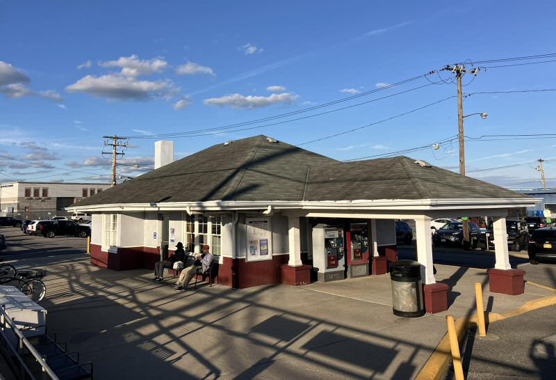
 Island Park Station - Winter view SW 1963 Photo/Archive: Brad Phillips |
 Island Park Station - Summer view E 1966 (Sturm-Fehn) |
||||||||||||
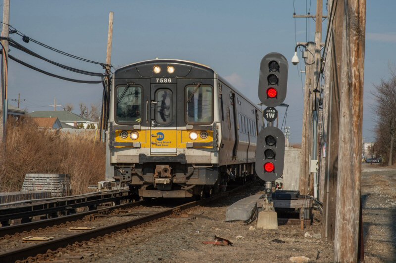 A new signal system was placed into service on the Long Beach Branch on 4/18/2021. This was part of a Sandy recovery project. Until that date, eastbound movements on Track 1 and westbound on Track 2 were still manual block with no Automatic Speed Control. The new signal system remedied that but also converted the position light signals at Lead (pronounced leed, from the water channel the railroad crosses here, Wreck Lead Channel) Interlocking here to color lights. What goes around comes around, though. Until 6/30/1976 the signals at Lead were color light, from the original signal contract in 1927 when the double track was extended from Oceanside to this point, in Island Park. M7 #7586 Train #6852 (Penn Station-Long Beach) onto the single main track east of Island Park station (geographically south) in this view northeast on 2/26/2023 Photo/Archive: Jeff Erlitz Consist: 7586-7585+7686-7685+7152-7151+7328-7327 |
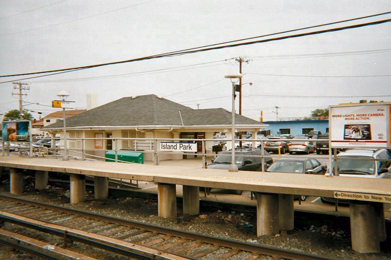 Island Park Station 6/10/2009 View NE
|
||||||||||||
|
REYNOLD'S CHANNEL |
|||||||||||||
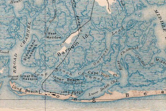
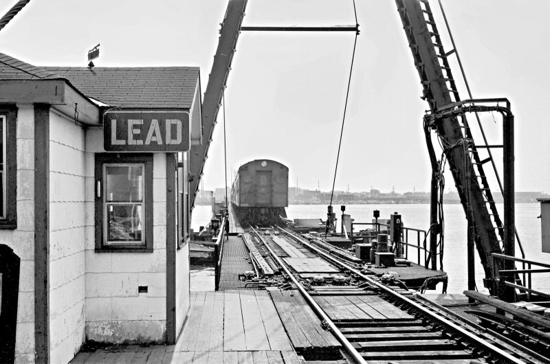
A lead is an old nautical expression for a navigable channel or passage that also found its way into railroading. That portion of Reynold's channel where the bridge is was more complex prior to the dredging operation, with several sand bars and islands in the midst of the channel and the shore of Barnum Island (southern portion of Island Park) farther north than it is today. The wider passage hugged the shore of Barnum Island and that was the original Wreck Lead. Whatever event (shipwreck of some sort, perhaps) that named it occurred before then. Approximately where the bridge cabins
used to be, there were several smaller bars, the largest was called Inner
Island and the smaller channel was called Inner Lead. Please
Note: The following from the 1899 map: |
|||||||||||||
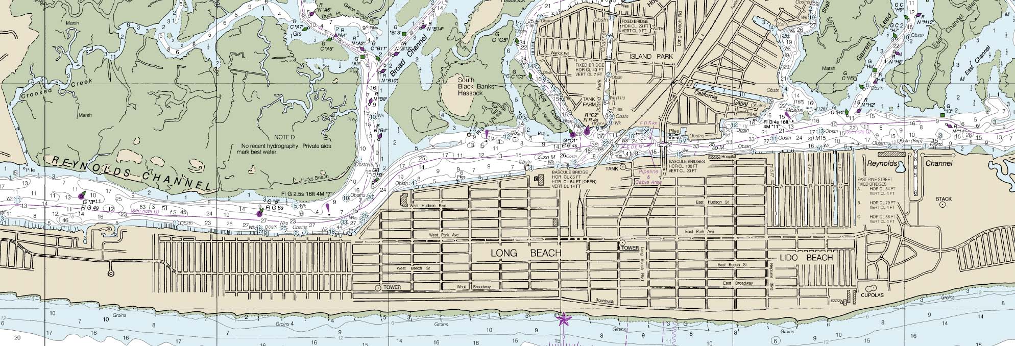 Long Beach - Reynolds Channel - NOAA Nautical Chart view N |
|||||||||||||
| LEAD INTERLOCKING | |||||||||||||
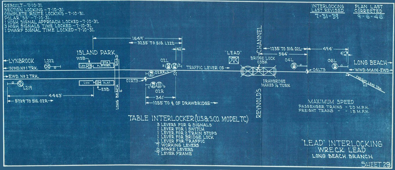 LEAD Interlocking diagram - 9/06/1946 Archive: Jeff Erlitz |
|||||||||||||
| LEAD CABIN | |||||||||||||
|
EAST
SIDE OF SWING BRIDGE AT REYNOLD’S CHANNEL - LONG BEACH (PREVIOUSLY
“WL” [WRECK LEAD] CABIN. |
|||||||||||||
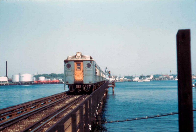
.jpg) Wearing the Tichy color scheme but in real need of a repainting, a 5-car MU electric train is heading across Reynold's Channel. Looking northwest in this c. 1956 view, we see the train consists of TWO combine baggage cars coupled at the same end of the train. Also noticeable is the swing bridge and LEAD cabin in the right background. Whatever the guy is doing, dangling from the open baggage compartment door of the combine, it can't be too smart. (W. J. Edwards photo, Dave Keller archive) |
 MPB-54 heading across Reynold's Channel (Wreck Lead) trestle. View S - 9/23/1956 Photo: Frank Pfuhler Archive: Daniel V. Brown, Jr. |
||||||||||||
.jpg) Sporting the dark grey color scheme with orange-painted end doors, another MU electric train is heading across Reynold's Channel in this c. 1957 view looking northeast. In the left background is the swing bridge. (Edward Hermanns photo, Dave Keller archive) |
.jpg) A 3-car double deck train is heading across Reynold's Channel in this view looking northwest on October 13, 1963. As the headlight is not lit, the train is heading north (railroad west) away from Long Beach terminal. The swing bridge and LEAD cabin is in the right background. The conductor, minus uniform cap, is checking out something that's obviously caught his attention. "Dang! That's one helluva bikini!" (W. J. Edwards photo, Dave Keller archive) |
||||||||||||
.jpg) A 10-car MU electric train is passing over Reynold's Channel c. 1954. The lead car is in the Tichy color scheme. At the far left in this view looking northeast is the swing bridge and LEAD cabin. (Edward Hermanns photo, Dave Keller archive) |
.jpg) Here's a different view of "LEAD" cabin and swing bridge at the boat channel of Reynold's Channel looking out the window at the rear of a moving MU electric train. This 1964 scene is looking north. (Rolf H. Schneider photo, Dave Keller archive) |
||||||||||||
.jpg) Shot the same day from the same train, only now off the trestle over Reynold's Channel and heading towards the Long Beach terminal facilities, the photographer has framed the image through the round "owl's-eye" window at the end of the MU car. (Rolf H. Schneider photo, Dave Keller archive) |
.jpg) Looking southeast in 1967, LEAD cabin stood on the east side of the swing bridge, where it not only controlled the operation of the bridge to allow boats to pass, but also controlled the interlocking for trains into and out of the Long Beach terminal. (Dave Keller photo and archive) |
||||||||||||
.jpg) Passing by the clutter of various forms of construction along the water's edge, an MU electric railfan extra passes near LEAD cabin as it crosses the wooden trestle over Reynold's Channel on November 1, 1970. (Dave Keller archive)
|
|
||||||||||||
.jpg) LEAD Cabin and Swing bridge View N 2/05/1978 (Wm. Madden Photo / Dave Keller archive) |
 LEAD Cabin and Swing bridge (Wreck Lead) View S 6/1986 Photo/Archive: Jay Bendersky
|
||||||||||||
|
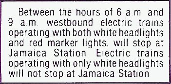
M1 electric MU cars had red markers lit alongside the headlights of the lead car. This was to alert people that it would be making a Jamaica stop and not a Penn Station express. The markers also indicated the train would be short cars from its normal consist. ANY LIRR train coming into Jamaica w/b that normally had, for example, 10 cars, only had 8 cars that day, so commuters seeing the markers on the train arriving (at a distance, say, before HALL Tower), could readjust their platform position and get a better seat or to not delay the train further by having to walk "up" from the east end of the platform. Believe it or not, that came from commuters who complained that the LIRR should let them know when a train was going to be short cars before actually arriving at Jamaica and then their having to run up to board and lose a potentially good seat to boot. (Robert Myers data) |
|||||||||||||
.JPG) LEAD cabin and Swing Bridge Replacement - View N 4/17/1988 (Jeff B. Erlitz photo, Dave Keller archive)
|
.JPG) LEAD cabin and Swing Bridge Replacement - View S 4/17/1988 (Jeff B. Erlitz photo, Dave Keller archive)
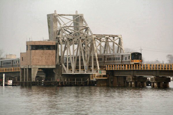
That's the replacement "LEAD" tower and drawbridge. The waterway is "Reynold's Channel," formerly "Wreck Lead" hence the derivation of the name of the old block cabin and this replacement tower. The drawbridge was placed in service on May 2, 1988 and the new tower on May 9, 1988. Research: Dave keller |
||||||||||||
.jpg) LEAD Cabin Model Board 2/05/1978 (Erlitz-Keller) |
.jpg) LEAD Cabin Interlocking Table Machine 2/05/78 (Erlitz-Keller) |
||||||||||||
 LEAD Cabin - Reynold's Channel M3 eastbound 9/1987 |
Although
I worked at Lead occasionally, at the time, I always wanted to try
something different for a photo before the old Lead Bridge was replaced.
In September of 1987, I got the opportunity and took this photo of an M3
eastbound, from my Parent's boat while in Reynolds Channel. View W
Note: LIRR May 25, 1970 ETT SPECIAL INSTRUCTIONS: |
||||||||||||
| LEAD TOWER | |||||||||||||
|
DRAWBRIDGE
– LONG BEACH AT REYNOLD’S CHANNEL
(DRAWBRIDGE LOCATED 400’ EAST OF FORMER LOCATION |
|||||||||||||
| Reynolds Channel Bridge Dedication - 1988 | |||||||||||||
 MTA/LIRR President Bruce McIver Invitation |
 |

LIRR Reynolds Channel Bridge Dedication Press
Release |
|||||||||||
 |

LIRR publication Along The Track March 1988 |
 |
|||||||||||
 Reynolds Channel Bridge Dedication brochure 6/13/1988 - Archive: Dave Morrison |
 Reynolds Channel Drawbridge Dedication Medallion 6/13/1988 - Archive: Dave Morrison |
 Reynolds Channel Bridge Dedication brochure back |
|||||||||||
|
|
|||||||||||||
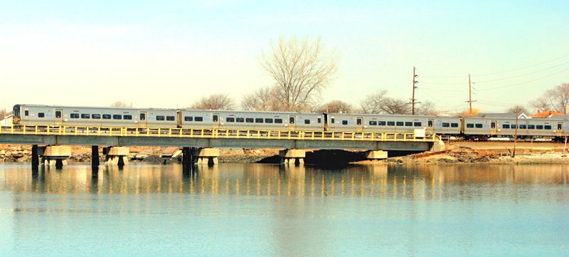
 M1s trundle across the Reynolds Channel/Wreck Lead trestle and into Long Beach. Home signal 04L, with the Begin ASC sign, are between the second and third cars. At this time, the automatic speed control extended basically just across the drawbridge only. 6/17/1977 Photo/Archive: Jeff Erlitz |
|||||||||||||
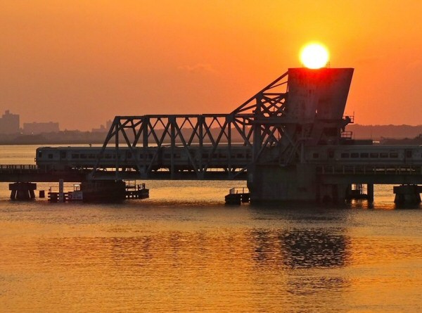
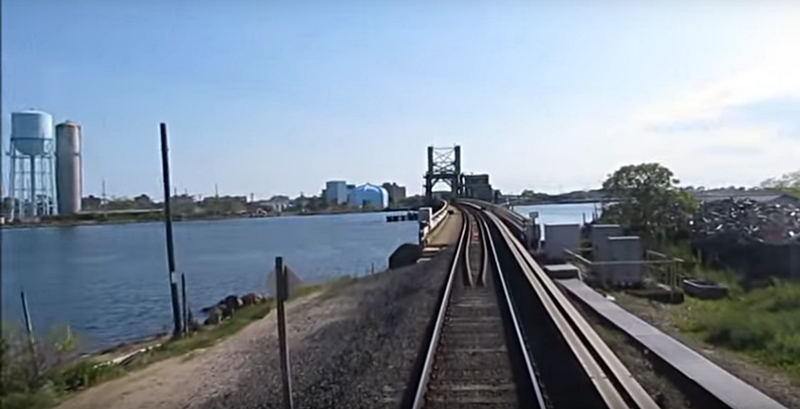
 Train westbound (north) at Reynold's Channel (Wreck Lead bascule bridge) view SE A LIRR eastbound between Long Beach and Lynbrook across the bascule bridge at "LEAD" tower, Reynold's Channel, east of Island Park Photo: unknown |
 Wreck Lead Bridge northern end - view W - Train heading eastbound (south) to Long Beach
The bridge at LEAD was named "Reynolds
Channel Bridge" Reynolds Channel Drawbridge Medallion
1988 - The handout was given to me by a LIRR official. I believe it
was made only for RR officials and probably the contractors who did the
work. The metal is glued onto a beveled glass disk which is clear,
very light weight and 3 inches in diameter. Archive/Info: Carol
Mills |
||||||||||||
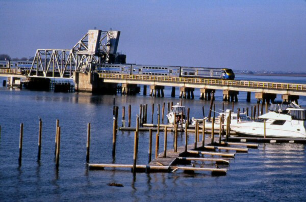
 Wreck Lead bascule bridge 9/05/2014 View W Photo: Jordan Torregrosa |
 M1 crossing Wreck Lead bascule bridge - Summer 1988 - Archive: LIRR/MTA |
||||||||||||
|
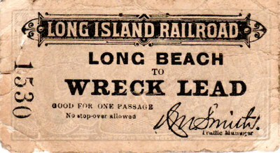
The channel was once called "Wreck Lead Channel" (Click link to Telegraphic Call Letters page for WL, Wreck Lead and Lead) and the location was listed on employee timetables as "Wreck Lead". The original cabin/tower that was built there was thus called "WL" (Wreck Lead). A station was also built there using the same name and appeared on timetables. It was short-lived, and was removed, but there has been a cabin/tower there ever since. Research: Dave Keller |
|||||||||||||
 A LIRR DE30ac locomotive is pulling a special, daily shuttle westbound between Long Beach and Lynbrook across the bascule bridge at "LEAD" tower, Reynold's Channel, east of Island Park in November, 2012 in the aftermath of Hurricane Sandy. The Long Beach branch is normally a third-rail-powered line, but the diesel shuttle service was put into place as the power had to be cut off to the third rail since so much of the line was under water. (George Povall photo, Dave Keller archive) |
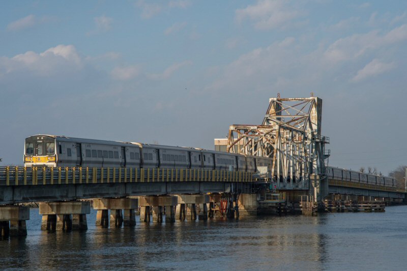 Train #6854 (Penn Station-Long Beach), with M7 7030 (Bombardier Transportation, 1/2003) up front, crosses the Wreck Lead Drawbridge west of Long Beach station in this view northeast. This was a former Florida East Coast drawbridge that was floated up here and installed back in 1988. This replaces a timber trestle that was even lower to the water line! 2/26/2023 Photo/Archive: Jeff Erlitz Consist: 7030-7029+7132-7131+7264-7263+7038-7037+7528-7527 |
||||||||||||
|
The Bascule Bridge is from
Florida and was barged up. The Tower is called Lead Tower or simply
"Lead", and it controls the tracks between east of Island Park
RR Station and into and out of Long Beach yard and also, in conjunction
with the Coast Guard and marine band radio, raises and lowers the bridge
for marine traffic in Reynold's Channel...the LIRR's LEAD Tower Block
Operator controls everything and has a liaison with the Coast Guard when necessary. |
|||||||||||||
| LONG BEACH | |||||||||||||
|
LONG BEACH: WOODEN FRAME STRUCTURE WITH
CLOCK TOWER BUILT: 1880 ON THE BEACH SAND WITH WOODEN WATER TANK AND
CONCESSION STAND |
|||||||||||||
 .jpg) Robert M. Emery hand-drawn map of Long Beach from a 1908 LIRR map. Notice the proximity of the original 1880-era station building to the shoreline and how much further south it was than the present-day, 1909-era terminal building.
|
 Robert M. Emery hand-drawn map of the branch continuation that extended from the 1880-era depot on the sand eastward to Point Lookout. This map is c. 1892 and the tracks to Point Lookout were abandoned in 1895. |
||||||||||||
|
|
.jpg) Robert M. Emery hand-drawn map of the Long Beach terminal facilities MP22.38 as they appeared in 1958. Note that the team yard and freight station is no longer in existence, having been removed in 1943. The curvature of the original right-of-way is still indicated.
|
||||||||||||
.jpg) LIRR track capacities maps Long Beach pre-1962 and post-1962 (LIRR documents, Dave Keller archive) |
|
||||||||||||
.jpg) Long Beach LIRR #55 D53b and White Hats Crew c.1890 Archive Art Huneke |
|
||||||||||||
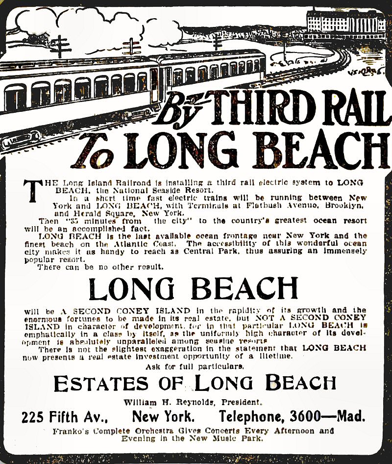
.jpg) This is an extremely rare glass-plate produced image of the original 1880 Long Beach depot building sitting on the sand of the beach in 1892. This view looking northwest is the rear of the station and it faces the water. Note the depot does not have a sign that reads "Long Beach" but, rather, one that reads "R.R. Depot." I guess people confused the structure with Carvel or some other place! Note the wonderful clock tower with a clock face in each of the three directions! Also note the lone house standing in the right background which I estimate to be approximately the location of the newer, 1909-era depot. Other than that, it would appear that Long Beach was quite barren back in 1892! |
.jpg) Taken the same day by the same photographer on a glass plate negative is this view looking northwest showing the outstanding wooden-framed water tank! Notice that Emery's 1908 map posted on this page shows the water tank and pump house north of the tracks. Sometime between this 1892 image and the 1908 map, this picturesque water tank was demolished and its replacement built across the tracks from this location. Note a portion of the station building at the far right, so you can see the relationship between the depot building and water tower. Also note the boardwalk heading towards the water's edge as well as a covered snack bar with what appear to be urns . . . possibly of coffee as well as iced tea.
|
||||||||||||
.JPG) Long Beach Station View NW c.1910 Photo: Unknown
|
.JPG) Long Beach Station and floor plan View NW 6/08/1910 Photo: Unknown |
||||||||||||
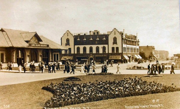
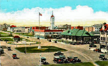
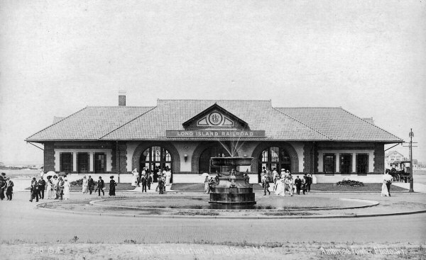 Long Beach Station 1909 Photo: Ambrose Fowler - Archive: Dave Morrison  Long Beach Station colorized postcard Postmarked 1913 - Archive: Dave Morrison |
 Long Beach Station Fountain close-up 1909 Photo: Ambrose Fowler Archive: Dave Morrison |
||||||||||||
 Long Beach Station View NE c.1910.Photo: Ambrose Fowler |
.jpg) We now move to 1924 and parked out front of the 1909-era station building at Long Beach is Railbus #13 of the Long Beach Railway Company. This view is looking northeast. |
||||||||||||
 Long Beach Station. Park Street, c.1930 |
.jpg) By the time I photographed the Long Beach station in 1967, there was no way to take a photograph of the street-side of the building. The beautiful entrance with curved windows and fancy brickwork had been built-over sometime around 1964 or earlier with storefronts which blocked the entire street-side of this once-beautiful structure! This view looks southeast and shows a portion of that storefront at the far right, part of which housed, at the time, a Western Union office and a sign identifying this as the LIRR's station mounted on its roof. |
||||||||||||
.jpg) Also photographed in 1967 was the former express office which was located behind the depot and is indicated on Emery's maps. This view was looking northeast towards the station platforms |
 Long Beach Baggage House ex-Express Office 8/1966 (Sturm-Fehn) |
||||||||||||
 Looking north from the bumpers at the depot building, MU trains of mixed equipment are laid up at the platform for tracks 2 and 1. Construction for the installation of high-level platforms is underway in this 1968 view. (W. J. Edwards photo, Dave Keller archive) |
.jpg) I worked as an extra ticket clerk at Long Beach on July 11 and 12 of 1972. On one of those two days I photographed the ticket window that I worked as well as my ticket case. You can see from the style of decor that the ticket office had been remodeled from the original sometime around 1964. |
||||||||||||
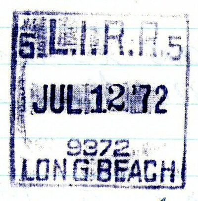 I kept a daily diary of every ticket office I worked and stamped each page with that office's dater die. This is the dater die stamping in my diary from one of the two days I worked the Long Beach station. |
.jpg) Sometime in 1988 or 1989 . . . not sure, a costly restoration was made to the Long Beach terminal building, returning the structure to its original beauty as well as the original style Long Island Railroad (one word!) sign that was displayed street-side. The ugly storefronts were torn away, and the exterior of the depot restored to original condition as-built. This view, taken October 24, 1990 looks northeast, and presents a somewhat busier appearance than images of the same depot when it opened back in June of 1909. |
||||||||||||
.jpg) The restored station looking north on October 24, 1990. Photo/Archive: Dave Keller |
.jpg) The restored station looking northwest on October 24, 1990 |
||||||||||||
.jpg) The covered station platform looking south towards the depot building on October 24, 1990. The old express house from the 1967 image posted above, and which once stood at the far right of this view, no longer exists. |
 "Push Pull" fan trip - Long Beach 3/22/1980 Photo: Brad Phillips |
||||||||||||
.jpg) MU electric train #4845 is railroad westbound, leaving the Long Beach terminal facilities in this view looking southwest on May 20, 1961. Considering the shine, the cars appear to have been recently painted. A double deck car is trailing. (Dave Keller archive) |
.jpg) This is a great overall view of the Long Beach terminal facilities looking south on September 13, 1962. Notice that the depot building still retains the original Spanish roof tiles. Compare the construction to my 1967 image of the depot and some others posted on this page, which show ordinary asphalt shingles replacing the fine Spanish tiles. It's nice to see that the restored station had those roof tiles once again installed. (Wm. Lichtenstern photo, Dave Keller archive) |
||||||||||||
|
|
.jpg) Now a view of the terminal looking in the opposite direction. We see a close-up of a couple of MU electrics at the bumpers photographed on July 30, 1965. Note that the platform for tracks 5 and 6 is low level. Compare with the image following. (Dave Keller archive) |
||||||||||||
.jpg) Now we rotate a little to our right and look at another pair of MU electrics at the bumpers as photographed on August 17, 1968. Note that the platform for tracks 5 and 6 is now a high level one, and of wooden-plank construction. This was necessitated by the arrival on the LIRR's property of the M1 "Metropolitan" cars manufactured by the BUDD Corp. Those cars were not equipped with steps but were designed for high-level platform use only, so the LIRR had to install those type platforms at all their stations in electrified territory that did not already have high level platforms, in preparation for the onslaught of the M1 cars, which would completely replace ALL the old MUs within a few short years. (W. J. Edwards photo, Dave Keller archive) |
.jpg) Looking back towards the station building, which now is devoid of its Spanish tile roof, an MU electric train is laid up on track 7. Notice the platform at the far left, which is depicted in the preceding image, is now high level and no longer of wooden plank construction. It appears to have undergone some changes to make it a permanent platform. This image may be late in 1968 or sometime in 1969, depending on when that high level platform was made more permanent. (W. J. Edwards photo, Dave Keller archive) |
||||||||||||
.jpg) After the new M1 cars were placed on display at several terminal locations in 1968, a fan trip was organized using these new cars. The M1 railfan extra traversed several branches in electrified territory. Here we see it as it's laid up in the yard at Long Beach on April 20, 1969 (Douglas N. Grotjahn photo, Dave Keller archive) |
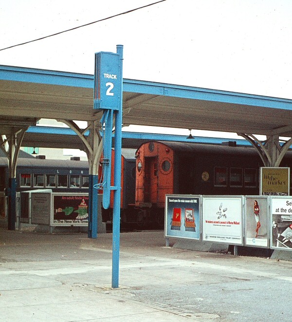 Long Beach - 1966 - Platform gate - Track 2 Photo/Archive: Brad Phillips |
||||||||||||
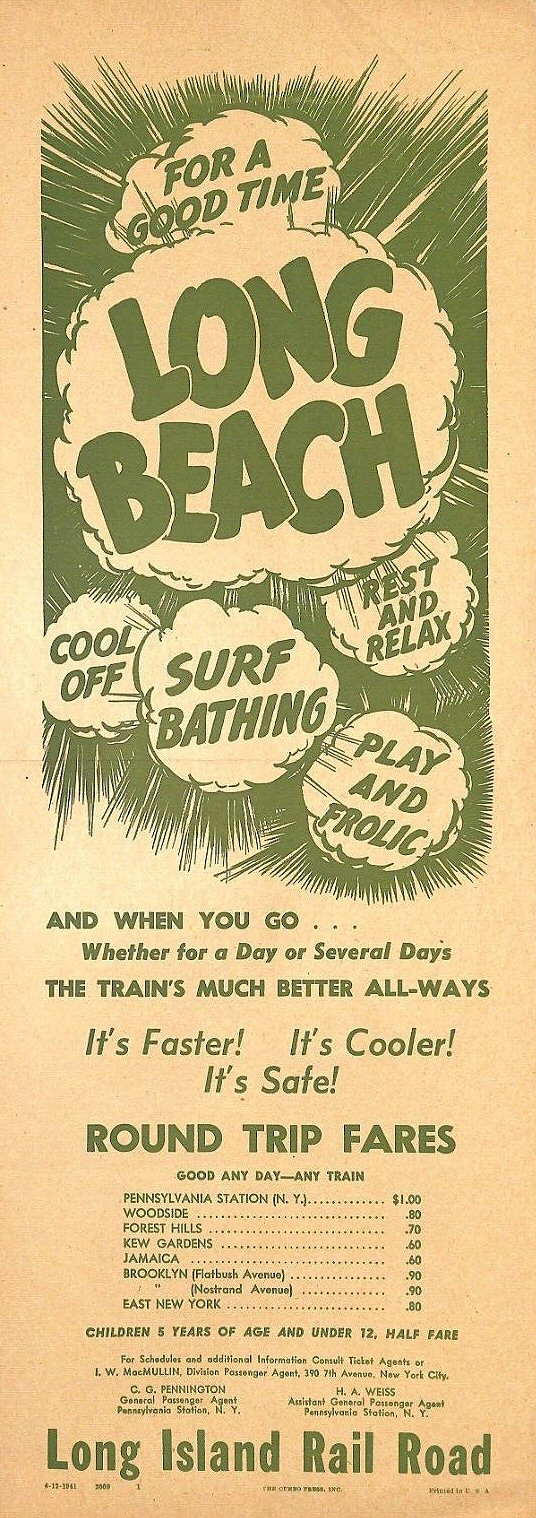 Long Beach Fare Flyer 4/12/1941 |
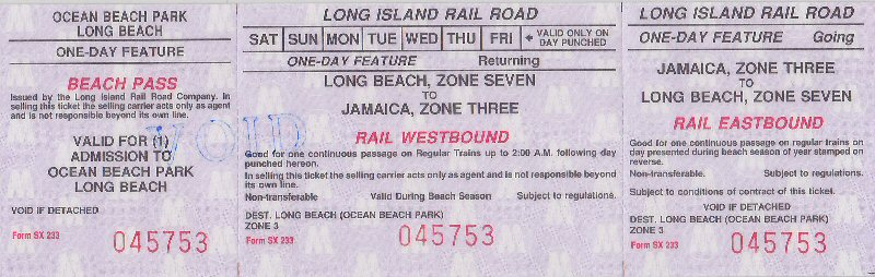 Ocean Beach Park, Long Beach Archive: Kevin Fehn 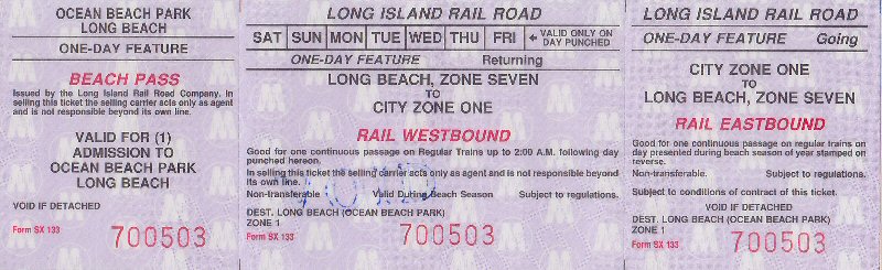
|
||||||||||||
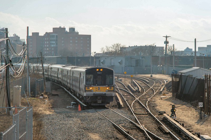 M7 7041 (Bombardier Transportation, 5/2003), with train #6857 (Long Beach-Penn Station), leaves Long Beach station and Yard and a whopping 5 mph, just like at Atlantic Terminal. I can certainly understand having a speed limit that slow coming up on bumping blocks. I feel there is no need to proceed less than 15 mph when departing a terminal if the block is clear. All of the switches here, except for the one on the far right in this view, were converted to controlled switch machines in the past 10 years or so, controlled from Lead Tower on the bridge. This 12-car train was practically at the beginning of double track on the other side of the bridge before it accelerated past 5 mph! That’s one of the yard switch indicators on the right, right in from of milepost 22. View southwest 2/26/2023 Photo/Archive: Jeff Erlitz Consist: 7041-7042+7209-7210+7067-7068+7595-7596+7113-7114+7743-7744 |
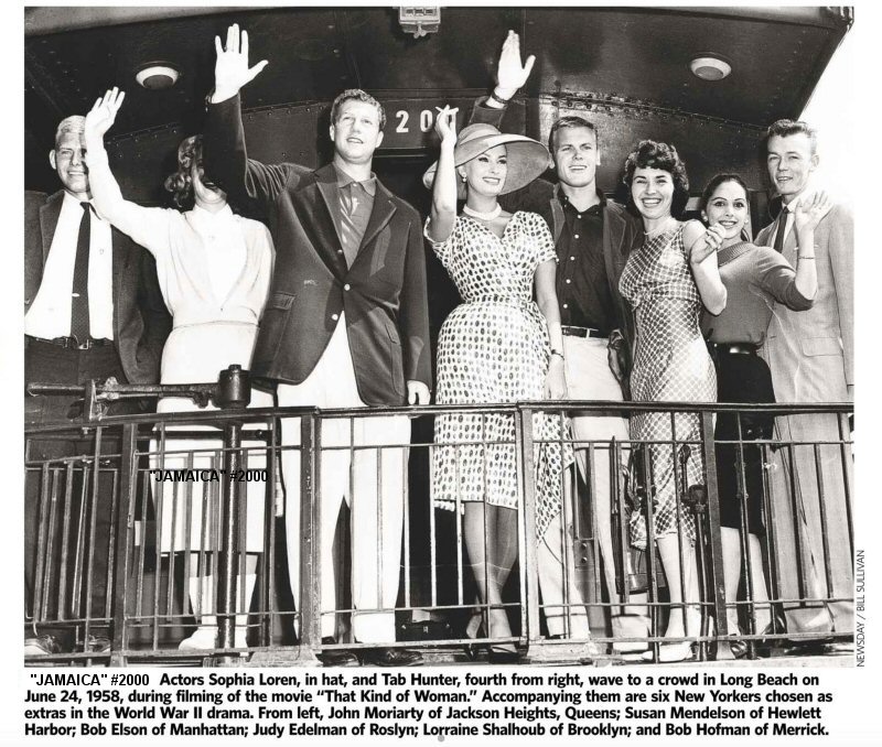 LIRR business/observation JAMAICA #2000 - Newsday 4/30/2023 Actors Sophia Loren, Tab Hunter filming "That Kind of Woman" June 24, 1958 at Long Beach |
||||||||||||
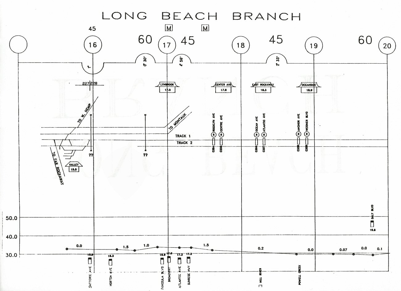 Long Beach Branch - Valley to Oceanside Track profile map 1994 |
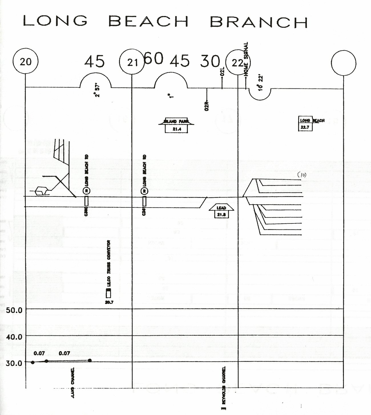 Long Beach Branch - Island Park to Long Beach Track profile map 1994 |
||||||||||||
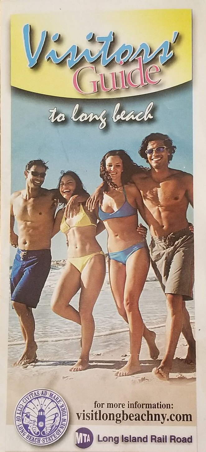
 LIRR Long Beach Visitor Guide 2011 Archive: Kevin Wong |
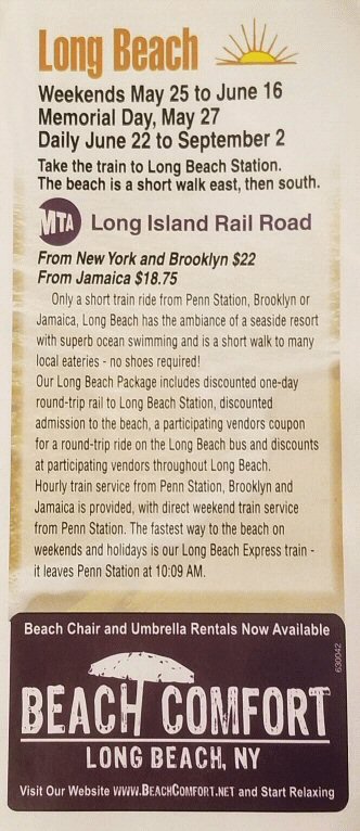 LIRR Long Beach Visitor Guide 2013 Archive: Kevin Wong |
||||||||||||
|
Two LIRR Visitors' Guides to Long Beach, 2011
and 2013. They were distributed by LIRR in conjunction with the Long Beach
Chamber of Commerce and the City of Long Beach and available at ticket offices at staffed stations (I picked them up at Woodside). They included a Long Beach map, local contacts, events listing and ads from local sponsors. Kevin Wong |
|||||||||||||
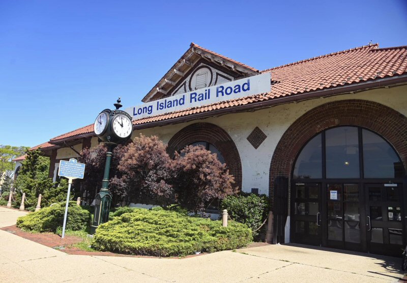 Long Beach Station and historical marker - View NW 2023 MTA |
 Long Beach Station - View N 9/03/2024 Photo/Archive: Joe Vila |
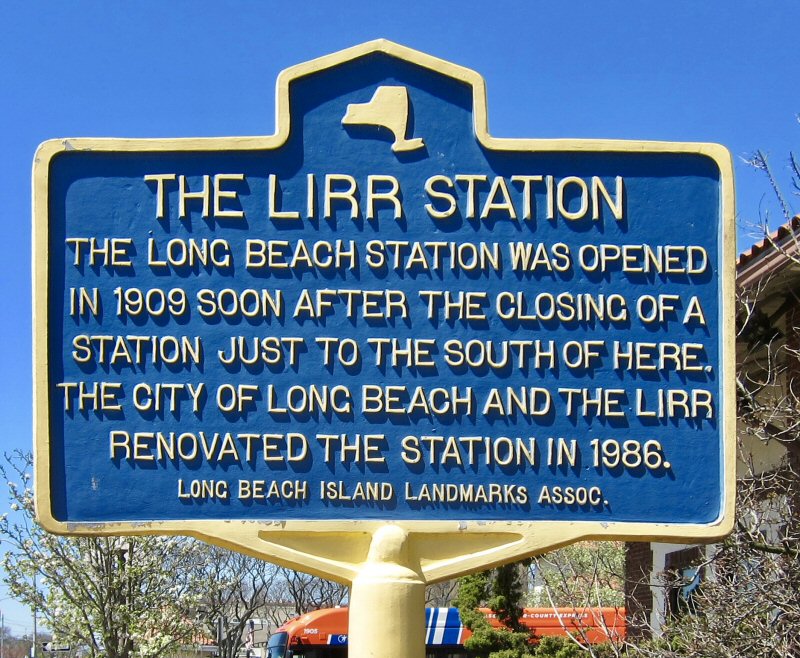 Long Beach Historical Marker 4/24/2019 Photo/Archive Andrew Ruppenstein |
|||||||||||
 |
The tiles on the exterior of the Long Beach Station are from the Moravian
Pottery and Tile Works in Doylestown, PA, confirmed by two tile
historians: Vance Koehler, curator at Moravian and Susan Tunick, Friends of
Terra Cotta. The tiles are among those illustrated in “Moravian Tiles,” a reprint of the 1913 Sales Catalogue of the Tile Works published in 1999. Research: Joe Taylor - Tile Heritage - for research and preservation of ceramic surfaces. Photos/Archive: Dave Morrison 11/28/2024 |
||||||||||||
 |
 |
 |
|||||||||||
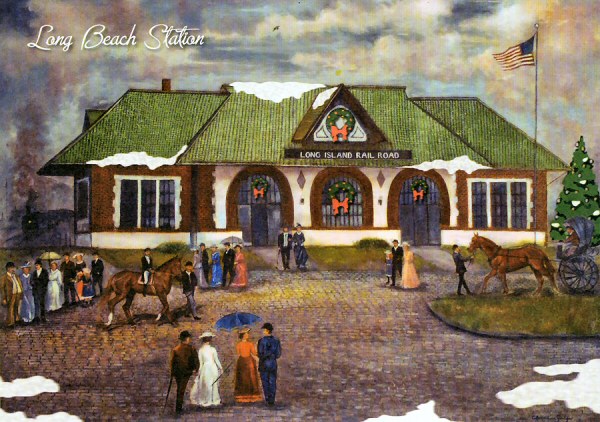 Long Beach Station painting for a LIRR Christmas Card 2011 |
|||||||||||||

%20(E.P.%20Frost%20Agent)%20-%2006-03-1882%20(Keller).jpg)

.jpg)
 OPENED:
5/1/15, BURNED: c. 1958-59
OPENED:
5/1/15, BURNED: c. 1958-59 
%20(HiRes).jpg)
%20-%2002-05-78%20(Madden-Keller).jpg)
%20-%2005-15-88%20(Erlitz-Keller).jpg)


.jpg)
.jpg)
.jpg)