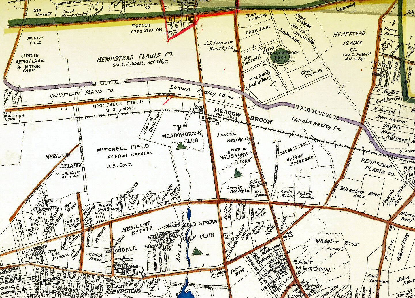
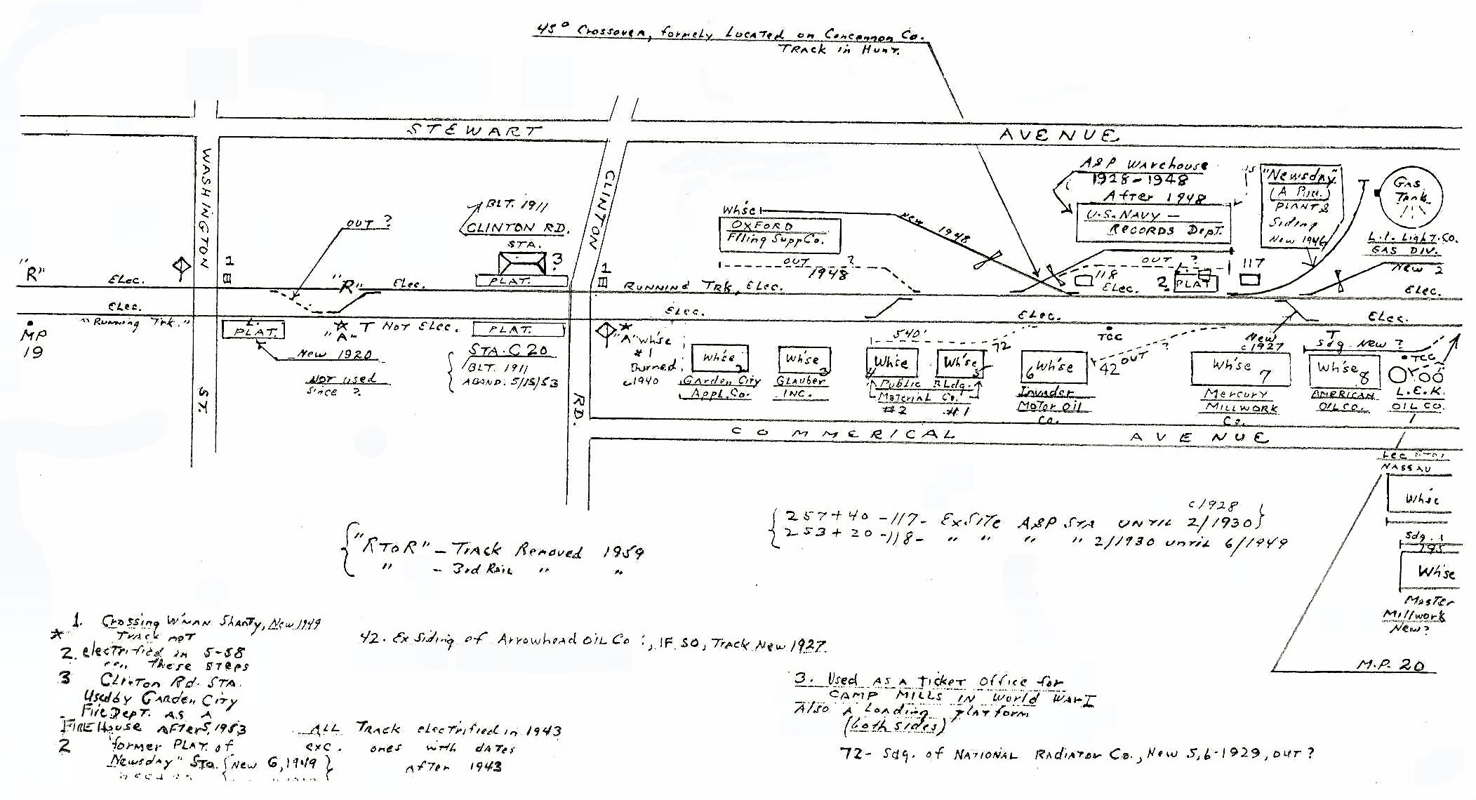
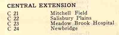
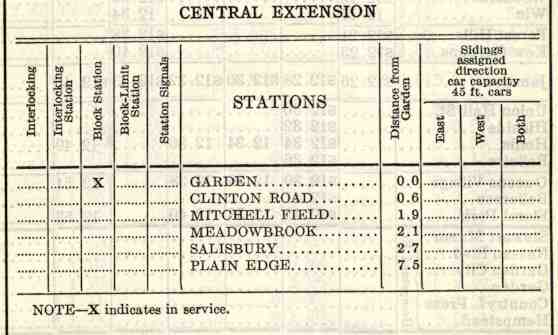
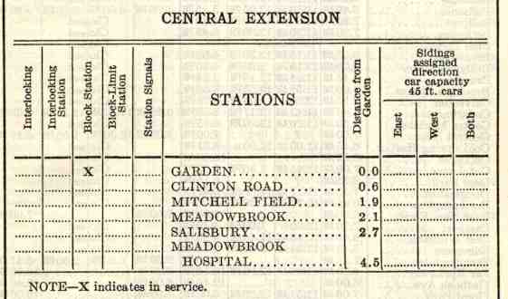
Central
Branch/Hempstead Branch /Central Extension/Garden City Secondary
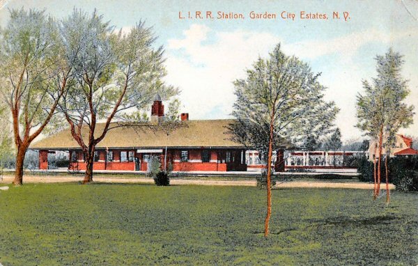
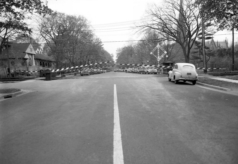
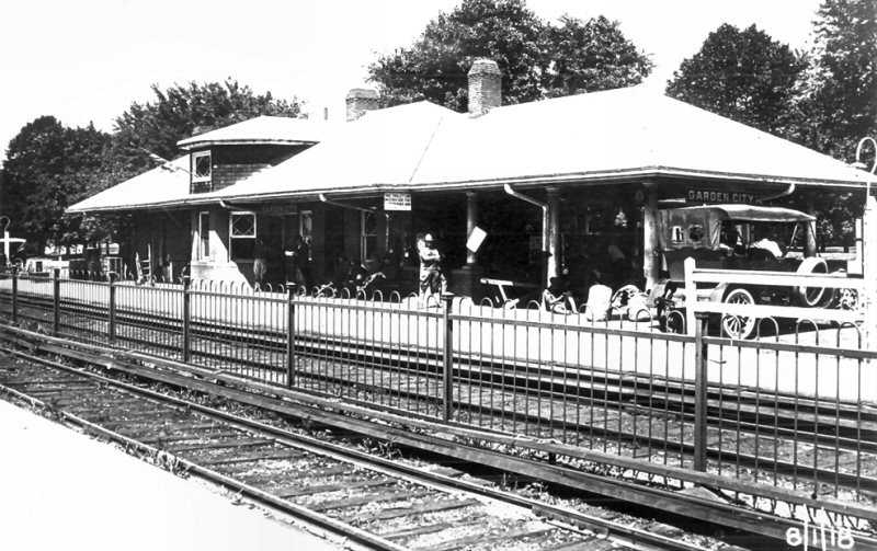
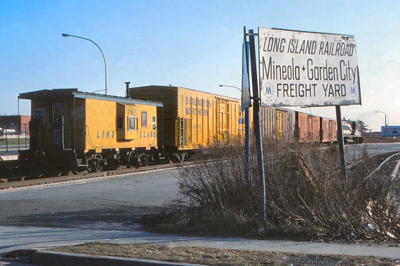
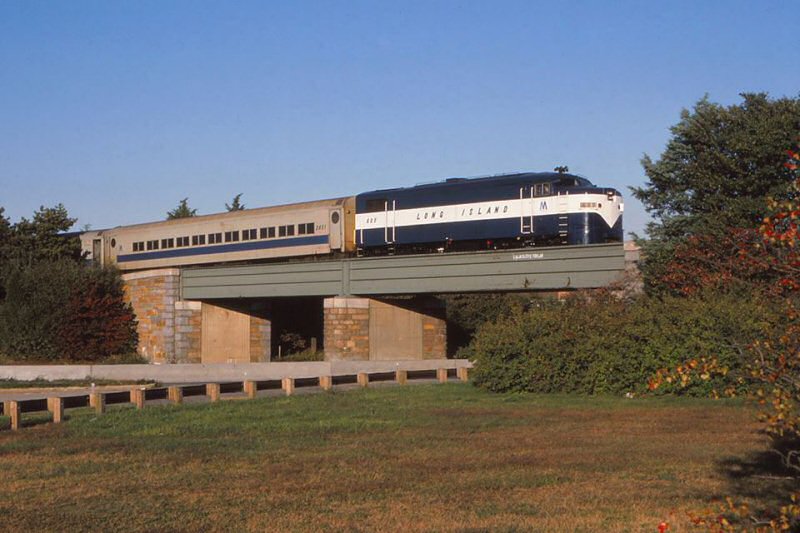
Nassau Blvd., Garden City Station
- c.1901 colorized postcard View N at MP17.5
Library of Congress - April, 1873
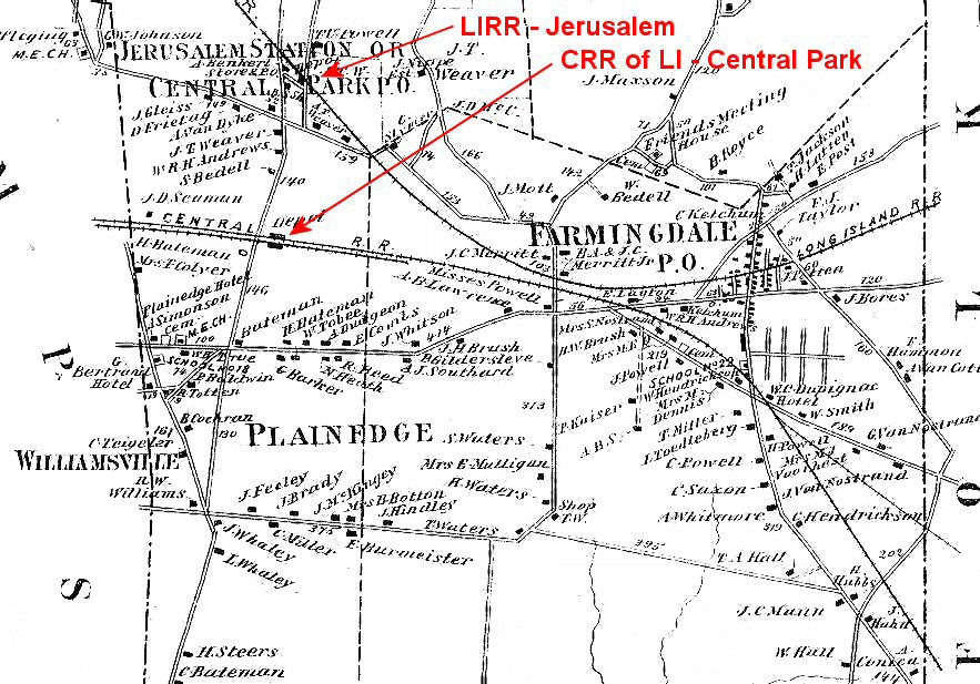
What
is now the LIRR's Hempstead branch, with junction at Floral Park, and
tracks curving south east of the Garden City station, used to be the
property of the Central Railroad of Long Island and was known as the
Central branch. Without getting into all sorts of varying and
confusing rights-of-way, mergers and takeovers, I'll simply say this line
ran from what later became the LIRR's Port Washington branch, curving off
at Great Neck Junction, through Central Depot, Central Junction,
Frankiston, Kissena Park, Creedmoor, Hinsdale and Hillside, crossing the
LIRR's Main Line via trestle just east of what later became Floral Park,
continuing on to Garden City then curving south towards Hempstead. The CRR
of LI also extended the branch east of Garden City. Referred to as
the Central Extension, it crossed the LIRR at Bethpage Junction and headed
further east to the Queens County Brick Mfg. Co., brick of which was used
to build Stewart's Garden City and related railroad structures. The
portion of the line going into the brick works was referred to as the
"Bethpage branch." Another part of this extension went
southeast from Bethpage Junction towards Babylon, crossing the LIRR west
of the station and ending at the Babylon town dock. The portion from
Bethpage Jct. to west of Babylon later became the LIRR's Central branch
extension.
GENERAL ORDER: EFFECTIVE 1921: BETHPAGE AND CREEDMOOR BRANCHES AND CENTRAL EXTENSION “HC” TO
BETHPAGE JCT. WILL BE CONSIDERED SIDINGS.
Special
issue ETT effective May 5, 1879. The The timetable indicates Train #15
running eastbound from LI City to Patchogue via the Montauk branch to
Jamaica then the Main Line
to Stewart Jct. and the Central branch to Belmont Jct. and Babylon and on
to Patchogue. In addition, Train #10 running westbound from
Patchogue to LI City via Babylon, Belmont Jct. and the Central branch to
Jamaica and then the Main Line to L. I. City.
Archive: Art Huneke Info: Dave Keller
In
1879, the Central RR of LI abandoned their line from Great Neck Junction
to Creedmoor. The short stub that was remaining between Creedmoor
and what would later become Floral Park was referred to as the Creedmoor
branch. When the LIRR acquired the CRR's tracks, connection was made with
the LIRR's tracks at Floral Park (then known as Stewart Junction) and the
trestle crossing the Main Line was removed.
The
LIRR's original Hempstead branch ran south from Mineola, crossing the CRR
of LI at what was known as Hempstead Crossing and continued on to
Hempstead, paralleling the CRR's ROW into that village. When the
LIRR acquired the Central RR of LI, the Central branch became the LIRR's
Hempstead branch, curving south just east of Franklin Ave., Garden City,
heading to Hempstead, where the LIRR abandoned their terminal building in
favor of using A. T. Stewart's nicer, all brick structure. "HC"
tower was erected at Hempstead Crossing in 1890 as "Tower 44"
and controlled traffic along the two branches. In later years, stops were
added at Stewart Manor, Nassau Blvd. as well as at Country Life Press to
provide access for employees of that so-named magazine.
In
later years the tracks heading east were cut back to just east of
Salisbury Plains station with shuttle service operating between there and
Country Life Press, using Ocean Electric streetcars operating off the
third rail. Stops were made at Washington St., Clinton Road, A&P,
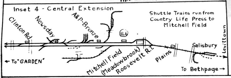
Mitchel Field, Meadowbrook and Salisbury Plains. (Other stops were later
added at General Bronze and Newsday.)
In
1937, "HC" tower was renamed "GARDEN" tower and two
years later, the tower and the crossing were removed. A replacement
block station was constructed in the form of "GARDEN" cabin at
Franklin Ave., west of the former track crossing.
The
tracks were cut back again, this time to Meadowbrook, but shuttle service
stopped at Mitchel Field. The streetcar shuttle was replaced with an
MP41 MU car, later expanding to two MP41 MU cars, which were later
replaced by two MP54 MU cars. The shuttle service, which primarily was for
employees of the various industries along the line, and which only
accepted cash fares (no ticket sales) ended in 1953.
The
branch extension came back to life when Roosevelt Raceway trains ran to
Meadowbrook in the late 1950s where buses took riders to the racetrack and
back. Years after the raceway trains ended, the tracks were cut back once
again and terminated on the west side of Endo Blvd. west of what was once
Mitchel Field. (Dave Keller data)
Station/MP/Location order after leaving Floral Park:
Plainfield Ave.
Stewart Manor
Nassau Blvd (Garden City)
Garden City
"GARDEN" cabin at Franklin
Ave.
"HC" tower at Hempstead Crossing
Washington St. (shuttle station stop)
Clinton Road
A&P / Newsday
General Bronze (Later A&P/Bronze)
Mitchel Field
Meadowbrook
Salisbury Plains
Bethpage Jct.
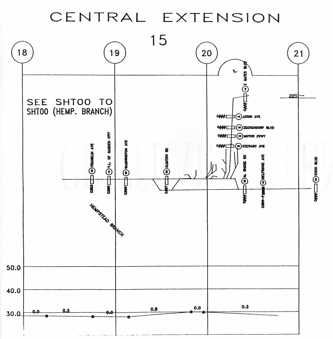
Central Extension Garden City Track profile map 1994
PLAINFIELD AVE., FLORAL PARK
MU Train #4739 westbound Hempstead Branch Plainfield Ave - Grade
Elimination Floral Park 6/04/1961
MU Hempstead Train East Hempstead Branch passing PARK
Tower Floral Park
1950
Crossing Shanty and Power Grid Plainfield Ave. Floral Park Hempstead
Branch View NE 10/12/51 (Faxon-Keller)
MU Train Layup Track Plainfield Ave.
view E Floral Park 10/12/36
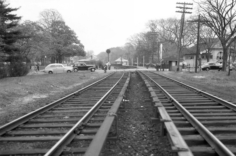
Station crossing Shanty Nassau Blvd, Garden City view W 1948 (Weber-Morrison)
MU double decker #1346 with 5 car train west at Nassau Blvd,
Garden City 9/14/48 (Hermanns-Keller)
Nassau Blvd. crossing view N 1948 The station is left beyond photo.
(Weber-Morrison)
Nassau Blvd crossing view S. Access to Nassau Blvd. station parking lot at
right. 1948
(Weber-Morrison)
Nassau Blvd Station view SW 10/16/2016
Photo: Dave Morrison
Nassau Blvd Station cupola weather vane 10/16/2016
Photo: Dave Morrison
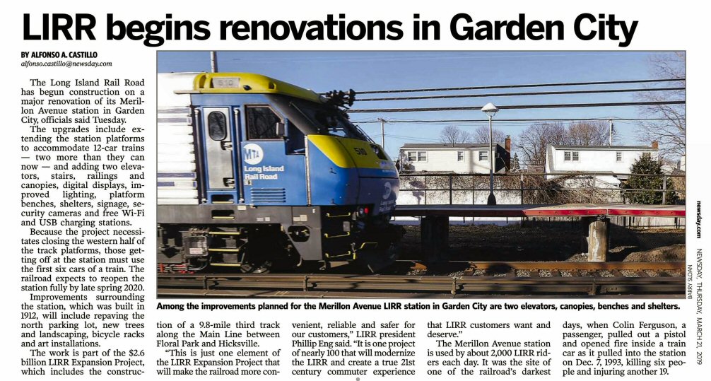
Garden City renovations - Newsday 3/21/2019 Archive: Dave Morrison
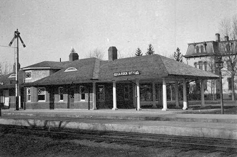
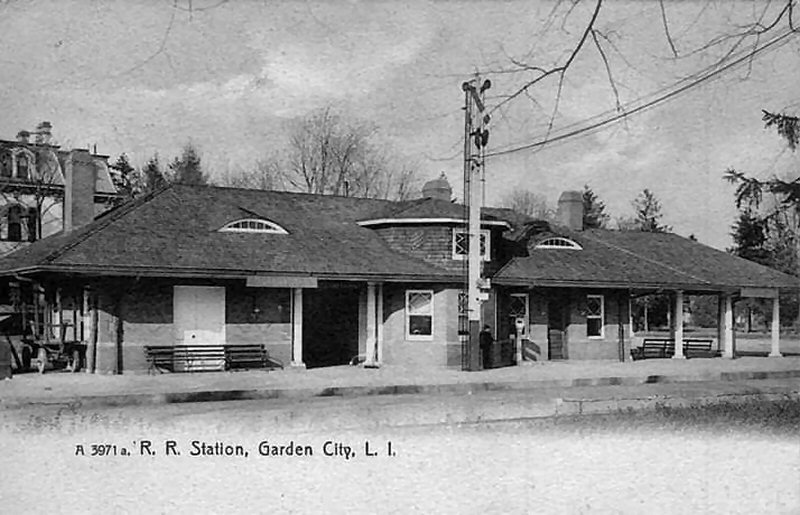
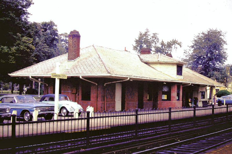
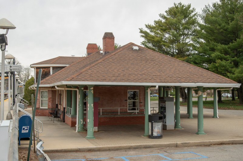
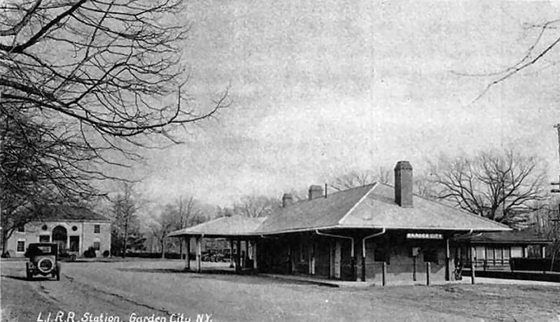
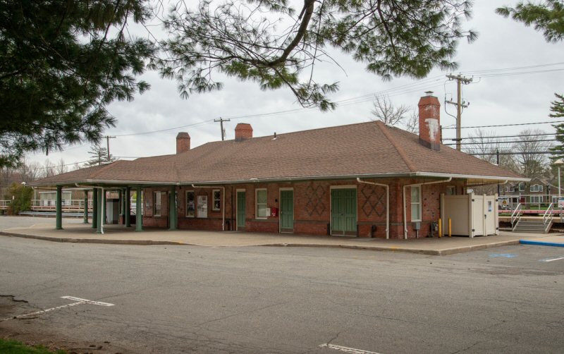
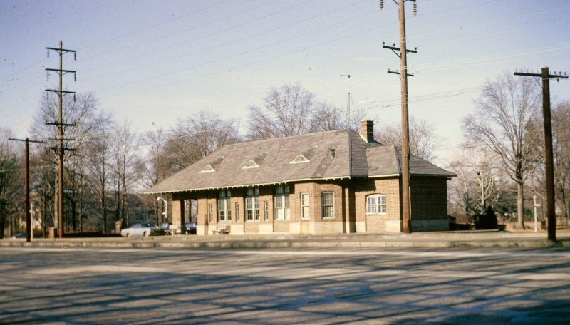
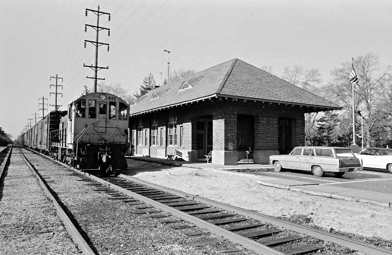
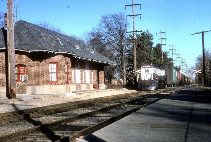
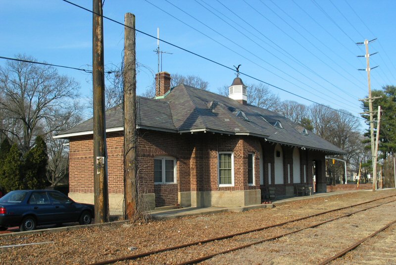
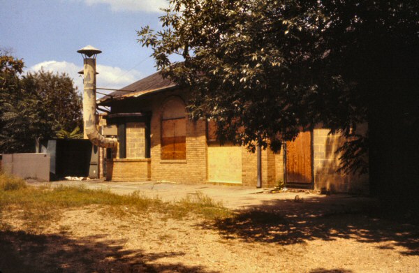
GARDEN CITY STATION
CRR OF LI DEPOT BUILT: OCT/1872-APRIL/1873. CLOSED: 1898
2ND DEPOT BUILT: 8/1898. AGENCY CLOSED: 11/20/1996 Research: Dave Keller
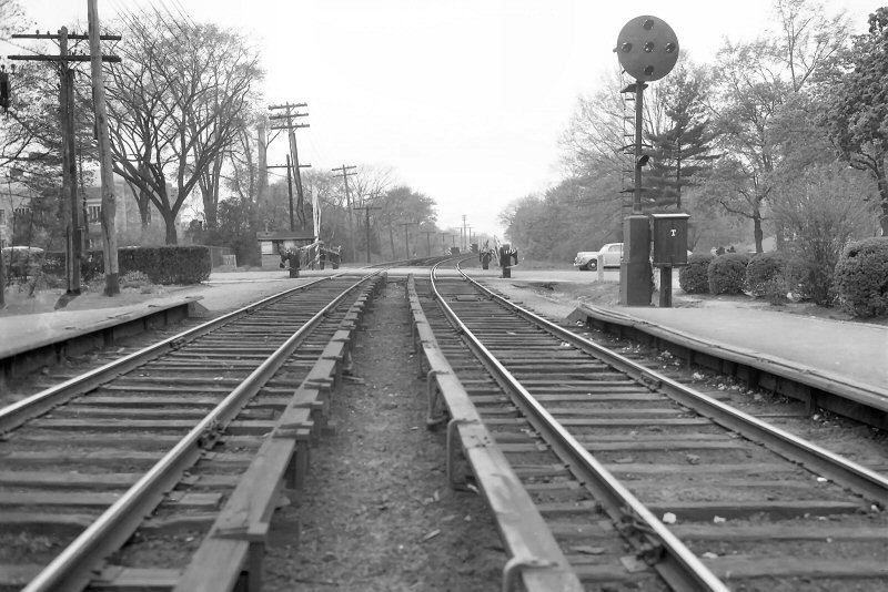
Cathedral Ave. crossing view N 1948
(Weber-Morrison)
Cathedral Ave. crossing view S 1948 Cathedral of the Incarnation
in right background. (Weber-Morrison)
Cathedral Ave. crossing view east towards Garden City station. 1948
(Weber-Morrison)
Cathedral Ave. crossing view west from end of Garden City station
platform. 1948
(Weber-Morrison)
Garden City Station CRRLI view E 1878
Photo: George Brainerd
Archive: Dave Keller
Garden City Station - View NW c.1900
Archive: Dave Keller
Garden City Station CRRLI view W 1878
Photo: George Brainerd
Archive: Dave Keller
Garden City Station - View N c.1904
Garden City Station CRRLI view S c.1878
Archive: Dave Keller
Garden City Station - View NE
8/1967 (Sturm-Fehn)
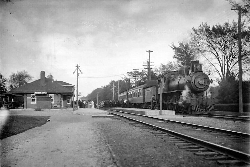
D16b #217 Special Train (flying white "extra" flags on the smoke box)
westbound at Garden City Station 1907 (pre-1908 electrification) Photo:
Brown Bros. Archive: Dave Keller
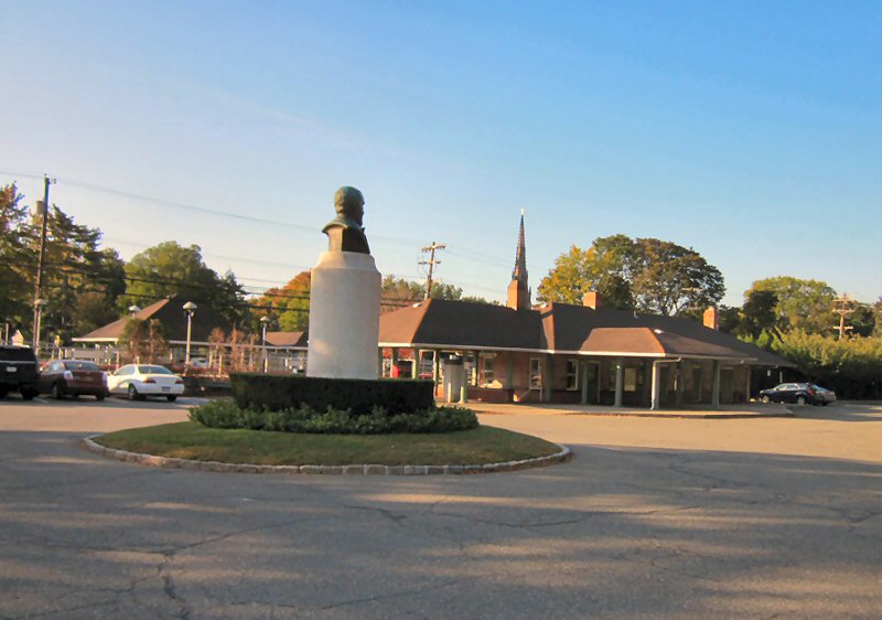
Garden City Station - Stewart monument view SE 10/16/2016
Photo: Dave Morrison
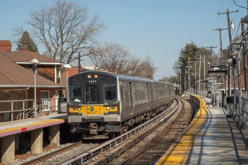
Garden City Station M7 #7473 - View E
4/07/2023 Photo/Archive: Jeff Erlitz
Garden City Station - View W
4/07/2023 Photo/Archive: Jeff Erlitz
Garden City view c.1904
Garden City Station opened in 8/1898 and the agency closed 11/20/1996.
However, the waiting room is still open seven days per week.
Note: The
baggage/parcel room on this end. View SE 4/07/2023 Photo/Archive: Jeff
Erlitz
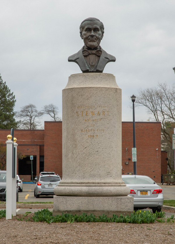
Alexander T. Stewart monument
Photo/Archive: Jeff Erlitz
Alexander T. Stewart, founder of Garden City, which
occurred in 1869. He built and presided over the Central Railroad of Long
Island. The railroad was established in 1871, then merged with the
Flushing and North Side Railroad in 1874 to form the Flushing, North Shore
and Central Railroad. Today’s Hempstead Branch between Floral Park and
Hempstead Crossing (east of Garden City station) was originally the
Central Branch. He also owned the eponymous department stores. He was,
supposedly, one of the three wealthiest men in America at the time,
alongside Cornelius Vanderbilt and William B. Astor. Info: Jeff
Erlitz
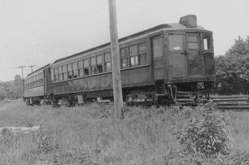
The Central branch between "HC" (Hempstead Crossing) in
Garden City and Salisbury Plains was electrified in 1917.
That
year, 3 ex-Ocean Electric trolley cars were converted from trolley to
third rail service and operated as a shuttle (one car at a time) between a
layup track opposite the Garden City station and Salisbury Plains, making
a stop at Mitchel Field (yes, "Mitchel" with one "L"). This shuttle ran
until 1927.
On 10/31/1927, the shuttle was moved to a layup track at Country Life
Press and all shuttle service then operated between there and Salisbury
Plains. In 1928 the Ocean Electric cars were withdrawn from service and
replaced at first by one MP41 MU car, then two MP41 MU cars (2-car train),
and finally, two MP54 MU cars (2-car train)
Service was cut back to Mitchel Field during WWII, because the trip to
Salisbury Plains ran through secure government territory. The field was
fenced off and trains /ex-trolleys were no longer allowed to run past
Mitchel Field station so Salisbury Plains station was closed.
Photo: Ocean Electric Car #29 at Clinton Road, Garden City 1918 Archive:
Dave Keller
The last passenger shuttle trip ran between CLP and Mitchel Field on
5/15/53. Research: Dave Keller
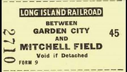
A ticket from a monthly ticket book for the Mitchel Field shuttle. c.1925
In the last years of shuttle service, tickets were NOT
sold. Riders paid cash. I believe the fare was $ .25. On-train tickets
were not issued. . . it was simply hand the trainman or conductor a
quarter and I believe it was the same whether you went to Mitchel Field or
closer stops like Newsday and A&P Bronze (since 6/1949).
The ticket is printed Garden City to "Mitchell" Field
(incorrect as it's
"Mitchel" field . . . one "L"). This was not the end of the line in the
1917-1927 years of operation. It was but one of several stops on the way
to the truncated branch at Salisbury Plains.
Based upon the dates I've provided above, this ticket would have been
issued at the Garden City station anytime between 1917 and 1927. Riders
would have walked across the tracks at Garden City and got on the
ex-trolley car to Mitchel Field and /or Salisbury Plains.
It's possible that once the cars operated between CLP and Salisbury,
printed tickets were issued at the CLP station beginning in 1927, however
the agency was closed by 1940, so I'm assuming only cash fares were
accepted after that, if shuttle tickets were ever issued at CLP. It was
quite a walk from the shuttle's layup track and platform to the ticket
office at CLP. Research: Dave Keller
Garden City station - View NW 8/01/1918
(LIRR Valuation - Art Huneke)
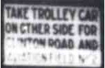
The
inset sign tells riders to take the trolley on the other side of the
station, where the layup track was originally located:
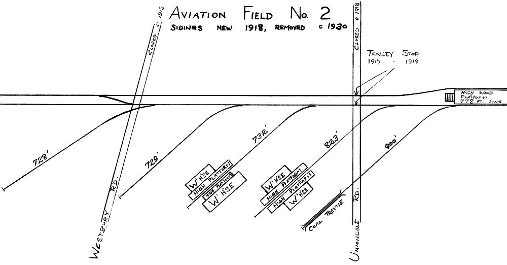
"TAKE TROLLEY CAR ON OTHER SIDE FOR CLINTON ROAD AND AVIATION FIELD No. 2"
Note: Aviation Field No. 2 was the prior name of Mitchel
Field. Info: Dave Keller
Garden
City Station and Salisbury Plains Shuttle
An aerial view of Country Life Press looking east in 1928,
the last year that the ex-Ocean Electric trolleys that were converted to
third rail operation were used in shuttle service to Salisbury Plains
station east of Mitchel Field. The cars had been relocated from the Garden
City station the previous year, to the very north end of the Country Life
Press station. In this photo, we see the historic Country Life Press
building in the foreground, from which the nearby railroad station derived
its name. Behind it, from left to right, is the straight track heading to
Hempstead Crossing and which connected Mineola and Hempstead, and Mineola,
West Hempstead and Valley Stream. In front of this track we can just make
out the west leg of the wye which is the track between Garden City and
Hempstead. Behind the straight track is the curving east leg of the wye
which connected with the Central branch. An ex-Ocean Electric car is
laying up at the platform. To the right of the car is the platform shelter
and then following the very long platform southward (railroad eastward) we
see the Country Life Press depot at the very far right. The track directly
in front of it continues on to the terminal in Hempstead and the track
branching away from it led to West Hempstead and on to Valley Stream. It
was quite a walk from the depot to the shuttle so I'm not sure tickets for
the shuttle were ever sold at that agency. They may have been, with the
shuttle entering the station to pick up riders but if that were so, what
was the purpose of a wooden platform and shelter constructed at the very
north end? (Dave Keller archive and data)
This
is a zoomed-in image of the shuttle and shelter. You can see that the
wooden platform extended even further north of where the car was laying
up. After 1939 when Hempstead Crossing was eliminated, the track to
Mineola was cut back south of the Central branch and former crossing to
about where this platform ended and the shuttle then laid up on THAT track
in lieu of its former layup spot on the wye track. It would then head
south (railroad east) to clear the switch, then head east on the wye track
to Salisbury Plains station.
MP41 #1100 as Mitchel Field one-car shuttle at the shuttle lay-up track
just north of the Country Life Press station. View is NE. The old CRR of
LI brick water tower at Hempstead Crossing is visible in the left
background and the main through-track to and from Hempstead Crossing is in
the foreground - c. 1933 (George Arnoux photo; Dave Keller archive)
MP41 #1101 - Mitchel Field - One car shuttle -at Country Life Press -View
NE- 4/05/1934 (Votava-Keller)
MP41 #1100-1101 - Mitchel Field Shuttle at east leg of Wye - Country Life
Press-View NE
c.1938 (Winslow-Keller)
MP41 #1100-1101 at Country Life Press 1942
MP41 #1100-1101 - Mitchel Field Shuttle at Clinton Rd. Station - View NE
3/25/1947 (Hermanns-Keller)
MP41 #1100-1101 - Mitchel Field Shuttle north of Country Life Press -View
SE 3/30/1947 (Hermanns-Keller)
MP41 #1101 Interior - Country Life Press
5/30/1949 Archive: Dave Keller
After practically all of the MP41 MU cars were taken out
of passenger service, the last few were used on the shuttle. They, too,
were eventually withdrawn from service and were replaced by two MP54 MU
cars. Here's a peaceful view from the summer of 1949 with puffy,
fair-weather clouds in the sky looking NE. It shows the 2-car shuttle of
MP54 MU cars consisting of car #s 1762 and 1943, coupled, and laying up on
the truncated segment of the former Mineola to Hempstead track. Note both
cars are in the PRR Tuscan Red color scheme with Dulux gold lettering and
the car at right has what appears to be an aluminum-painted roof, designed
to reduce the summer's heat in the car. The rail visible at the very
bottom of this image is that of the Hempstead branch between Garden City
and the terminal at Hempstead. (W. J. Edwards photo, Dave Keller archive)
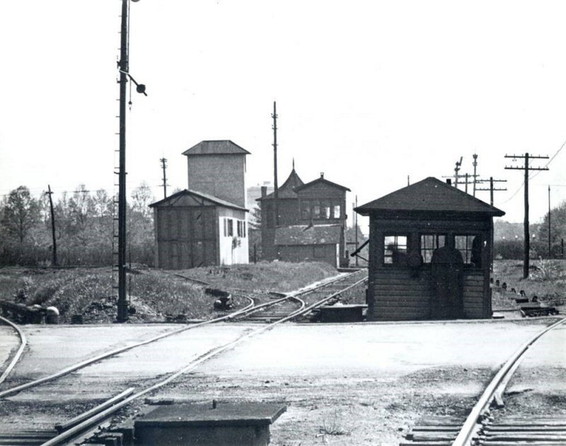
"B" CABIN
Franklin Ave., Garden City Central Branch - View E c.1930 Archive: Art
Huneke
“B” CABIN: CROSSING WATCHMAN’S CABIN - GARDEN CITY (EAST SIDE OF FRANKLIN AVENUE, BETWEEN CENTRAL AND HEMPSTEAD
BRANCHES, BUILT WITH A 2-LEVER DWARF INTERLOCKING MACHINE CONTROLLING DERAILS AND DWARF SIGNALS
ON THE N.Y. & L.I. TRACTION CO. TRACKS ON FRANKLIN AVENUE. INTERLOCKED WITH “HC” TOWER. IN SVC: 1920s.
OUT OF SVC: 1/27/39 WITH OPENING OF “GARDEN” CABIN.)
The watchman in "B" cabin lowered the
gates and operated the derails for the trolley which crossed the tracks
but did not handle the block although the cabin was interlocked with the
distant tower "HC" tower, which did handle the block. "B" cabin only had
a crossing watchman. "HC" tower (renamed "GARDEN" in 1937) had a block
operator.
The trolley tracks and derails were gone from the crossing at the time of this photo. At the far left, the track curving north to Mineola and at the far right, the tracks curving south to Country Life Press and Hempstead. The electrified Central branch is in the foreground.
Research: Dave Keller
At the left center, the siding to access the portable
sub-station storage facility. A portion of the section house is visible at the far right.
Just beyond that, a full view of the section house with "HC" tower at the crossing of the Hempstead branch from Mineola and the Central Branch.
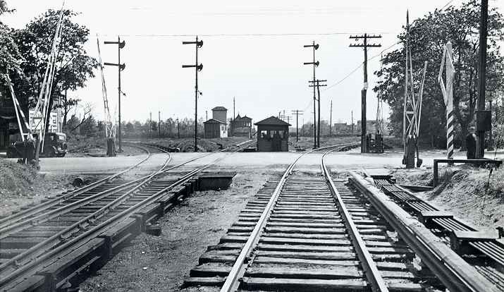
Behind "HC" tower is the all brick water tower dating back to Stewart's construction of Garden City (1870s). Back in the early days of the tower, windmill blades were positioned atop to draw the water up. The tracks for the crossing were located between "HC" tower and the brick water tower.
After 1939, no structures in this image remained and "GARDEN" cabin was constructed at the far left of the overall view, on the west side of Franklin Ave. crossing.
Research: Dave Keller
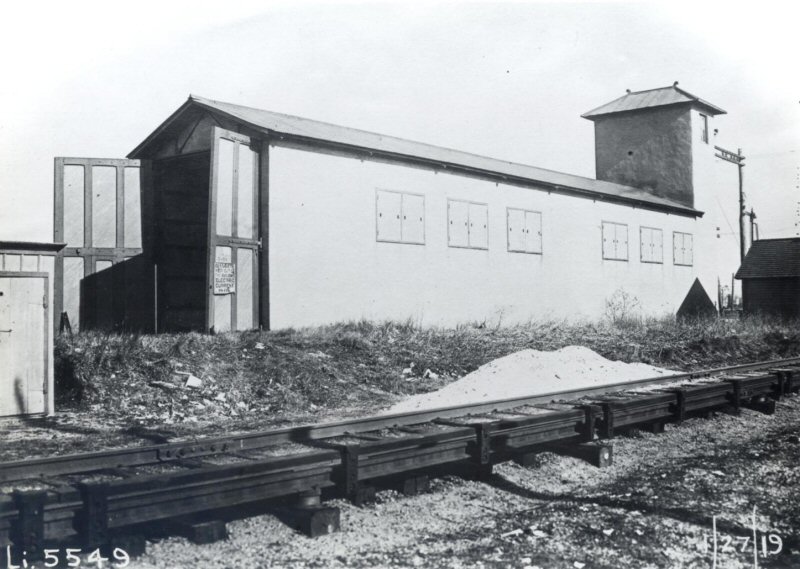
Portable sub-station storage LIRR valuation photo 1/27/1919 Archive: Art
Huneke
Franklin Ave., Garden City previous "B" Cabin location - View E 1975
Photo/Archive: Tim Darnell
GARDEN CABIN
“GARDEN” CABIN GARDEN CITY – JCT. OF HEMPSTEAD BRANCH. OPENED 1/27/39, NORTH SIDE OF TRACKS, WEST SIDE OF FRANKLIN AVE., 650’ WEST OF FORMER LOCATION. OUT OF SVC. BY 6/5/95. RAZED: c. 1999-2000
When "GARDEN" tower was torn down in 1939, "GARDEN" cabin
was constructed where it's shown in my color photo below, taking on the
former role of "GARDEN" tower to handle the block and signals. When
"GARDEN" cabin was in service (1/27/39), there was no need for two cabins a
few feet away from each other, so "B" cabin was removed. The gates,
junction AND block signals would then be operated by the block operator at
the newly-opened cabin. Info: Dave Keller
MOW Crew Car #492755 Work Train at Garden Cabin, Garden City
c.1947 (Votava-Keller)
Garden Cabin with Keystone Sign c.1947 (Votava-Keller)
Cabin GARDEN - Junction of Central and Hempstead Branch View E 5/17/81
(Madden-Keller)
ROW Start of Secondary Track east of Franklin Ave. MP19 Garden City View
E 11/21/1993 (Madden-Keller)
GARDEN Cabin - View E 1969
GARDEN Cabin - Michael secondary track (center) - View W 6/18/1958
Photo/Archive: Richard F. Makse
GARDEN Cabin track to Country Life Press
View W 6/18/1958
Photo/Archive: Richard F. Makse
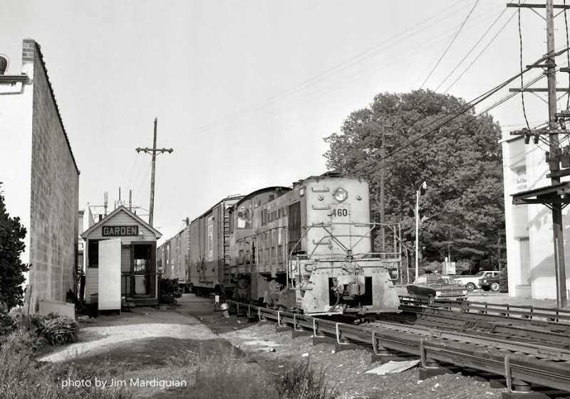
S2 #460 Garden Cabin -1970 Photo/Archive: James Mardiguian
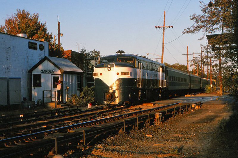
LIRR #605 ERA (Electric Railroaders Assn.) Special westbound at Garden Cabin
10/1986
Franklin Ave. Garden Cabin View W 1975 Photo/Archive: Tim Darnell
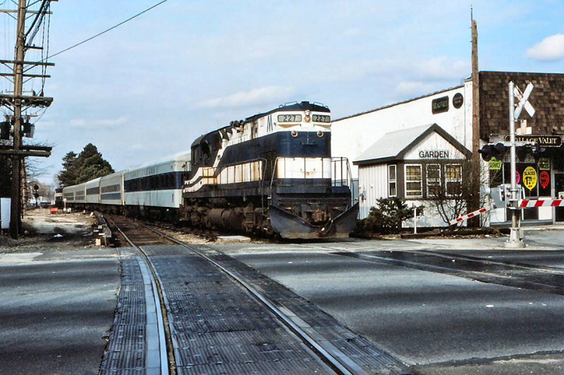
LIRR #227 Garden Cabin - View W 4/1984
Into the setting sun at Garden Cabin, in Garden City, an
Electric Railroaders' Association special (above right) is seen westbound leaving the
Garden-Mitchel Secondary. As it passes the tower, operator Freddie Glenn is
saying hi to the head-end crew of the 605. He will have to manually re-line
the switch for its normal position, the Hempstead Branch, once the special
passes. With so much automation, such personal encounters along the railroad
today are, sadly, very few and far between. Photo/Archive/Info: Jay
Bendersky
The Electric Railroaders Assn. operated a fan trip excursion
over parts of the LIRR. One of its destinations that day was the
Garden-Mitchel Secondary (above right). It is seen here, with LIRR #227 in the lead
eastbound, and the "Morris Park" parlor car directly behind, crossing
Franklin Avenue in Garden City. Normally, weekends at Garden Cabin would be
very quiet, but not this Saturday! The special would visit other LIRR
branches later that day.
Photo/Archive/Info: Jay Bendersky
Renaming
of Secondary Tracks: While the Central Extension appears in the station pages (of employee timetables), from at least 1936 on, the “branch” was classified as a siding, meaning restricted speed. Since the shuttles had no timetable authority (you need to have main track for that), I have to assume that the freights working cleared the “main” when the shuttle was operating. Note that the Central Extension was largely double track so there were many crossovers and turnouts.
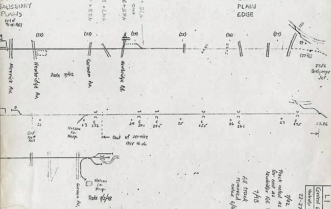
In 1946, (probably also in 45, timetable for which I am missing), the Central Extension was gone from the station pages and the only reference was to a siding in SI 2207 which stipulated that the track extended from Garden to Meadowbrook Hospital. In 1947, in a couple of places in the Special Instructions, was referred to as the Meadowbrook Hospital Siding. (Richard F. Makse)
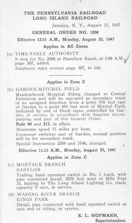
G.O. #1208 eff. 08/25/47 (ETT #12) changes the name of the Meadowbrook Hospital Siding to the Central Extension and states it will be operated as a secondary track between east of GARDEN to west of Mitchel Field. (Art Huneke data)
In the special instructions for Timetable #14 (June 13, 1948) and under Secondary Tracks of No Assigned Direction, Garden to Mitchel Field is called Central Extension. (Jeffrey Erlitz)
ETT #15, eff. 09/12/48 shows Garden-Mitchel Field Secondary Track. (Art Huneke data)
Other than temporary block stations during the Vanderbilt Cup races, I don’t believe the line ever had any signaling. Both Clinton Road and Salisbury Plains did have ticket offices for a short period of time but likely there were no signals since the shuttles were run by the same crew. (Richard F. Makse)
LIRR ETT #12
G.O. #1208 eff. 08/25/47 changes the name of
the Meadowbrook Hospital Siding to the Central Extension and states it
will be operated as a secondary track between east of GARDEN to west of
Mitchel Field. (Art Huneke data)
Henry Raudenbush map insert: Central Extension October 1952
HEMPSTEAD CROSSING
HC TOWER: HEMPSTEAD CROSSING, GARDEN CITY – JCT OF
HEMPSTEAD
BRANCH AND N.Y. BAY EXTENSION (PER 1903 CR4.) (NORTHWEST QUADRANT OF CROSSING.ORIGINALLY
TOWER #44, 36-LEVER SAXBY & FARMER MECHANICAL MACHINE IN SVC:1/1890. WAS RENUMBERED TOWER #105 IN 1894 WHEN BLOCK SYSTEM WAS
EXTENDED EAST.TOWER #44
ASSIGNED BRUSHVILLE.RENAMED “HC” IN 1907. BECAME TRAIN ORDER OFFICE ON 10/01/1907
WHEN
GARDEN
CITY STATION CEASED BEING A TRAIN ORDER OFFICE.INTERLOCKING PLANT INCREASED TO 40 LEVERS:1/28/1919. RENAMED “GARDEN”: 4/30/37.
OUT OF SVC: 1/27/39.
MU Train for Roosevelt Raceway eastbound at Franklin Ave.,
Garden City view SE 1956 (Edwards-Keller)
Crossing Shanty at Franklin Ave., Hempstead Crossing, Garden City
c.1930
Archive: Art Huneke
Site #2: HC Tower and old CRR of LI Water Tower at Hempstead Crossing c.1920
Archive: Dave Keller
Site #19: The old, brick CRR of LI water tank at Hempstead Crossing east of Garden City on 01/27/1919.
View NE Archive: Dave Keller
Central Branch Hempstead Crossing MP19 5/1958
Roosevelt Raceway special train passing the former location of Hempstead
Crossing. View is NE - c. 1959 (Dave Keller archive)
MP19 SPUR TO MINEOLA
Central Branch MP19 Map Legend
ROW MP19 Former junction with Mineola Freight spur Garden City View W
east of Garden City - 1955 (Schneider-Keller)
Spur curving N towards Mineola from Central Branch, Garden City 3/19/73
(Madden-Keller)
Spur from Mineola joining Central Branch, Garden City View SE 3/19/73
(Madden-Keller)
Spur from Mineola joining Central Branch, Garden City View SE 3/19/73
(Madden-Keller)
ROW MP19 Former junction with Mineola Freight spur Garden City View W
9/08/1978 (Madden-Keller)
Mitchel Field - Secondary former junction with Mineola Spur at MP19
View E
9/08/1978 (Madden-Keller)
WASHINGTON STREET
EAST OF GARDEN CITY STATION. LOW PLATFORM FOR LIRR’S
BATTERY
CAR SHUTTLE SERVICE AFTER 1923. Research: Dave Keller
Caboose #34 and freight at Washington St. Garden City 7/29/53 (Votava-Keller)
Washington St., Garden City - Station stop for the LIRR's storage battery cars
only, beginning in 1923. It was never a scheduled station stop. View SE 1973
Photo/Archive: Art Huneke
ROW at Washington Ave. Trolley Station, Garden City View west (above) -
east (below) 9/08/1978
(Madden-Keller)
ROW east of Washington Ave., Garden City View E 9/08/78 (Madden-Keller)
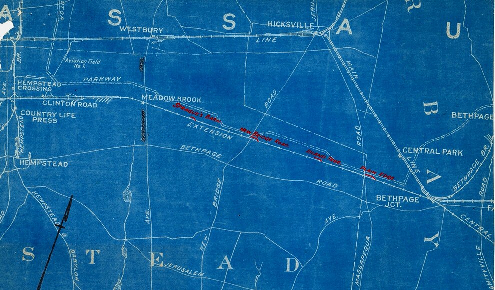
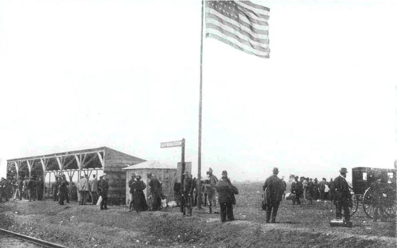
CRR of LI STATION STOPS -
CENTRAL EXTENSION
CRR of LI Station Stop Locations - Library of Congress April 1873
1. Garden City - Cathedral Ave Station built:
Oct/1872-April/1873
2. Clinton Rd, Garden City - Built: _?, listed in service per
CR4 (car record book) 3/01/1913
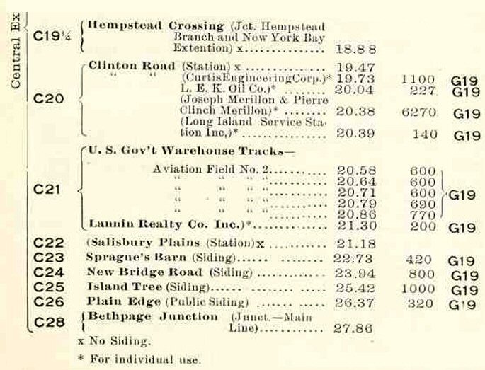
3. Camp Black - 2 ˝ miles east of Garden City. In service:
5/03/1898
Camp Mills - Renamed "Camp Mills"
during WW1 June, 1917
Mitchel Field -
7/16/1918
4. Meadowbrook 2 - Opened further west of original Meadowbrook
1 after 1924 at east end of the Mitchel Field station platform
5. Meadowbrook 1 - 1st station timetable 5/1873. Closed:
6/1917. Later Salisbury Plains after Meadowbrook 2 opened further west
Salisbury Station - NW corner Merrick
Ave. crossing. Wooden shelter shed in service: 6/1917. Prior site of
Meadowbrook 1 station
6. Sprague’s Barn - Manure siding between Meadowbrook 1 and
New Bridge Rd. stations (22.73 miles from LI City.) In service:_? Listed
per CR4 effective: 3/01/1913
7. New Bridge Rd - 1874 Manure siding where New Bridge Road
crossed the Central Ext. (24.12 miles from LI City.) In service:_? Listed
as active per CR4s, eff: 3/01/1913 Out of service: _?
8. Island Trees - Station stop timetable 5/1873. Discontinued
Station stop: 5/01/1876. Manure siding CR4s as “Island Tree” effective
3/01/1913, 9/01/1919, 7/01/1924. Out of service:_?
9. Plain Edge - 1873 Discontinued as station stop_? Location
of manure siding last used in 1939
10. Central Park - Station on 1873 map at Stewart Ave
1924 CR4 Central Extension - Archive: Dave Keller
Central Extension manure sidings blueprint c.1920
Sprague’s Barn - Manure siding between Meadowbrook 1 and New Bridge Rd.
stations
New Bridge Rd - 1874 Manure siding where New Bridge Road crossed the
Central Ext.
Island Trees - Manure siding CR4s as “Island Tree” effective 3/01/1913
Plain Edge - 1873 Discontinued as station stop_? Location of manure siding
last used in 1939
Archive: Art Huneke Research: Dave Keller
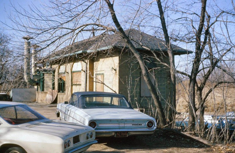
CLINTON RD.
BUILT: _? LISTED IN SVC. AS OF 3/01/1913 C.R.4 (CAR RECORD
BOOK). USED AS TICKET OFFICE FOR CAMP MILLS IN WW I.
AGENCY CLOSED: BY 01/01/1924. STATION CLOSED: 05/15/53. DISCONTINUED AS
STATION STOP. BECAME FIRE STATION No.3. Research: Dave Keller
MP41 #s 1100-1101 as Mitchel Field shuttle at Clinton Road Station,
Garden City, view NE - 3/25/1947 ( Hermanns, Keller)
Clinton Rd. Station 12/21/1965
Photo/Archive: Brad Phillips
LIRR S2 #448 eastbound Mitchel Field freight passing Clinton Road Station
1/21/1972
Photo/Archive: Richard Makse
Extra #159 westbound at Clinton Rd., Garden City 2/08/1977 Photo: John
Scala
Archive: Art Huneke
Clinton Road Station, Garden City view W 8/08/1978 (Madden-Keller)
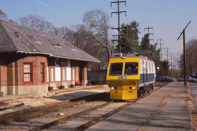
Before there was the TC-82, there was the TC-81 and before that, the
TC-80! Here the TC-80 is proceeding west on the Garden Mitchel Secondary,
going past the former Clinton Road Station, which is now Garden City Fire
Department Station #3. 12/1985
Photo/Archive: Jay Bendersky
Clinton Road Station 3/07/2004
Photo/Archive: Joe Tischner
When the depot became a fire station, a section with bays was added on the
north side of the building to house the fire trucks. Dave Keller
EAST OF CLINTON RD.
A&P (since c.1928) station east of Clinton Road, Garden City on the Central
branch,
view E 12/20/1938 Archive: Dave Keller
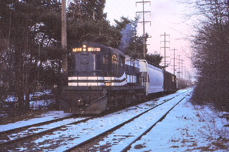
LIRR #223 with short hood forward westbound on the Garden-Mitchel
Secondary
1/1985 Photo/Archive: Jay Bendersky
On a cold late-afternoon in January, 1985, the RF-48 heads
back west after finishing its work on the Garden-Mitchel Secondary. Just
about to flag the busy crossing at Clinton Road in Garden City, it will be
a slow ride home with the eastbound commission hour already under way.
Jay Bendersky
ROW east of Clinton Road, Garden City
View E 9/08/78 (Madden-Keller)
The Mineola-Garden City Freight House/Yard was moved east on the Central
Branch and the switch at NASSAU (formally "MT") was removed. Info: Art
Huneke
The RF-48 is about to get ready to shove its train across Stewart Avenue in
East Garden City. The cars were headed to Global-Sysco Frozen Foods, who was
the busiest receiver of cars on the Garden-Mitchel Secondary at the time.
1/1985 Photo/Archive: Jay Bendersky
The RF-68, with the 164, crosses Stewart Avenue in E. Garden City with an
empty car from Global Sysco. By the end of the decade, regular freight would
be all but gone on the Garden-Mitchel Secondary. 6/1982
Photo/Archive: Jay Bendersky
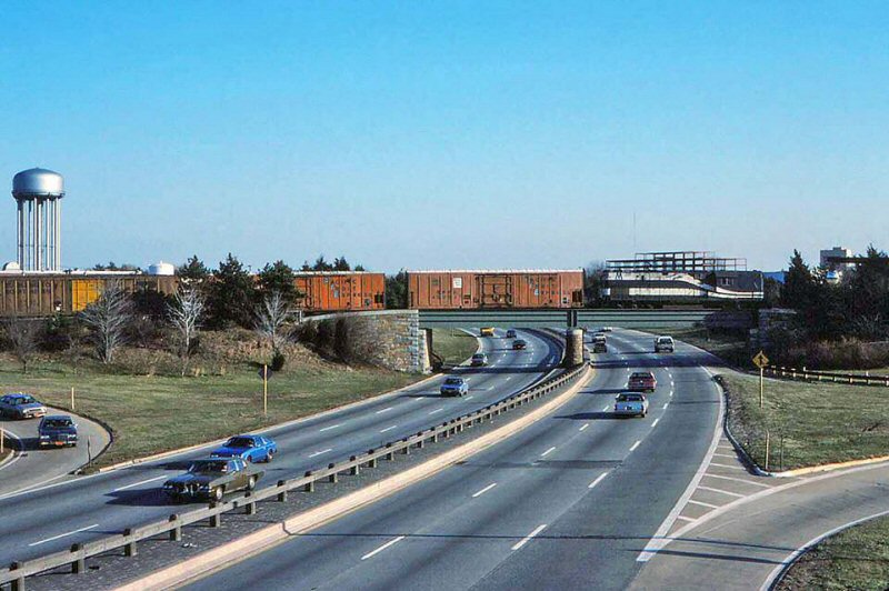
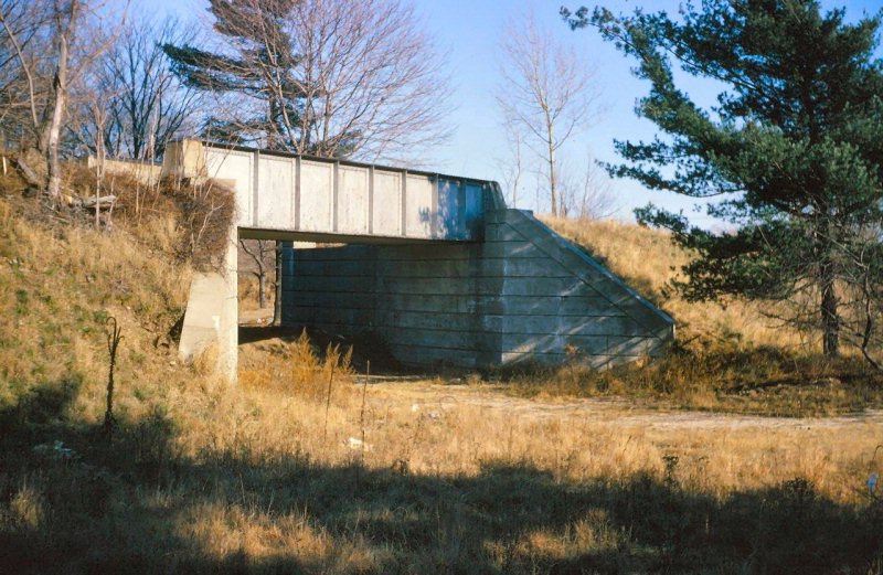
The RF-48 switches Global Sysco on the Garden Mitchel Secondary in June of
1982. In the shadows of the old Roosevelt Raceway, this siding was reached
by a trestle over the Meadowbrook Parkway. Today, the trestle is still
there, with trees growing through the rails. 6/1982. Photo/Archive: Jay
Bendersky
7/1986 Photo/Archive: Jay Bendersky
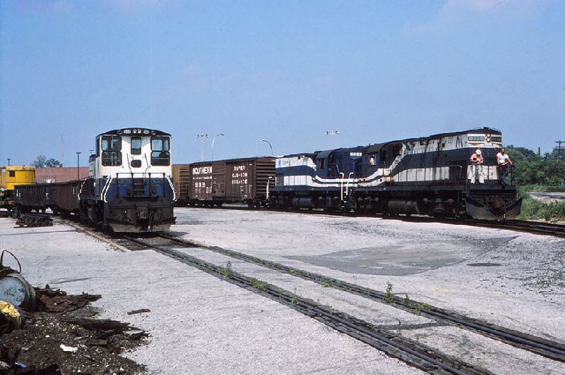
The Mineola-Garden City Freight Yard in an unusually busy
day, even for almost 30 years ago! The RF-7, with 2 L-2's has just crossed
Stewart Avenue re-entering the yard, and Work Extra 152 is in the clear
waiting for the RF-7 to get their work done. Today, the yard's future
remains uncertain with the re-development of the Nassau Coliseum. The RB&BB
Circus Train is the lone tenant of the Garden Mitchel Secondary, just once
every year. Note: LIRR MOW Burro Crane at far left.
LIRR crossing the Meadowbrook Parkway, Garden City - View E 1/1985
Photo/Archive: Jay Bendersky
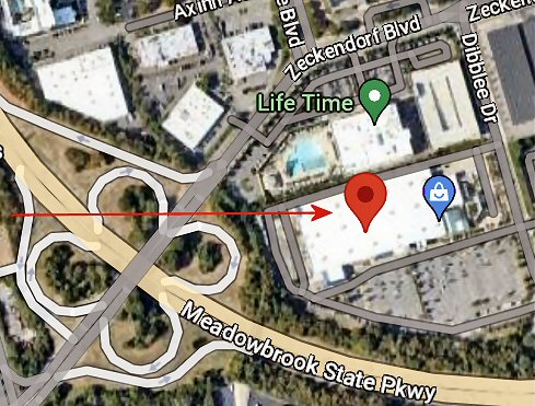
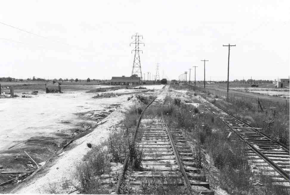
2019 view N of abandoned/razed location
of Global Sysco, LIRR 1986 map location #13
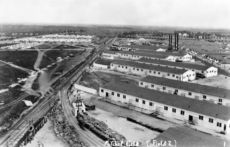
MITCHEL FIELD
ORIGINALLY "AVIATION FIELD NO. 2" ON THE EAST SIDE OF THE
FORMER CAMP MILLS EAST OF GARDEN CITY. CAMP MILLS AND AVIATION FIELD NO. 2
RENAMED "MITCHEL FIELD" 7/16/1918. NAME CHANGE OFFICIALLY APPROVED:
APRIL/1919.) WOODEN SHELTER SHED BUILT: 19_? NO AGENCY. DISCONTINUED AS
STATION STOP: 5/15/53 WITH END OF SHUTTLE PASSENGER SERVICE ON BRANCH.
Research: Dave Keller
Office of Information Services, Head Quarters Continental Air Command, Mitchel Air base, New York
26 October 1955
1. Designation. On July 16, 1918, the installation was named for Major John Purroy Mitchel who had been Killed in an accident in
Louisiana ten days before. Mitchel, who was an early advocate of
American air power, had served as Mayor of New York. The designation "Mitchel Field" was officially approved in April, 1919.
2. Historic Role. For over 150 years the area presently occupied by Mitchel AFB has played an important role in our history. During
the Revolutionary war it was known as the Hempstead Plains and
used as an Army enlistment center. In the War of 1812 and in the Mexican War it was a training center for Infantry units. During
the Civil War, it was the location of Camp Winfield Scott.
In 1898,
in the Spanish-American War, Mitchel's site was known as Camp Black. 2.5
miles east of Garden City. In service: 5/03/1898 for the Spanish-American
War. A wooden shelter was constructed. During World War I, Camp Mills was located here on the grounds
familiar to American Servicemen since the days of our minutemen, trained the Rainbow (42nd) Division, including the famous Fighting
69th Regiment.
Camp Black was opened in 1898 and was 2.5
miles east of Garden City, making that mileage 21.18 from LI City, which
doesn't line up with previous indicated mileages. 21.18 was the
location of the original Meadow Brook station and later, Salisbury
Plains. (Camp Black was renamed "Camp Mills" and the east
side of the camp "Aviation Field No. 2" during WWI. Camp
Mills closed in 1920 and Aviation Field No. 2 was renamed
"Mitchel
Field" 7/16/1918. Photo: Camp Black - 1898
Archive: Richard Eikov
Mitchel Field was originally established in 1917 as
Aviation Field #2 just south of Hazelhurst Field as a training and storage
base. It was named Mitchel Field in July 1918 after former New York City
Mayor John Purroy Mitchel, who was killed while training for the air service
in Louisana.
The Motor Parkway was less than one-half mile north of Mitchel Field. The
"Hempstead Spur Road" to the west of Mitchel Field connecting the Motor
Parkway with Fulton Street was never built.
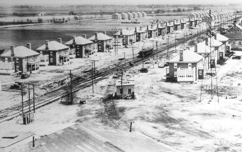
1919 view before the housing construction. Siding in the foreground is the
one recently removed in the c.1930 image below. Archive Art Huneke
Mitchel Field sidings new 1918 removed 1930.
Archive: Art Huneke
View NE of the LIRR Country Life Press-Salisbury
Plains shuttle (ex-Ocean Electric car equipped with third rail shoes)
passing new Mitchel-Field base housing. Trackmen are removing the switch to
one of the 5 former (1918) warehouse sidings in the center of the image.
This image shows the warehouses being replaced with the new housing. One
warehouse, siding and switch off the main still remain in the upper right
portion of this c.1930 image. Research/Archive: Dave Keller
Mitchel Field area - 1923 Belcher Hyde Map
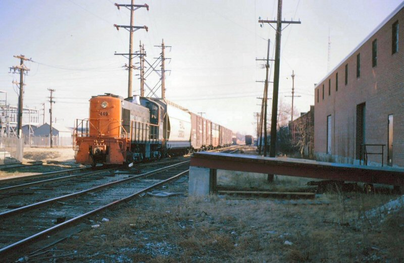
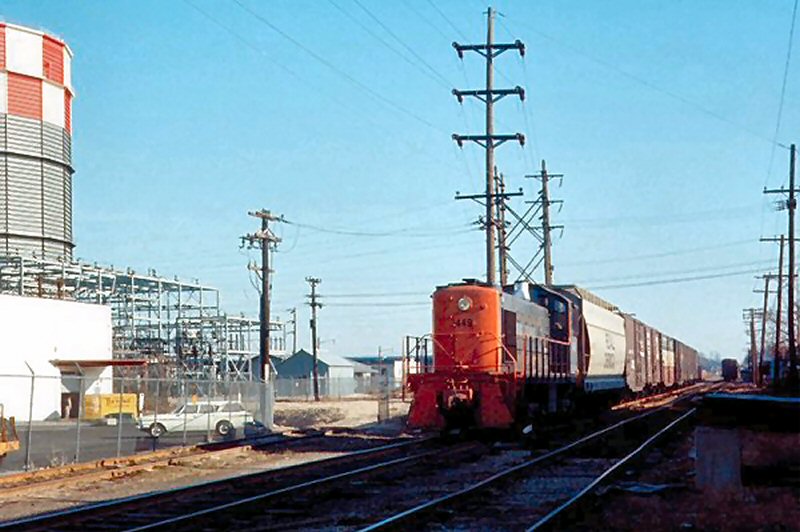
LIRR #449 approaching Mitchel Field 12/21/1965 Photo/Archive: Brad Phillips
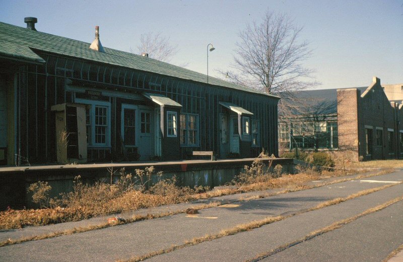
Mitchel Field Passenger Office 12/21/1965
Photo/Archive: Brad Phillips
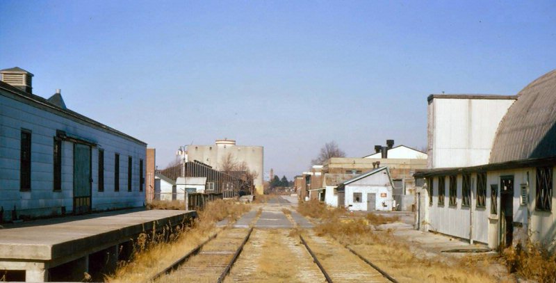
Mitchel Field rail facilities - View E 12/21/1965
Photo/Archive: Brad Phillips
Mitchel Field Passenger Station platform
View W 12/21/1965 Photo/Archive: Brad
Phillips
ROW west of Zeckendorf Blvd - View E 9/08/78 (Madden-Keller)
ROW at Quentin Roosevelt Blvd, East Garden City View E 9/08/1978
(Madden-Keller)
Garden City secondary tracks and ROW
View W. Short St., Garden City 1/1988 Photo/Archive: Jay
Bendersky
By 1988, freight on the Garden-Mitchel Secondary was no
longer daily, and was switched as-needed. The RF-7 has just finished picking
up it's refrigerator cars at Global-Sysco, on the other side of the
Meadowbrook Parkway. There are no other empties to add on to the train, so
it will now be heading back to Yard A, with the C-63 on the east end.
Jay Bendersky
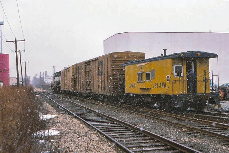
A westbound road freight rumbles through Newsday (since 6/1949) crossover on the Central
Extension. The track through the gate on the left leads to the Newsday
plant. About 100' to the rear was the site of the former Newsday platform,
used by the Mitchel Field shuttle until 1953. On the right is the one box
car spot for Mercury Millwork. An absolutely fascinating piece of the LIRR
that saw freights, race trains, circus trains and MU's and trolleys during
its heyday. Richard Makse
Garden City secondary tracks and ROW View W Quentin Roosevelt Blvd.
Garden City 6/1999 (Lynch-Keller)
Emery Map Central Branch MP19-20
Clinton Rd 5/1958 Archive: Dave Keller
Garden City secondary tracks in street View E Quentin Roosevelt Blvd. Garden City 6/1999 (Lynch-Keller)
ROW Selfridge Ave. Central Branch View E 9/08/78 (Madden-Keller)
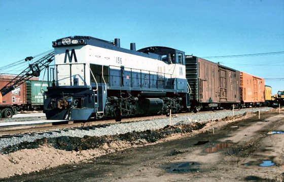
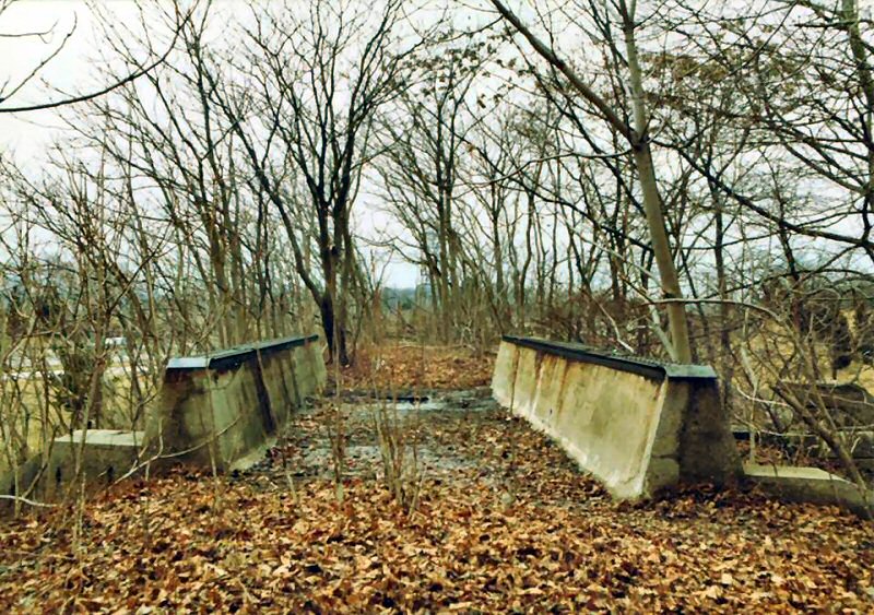
MP15ac #156 Train RF-68 westbound over Meadowbrook Parkway 8/25/77
(Madden-Keller)
ROW at Meadowbrook Parkway View E 8/08/78 (Madden-Keller)
LIRR #156 Central Branch c.1980
Photo/Archive: William Madden
Electric Railroader's Association fantrip in October of 1985. LIRR #605 is
in the lead west as it crosses the Meadowbrook Parkway on the Garden-Mitchel
Secondary. Today, the trestle is still there - with trees going through it,
with that segment of the Secondary being long out of service. Photo/Archive:
Jay Bendersky
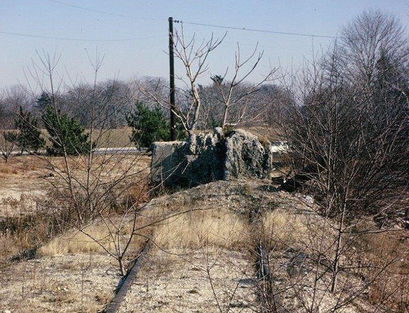
Former CRR of LI bridge - Garden City
View W 3/25/2016
Photo/Archive: Joshua
Soren
MEADOWBROOK
1ST DEPOT LISTED IN TT OF 05/1873.
LOCATED BETWEEN PRESENT MERRICK AVE. AND THE MEADOWBROOK PARKWAY.
DISCONTINUED AS A
STATION STOP PER TT OF 05/01/1876. LATER LISTED IN SVC. PER C.R.4 EFF:
03/01/1913. CLOSED: 6/1917. BECAME SITE OF SALISBURY PLAINS STATION AFTER
2ND MEADOWBROOK STATION OPENED FURTHER WEST. Research: Dave Keller
H10s #107 Railfan Extra Meadowbrook Station Westbury 10/26/52 (Votava-Keller)
MU Train for Roosevelt Raceway at Meadowbrook Station view W 1953
(Edwards-Keller)
MU Train for Roosevelt Raceway on layup track Meadowbrook 1953
(Edwards-Keller)
Meadowbrook Station Roosevelt Raceway Sign 10/21/1961 (Faxon-Keller)
Former site of Roosevelt Raceway, Meadowbrook Station - Central Branch
View W 4/19/73 (Madden-Keller)
Former site of Roosevelt Raceway, Meadowbrook Station - Central Branch
View W 9/08/78 (Madden-Keller)
View east from west of Carman Ave, behind
Meadowbrook Hospital. Construction materials for the building of Levittown
were delivered here at this siding known from 1948 C.R.4 as "C 24 Newbridge". Photo:
Vincent F. Seyfried 1952
C.R.4 October 1, 1948 Station "C 24 Newbridge" apparently siding
installed for delivery of construction materials for Levittown
Employee Timetable (ETT) No.2, June 21, 1942 showing
track still ran 7.5 miles to Plain Edge and Pass Service to Salisbury
(Plains)
Henry Wilhelm visited the area in 1942, 1948, and
later. In 1945 the track ended behind Meadowbrook Hospital. In 1948, he
noted the sidings for the Levittown constructions materials.
Employee Timetable No.3, September 20, 1942.
Branch cut back to Meadowbrook Hospital, Service cut back to Mitchell
Field
Central Branch trestle east of Meadowbrook Parkway, East Meadow 1955
(Schneider-Keller)
Right of way crossing Wantagh Parkway at grade with provision for tracks
to be reinstalled should service be resumed - near Levittown, NY - 1955
(Rolf Schneider photo, Dave Keller archive)
Central Branch stone overpass west of Bethpage State Parkway 1955 (Schneider-Keller)
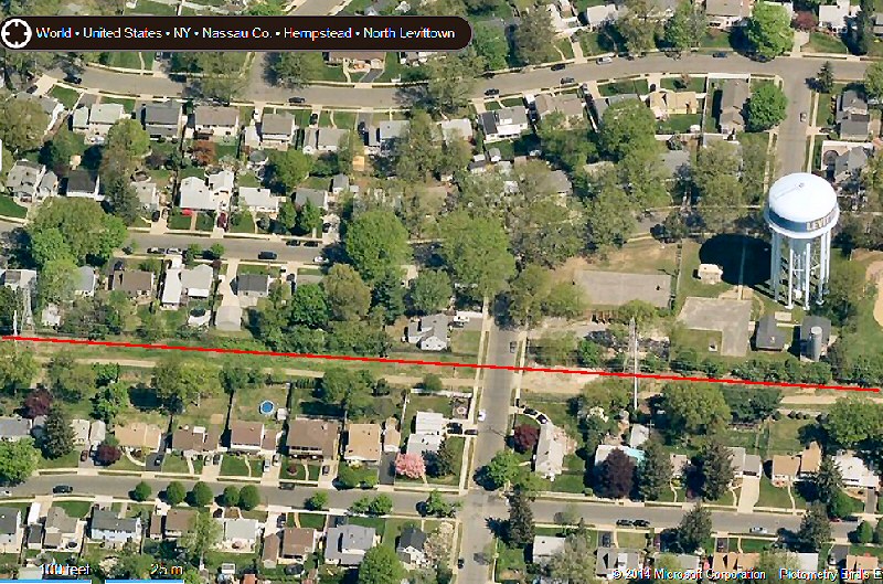
Ex-LIRR ROW Jerusalem Ave. to Hicksville
Rd., Ex-LIRR ROW at Hilltop Rd., Levittown
Bing Maps
Meadowbrook Station platform view W 12/21/1965 Photo/Archive: Brad Phillips
SALISBURY PLAINS
AT NW QUADRANT OF MERRICK AVE. CROSSING.
WOODEN SHELTER SHED IN SVC: 06/1917. FORMER SITE OF 1ST MEADOWBROOK
STATION. CLINTON ROAD STATION PROVIDED AGENCY DURING WWI. SHELTER
USED TO STORE LUMBER DURING CONSTRUCTION OF 2ND DEPOT. RAZED: 1923 (?)
2ND DEPOT OPENED: 12/10/1923, NO AGENCY INDICATED AS OF 1/01/1924. CLOSED:
c. 1942-43 DUE TO WARTIME SECURITY OF TRAINS PASSING THROUGH MITCHEL FIELD
TO ACCESS THIS STATION STOP. DEPOT BECAME A RESIDENCE IN FEB. 1947 FOR A
SHORT PERIOD OF TIME AND LATER HOUSED A PRIVATE BUSINESS. TRACKS REMOVED:
1956. RAZED: 1985 (per Nassau Co. website).
https://www.nassaucountyny.gov/4246/History-of-Eisenhower-Park
Research: Dave Keller MORE
Salisbury Plains
Ex-Ocean Electric car #15 in
Country Life press-Salisbury Plains shuttle service eastbound past the new
Salisbury Plains station under construction (View NW) - 1923
Archive: Dave Keller
View looking west toward Salisbury Plains
Station in left background. Photo: Vincent F. Seyfried 1952
Archive: Art Huneke
The original grade AND concrete platform were
still in place 8/09/64 in this view looking NW. Right after WWII, a young couple
lived in the building. When photographed, it appears that some
commercial enterprise had occupied it and really messed up the looks of
the building. (Richard Makse photo/Dave Keller archive)
This front view is looking NE on April 1, 1979.
The station was on the north side of the tracks and where the photographer
stood to take the photo would have been about where the tracks once were.
The platform was at the base of the doors and bay window brickwork, with
the parking lot in this image at a lower elevation than when tracks ran
here. (William Madden photo / Dave Keller archive)
Salisbury Plains Station 12/21/1965 Photo/Archive: Brad Phillips
Salisbury Plains overpass - Road was never built 12/21/1965 Photo/Archive: Brad Phillips
West of Meadow Parkway end of track View E 12/21/1965 - Photo/Archive: Brad Phillips
This photo is the farthest east end
of the Central Branch trackage remaining as of 12/21/1965.
Note the Meadowbrook Parkway is in the distance. Info: Brad Phillips
NEW
BRIDGE ROAD
STATION FIRST LISTED IN TT OF 4/1874 EAST OF CENTRAL PARK STATION (AT
STEWART AVE.) NO INDICATION OF DEPOT BLDG. CONSTRUCTED. LAST LISTED IN TT
OF 10/1876. ETT #13 EFF: 1879, INDICATES EASTBOUND TRAIN #19 WILL MAKE
STATION STOP ALTHOUGH STATION IS NO LONGER INDICATED IN TIMETABLE LISTING
OF STOPS. (Vincent Seyfried and Art Huneke data)
MANURE SIDING WHERE NEW BRIDGE ROAD CROSSED THE CENTRAL EXT. (24.12 MILES
FROM LI CITY.) IN SVC.: _? IS LISTED AS ACTIVE PER C.R.4s EFF: 03/01/1913,
09/01/1919 AND 07/01/1924. OUT OF SVC.: _? Research: Dave
Keller
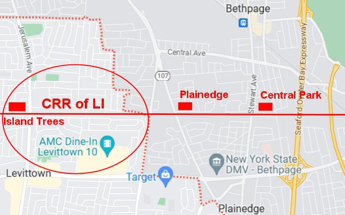
ISLAND TREES
STATION STOP FIRST LISTED IN TT OF 5/1873. NO DEPOT BUILDING ERECTED
LOCATED AT JERUSALEM AVE. IN TODAY’S LEVITTOWN. DISCONTINUED AS STATION
STOP: 5/01/1876. LATER SITE OF MANURE SIDING (25.40 MILES FROM LI CITY).
SIDING LISTED IN C.R.4s AS “ISLAND TREE.” EFF. 3/01/1913, 9/01/1919 AND
7/01/1924. OUT OF SVC: _?
2ND STATION CONSISTING OF A 1,000 FOOT LONG, LOW, CINDER PLATFORM OPENED:
1916 AT HICKSVILLE RD. CROSSING OF CENTRAL EXTENSION AT WHAT IS TODAY’S
LEVITTOWN, FOR MERILLON ESTATES CORP. (REAL ESTATE DEVELOPER). CLOSED:
19_? (Vincent Seyfried and Art Huneke data) Research: Dave Keller
"The name Island Trees first appeared on a 1747 land deed between the
Weeks and the Seaman families and refers to a landmark called ‘the Island
of Trees,’ an ancient grove of pitch pines that grew at the northeast
corner of Hempstead Turnpike and Jerusalem Avenue northwards to about
where Mallard Road is today, until 1948,” said Manton, adding that it was
named so as the surrounding land was part of the open country of the
Hempstead Plains, it appeared as an isle of trees in a sea of grass. “The
name was used for the general area as an informal place-name, until the
area officially became part of Levittown on Jan. 1, 1948.” Long
Island Weekly,
Approximate area of Island Trees - CRR of LI 1873 station
locations
PLAINEDGE
CENTRAL R.R. DEPOT APPEARS ON MAP OF PLAINEDGE AT
MASSAPEQUA RD. (LATER HICKSVILLE RD. RT. 107). NO INFORMATION REGARDING
PASSENGER SVC.
DISCONTINUED AS STATION STOP _? BECAME END OF TRACK 4.8 MILES EAST
OF SALISBURY PLAINS STATION (NEAR HICKSVILLE RD. RT. 107) PER ETT #9, EFF.
6/19/1938. WAS LOCATION OF MANURE SIDING. LAST USED IN 1939. TRACKS STILL
IN PLACE PER ETT #2 EFF: 06/21/1942 ALTHOUGH SEVERED BY CONSTRUCTION
OF
WANTAGH STATE PARKWAY. NO LONGER LISTED ON ETT #3, EFF. 09/20/1942. Research: Dave Keller
Plainedge Depot foundation - View W - 12/21/1965 - Photo/Archive: Brad
Phillips
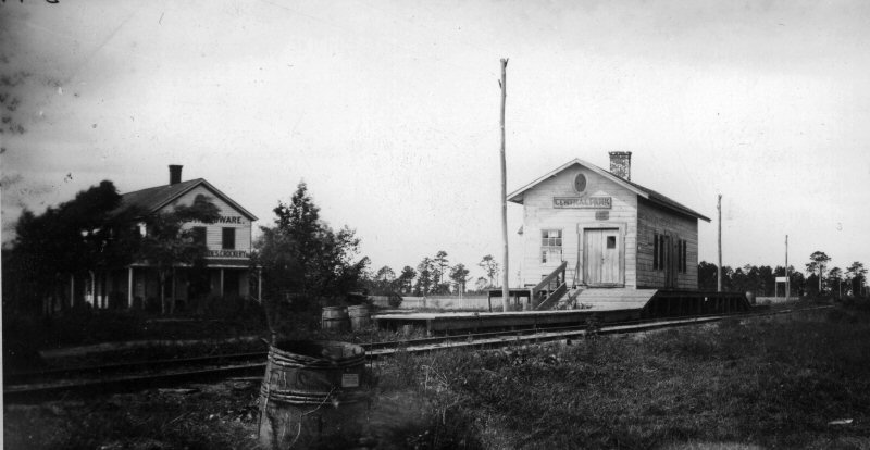
CENTRAL PARK
STATION FIRST LISTED ON TT OF 05/1873. LOCATED AT EAST
SIDE OF STEWART AVE. IN TODAY’S PLAINEDGE. ľ MILE GEOGRAPHICALLY SOUTH OF
LIRR’S JERUSALEM/CENTRAL PARK STATION. NO DEPOT AS OF 2/1874. THE AGENT
USED A ROOM IN HIS HOUSE AS A PUBLIC WAITING ROOM. LAST LISTED AS A STOP
IN TT OF 10/1876. ETT #13 EFF: 1879 INDICATES EASTBOUND TRAIN #19 WILL
MAKE STATION STOP ALTHOUGH STATION IS NO LONGER INDICATED IN THE
TIMETABLE’S LISTING OF STOPS. (Combined data Per Art Huneke and Vincent F.
Seyfried) Research: Dave KellerI
CRR of LI - Central Park Depot 1873 map
A side track was installed for freight cars in January, 1874, and a swing
pole for
farmers to load hay and straw onto the freight platform. Info: Vincent
Seyfried
CRR of LI - Central Park Depot view SW 1879
Photo: George Brainerd Archive: Dave Keller
In 1925 the disused Central Extension between Farmingdale
and Babylon was extensively overhauled for the use of through trains to
Babylon and points east, this change being necessitated by the
electrification of the Montauk Division. At the same time, however, this
rehabilitated stretch was linked up to the Main Line at Farmingdale
(Bethpage Junction) and the plains section cut back to Stewart Avenue,
Plainedge (above). Once this track connection was broken, the remainder of
the Central Extension on the plains was doomed. Info: Vincent
Seyfried
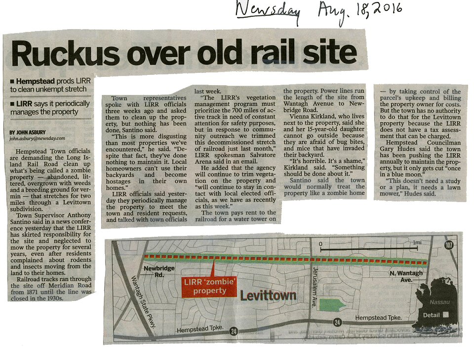
"Ruckus over old rail site"
8/18/2016 (NEWSDAY- Dave Morrison)
BETHPAGE
JUNCTION
CENTRAL RAILROAD OF L.I. DEPOT FIRST APPEARS ON
TIMETABLE OF 6/1873. APPEARS ON 1876 FREIGHT REPORT. LOCATED AT
WEST SIDE OF JUNCTION. USED BY BOTH CRR AND LIRR TRAINS TO AFFORD
CONNECTIONS TO RIDERS (Per Art Huneke). ABANDONED: 10/1/1877 (Per Vincent
Seyfried). STILL APPEARS ON 1897 TIMETABLES WITH MINIMAL SERVICE. (??)
CENTRAL EXTENSION TRACKS SEVERED FROM JUNCTION WITH REFURBISHING OF THE
LIRR’S CENTRAL BRANCH IN 1925. Research: Dave Keller
GENERAL ORDER: EFFECTIVE 1921: BETHPAGE
AND CREEDMOOR BRANCHES AND CENTRAL EXTENSION “HC” TO BETHPAGE JCT.
WILL BE CONSIDERED SIDINGS. The Bethpage branch was the short spur off the Central extension
east of Bethpage Jct. accessing the brick works in Bethpage (see map top
of page). Info: Dave Keller
Maps of the Central Branch Archive: Dave Keller
Emery Map Central Branch MP15-16 1943
Emery Map Central Branch MP16-17
Stewart Manor 6/1958
Emery Map Central Branch MP17-18
Nassau Blvd. 1/1958
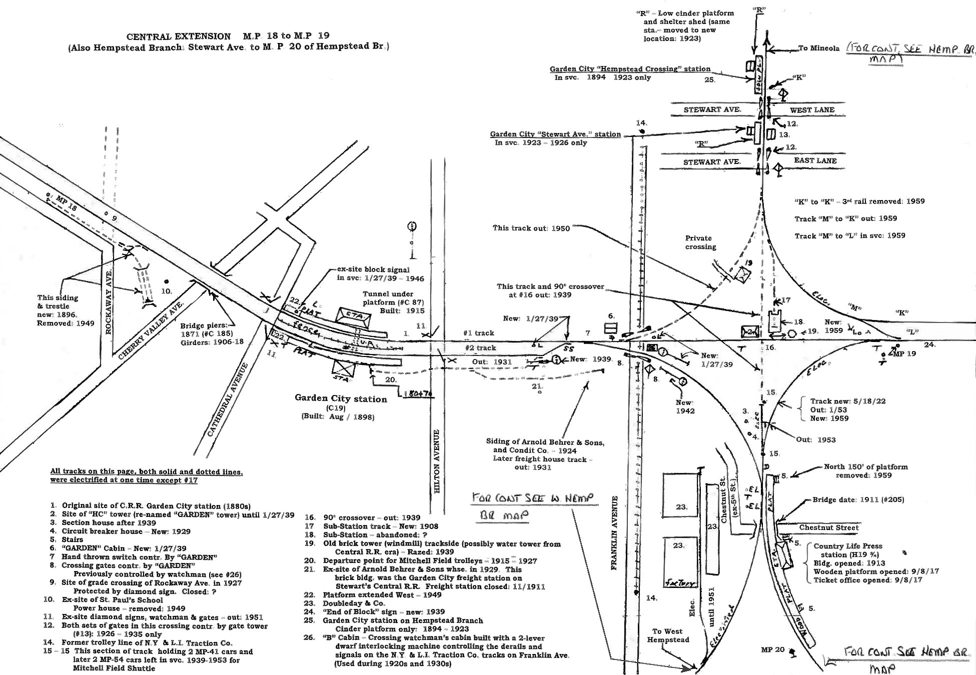
Emery map 5/1958 Central Branch MP18-MP19 west/east
Also, Hempstead Branch to Garden City MP20 north/south
Emery Map Central Branch MP19-20 Clinton Rd 5/1958
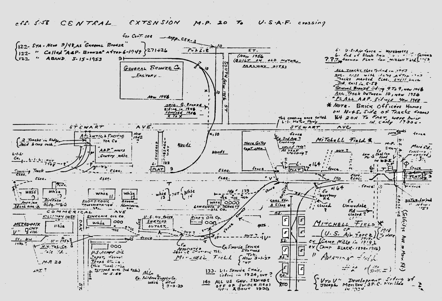
Emery Map Central Branch MP20 to USAF Crossing 5/1958
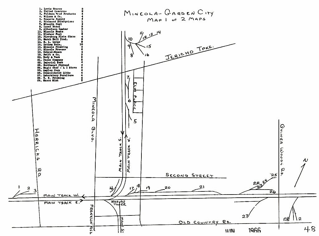
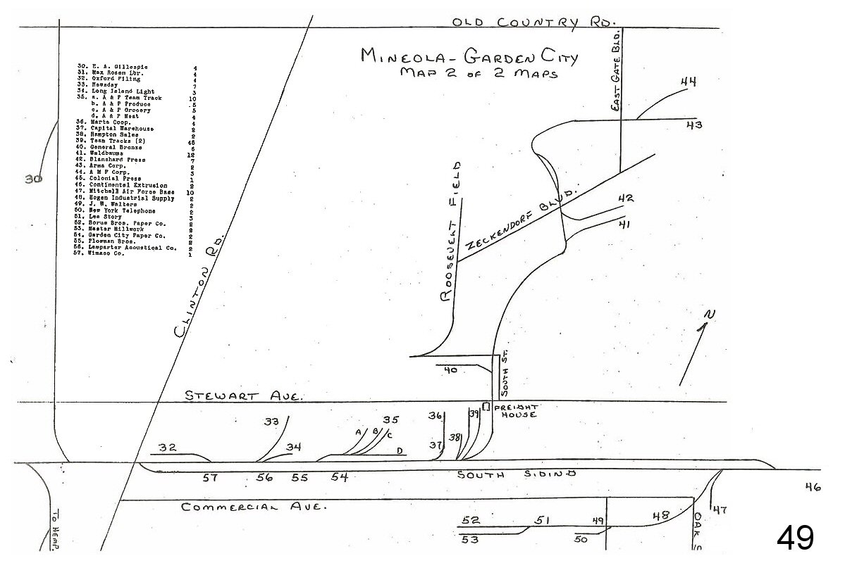
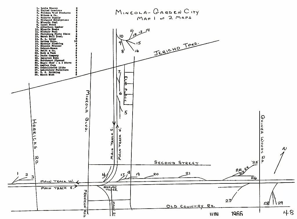
Mineola - Garden City Secondary 1966 LIRR Track Map p.48
Garden City LIRR Profile Map
Mineola - Garden City Secondary 1966 LIRR Track Map p.49
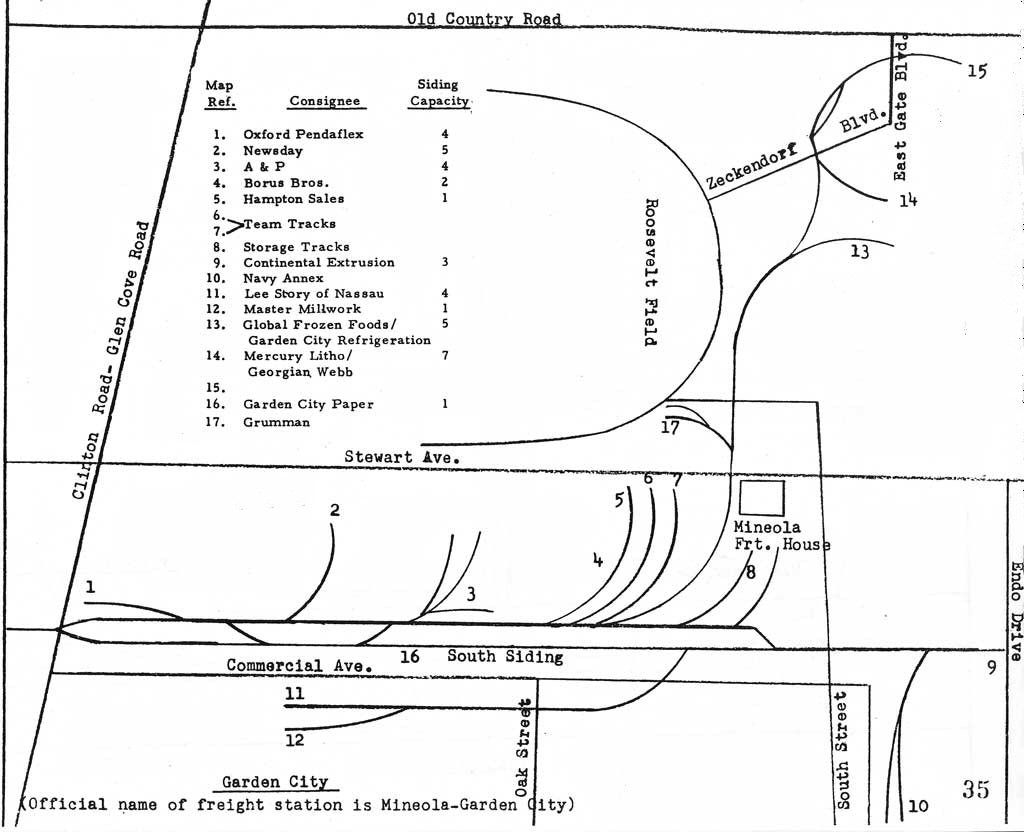
LIRR Track Map Garden City Secondary 1978 page 35
Archive: Jeff Erlitz
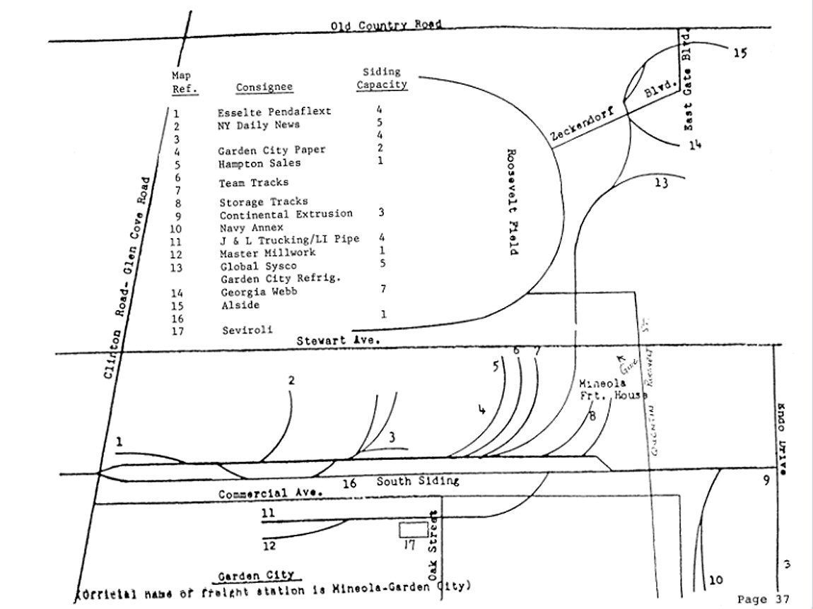
LIRR Track Map Garden City Secondary 1986 page 37
Archive: Jeff Erlitz
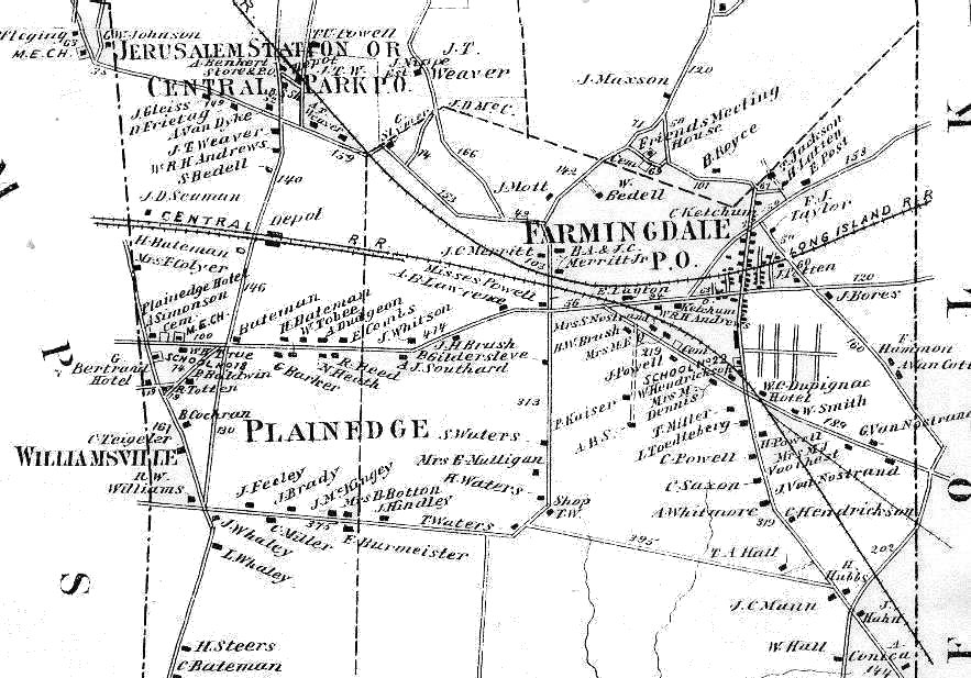
North Nassau Closeup - Central Railroad of Long Island Extension 1873 -
Farmingdale Area Archive: Steve Lynch
LIRR Central Branch
Info: Roger Ramsdale/LIST Semaphore
LIRR 1966 Freight Map
LIRR 1986 Freight Map
Became*
30 E.A. Gillespie
31 Max Rosen Lumber
32 Oxford Filing
1 Oxford Pendaflex 1969
Esselte in 1976... FedEx
33 Newsday
2 Daily News
34 LILCO
LIPA/Nat Grid
35 A&P
3 A&P
Stewart Plaza parking lot 1990
36 Marta Coop.
37 Capital Warehouse
4 Borus Bros.
Garden City Paper...Mattress shop and a small Professional building
38 Hampton Sales
5 Hampton Sales
39 Team Tracks
6,7 Team Tracks
40 General Bronze
17 Grumman
HQ of Computer Associates... Retail Stores...BJ's
and LA Fitness
41 Waldbaums
13 Global Sysco/Garden City Refrig
Lowes
42 Blanchard Press
14 Mercury Litho/Georgia Webb
Fortunoff's Outdoor store...Life Time Fitness
43 Arma Corp
Gallard & Schlesinger...Budenheim in 2005... AAR
Aircraft Services
44 AMF Corp
AVIS...Cendant...Retail Center...Gallery At
Westbury
45 Colonial Press
46 Continental Extrusion
9 Continental Extrusion
Foremost Cold Storage...Printing facility for
Herald/Prime Time
47 Mitchel Air Force Base
10 Navy Annex
Abandoned
48 Hogan Industrial Supply
49 J.W. Walthers
50 NY Telephone
51 Lee Story
11 Lee Story
Serivoli Foods
52 Borus Bros. Paper Co.
J&L Trucking/LI Pipe
53 Master Millwork
12 Master Millwork
54 Garden City Paper Co.
16 Garden City Paper
55 Plowman Bros.
56 Lamparter Acoustical Co.
57 Wimaco Co.
Note *: As of 2016
The NY&A officially took over Long
Island Rail Road's freight operations on May 11, 1997
MTA
Headquarters Press Release February 5, 1997
Freight
Agreement Addresses Community Concerns
The Metropolitan Transportation Authority today announced that the MTA Long Island Rail Road (LIRR) and New York Atlantic Railway
(NYAR) have agreed to a moratorium on the rail movement of municipal solid waste, including ash, and the use of the intermodal facility in Garden City until December 31, 1999. The agreement comes at the request of Governor George E.
Pataki, who had expressed his concern to the MTA over issues raised by local officials.

%20(1).jpg)
%20(2).jpg)
.jpg)
.jpg)
.jpg)
.jpg)

%20-%2007-23-1918%20(LIRR%20Valuation-Keller).jpg)

.jpg)
.jpg)


.JPG)
.JPG)
.JPG)
 The
inset sign tells riders to take the trolley on the other side of the
station, where the layup track was originally located:
The
inset sign tells riders to take the trolley on the other side of the
station, where the layup track was originally located:.jpg)
%20(Zoom).jpg)
.jpg)
.jpg)
.jpg)
.jpg)
.jpg)
.jpg)
%20-%201949%20(Edwards-Keller).jpg)
.jpg)
.jpg)
.jpg)
%20-%2011-21-93%20(Madden-Keller).jpg)


.jpg)
.JPG)
.jpg)
.jpg)
.jpg)

%20E%20of%20Gdn%20City%20-%201955%20(Schneider-Keller).jpg)
.jpg)
%20-%2003-19-73%20(Madden-Keller).jpg)
%20-%2003-19-73%20(Madden-Keller).jpg)
%20-%2009-08-78%20(Madden-Keller).jpg)
%20-%2009-08-78(Madden-Keller).jpg)
.jpg)
%201973%20(Art%20Huneke%20archive).jpg)
%20-%2009-08-78%20(Madden-Keller).jpg)
%20-%2009-08-78%20(Madden-Keller).jpg)
%20-%2009-08-78%20(Madden-Keller).jpg)

,%20view%20NE%20-%203-25-47%20(Ed%20Hermanns%20photo;%20%20Dave%20Keller%20archive).jpg)
%20-%2009-08-78%20(Madden-Keller).jpg)
.jpg)
%20-%2009-08-78%20(Madden-Keller).jpg)


%20-%2009-08-78%20(Madden-Keller).jpg)
%20-%2009-08-78%20(Madden-Keller).jpg)
.jpg)
.jpg)
%20-%2009-08-78%20(Madden-Keller).jpg)
.jpg)
.jpg)
.jpg)
.jpg)
.jpg)
.jpg)
%20-%2004-19-73%20(Madden-Keller).jpg)
%20-%2009-08-78%20(Madden-Keller).jpg)
.jpg)
.jpg)
.jpg)


.jpg)
.jpg)
%20-%2004-01-79%20(Madden-Keller).jpg)


%20-%2011-21-93%20(Madden-Keller).jpg)
%20-%20Copy.jpg)
.jpg)
.jpg)
.jpg)