|
Robert Emery Whitestone Branch Historical Dates |
||
|
Built, Flushing (Bridge Street) to College Point, by
the Flushing & North Side R.R.: 1868 |
||
|
Robert Emery
Maps of the Whitestone Branch - Pre-February 19, 1932 |
||
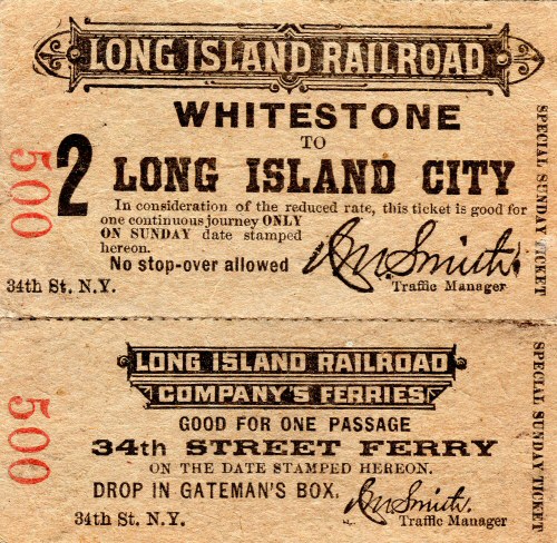
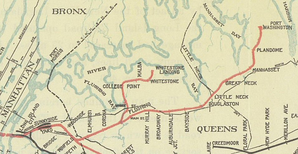
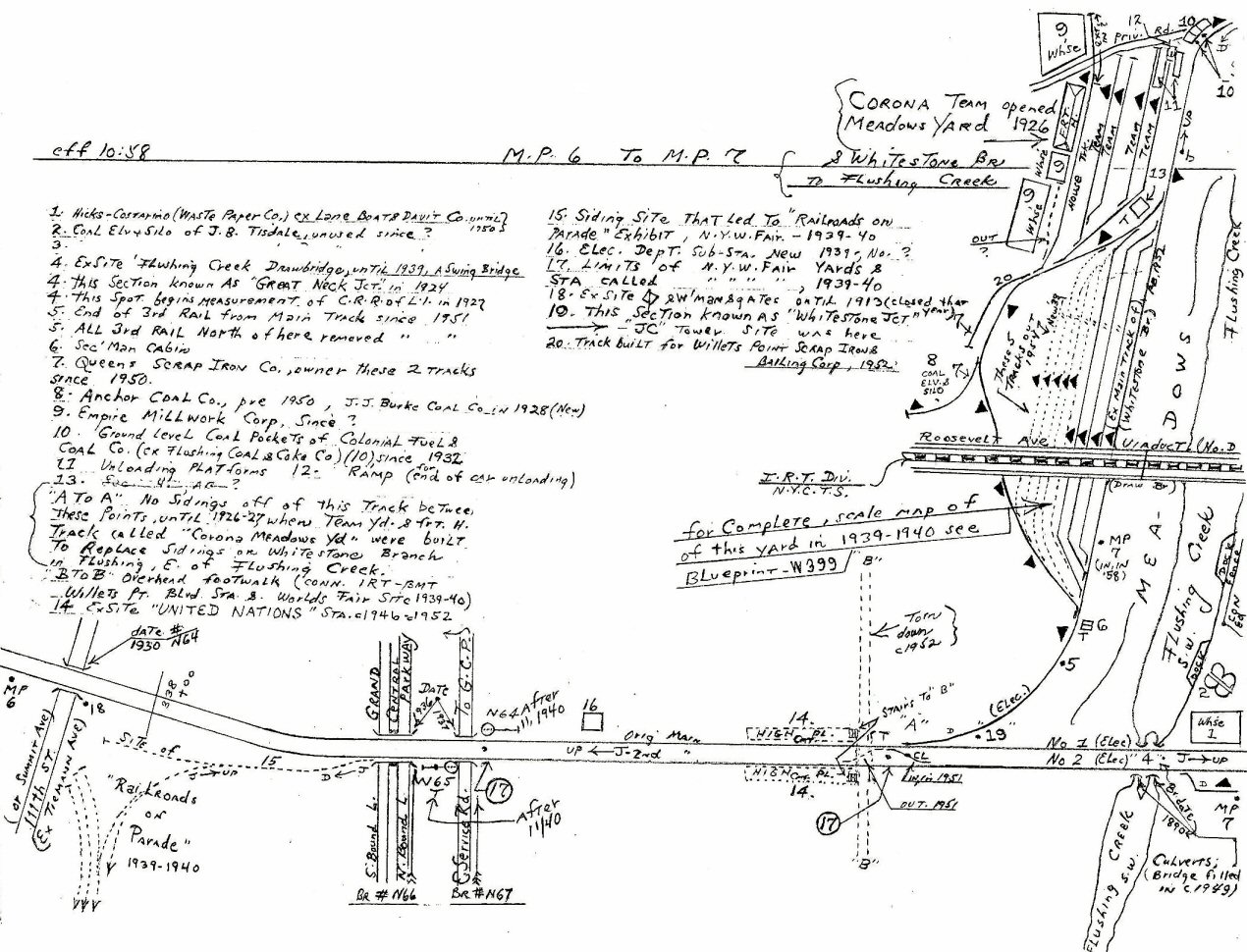 Whitestone MP6-MP7 |
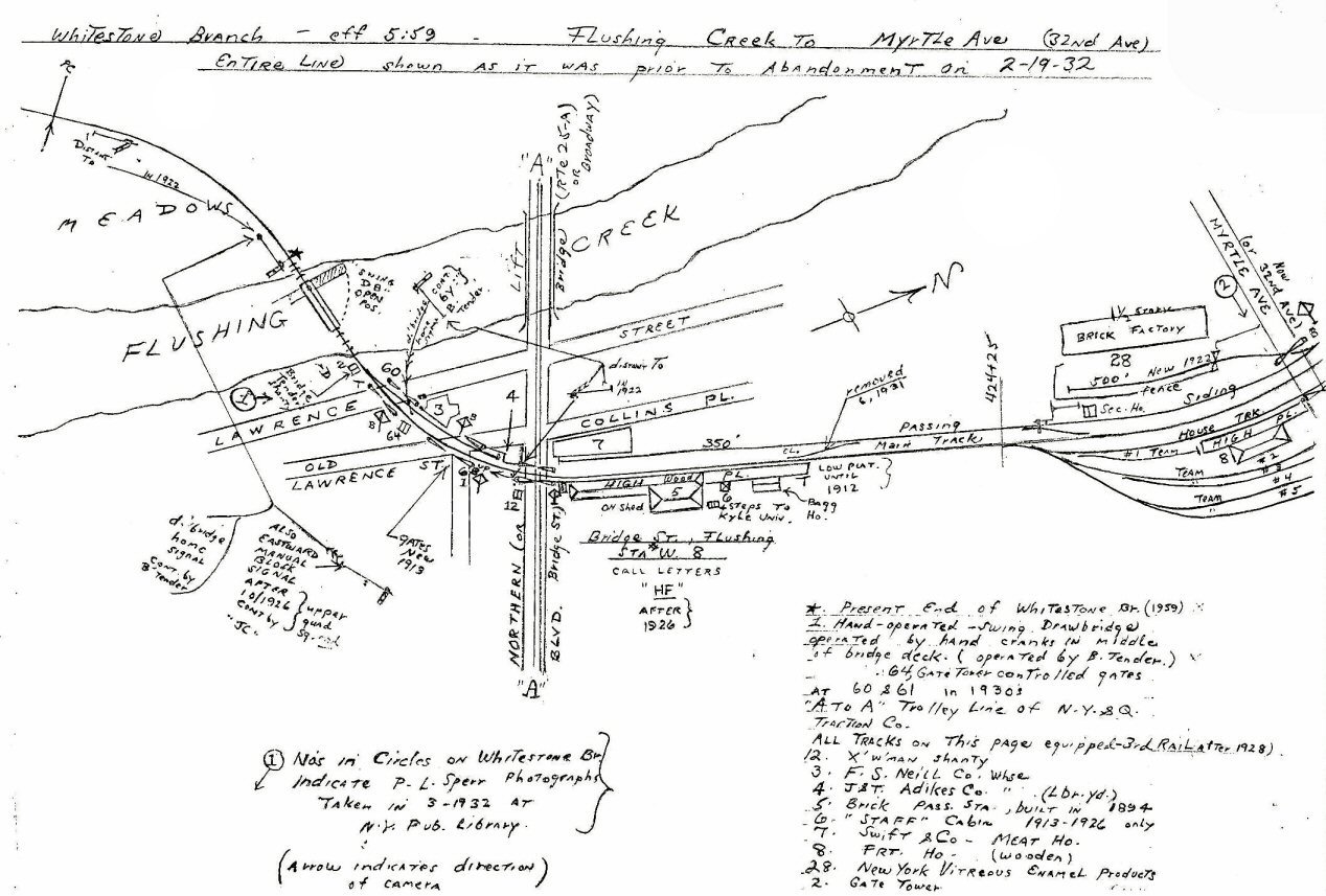 Flushing Creek to Myrtle Ave Bridge Street Station, Flushing |
|
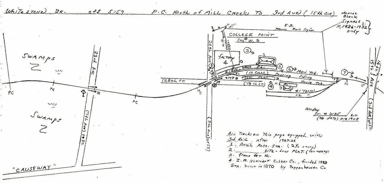 Mill Creek to 3rd Ave - College Point Station |
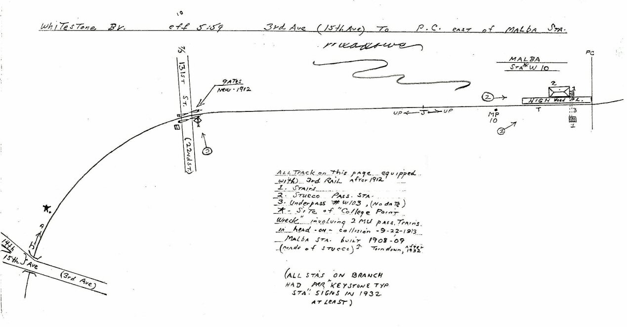 3rd Ave to Malba Station |
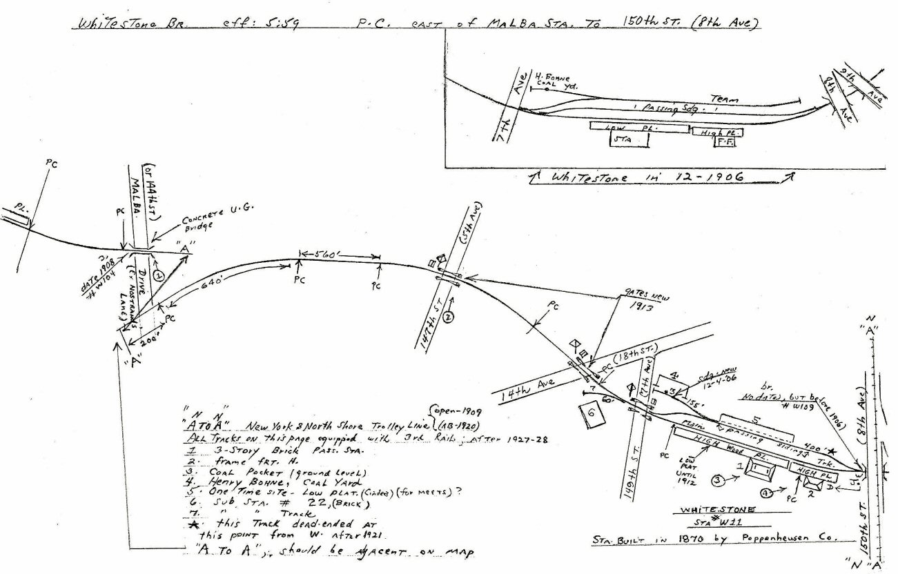 Malba Station to 150th Street Whitestone Station |
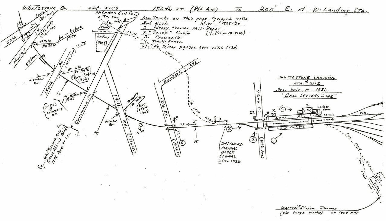 150th Street to Whitestone Landing Station |
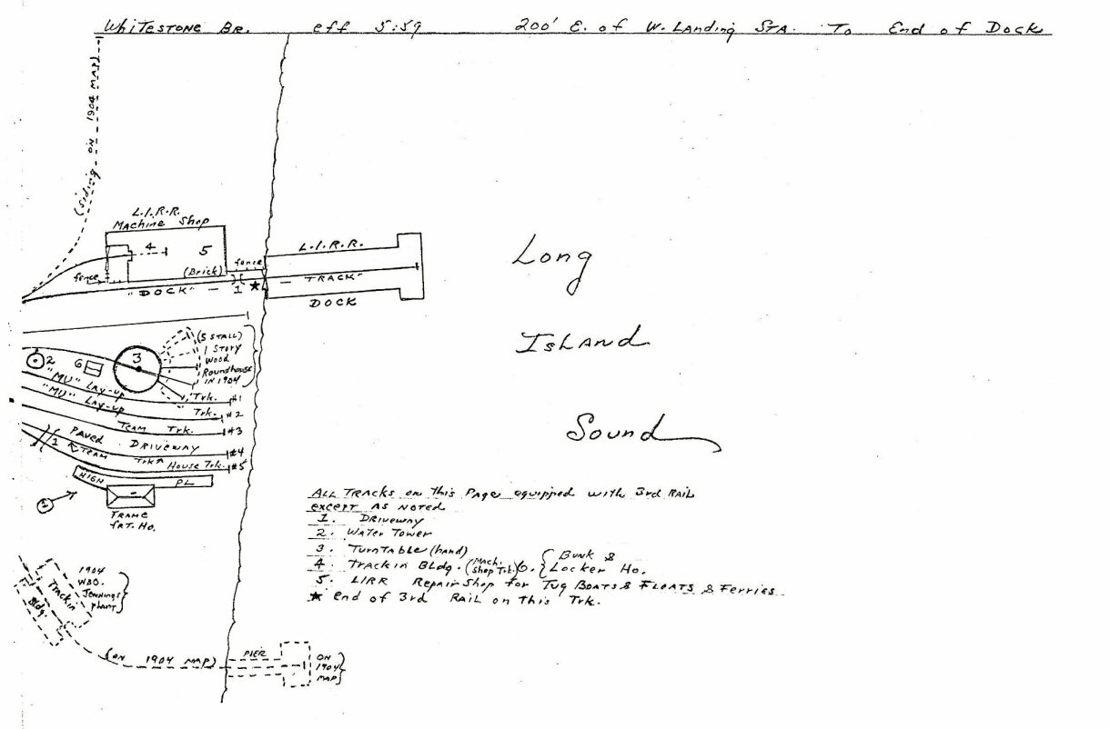 Whitestone Landing Station to end of dock |
||||
| WHITESTONE BRANCH MILEPOSTS | |||||
|
Mileage from LI City based on an old CR4 book and mileage from "WJ" tower ("WIN") from my 1929 ETT. The mileage is indicated from "WJ" tower ("WIN") because the Whitestone branch was connected to the Port Washington branch (North Side Division) and Port Washington branch mileage was clocked from "WJ" tower where the branch left the Main Line. I've provided a comparison below (these are mileages to the actual station building, not to even numbered mileposts as Emery provided on his other maps): "JC" Tower (Whitestone
Junction) = 2.9 miles from "WJ" tower
("WIN") / 6.73 miles from LI City The mileage indicated from "WJ"
vs. the mileage indicated from LI City is off by about 3/10 mile.
Emery states Whitestone as station W11. That means Whitestone
branch station, 11 miles. Looking at my mileages above from LI
City, the stations were obviously numbered from LI City for
identification purposes, and not "WJ" tower.
Whitestone is roughly correct . . . off by .27 miles . . . there's my
indicated 3/10 mile difference. Research: Dave Keller |
|||||
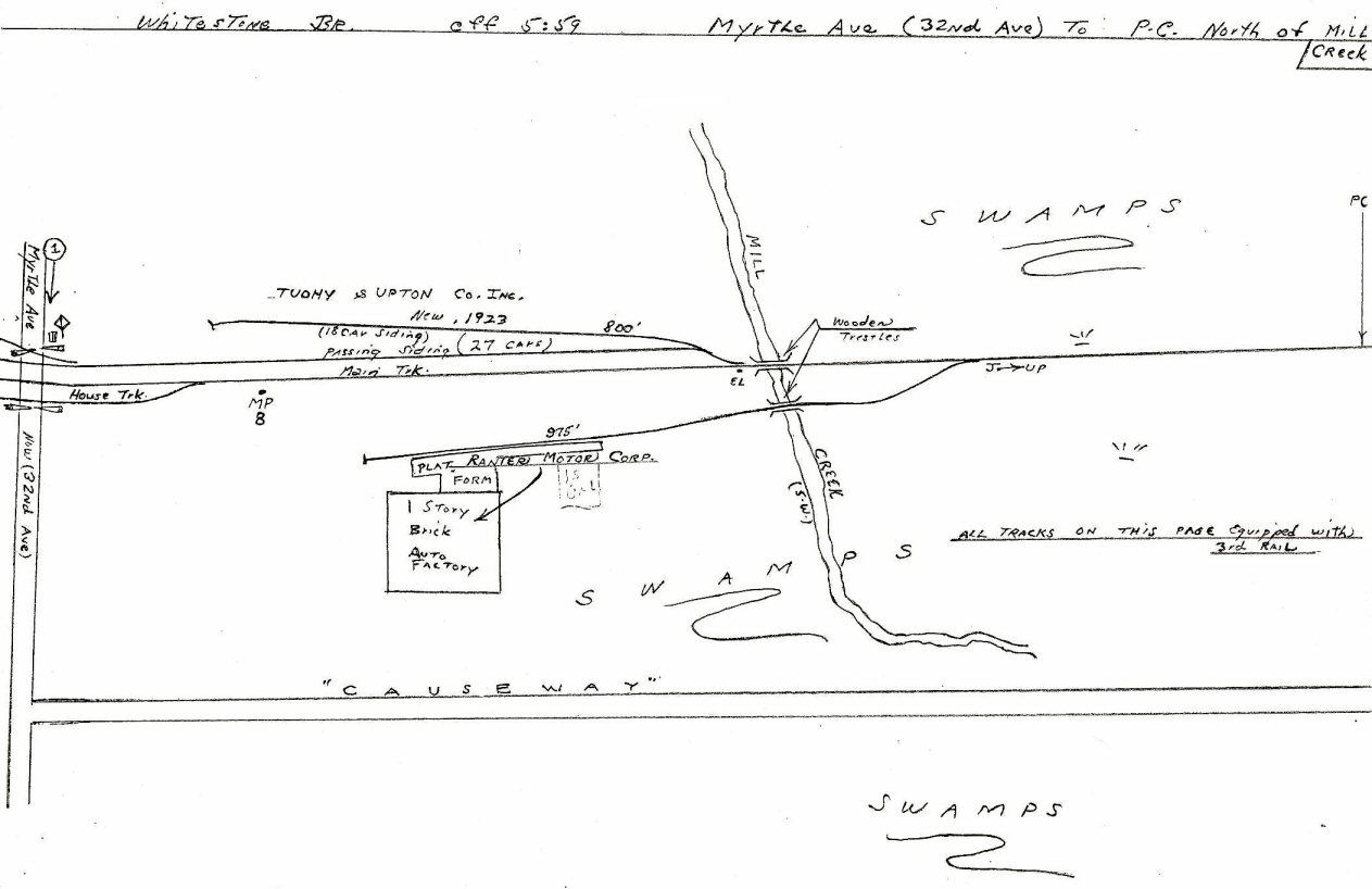
| Whitestone Freight Activity and Sidings � Mileage from WJ Tower (Winfield Jct.) | |||||
|
Flushing Bridge Street |
|||||
|
WHITESTONE JUNCTION |
|||||
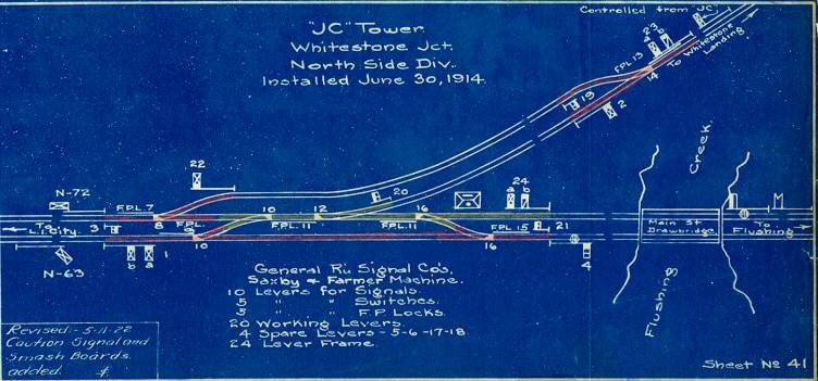 1922 JC Tower - Whitestone Jct. Interlocking blueprint Archive: Art Huneke
|
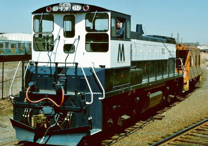
LIRR #152 MP15 at ex-Whitestone Junction turnout 4/15/77 The station at the time of the photo was Shea Stadium. The Transit facility, in the left background is Corona Yard. The EL station here is Willets Pt. The LIRR yard that used to be there a little further up towards the Corona-Flushing EL was called Corona Yard. The World's Fair located south of the tracks at that spot was called Flushing Meadows. Info: Dave Keller |
%20-%2009-30-35%20(Sperr-Keller).jpg) Looking North across the marshland from the Roosevelt Avenue bridge on September 30, 1935, we see the Corona Meadows team yard which opened in 1926. Prior to that date, all freight was handled at the Flushing, Bridge Street freight facilities on the Whitestone branch. A pair of DD1 electrics with headlights lit are working some freight cars and the freight station is just beyond. At the far right, the former electrified tracks of the Whitestone branch are visible, paralleling the Flushing River. After the Whitestone branch was abandoned in February, 1932, this portion of the branch tracks was left intact to access the team yard from the Port Washington branch. The marshland in the foreground became the site of the large passenger yard constructed in 1938 to handle the layup of passenger trains in service to and from the 1939-40 N. Y. World's Fair trains. It was torn up in 1954, leaving the team yard in place. (Percy Loomis Sperr photo, Dave Keller archive) %20-%2009-30-35%20(Sperr-Keller)%20(Zoom).jpg) This is a close-up view of the Corona Meadows team yard. The former Whitestone branch track at the far right curves in the distance, where it once went across the Flushing River over a swing bridge. |
%20-%2010-18-36%20(Sperr-Keller).jpg) On October 18, 1936, Percy Loomis Sperr photographed the LIRR's Corona Meadows team yard looking northeast. The yard was constructed in 1926 with newer facilities in place in early 1931. While under the jurisdiction of the agent at Corona on the Port Washington branch, the yard was actually constructed between Whitestone Junction and the west end of the Flushing River draw (swing) bridge with access to the team yard via the Whitestone branch. When said branch was abandoned in February of 1932, a short stretch of the original tracks was left in place to continue to allow access to the team yard. In addition, a large passenger layup yard was constructed in 1938 in preparation for trains to and from the 1939-40 NY World's Fair. All tracks were electrified but after 1951, third rail was removed. The layup yard tracks were removed in 1954 but the team yard remained in service. (David Keller archive)
|
||
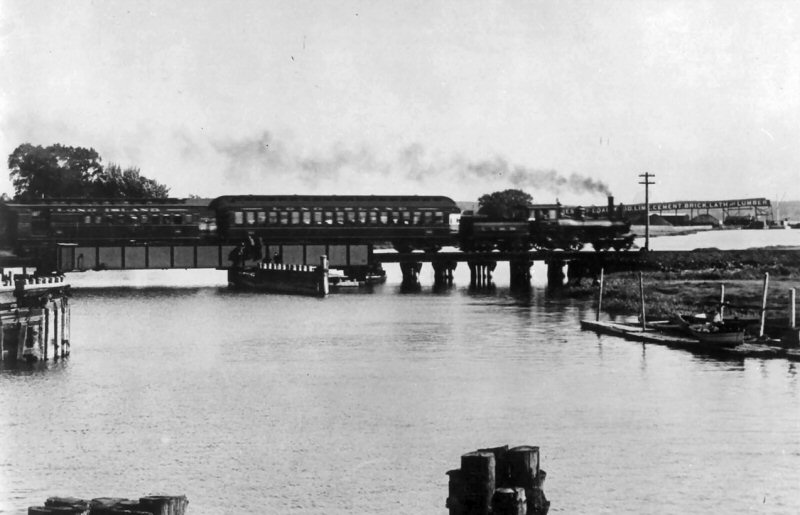 Flushing Creek Swing Bridge Train is eastbound c.1890 |
%20-%20c.%201904%20(Keller).jpg) Swing Bridge Flushing Creek- View N c.1904 Archive: Dave Keller |
.jpg)
Swing bridge trestle over Flushing Creek view SW - 07/06/1917 (Dave Keller) |
|||
%20-%2004-08-1927%20(Sperr-Keller).jpg) Looking southeast from Northern Blvd at the Flushing River bridge, we see the LIRR's swing bridge with bridge tender's cabin at the left as it looked on April 8, 1927. Beyond the bridge is the long-established and high-end furniture and rug company of W & J Sloane. In the left foreground is a barge docked at the Commonwealth Fuel Company. (Percy Loomis Sperr photo, Dave Keller archive)
|
%20-%2005-30-38%20(Sperr-Keller).jpg) Looking south from Northern Blvd. as it crosses over the Flushing River Bridge, we see the former track and ROW of the abandoned Whitestone branch truncated on the west side of Flushing River. The Corona Meadows Team Yard is at the far right with some freight activity underway. The layup yard for New York World's Fair trains has not yet been constructed. In the distance is the Roosevelt Ave. bridge and beyond it can be seen the symbols of the 1939-40 New York World's Fair: the Trylon and bottom half of the Perisphere under construction. Image photographed on May 30, 1938 by Percy Loomis Sperr. (Dave Keller archive) %20-%2005-30-38%20(Sperr-Keller)%20(Zoom).jpg) |
.jpg)
S2 #455 in original "as-delivered" black livery, gold lettering, small road numbers, and white pilot is switching a boxcar and a pole car at the old Whitestone Junction, on the Port Washington branch just east of the former 1939 NY World's Fair grounds on June 2, 1951. This view is looking SE from the old pedestrian overpass which was constructed for the fair, so visitors arriving by IRT trains could cross the LIRR tracks and access the entrance. Directly behind the photographer was the site of the old United Nations station, which was in service at the time this photo was taken. "JC" tower was once located inside the switch to the former Whitestone branch in the left background. By 1952, both the overpass and the United Nations station were history. (Will V. Faxon, Jr. photo, Dave Keller archive) |
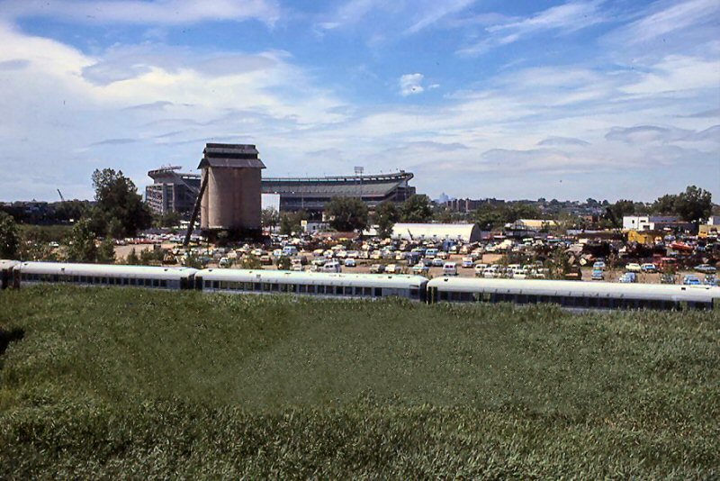 Anchor Coal Co. (see map MP6-7 above left - location #8) view SW toward Shea Stadium - ex-World's Fair site 1979. The coaches are awaiting scrap in what once was the Corona Yard. Photo: Richard Braun |
||
| BRIDGE STREET | |||||
.jpg) Looking north toward the grade crossings of Lawrence St. (left; now College Point Blvd.) and 36th Ave. (right), west of Flushing, Bridge Street station on 09/05/1910. Compare this view with the view at right. (Dave Keller archive) |
.jpg) Grade crossing of Lawrence St. looking S. - 07/05/1917 (Dave Keller archive) |
-36th%20Ave.%20(R)%20&%20Xing%20Tower%20W.%20of%20Flushing%20Bridge%20St.%20Sta%20(View%20NE)%20-%2003-13-32%20(Sperr-Keller).jpg) Looking NE towards the crossings of Lawrence Street (at the left) and 36th Ave. (at the right) with the elevated crossing tower and related outhouse on March 13, 1932, shortly after the branch was abandoned. These crossings were just west of the Flushing, Bridge St. station. The tracks curved around the right side of the building visible behind the crossing tower, then crossed Northern Blvd. (Bridge St.) and accessed the station on the north side of the street. Compare this view with the similar view shot 21-1/2 years earlier in 1910. (Percy Loomis Sperr photo, Dave Keller archive) |
%20Flushing%20(Bridge%20St)-View%20SE%20-%2003-12-32%20(Sperr-Keller).jpg) Grade crossing and elevated watchman's tower - 36th Ave. (formerly Old Lawrence St.) at Flushing (Bridge St. station around curve at far right) - view N. (railroad E.) on 03/12/32, shortly after abandonment of branch. (Percy Loomis Sperr photo / Dave Keller archive)
|
||
.jpg) MU combine and train over Old Lawrence St., negotiating the curve just west of Flushing (Bridge St.) station. View N. (railroad E.) - c. 1925 (Dave Keller archive) |
.jpg) Tracks and ROW looking W. from Broadway, Flushing (Bridge Street) toward Old Lawrence St. - 07/06/1917 (Dave Keller archive) |
.jpg) Grade crossing of Bridge St. (Northern Blvd.) at Flushing (Bridge St.) station. Swift & Co. wooden 2-1/2 story building at left. LIRR station covered platform visible beyond at the crossing gates. View E. - 07/06/1917 (Dave Keller archive) |
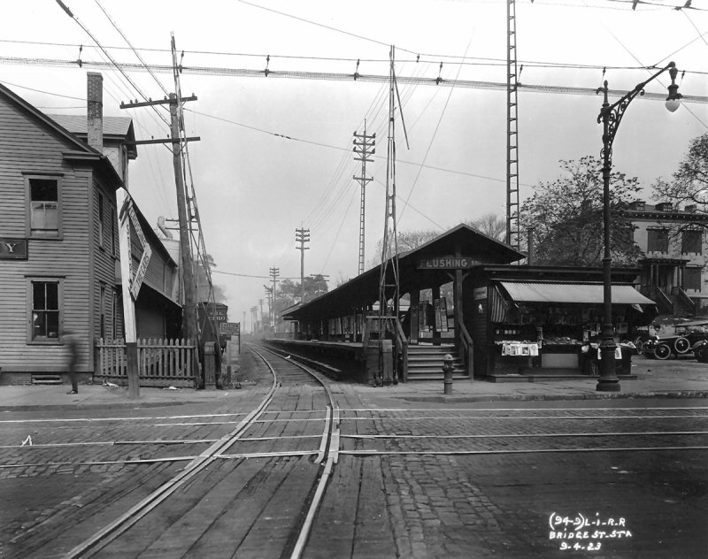 Flushing (Bridge Street) station- view NE 9/04/1923 Lundin Collection, New York Transit Museum |
||
.jpg) Flushing (Bridge Street) station (view E) - Reefer cars at left on siding for Swift & Co. Old newsstand facing street at end of station platform - c. 1925 (James V. Osborne photo/Dave Keller archive)
|
%20-%2003-03-32%20(Sperr-Keller).jpg) Bridge Street Station, Flushing View N 1932 Looking north on March 3, 1932, we see the closed station at Flushing Bridge Street (Northern Blvd). (Photo upper right) The NY & Queens Transit trolley tracks are visible in the cobble-stoned center of the street. Swift & Company with their siding is at the left and a beat cop appears to be watching something, or posing for the camera. When the branch was in service, there was a large newsstand at the street end of the platform but with abandonment of the line, the newsstand was removed. (Percy Loomis Sperr photo, Dave Keller archive)
|
%20-%2003-03-32%20(Sperr-Keller).jpg) Looking NE from just north (railroad east) of the Flushing Bridge Street station, we see the right-of-way and tracks of the passing siding at the left, the main track to its right and the throat of the Flushing Bridge Street team yard further right. The semaphore block signal is at the left and is cantilevered over the passing siding to allow the signal to be above the main track. Just beyond the signal mast, a portion of the section house is visible, along with planked area between the rails to allow maneuvering of the handcar. The freight house is in the center background and looming beyond it is the holder for the Flushing Gas Works. This view was photographed on 03/03/32, just shy of two weeks after the branch was abandoned on 02/19/32 (Percy Loomis Sperr photo/Dave Keller archive) |
%20-%2003-03-32%20(Sperr-Keller)%20(Zoom).jpg) This is a zoom image showing more closely the items indicated in the photo left. |
||
.jpg) View of the Flushing (Bridge St.) team yard, looking NE towards the Flushing Gas Works - 03/03/32 - Out of service with branch abandonment on 02/19/32 (Percy Loomis Sperr photo / Dave Keller archive) |
.jpg) Grade crossing of Myrtle Ave. (now 32nd Ave.) east of Flushing (Bridge St.) station, at the LIRR's team yard. Freight house at right in shadow. View E. - 07/06/17 (Dave Keller archive) |
-Flushing%20-%2003-03-32%20(Sperr-Keller).jpg) Looking north along the abandoned ROW from Myrtle Ave. (32nd Ave.), just north of the Flushing Bridge Street station on March 3, 1932, we see the west end of the freight/team yard. The switch in the foreground has been removed but the ties and third rail are still in place. (Percy Loomis Sperr photo, Dave Keller archive) |
|||
| COLLEGE POINT | |||||
 Whitestone Branch - Post 1889 College Point map zoom
|
 College Point 3/1886 Sanborn map
|
 College Point 1/1892 Sanborn map |
 College Point 1/1897 Sanborn map |
||
%20-%2003-03-32%20(Sperr-Keller).jpg) This is the crossing of 20th Ave. at 128th St. at the southern end (railroad west) of the College Point station platform. The view taken on March 3, 1932 is looking southeast. (Percy Loomis Sperr photo, Dave Keller archive) |
.jpg) College Point station (rear view) looking geographically east along 18th Ave. - c. 1890 (Art Huneke archive) |
.jpg) College Point station (trackside view) looking geographically SW - 1906 (Jason Antos archive) |
|||
.jpg) College Point station (trackside view) looking NW (railroad E) c. 1925. Note in this image that while the main track at the depot side has a high-level, wooden platform, which remained up to the end of branch service, there is also a low, concrete platform with electric lamp posts running alongside the passing siding, as well as a mid-track fence, giving the impression of double track, which did not exist here. What's interesting to note is that in subsequent images on this page, these items no longer exist. (James V. Osborne photo, Dave Keller archive) |
.jpg) College Point station (trackside view) looking NW (railroad E.) - Freight house at right background - c. 1930 (Fred Weber photo / Art Huneke archive) |
%20-%2003-03-32%20(Sperr-Keller).jpg) Spinning around, and looking north from the 20th Ave. crossing on March 3, 1932, the photographer captures the closed station at College Point with curved, high-level wooden platform. The switch in the foreground with track curving to the right is the southern end (railroad west) of the passing siding. (Percy Loomis Sperr photo, Dave Keller archive) |
.jpg) Rear, broadside view of College Point station looking geographically E along 18th Ave. (The tracks physically extend north/south at this portion of the branch.) - 03/03/32 Out of service with branch abandonment on 02/19/32 (Percy Loomis Sperr photo / Dave Keller archive) |
||
%20-%2003-03-32%20(Sperr-Keller).jpg) Standing alongside 127th St. and looking north on March 3, 1932, the photographer captures a rear, street-side view of the closed station at College Point at 18th Ave. Notice the limited parking space. At the time the station was constructed, parking wasn't an issue as passengers would either walk to and from the depot or take a carriage to be dropped off or picked up. Commuting on this branch wasn't as we know commuting today. It appears it remained the same as late as branch abandonment on February 19, 1932, as there still are no parking spots other than for taxis. (Percy Loomis Sperr photo, Dave Keller archive) |
.jpg) Rear view of College Point station looking geographically NE along 127th St. (The tracks physically extend north/south at this portion of the branch.) - 03/03/32 Out of service with branch abandonment on 02/19/32 (Percy Loomis Sperr photo / Dave Keller archive) |
%20-%2003-03-32%20(Sperr-Keller).jpg) Standing in the freight/team yard on March 3, 1932, the photographer looks due west and captures the front/trackside view of the closed College Point station. In the foreground are the two team tracks. Note that, while the depot windows at ground level are boarded up, the upper windows are still visible and accessible, with clothes dangling from one of the center windows. Apparently, the agent and his family resided in the upper level, as was the case at many 2-story depots (Whitestone included), and, while the branch and ticket agency closed on February 19, 1932, this structure remained standing for a little over another 2 1/2 years, possibly to allow the family time to relocate amongst other LIRR reasons unknown to us at this time. The building was razed on September 19, 1934. (Percy Loomis Sperr photo, Dave Keller archive) |
.jpg) College Point freight house in team yard - view geographically NE (The tracks physically extend north/south at this portion of the branch.) - 03/03/32 Out of service with branch abandonment on 02/19/32 (Percy Loomis Sperr photo / Dave Keller archive)
|
||
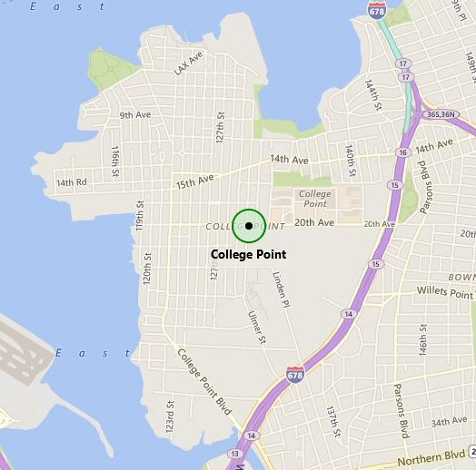 College Point Google roadmap 2016 |
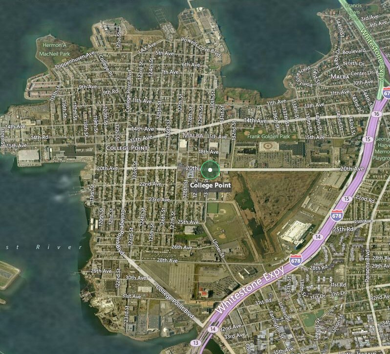 College Point - Google Satellite view 2016 |
||||
|
STAFF CABINS Used for controlling train movements on the Whitestone Branch after head-on-collision of MU trains east of College Point 9/22/13. IN USE 1913 � 1926 ONLY |
|||||
|
CABIN B ON PLATFORM JUST EAST OF FLUSHING BRIDGE ST.
PASSENGER STATION |
|||||
.jpg) MU combine car #1371 (on train #308) in aftermath of head-on collision between eastbound train #308 and westbound train #311 just east of College Point station - 09/22/13 (Dave Keller archive) |
.jpg) MU motor #1526 (on train #311) in aftermath of head-on collision between eastbound train #308 and westbound train #311 just east of College Point station - 09/22/13 (Dave Keller archive) |
||||
.jpg) ROW-View N toward 14th & 15th Aves Overpass - College Point - 3/03/32 (Sperr-Keller |
Looking north along the ROW from just north of the College Point station on March 3, 1932, we see the overpass of 14th / 15th Avenues. At the left is a cantilevered semaphore block signal, at the right of the main track is the passing siding and at the far right are the tracks from the northern end (railroad east) of the freight/team yard. What was unusual about this branch was that, prior to the deadly head-on collision of two MU electric trains just east of the College Point station on September 22, 1913, trains along this single-track branch were operated with only employee timetable and pocket watch. There were no signals installed. As a result of the wreck, a "staff" system was put into effect on October 21, 1913 and remained in use until semaphore block signals were installed in October, 1926. (Percy Loomis Sperr photo, Dave Keller archive) |
||||
%20-%2003-03-32%20(Sperr-Keller).jpg) Overpass 14th/15th Aves View N of College Point station 3/03/32 (Sperr-Keller) |
Here is a close-up of the 14th/15th Avenues overpass just north of the College Point station. This March 3, 1932
(after abandonment) view is looking north (railroad east) with the switch and track to the passing siding
(which also fed the freight house and team tracks) curving off to the right in the foreground. Robert Emery, when drawing his maps of the branch in 1957, indicated this overpass was designated as "W95" but was unable to find a date as to its construction. He notes the structure, which was a combination of wood and large stones, was built pre-1908. Judging by the very old style of construction, it would appear that it's possible that this overpass was even older than that, having maybe been built when the branch was constructed to Whitestone in 1869. (Percy Loomis Sperr photo, Dave Keller archive) The electric lock stand to the right of the hand-operated switch, as well as manual block signals at Flushing-Bridge St and Whitestone Landing, were installed in 10/1926. This electric lock was controlled from lever 31 at WE Block Station in Whitestone Landing station. Lever 32 controlled the eastbound manual block signal at College Point and the westbound signal leaving Whitestone Landing. The machine was a US&S Style TC table-top with only the two levers, 31 and 32. JC Tower at Whitestone Junction had signal, switch and lock levers up to #30. Research: Jeff Erlitz
|
||||
%20from%2015th%20Ave.%20Overpass%20-%20College%20Point%20-%2003-16-32%20(Sperr-Keller).jpg) ROW view N from 5th Ave. overpass just N of College Point 3/16/32 (Sperr-Keller) |
ROW and tracks looking north (railroad east) from the 15th Ave. overpass just north of the College Point station. The tracks along the Whitestone branch headed north after leaving the LIRR's Port Washington branch at "JC" tower in Flushing Meadows traveling through College Point and this image shows them curving sharply to the right to head in an eastward direction towards Malba and Whitestone stations. This image was taken on 3/16/32, shortly after the branch was officially abandoned on 2/19/32. (Percy Loomis Sperr photo, Dave Keller archive) |
||||
| MALBA STATION | |||||
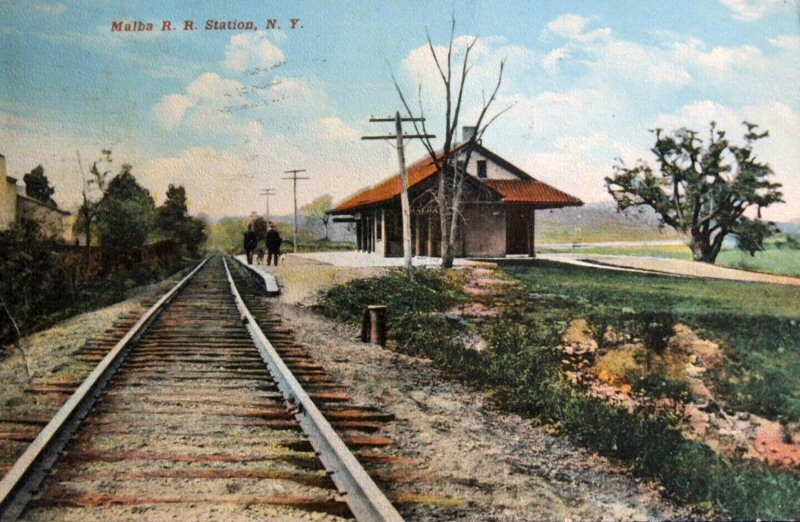 Malba Station postcard c. 1910 eBay This postcard image would have to have been shot between 1909 and sometime before 10/22/1912 as there are no high-level platforms in place, no third rail indicated, nor any signs of installation being underway. Research: Dave Keller |
.jpg) Malba station (rear view) looking SE (railroad E) - 1921 (LIRR valuation photo / Art Huneke archive) |
.jpg) MU train westbound at Malba station - View NE (railroad E) - c. 1925 (James V. Osborne photo / Dave Keller archive) |
.jpg) Malba station view NE in semi-rural Queens (The tracks head due east along this portion of the branch) - 03/03/1932 Out of service with branch abandonment on 02/19/32 (Percy Loomis Sperr photo / Dave Keller archive) |
||
%20-%2003-03-32%20(Sperr-Keller).jpg) |
This view is looking east at the abandoned Malba station on March 3, 1932. The LIRR's Whitestone branch, along with its stations, freight stations and manned crossings was taken out of service twelve days earlier on February 19, 1932. This picturesque wood and stucco station with Spanish tile roof was constructed in 1909 for the convenience of residents of the new community of Malba being developed in Whitestone. The tracks elevated slightly here and the depot was constructed on a slightly elevated piece of land with a broad circular driveway at the rear of the building, useful for dropping off and picking up passengers without having to park in a lot. I don't believe ridership ever required a parking lot. Originally constructed with a low-level platform for steam-drawn trains, the wooden, high-level platform seen here was added when the branch was electrified on October 22, 1912. While I don't have a date for closing of the ticket agency, I think it shut down sometime in the late 1920s. The late station agent James V. Osborne worked this station as an extra clerk around 1925. |
||||
%20-%2003-03-32%20(Sperr-Keller.jpg) |
Rear view of the Malba station looking SE from an unpaved 11th Avenue
on March 3, 1932 shortly after the line's abandonment. Note the
sweeping curved roadway to drop off and pick up riders. This entrance
is curbed and sidewalked and appears to possibly be paved . . . quite
a juxtaposition with the dirt version of 11th Ave. Today's 143rd Place
would be on the far side (east side) of the depot building. (Percy
Loomis Sperr photo, Dave Keller archive and data)
|
|
|||
%20-%2003-03-32%20(Sperr-Keller).jpg) |
This view is looking east from just east of the Malba station, toward the 144th St. (Malba Drive) overgrade crossing located just past the curve. You can make out the white concrete stanchion for the girder trestle. Malba Drive is seen in the right background behind the large, landmark tree. This view was also photographed on March 3, 1932, shortly after abandonment. (Percy Loomis Sperr photo, Dave Keller archive and data) |
|
|||
-E.%20of%20Malba%20Station-Whitestone,%20NY%20(View%20N)%20-%2003-03-32%20(Sperr-Keller).jpg) |
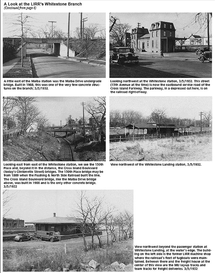
Looking north along 144th Street (Malba Drive), we see the LIRR's undergrade crossing. Built in 1908, this was one of the last two trestles built on the branch (Cross Island Blvd. / Clintonville St. (or Rd.) was the other. 11th Avenue is visible on the other side of the trestle on the right, intersecting Malba Drive. (Percy Loomis Sperr photo, Dave Keller archive and data)
Zooming in to the sign on the side
of the Malba Drive girder trestle, |
|
|||
| WHITESTONE STATION | |||||
|
|
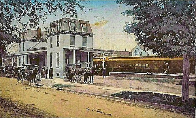 Whitestone Station colorized post card c.1900 Archive: Tom Byrne |
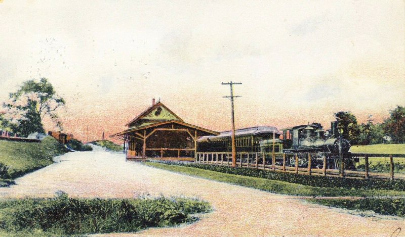
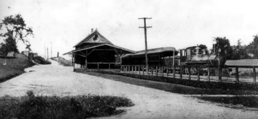
 Whitestone Station rear view with freight house in background View NE c.1910 (eBay image) |
%20(e-Bay)%20(2).JPG) Whitestone Station (trackside view - railroad W) - 8/17/1914 (eBay image) |
||
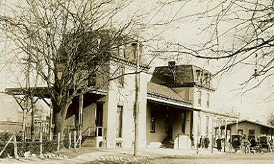
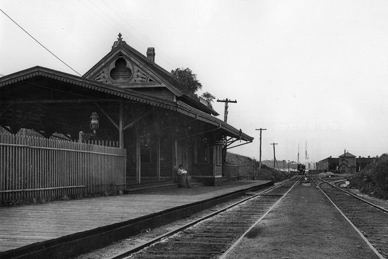
 Whitestone Station View W c.1922 Photo: Eugene L. Armbruster Archive: NY Historical Society Note: Porte cochere streetside |
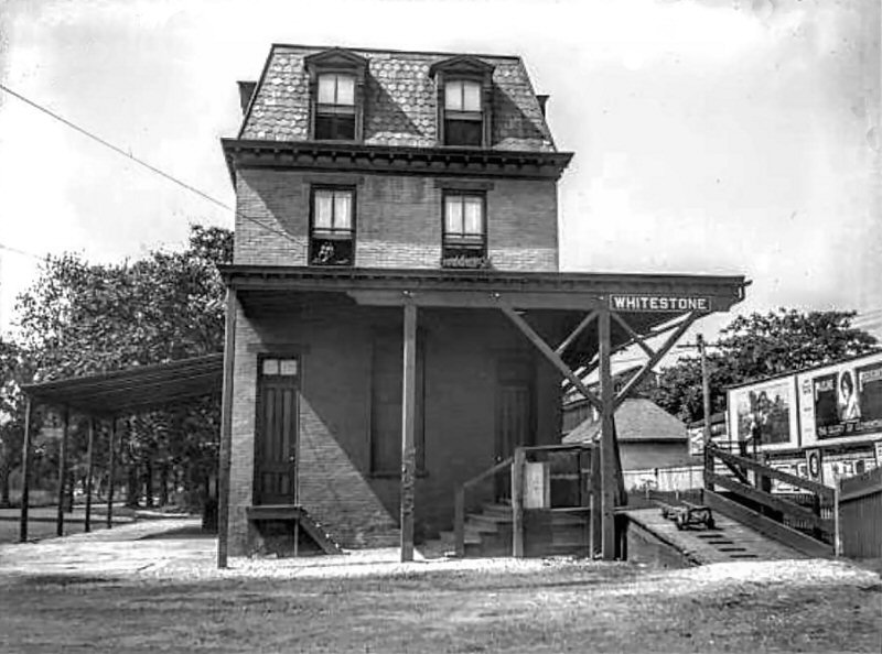
.jpg) Whitestone station (rear view - railroad W) minus porte-cochere on 3/05/1932 shortly after branch abandonment. While the windows are boarded up on the ground floor, it appears the former agent and his family are still in residence on the upper floors as indicated by the wash hanging out to dry on a line stretching to a nearby tree. (Percy Loomis Sperr photo / Dave Keller archive) |
.jpg) Whitestone station looking NE at 15th Ave. - 3/05/32. (Percy Loomis Sperr photo/Dave Keller archive) |
.jpg) A close-up of the former freight house and possibly Depot #1 from 1869. Check out the railroad-style architecture. 3/05/1932 (Percy Loomis Sperr photo Dave Keller archive) |
||
.jpg) Whitestone Station - View E c.1925 (Osborne-Huneke) Note: The rectangular station sign, prior to 1929 Pennsylvania Keystone station sign replacements. |
.jpg) Whitestone Station Keystone Sign close-up 3/05/1932 (Percy Loomis Sperr photo / Dave Keller archive) |
|
|||
|
In this close-up of the former freight house, in use as a taxi building in 1932, it looks architecturally as though it MAY have been the original depot building from 1869 and relegated to use as a freight / express house after 1871 when the 3-story depot was constructed. This was done at Good Ground (Hampton Bays) and several other sites on the LIRR. You'll note the architectural style is very much like those used on the SSRR of LI which also dated from the 1868-70 era. In the early street image of Whitestone depot posted above, one can see the exact same structure when in use as the freight house, but with the trackside eaves extended and apparently no bay window. Also it appears to be of vertical board-and-batten construction, in contrast to the 1932 image which appears to be of brick. This was probably the then-popular brick-style asphalt panels installed over the wood frame, probably so nobody had to paint the walls. When freight service dwindled to nothing, it may have been sold or leased to the taxi company who may themselves have applied the asphalt brick panels, cut back the trackside overhanging eaves as they were no longer needed and added an office bay window. Emery indicates a high-level platform around the structure which would explain why the top of the door and the top of the adjacent window are in line in the older view but with the removal of the high-level platform, the door was lowered to street level for access, now making the top no longer in alignment with the window. (Dave Keller's thoughts) |
|||||
 Two bridges over abandoned Whitestone branch of Long Island Railroad, at 150th and Murray Streets., Whitestone. 05/08/1935 Photo: Irving Kaufman � Daily News 1999 |
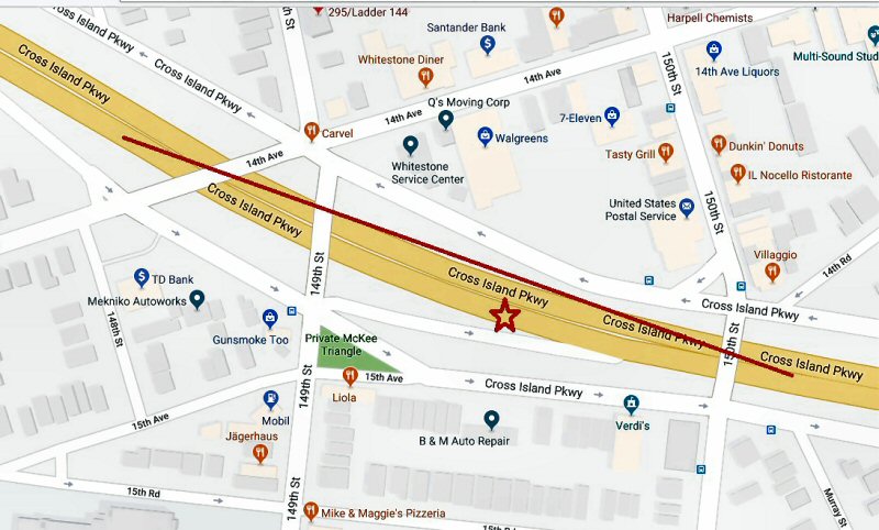
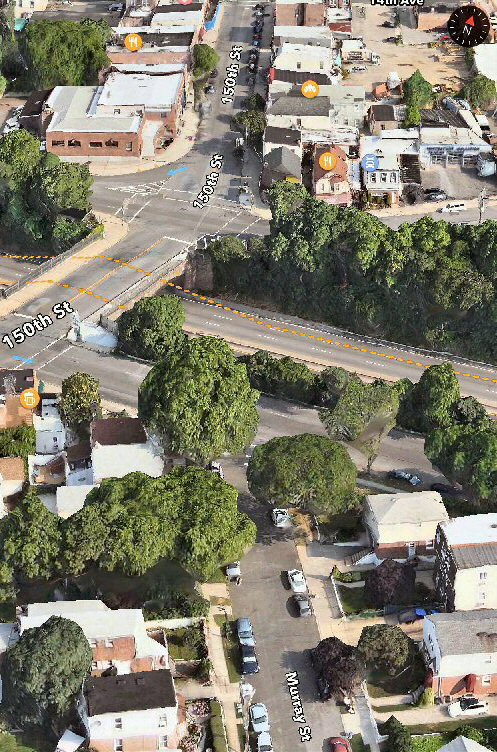 Abandoned Whitestone Branch in dash line on current Cross Island Pkwy. Photo: Google maps 2014 |
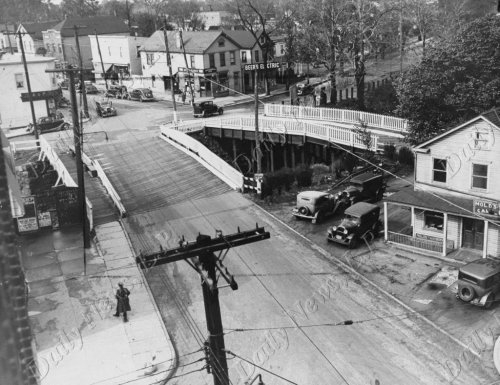
.jpg) Looking NE from the Murray St. overpass just east of the Whitestone station, we see the 150th Place wooden overpass and beyond it, the steel and concrete overpass of Cross Island Blvd (later Clintonville St). In the center background we see the onion-shaped dome of St. Nicholas' Russian Orthodox Church. In this view shot on March 5, 1932, a short time after the branch was abandoned, we see the tracks curving to the north, heading towards the former terminus of the branch at Whitestone Landing. The Murray St. and 150th Place overpasses have long since been removed but the Clintonville St. overpass has been replaced with a newer structure spanning the Cross Island Parkway which was constructed atop the LIRR's Whitestone branch ROW in this section of Whitestone. (Percy Loomis Sperr photo, Dave Keller archive) |
 The 1908 steel and concrete overpass of Cross Island Blvd. (now Clintonville St.) east of the 150th St./Murray St. twin bridges as it appeared on a colorized postcard c. 1912. This view is looking SE. Archive: Dave Morrison |
||
%20Overpass%20E%20of%20Sta-Whitestone,%20NY%20(View%20NE)%20-%2003-05-32%20(Sperr-Keller).jpg) Here's a closer view of the steel and concrete overpass of Cross Island Blvd (Clintonville St.) which bears a construction date on its side of 1908. Looking NE on March 5, 1932, we see St. Nicholas' Russia Orthodox Church with onion-shaped dome and, to the right of it, the First Church of Christ, Scientist. (Percy Loomis Sperr photo, Dave Keller archive) |
.jpg) This view is looking NE from the Cross Island Blvd. (later Clintonville St.) overpass towards the old 14th Ave. overpass in Whitestone, NY on March 5, 1932, a mere two weeks after the branch was abandoned. In the foreground is MP 11 and in the distance, the tracks are making their curve northward to the end of the line at Whitestone Landing. (Percy Loomis Sperr photo, Dave Keller archive) |
.jpg) The wooden trestle over the LIRR tracks at 14th Ave. just east of the Whitestone station. The very old house appears to perch extremely close to the depressed LIRR tracks in this March 5, 1932 image, taken shortly after the branch was officially abandoned the month prior. How'd you like to have to paint all the pickets in those fences? (Percy Loomis Sperr photo, Dave Keller archive) |
|
||
.jpg) ROW and tracks looking east from the 14th Ave. trestle towards the 12th Road grade crossing and shanty in Whitestone (see image of this crossing and shanty posted on this page). The tracks are making their sweeping curve to the north as they cover the short remaining distance to the branch terminus at Whitestone Landing in this image from 3/5/32. (Percy Loomis Sperr photo, Dave Keller archive) |
.jpg) Crossing Shanty at 12th Rd. Whitestone Landing 3/05/1932 (Sperr-Keller) |
||||
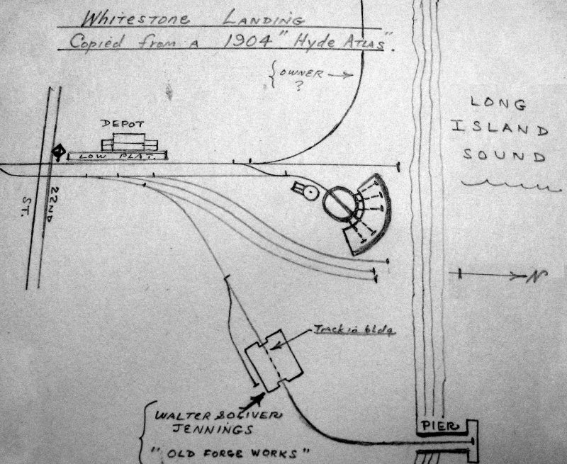
| WHITESTONE LANDING | |||||
|
WHITESTONE LANDING: WHITESTONE TRACKS EXTENDED FROM WHITESTONE:
8/8/1886 AND 1ST TRAIN RAN: 8/9/1886 (V. Seyfried data), DEPOT BUILT AT
WATER'S EDGE ALONG |
|||||
%20-%2003-05-32%20(Sperr-Keller).jpg) The crossing and shanty of 10th Ave. at Whitestone Landing, looking west from 154th St. on 3/05/1932. Check out the diamond crossing sign at the far right, warning turning traffic on 154th St. as well as the sign at actual trackside on 10th Ave! Whitestone Landing station would be to the right, outside this image. The entrance to the station facilities is visible behind the diamond crossing sign at the tracks and gates. (Percy Loomis Sperr photo / Dave Keller archive
|
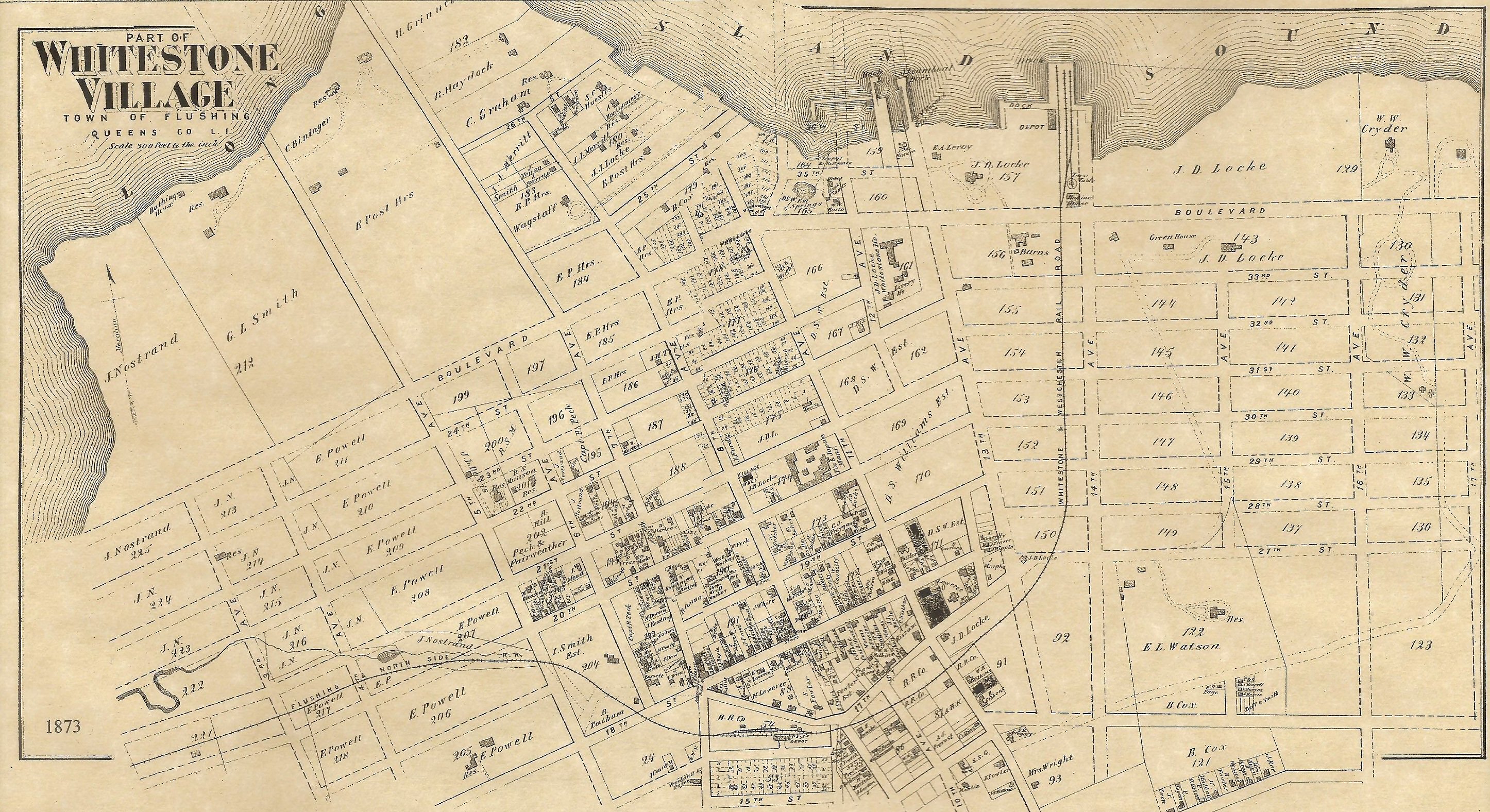
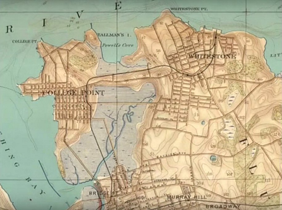 Map of the Whitestone branch. The branch was extended from Whitestone to Whitestone Landing in 1886 and the depot constructed at the water's edge. In 1889 the depot was relocated further inland. This map shows the relocated depot location, indicating a map date of 1889 or later. |
.jpg) A close-up of the shanty and the old, cast-iron electrified 3rd rail warning sign at the 10th Ave. Whitestone Landing crossing. 3/05/1932 (Percy Loomis Sperr photo - Dave Keller archive) |
|||
 Whitestone Landing - Sanborn 1903
|
|
 Whitestone Landing colorized postcard 1906 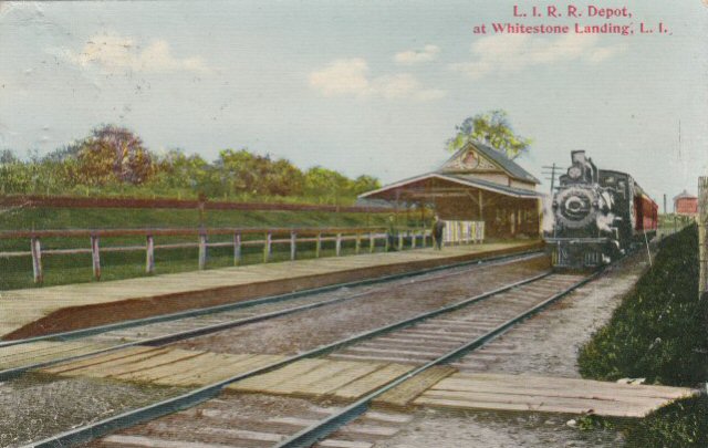 Colorized postcard view of steam locomotive and train westbound at Whitestone Landing station c. summer/1912 (Electrification of the branch occurred in October, 1912 and no third rail is indicated in image) - View NE (railroad E) (eBay image)
|
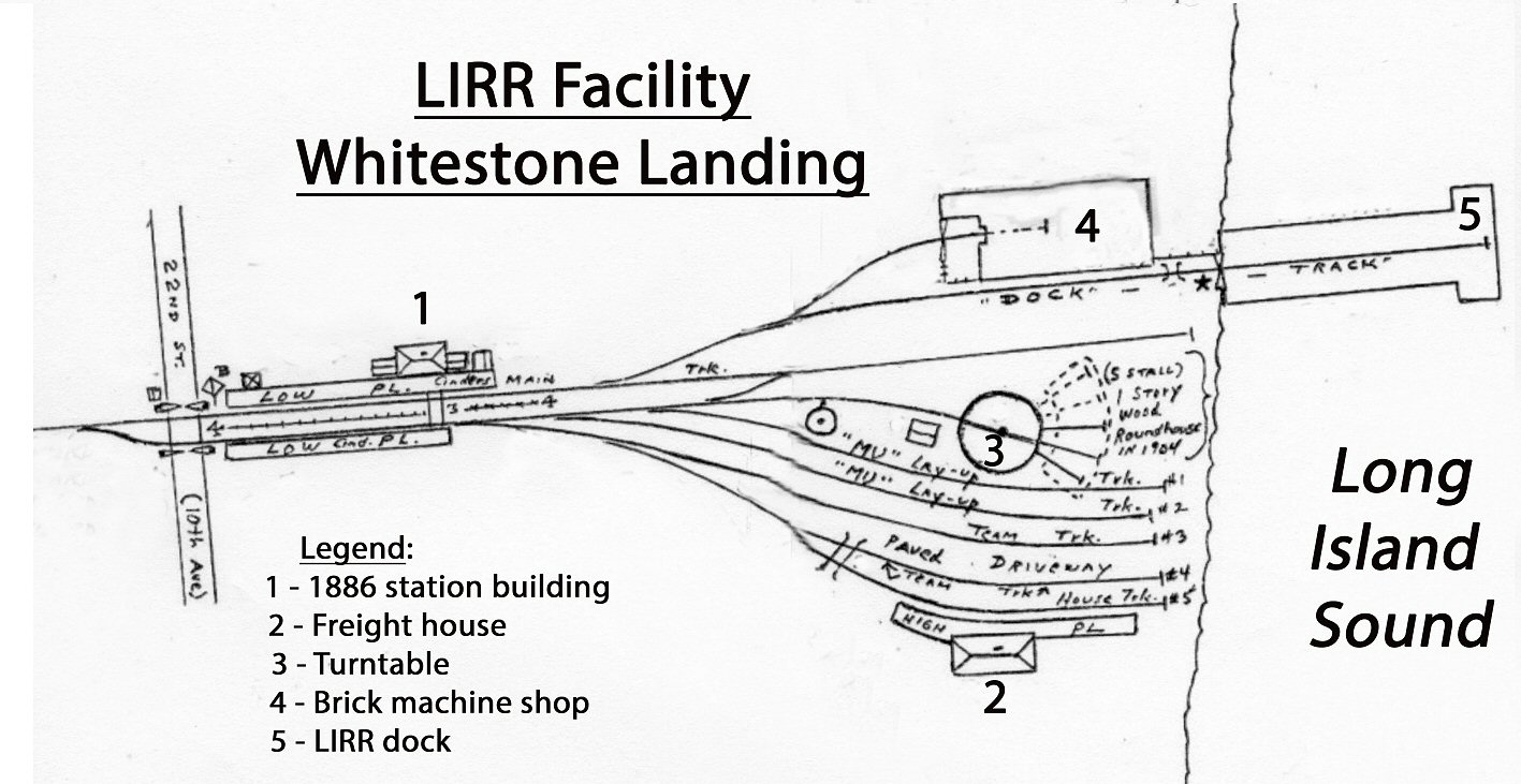
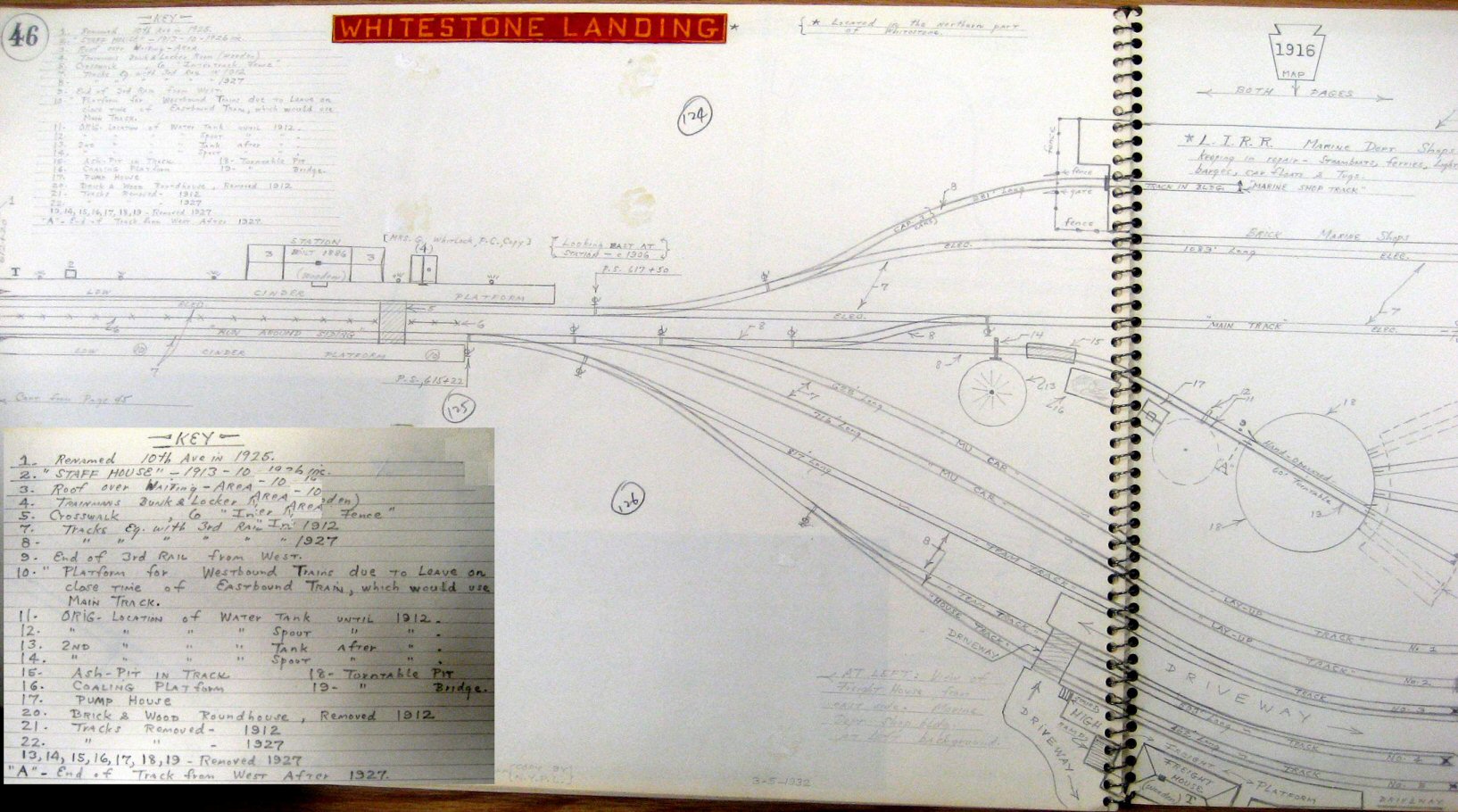 Emery Whitestone Landing Station, yard, and dock 1916 Archive: SUNY Stony Brook 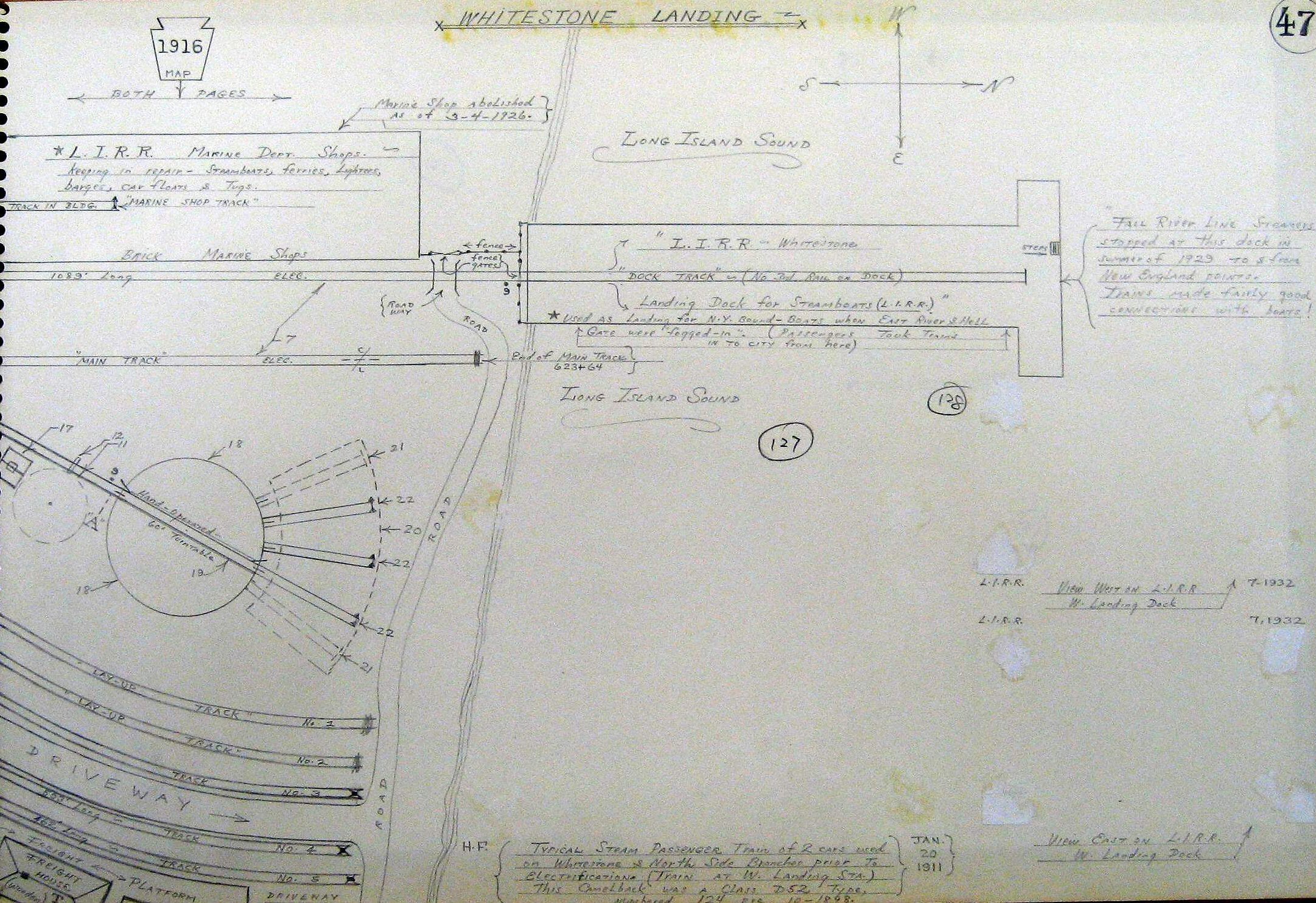
|
||
|
|
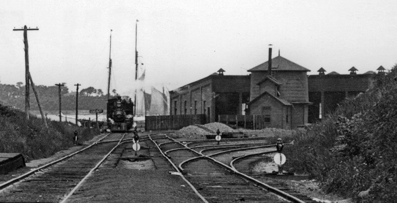
%20-%2003-05-32%20(Sperr-Keller).jpg) This is the freight house at Whitestone Landing, the terminus of the Whitestone branch, as it looked on March 5, 1932, shortly after the branch was abandoned. The view is NW and it would appear some remaining items were being removed from the building, before it was boarded up. The brick structure in the left background was the LIRR's Whitestone Shops which were their tugboat/maritime repair facilities. The waters of the East River, before it joins the Long Island Sound, are visible in the distance. (Percy Loomis Sperr photo, Dave Keller archive) |
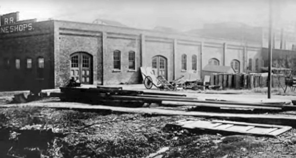 LIRR brick machine shops at water's edge, Whitestone Landing, c. 1890. LIRR tugboats, floats and ferries were repaired at this facility, per Robert Emery's map data. |
|||
|
|
|||||
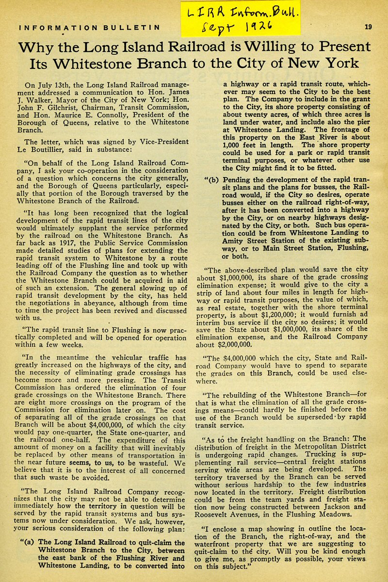 LIRR Information Bulletin - 9/1926 Archive: Dave Morrison
|
|||||
| WHITESTONE BRANCH - POSTSCRIPT | |||||
|
A comparison of Whitestone station pre-1932 branch abandonment and what the area looks like today.
In all actuality, I've seen later-year views of various locations along
the former ROW and it is virtually unrecognizable, either due to highway
construction, or run-down looking commercial construction having been
added at various times since the 1932 abandonment. |
|||||
 Emery map - Whitestone Station Pre-1932 Archive: Dave Keller |
 Ex-Whitestone Station area - Cross Island Parkway 10/2018 Design: Dave Keller |
||||
|
Whitestone Station - View E c.1925 (Osborne-Huneke) |
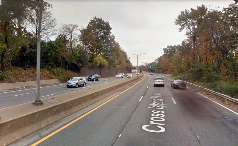 Ex-Whitestone Station area - Cross Island Parkway 10/2016 Source: Google Maps |
||||
|
Both images above are looking east towards the older
and "newer" 150th St. overpass from about the same location,
only approximately 91 years apart. |
|||||


%20-%20Queens,%20NY%20-%201934%20(Keller).jpg)

%20-%2004-08-1927%20(Sperr-Keller)%20(Zoom).jpg)

%20Sharpened.jpg)
%20-%2003-03-32%20(Sperr-Keller)%20(Zoom).jpg)
-Private%20Road-Malba%20Assn-Members%20Only%20-%2003-03-32%20(Sperr-Keller)%20(Sharpened).jpg)

%20(Zoom).jpg)
%20-%20c.%201925%20(Osborne-Keller).jpg)
.jpg)
.jpg)
%20Flushing%20(Bridge%20St)-View%20SE%20-%2003-12-32%20(Sperr-Keller).jpg)
%20-%2003-03-32%20(Sperr-Keller)%20(sharpened).jpg)