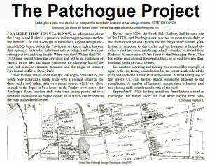
Stretching 110 miles east of New York City to Greenport, Long Island is largely a post glacial flat flood plain devoid of any major obstacles, such as rivers or mountains, providing an ideal terrain for fast flat running of steam locomotives.
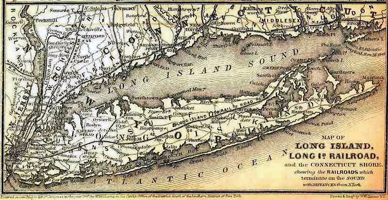 Planned and chartered in April 24, 1834, the Long Island Railroad commenced
operations in 1836 to provide a route to Boston. Stretching 110 miles east
of New York City, Long Island is largely a post glacial flat flood plain,
devoid of any major obstacles, such as rivers or mountains. This geography
provides an ideal terrain for fast flat running for the locomotives of the
era. The engineering
technology had not yet been invented to breech the rocky shore, hills, and
rivers of Southern New England at the time.
Planned and chartered in April 24, 1834, the Long Island Railroad commenced
operations in 1836 to provide a route to Boston. Stretching 110 miles east
of New York City, Long Island is largely a post glacial flat flood plain,
devoid of any major obstacles, such as rivers or mountains. This geography
provides an ideal terrain for fast flat running for the locomotives of the
era. The engineering
technology had not yet been invented to breech the rocky shore, hills, and
rivers of Southern New England at the time.
Slowly, through financial crisis and lack of funding, the line finally in
1844 had reached its terminus at Greenport. The connection at Greenport,
with steamboats, would take passengers across the Long Island Sound to
Stonington, CT and a rail link to Boston by way of Providence, RI.
However, by 1850 a railroad was completed along Connecticut's south shore;
thus opening an all rail route between New York and Boston. Subsequently,
the Long Island Rail Road lost all its Boston passenger and freight
business.
The LIRR grew slowly through national financial crisis and lack of funding
so that it was finally in 1844 that it reached its terminus of
Greenport. Alas, by 1850 a railroad was completed along Connecticut's south
shore; thus opening an all rail route to Boston. Subsequently, Long Island
Rail Road lost all its Boston passenger and freight business.
Having built the line in the sparsely populated central Long Island Pine
Barrens there was little economic reason for the line’s existence. And
struggle it did, but eventually stations were built as folks traveled from
the more populous north and south shore areas bringing goods and seeking
faster westbound transport to New York City and its boroughs.
The South Side Railroad Company of Long Island in 1860 began plans to build
a line directly to serve the south shore communities. By November 1867 it
had reached Babylon and Patchogue, milepost 51, by 1869; the locale of our
story.
 Patchogue, named for a local Indian tribe, by virtue of its shell fishing,
farming and summer tourist trade began to grow. By 1873 an engine house and
turntable where located about 1/4 mile west
of the rail terminus where a brick arch train shed, runaround track and
paint shop resided just a short 5 minute walk north down Railroad Ave to the
center of town. The railroad continuation eastward to Sag Harbor and Montauk
Point, some
70 miles distant, had already been proposed. In 1874, the South Side
Railroad ceased to exist as it was bought out by its competitors and by 1880
the LIRR came into being largely as it looks today. Post Card
Archive: Dave Morrison
Patchogue, named for a local Indian tribe, by virtue of its shell fishing,
farming and summer tourist trade began to grow. By 1873 an engine house and
turntable where located about 1/4 mile west
of the rail terminus where a brick arch train shed, runaround track and
paint shop resided just a short 5 minute walk north down Railroad Ave to the
center of town. The railroad continuation eastward to Sag Harbor and Montauk
Point, some
70 miles distant, had already been proposed. In 1874, the South Side
Railroad ceased to exist as it was bought out by its competitors and by 1880
the LIRR came into being largely as it looks today. Post Card
Archive: Dave Morrison
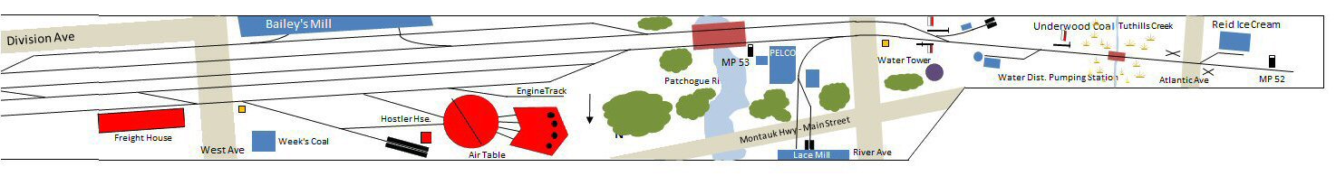
The earliest customers generated enough traffic by 1888 to warrant a team
track and a siding into Bailey's Mill, a large lumber company located just
south of the main line.
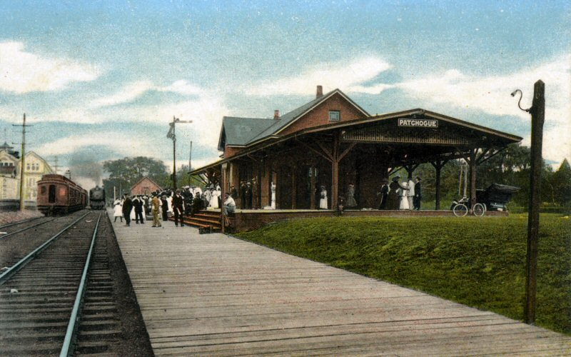
With the dedication of the new railroad station in 1889 the virtual growth
in population made possible by rail access, tourism during the summer months
to the South Shore beaches, and a demand for building materials and products
grew the railroad in this area over the next 30 years. By then the turntable
had been moved into town, amidst protests, a 3 stall engine house erected,
and no fewer than 15 plus industries had sprung up. These included: several
coal supply companies, plumbing supplies, an electric plant, gas company,
brewery, cold storage, pharmaceutical company, and a cement block company to
mention the major customers.
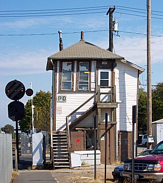
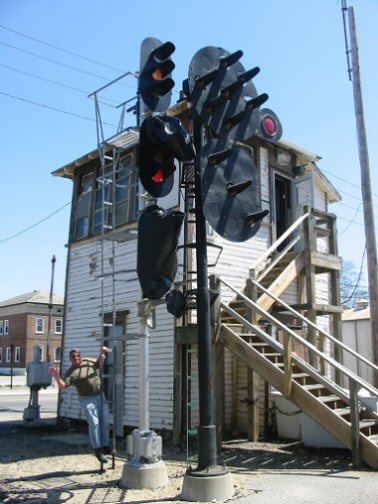
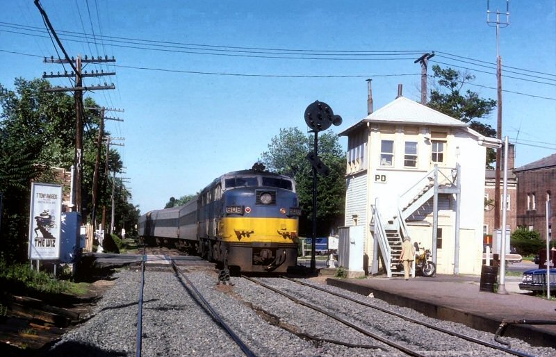 PD Tower came into service 5/29/1912 located on the south side of the tracks
at the east end of the Patchogue station platform. Constructed of wood, it
is the eastern most interlocking tower on the LIRR system. Located on the
south side of the tracks the two 2 story tall structure has a commanding
view of the yard, main line and local industry trackage. PD Tower controlled
an area of approximately 3 miles in length with over 16 sidings and upwards
of 40 customers at its peak period (post WW I). 6/1975
Photo/Archive: Art Huneke
PD Tower came into service 5/29/1912 located on the south side of the tracks
at the east end of the Patchogue station platform. Constructed of wood, it
is the eastern most interlocking tower on the LIRR system. Located on the
south side of the tracks the two 2 story tall structure has a commanding
view of the yard, main line and local industry trackage. PD Tower controlled
an area of approximately 3 miles in length with over 16 sidings and upwards
of 40 customers at its peak period (post WW I). 6/1975
Photo/Archive: Art Huneke
Just west of PD Tower were the REA baggage house, Passenger station, and
freight house. A mere 100 yards further and the turntable, engine house, ash
track, water column and yard tracks were all within sight and tower control.
For many years, and even after the engine house was removed, Patchogue was a
steam locomotive servicing facility and terminal for engines run on the
Montauk branch.
For the rest of the century and onward into the 21st century (razed 2006) PD
Tower stood vigil over the people and freight movements in and out of this
busy switching and servicing locale. Info: Steven Lynch
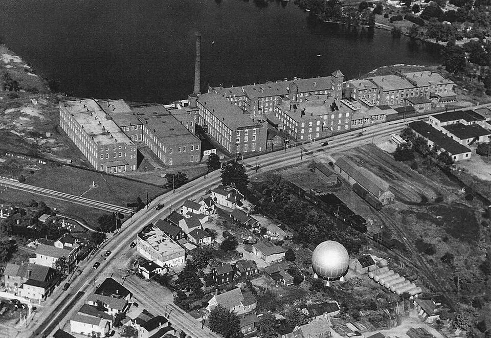
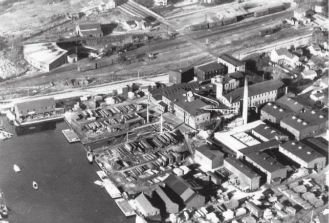
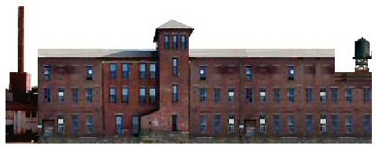
Aerial Lace Mill c.1950 view NE
Photo: Jim Mooney
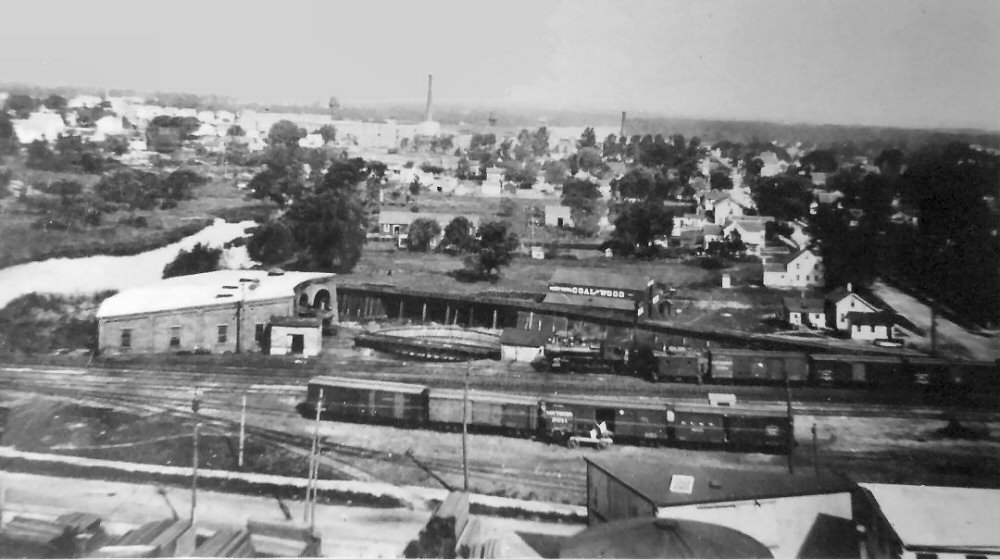
Patchogue view N Turntable, roundhouse , engine service track, Week's Coal yard c.1920 Archive: John Jett
Patchogue yard, Freight Station, and Bailey's Mill Aerial view NE c.1920
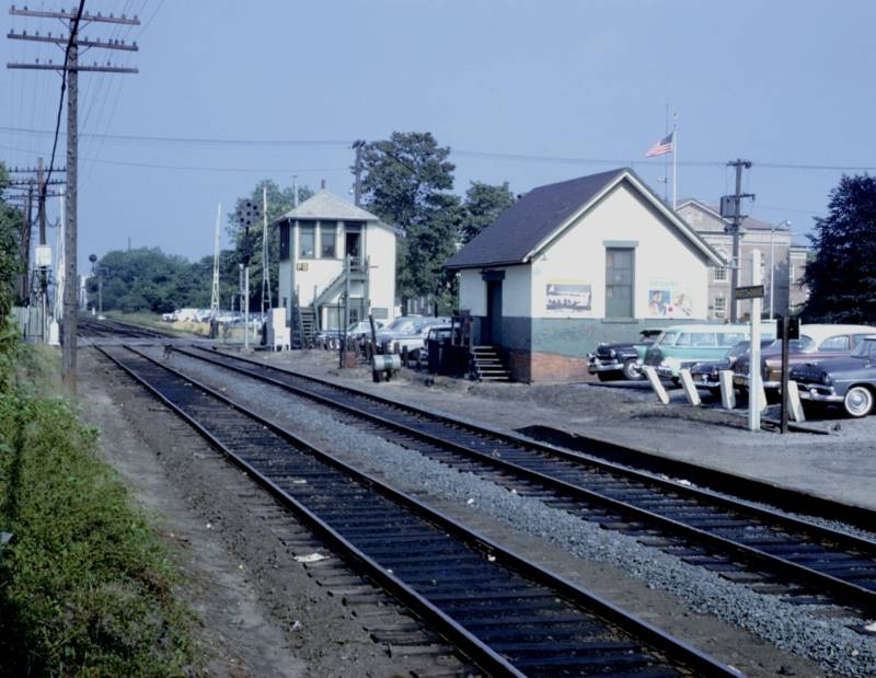
PD Tower Baggage House c.1960
Photo/Archive: Art Huneke
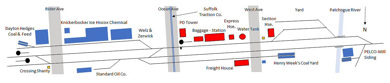
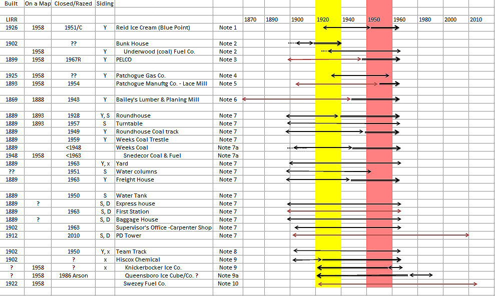
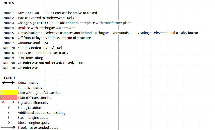
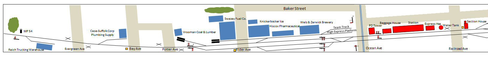
LIRR PATCHOGUE INDUSTRIES
Time period is circa 1885-1915 (and what's remains today).
This area is approx 3/4 mile in length through Village of Patchogue
Eastbound:
Bunk House
E. Bailey & Sons Lumber yard & Mill
1 siding for brick Coal bin
2 sidings for lumber loading
1 siding further east for shipping/receiving
Nelson Morris Co. Dressed Beef
Water Tank
Express Office
Passenger Station (south side of tracks)
Baggage
PD Interlocking Tower
Pair of team tracks
Welz & Zerwick Brewery
South Bay Ice
Hiscox Chemical
Swezey Coal & Feed
Wood & Vernon Coal & Lumber
Red Rose Corp. Plumbing Supplies
T&S Building Supply Company
Sinclair Oils
Standard Oil Co.
Freight House
Week's Coal & Wood Yard
Section House
Engine Oil Facility
Turntable
4 Stall Roundhouse
Hand Car Shed
Tool House
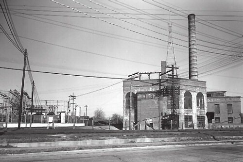
Electric Co.
Monsell Bros. Cement Block
Gas Company
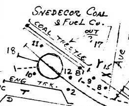
Patchogue Lace Mill Coal Trestle and Shipping/Receiving sidings
Current Standing: 2022
Patchogue - Eastbound
Lead to Bailey Lumber is storage/maintenance shed and 2 sidings (Sperry
Rail test car seen here)
Bowling Alley razed, Federal Park Land was Bailey lumber
Passenger Station (south side of tracks)
PD Interlocking Tower razed August 22, 2006
South side siding: Welz & Zerwick Brewery/Hiscox Chemical - abandoned
Ice House (burned out late '80s) was part of South Bay Ice
Swezey Fuel Oil (no freight delivery) was Swezey Coal & Feed
Single track east to Montauk
National Model Railroad Association (NMRA) -
The Sunrise Trail
Division quarterly publication The Cannon
Ball Fall 2012 - Patchogue Project Introduction
The Patchogue Project Spring 2013 JJ Earl Interview: Patchogue Operations
The Patchogue Project Fall 2017 LDE Patchogue Design
The Patchogue Project Fall 2022 Modeling a Time Machine for Patchogue
Spring 2013 JJ Earl Interview: Patchogue Operations
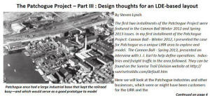
Fall 2017 LDE Patchogue Design
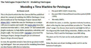
Fall 2022 Modeling a Time Machine for Patchogue
PATCHOGUE TRACK PLANS
Track Plan at a glance
Name: Long Island Railroad, Montauk Branch, Patchogue, NY
Scale: HO
Theme: Local Freight Switching with Commuter Passenger Operations
Periods: Steam c.1925, Steam/Diesel Transition c. 1954, Diesel Era c.1964
Minimum turnout: no. 4
Minimum radius: 18”
Grade: 0% South Shore of Long Island, flat geological glacial moraine flood
plain
Patchogue c.1925
Patchogue c.1948
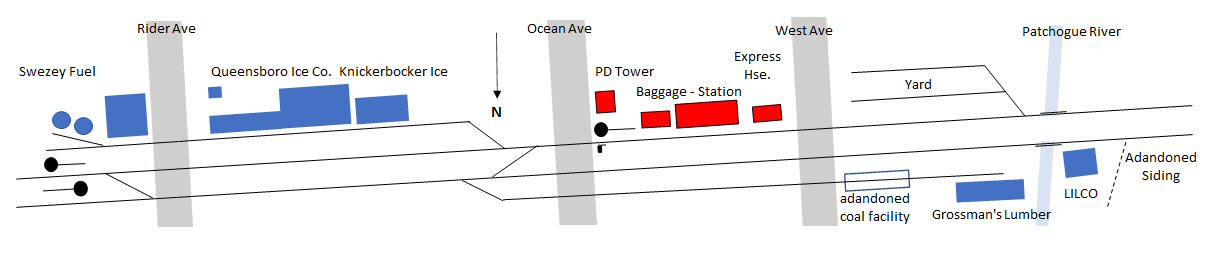
Patchogue c.1962
Patchogue Proto-Freelance Design
Patchogue 1925 original shelf modular concept
 I had
originally envisioned the Patchogue Lace Mill as a selectively compressed back wall
flat N-Z scale obscured by trees as a partial view block around the
Patchogue River/PELCO and an area to stage the Mill coal hoppers and
boxcars.
I had
originally envisioned the Patchogue Lace Mill as a selectively compressed back wall
flat N-Z scale obscured by trees as a partial view block around the
Patchogue River/PELCO and an area to stage the Mill coal hoppers and
boxcars.
Patchogue Lace Mill backdrop Design: Steven Lynch
The signature industry Bailey's Mill can be modeled at the front edge
looking through the windows/lumber shed. The problem arises with
Bailey being south of the LIRR yard and thus off a linear peninsula shelf
layout. I had originally thought you could build it as a partial
building interior view, but it doesn’t identify it as Bailey’s via
signs/look/ease of construction/and future front of layout damage and
maintenance problems. Additionally, the station, express house,
baggage house and all the interesting south of the tracks industries display
their back side; perhaps detracting from the operation visual
spotting/loading/unloading at these locations.
Than I thought about it, further. Most layouts designs are North facing, as my
Oyster Bay endeavor and the Mineola series. As most folks are doing this
naturally; so I thought about
Patchogue with a view south. I tuck the Mill
in the lower right outside corner, and have the following:
 PELCO, followed by the Patchogue River bridge, Bailey’s (perhaps flats)
sidings, easy access to the yard, front view of water tank, express house,
station, baggage house, PD tower, and all the industries south of the
tracks: team tracks, ice plant, brewery, chemical company, and Swezey Coal.
This South view changes the entire perspective of view and design. The yard, turntable, roundhouse, front of the freight house,
and PD Tower are all center stage.
PELCO, followed by the Patchogue River bridge, Bailey’s (perhaps flats)
sidings, easy access to the yard, front view of water tank, express house,
station, baggage house, PD tower, and all the industries south of the
tracks: team tracks, ice plant, brewery, chemical company, and Swezey Coal.
This South view changes the entire perspective of view and design. The yard, turntable, roundhouse, front of the freight house,
and PD Tower are all center stage.
Make no mistake that there are secondary structure elements to include, such
as: turntable, roundhouse, freight Station, water tank, etc., but these are
vanilla components that
do not immediately identify the location as Patchogue.
Modeling a specific era can
be approached in a number of ways:
1. Proto: Adhere to the era track plan and accurately model the buildings
required such as the turntable era c.1925.
b. Transition era(s) up to 1948-1963
c. The yard, water tank, sidings, station, etc. razed post 1963
2. Proto-Freelance:
a. Keep some buildings longer than usual then active/abandoned/razed
b. Assign new clients into these buildings
c. Leave turntable/roundhouse/coal yard in past the raze period
d. Thus, item above 2a can exist into 2b
e. Add what you like that has the flavor of Patchogue: clam/oyster wholesale
processing plant, produce co-op, feed and grain industry, duck slaughter
house/packing, GLF grain elevator, etc.
3. Freelance (almost), LIRR motive power/hacks, a few signature structures:
PD tower, Lace Mill, and Bailey's Lumber (or Swezey Coal & Feed) and build
the rest as you see fit as time, space and finances dictate. This would
probably be a shelf layout with minimal track work more suited to item 1c
above for more modern passenger/thru freight folks.
4. Proto and Proto-Freelance “time machine”: (I’m thinking this term may be
of value in the future, like LDE…) Build the layout in a specific period and
(proto 1a-b) use the removable/replacement building module concept to change
the layout era by building swap. As it is a shelf design, fairly easy to
manage.
Structures that reflect longevity, and therefore do not require major
modification/removal, are easy with a small village like Patchogue. Houses,
buildings, and industries tend to remain a long time; in many cases a
century or more as in the case of the Lace Mill.
Here's a list of industries that require only a sign change. Week's Coal
(c.1948 Snedecor Coal & Fuel), Patchogue Coal & Feed (c.1923 Swezey Coal),
and South Bay Ice (Knickerbocker Ice).
To change eras one swaps signs and billboards, automobiles and trucks, and
details (such as awnings, clothing styles, street lights, cross
bucks/crossing gates, etc). If scenery and most buildings are designed
generic, time-plausibility can he achieved by changing out/in some
buildings. For example: Different shaped city water towers, electric
transformer farm (LILCO replaced PELCO plant AND semaphore signals replaced
by PRR signal position lights.
Here are several examples of scenes one can create that are Patchogue
specific:
1. The building of the new bridge over the Patchogue River (1924?)
2. The first passenger train arrival from Penn Station
3. An operator "Hooping Orders" at PD Tower
4. Log/lumber delivery/unloading at Bailey's Mill
5. Team track unloading into horse/wagon (teams) and later trucks.
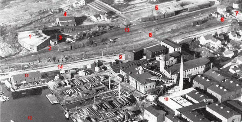
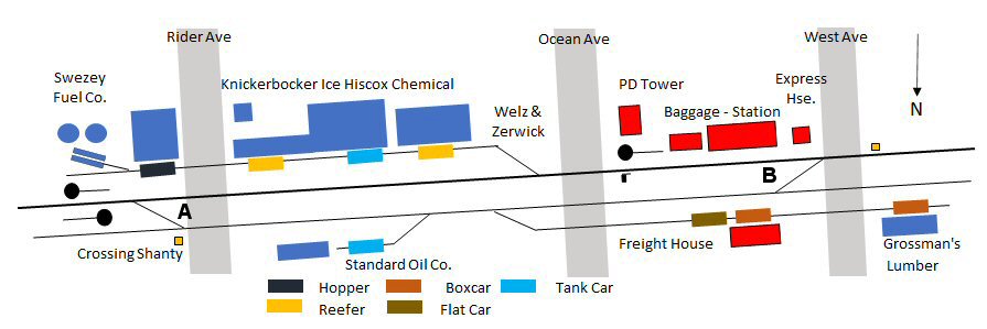
Aerial of the Yard Area c.1920's.
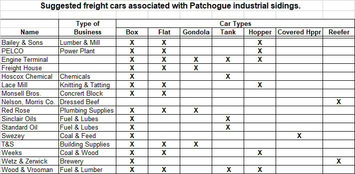
Freight Cars for Patchogue Industries c.1925
1. Four stall Roundhouse Razed: 1928
2. Oil House 3. Armstrong air turntable Razed: 1950 4. Henry
Week's Coal and Wood Yard/Coal trestle Razed: 1952 5. Freight Station
Razed: 5/15/1963
6. Section House/Carpenter's - Hand Car Shed/Yard Office 7. Water
Tower, Railroad Ave. Razed: 1950 8. West Ave. 9. Bailey's 3
Story brick Planning Mill - Built after 1910 10. Bailey's Mill Complex
11. Bailey's Mill Brick/Lime/Lumber Shed 12. Patchogue River 13.
Watchman Crossing Shanty 14. Division Street
 The
structure behind the turntable was identified on Emery's 5/1958 map as the
"Hostler's Cabin" #11 for the obvious reason that there was a hostler there.
I also mentioned that the guy in the late 1940s-early 1950s who was the
hostler was an acquaintance of my father and his last name was Nudo related
to the Nudo Brothers cesspool cleaning company.
The
structure behind the turntable was identified on Emery's 5/1958 map as the
"Hostler's Cabin" #11 for the obvious reason that there was a hostler there.
I also mentioned that the guy in the late 1940s-early 1950s who was the
hostler was an acquaintance of my father and his last name was Nudo related
to the Nudo Brothers cesspool cleaning company.As far as I know, he moved the locomotives and did minor repairs. Anything that he couldn't handle were sent to Morris Park Shops. I have some notes in my
PD Tower orders from 1947 where he notified his bosses that engine #____ needed a ____ replaced and would be towed by the next train west to be dropped off at MPS.
He did not move cars around. That was not a hostler's job. That was a freight engineer's/freight conductor's job when he got to Patchogue. Dave Keller
 First,
the extension east to the connection at Eastport was in the 1870's. Then,
the extension from Bridgehampton to Montauk was in 1895. Trains were running
out there through Patchogue all those years until 1912 when the tower was
built and they didn't seem to have had any issues with their then-in-place
system: Train orders and signals were handled in the ticket office of the
Patchogue station. It was a rather substantial ticket office as I recall it
as a kid, so there was plenty of room for two ticket clerks (there were 2
windows) AND a block operator seated at the bay window.
First,
the extension east to the connection at Eastport was in the 1870's. Then,
the extension from Bridgehampton to Montauk was in 1895. Trains were running
out there through Patchogue all those years until 1912 when the tower was
built and they didn't seem to have had any issues with their then-in-place
system: Train orders and signals were handled in the ticket office of the
Patchogue station. It was a rather substantial ticket office as I recall it
as a kid, so there was plenty of room for two ticket clerks (there were 2
windows) AND a block operator seated at the bay window.
I believe that, had the Suffolk Traction Co. never built a line to the foot
of the Patchogue dock, and crossed the LIRR tracks, there would never have
been a tower built there. We have them to thank. They died in 1919 and the
Tower lived on! Dave Keller
The raze of the entire
yard/coal yards, water columns, freight station, supervisor’s office /shop
and old station occurred on May 23, 1963.
After this date one can model L420s, ALCO FA-1/2 HEP, GP38-2s, passenger ops
(1964 World’s Fair, M1s, etc.), and pre/post MTA paint schemes. Of course
Patchogue has an attractive linear design, waterfront, town close to tracks,
river/woods, etc. for its continued modeling appeal.
Folks model what they know/see (in many cases) thus, the post 1963 era
carries over to the current status: a razed PD Tower, change from PRR
position light signals to the current 3 position color light, and modeling
the reduced MOW storage yard, for example.
 Further on this topic: There are several items of interest to model (in my
opinion) in the more current era: the small foot print waterfront starting
just south across the tracks and Division Street, the LILCO utility
transformer farm that replaced the PELCO facility, the old “Victorian”
housing adjacent the tracks, the current “modern” MOW yard, and modeling a
transition scene showing dual PRR signals/3 position lights under
construction in front of battered PD tower (4/29/2006 for example). These are
mini-scenes to detail that take the viewer in and thus remove the actual
ho-hum of the trackwork. 2022 Steven Lynch
Further on this topic: There are several items of interest to model (in my
opinion) in the more current era: the small foot print waterfront starting
just south across the tracks and Division Street, the LILCO utility
transformer farm that replaced the PELCO facility, the old “Victorian”
housing adjacent the tracks, the current “modern” MOW yard, and modeling a
transition scene showing dual PRR signals/3 position lights under
construction in front of battered PD tower (4/29/2006 for example). These are
mini-scenes to detail that take the viewer in and thus remove the actual
ho-hum of the trackwork. 2022 Steven Lynch