|
|
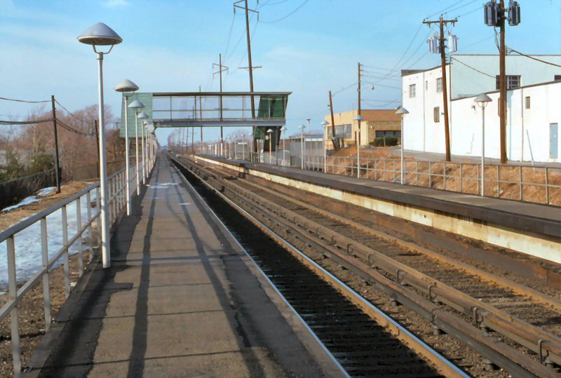
LIRR Stations |
||||||||||||
|
|
 Newsday - "BACK to the FUTURE" Station Renovation 10/27/2017 |
||||||||||||
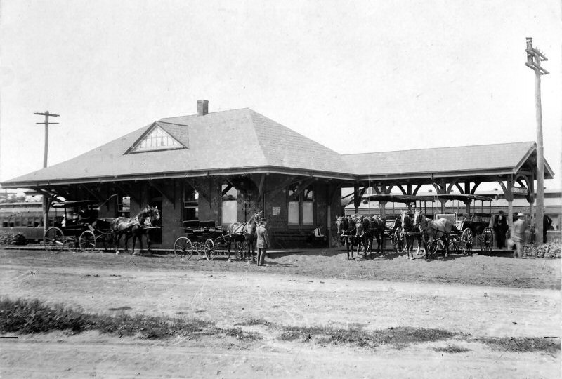
| AMITYVILLE STATION | |||||||||||||
|
|
S. S. R. R. S.SIDE R.R. SVC. BEGAN:
10/28/1867 2ND DEPOT OPENED: 7/25/1889,
RAZED: 5/29/64. REPLACED WITH TEMPORARY STA. BUILDING. IN SVC: 5/29/64. OUT
OF SVC: 10/25/68 ACCOUNT RELOCATION OF TRACKS AND FACILITIES FOR GRADE 2ND TEMPORARY STA. BUILDING
ACCOUNT GRADE CROSSING ELEVATED STRUCTURE IN SVC: 8/7/73 |
||||||||||||
| BABYLON STATION | |||||||||||||
|
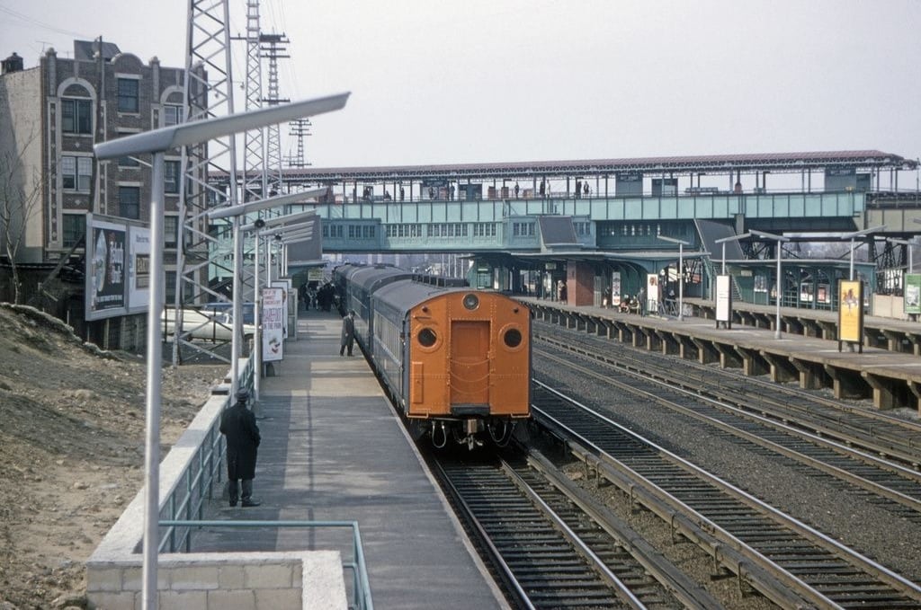
BABYLON SOUTH SIDE R.R. BEGAN SVC: 10/28/67 DEPOT OPENED. 2ND DEPOT OPENED: 7/2/1881, RAZED: 1963 WITH GRADE CROSSING ELIMINATION. TEMPORARY STATION ACCOUNT GRADE CROSSING ELIMINATION IN SVC: 4/6/63. OUT OF SVC: 9/9/64 AND RAZED. ELEVATED STRUCTURE IN SVC: 9/9/64. |
|||||||||||||
 Babylon Station View E c. Winter 1960 Archive: Jim Gillin |
 Babylon Station temp 09/1964 Archive: Dave Keller |
 Babylon Station temp and new 09/1964 Archive: Dave Keller |
|||||||||||
|
Two shots of the
temporary station platforms at Babylon
with new, elevated tracks/station in background, shot in 1964. Note
that the temporary station platform shelters are on the exact site of the
old depot building as the tracks ran south of the original ROW and right
through the site. In the background of the shot showing the shelters
close-up you can see “ |
|||||||||||||
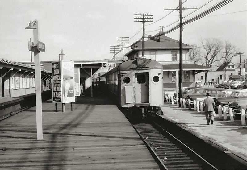
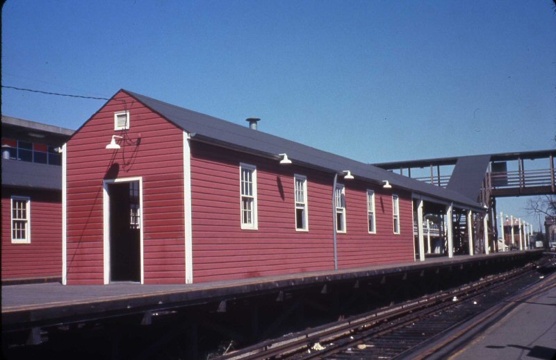
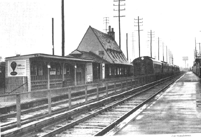
| BALDWIN STATION | |||||||||||||
|
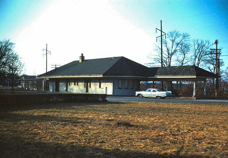
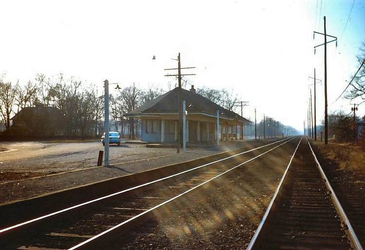
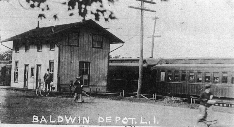
BALDWIN SOUTH SIDE R.R. SVC. BEGAN: (MONTAUK) 10/28/1867 AS BALDWINSVILLE.” DEPOT BUILT: 2/1868. REMODELED: 5/1881. RAZED 1917. 2ND DEPOT BUILT: 12/28/17, RAZED: 11/56 WITH GRADE ELIMINATION. ELEVATED STRUCTURE OPENED: 10/2/57 |
|||||||||||||
|
This view is of the original depot, the line double tracked, but not electrified, the image would have been shot between June 1891 (double-tracking) and the end of December, 1917 (depot replacement). Research: Dave Keller
|
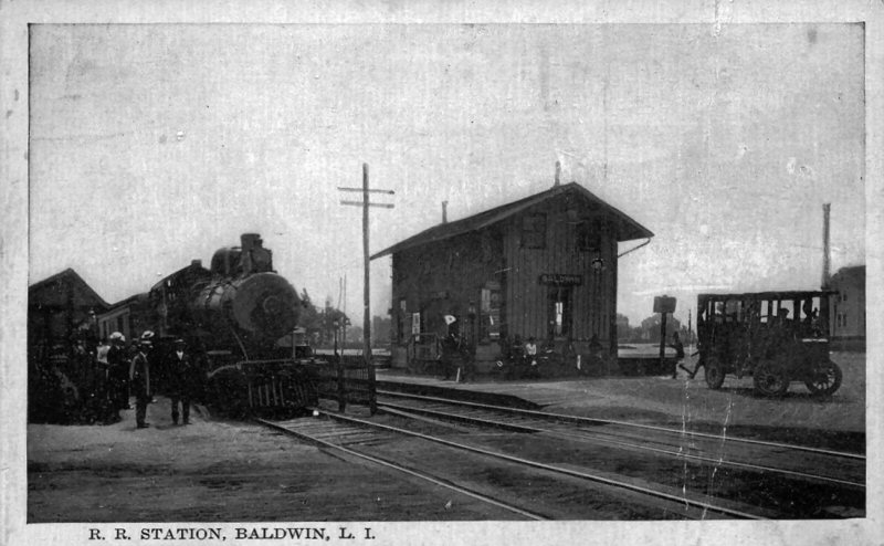
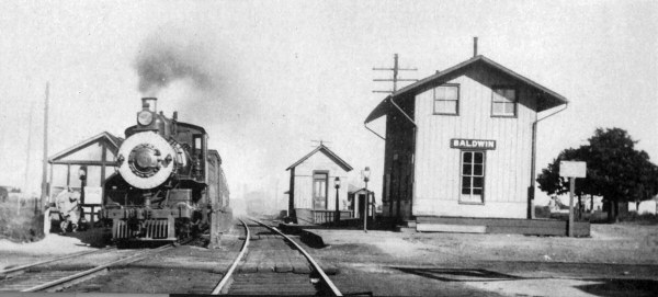 Baldwin Station view E c.1910 The freight house is the larger structure
east of the depot. The express house is the structure closer to the depot.
|
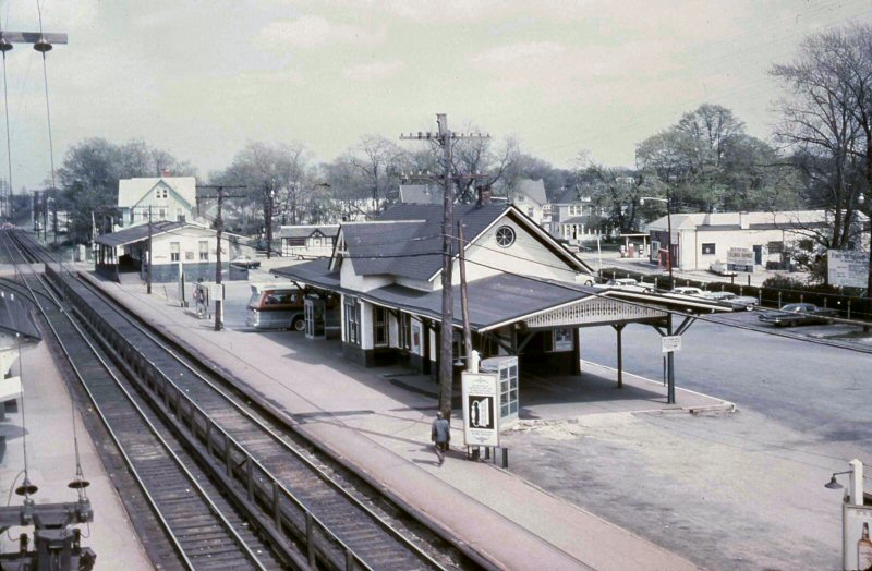
 Baldwin Station View W Temporary tracks running behind the depot rear view 5 roof windows on the station parking lot side Research: Dave Keller Photo: Jim Shaughnessy Archive: Tim Darnell
|
|||||||||||
|
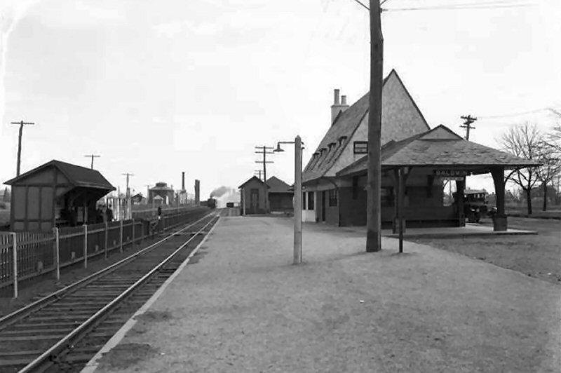
The second Baldwin station was on the south side of the tracks; the same location as the original South Side RR station. The replacement station shown in the above right postcard was opened on 12/28/1917. Also note the same express and freight houses that appear in the c. 1906 shot above are still standing in this later image. It appears they simply razed the old SSRR depot and replaced it with the newer structure in nearly the same spot. The westbound express house at the far left is an open structure. Most of these were closed in by the 1930s, not only for the weather, but for security. Also, electrification came through the south shore and reached Babylon in 1925. You
can see in the middle shot showing the temporary tracks that they are running past the
station side with the 5 roof windows, while the older view, with the tracks
in front of the bldg are running past 4 windows! Therefore,
newer photo is actually looking at the REAR of the depot. Due to the
space restrictions on site, the temporary tracks were run BEHIND the depot. Research: Dave Keller, LIRR Historian |
|||||||||||||
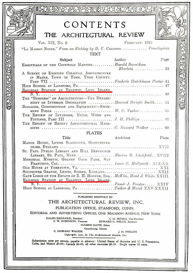 |
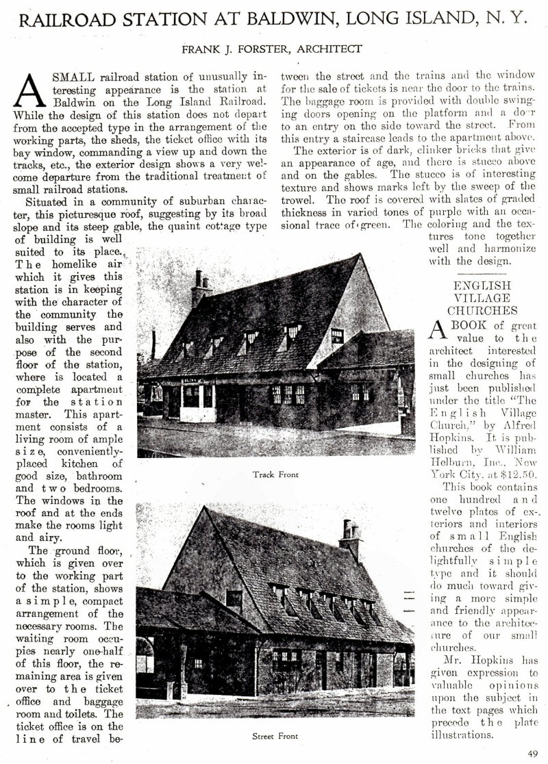
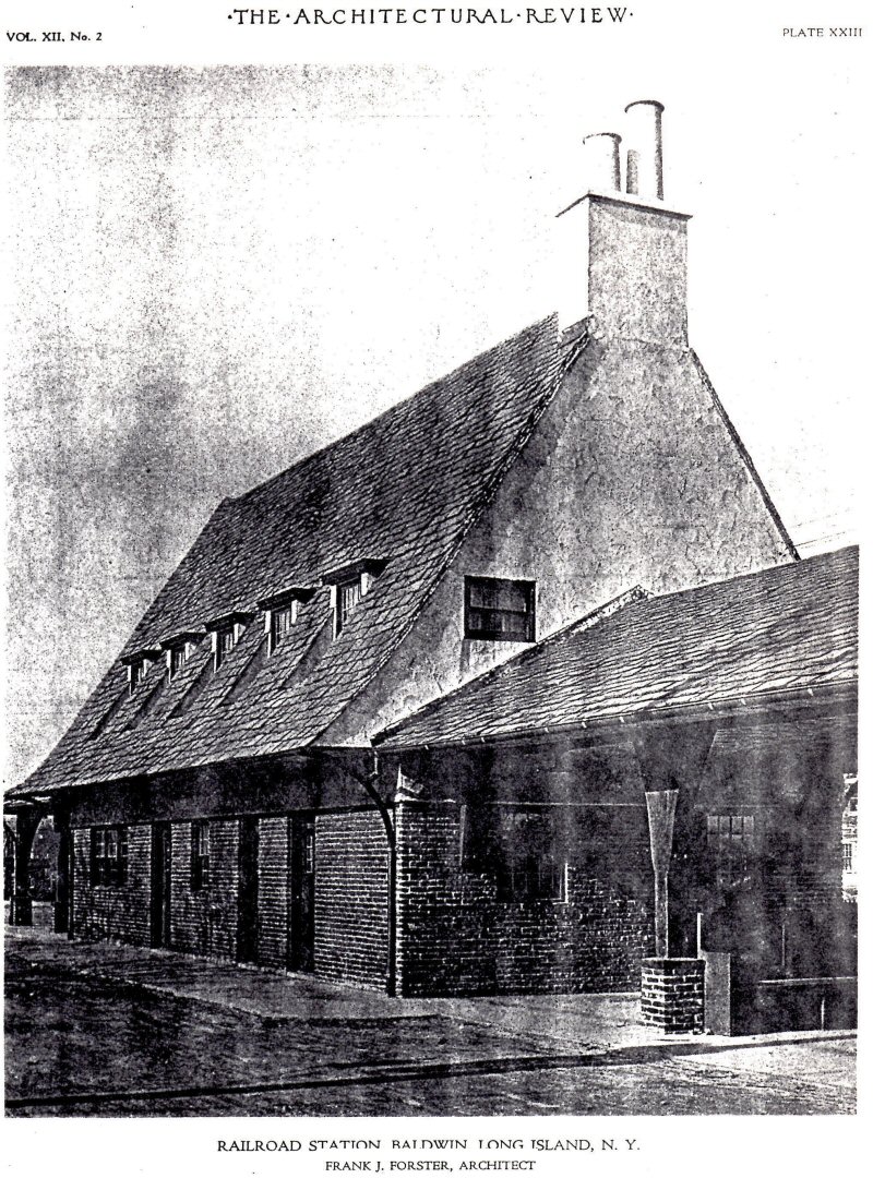 Architectural Review February 1921 - Baldwin Station Archive: Gary Farkash |
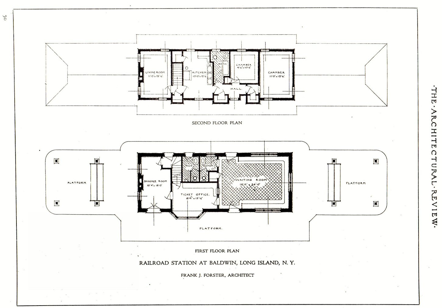 Baldwin Station Floor Plan Architectural Review February 1921 Frank J. Forster, Architect |
|||||||||||
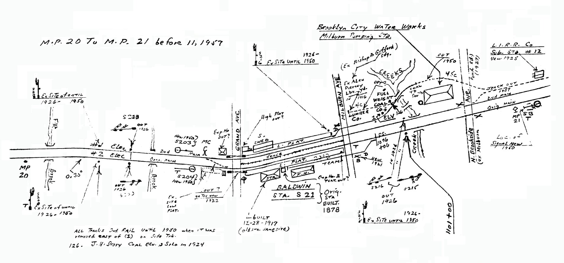 Emery map Baldwin MP20-21 before 11/1957 Archive: Dave Keller |
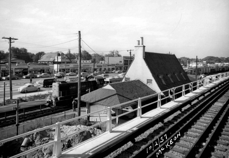 Baldwin Station - Grade Elimination with a freight on the Shoo Fly - View SW 10/02/1957 Photo/Archive: Gary Farkash |
||||||||||||
| BAYPORT STATION | |||||||||||||
|
SOUTH SIDE R.R. DEPOT BUILT:
3/1869, RAZED: 1903 STATION STOP PER G.O. #207, EFF: 9/6/80. |
|||||||||||||
 Bayport Station view NW Railroad St. 10/1962 Photo/Archive: Brad Phillips |
 Bayport Station Snedecor Ave view W 10/1962 Photo/Archive: Brad Phillips |
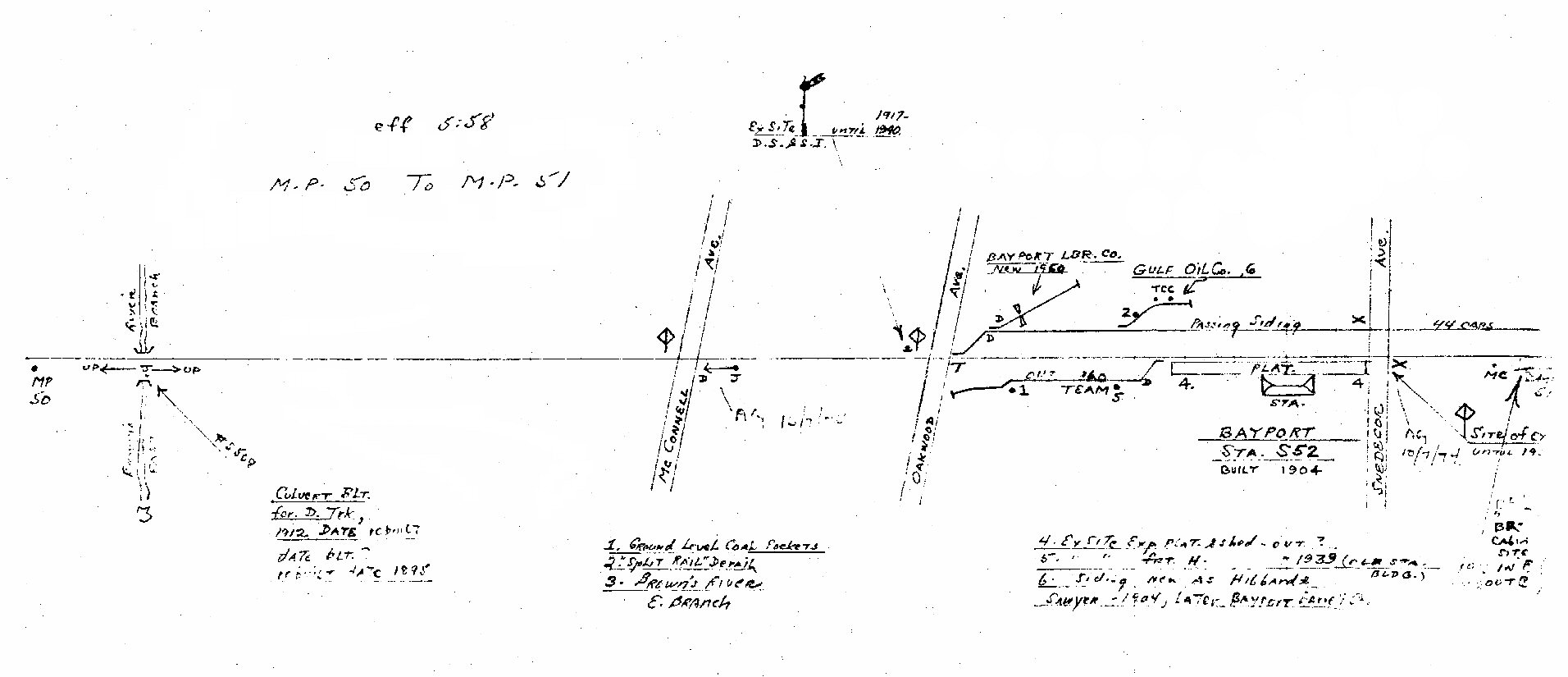 Emery map Bayport 05/1958 MP50-51 |
|||||||||||
| BELLAIRE STATION | |||||||||||||
|
BELLAIRE MAIN LINE OPENED: 3/20/1900 AS “INTERSTATE PARK.” RENAMED “BELLAIRE” IN 1907. 2ND DEPOT OPENED: 9/20/1924 (per official dedication invitation), DISCONTINUED AS STATION STOP: 1972, RAZED: 19 ? Research: Dave Keller |
|||||||||||||
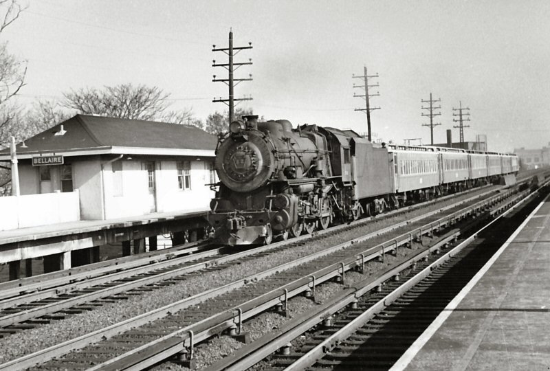 LIRR #32 G-5 WB at Bellaire c.1953 Archive: Jim Gillin 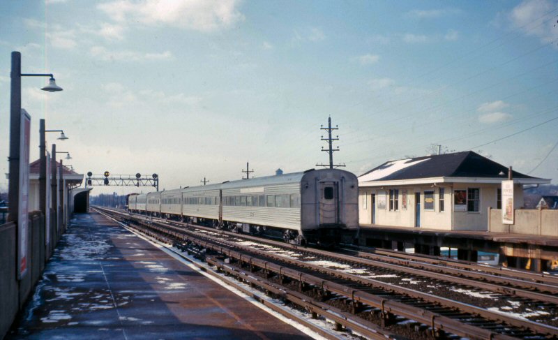 Silver Streak ex-NYC cars WB 12/02/1967 Archive: Dave Keller |
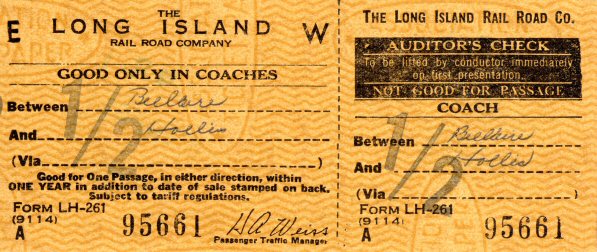
Note: Validated at Bellaire as a “blank to blank” form to be handwritten. The station to blank stock form was only ordered by stations having lots of sales to stations not justifying printed stock. Small, rush hour only stations like Bellaire had only full open stock as not many people purchased tickets to ride such a short distance, not justifying printed stock. Brad Phillips |
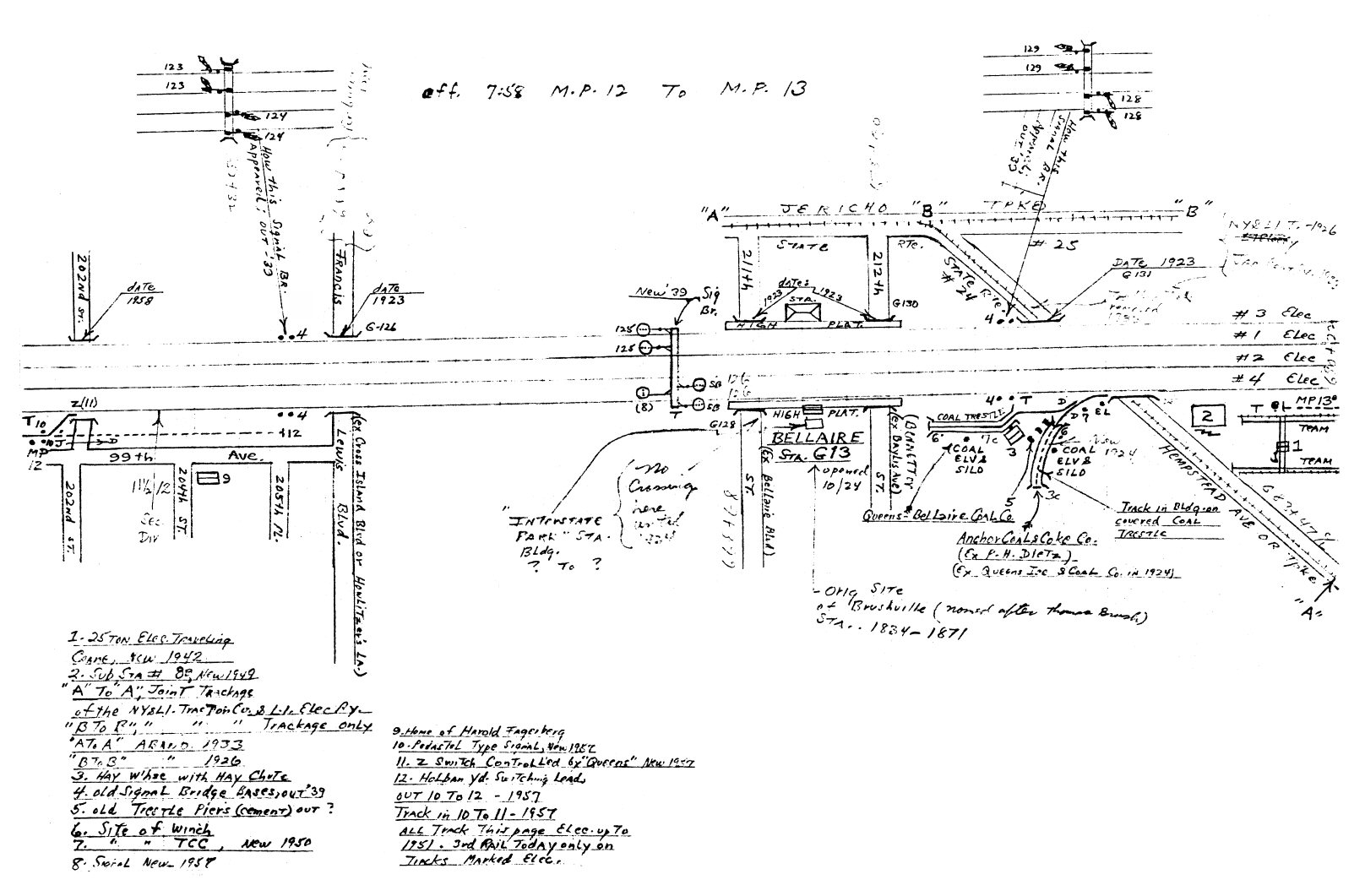 Emery map - Bellaire MP12-13 7/1958 Archive: Dave Keller
|
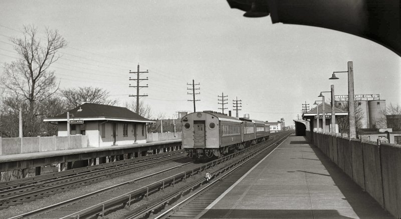 MU train on express track passing through Bellaire 1956 W. J. Broschart photo, Dave Keller archive Note: Although located physically on the Main Line, Bellaire and Hollis were actually stops on the Hempstead branch. The MU train in the image is eastbound on the Main Line tracks. Had it been a Hempstead train it would have been running on the outer, "platformed" tracks. Research: Dave Keller |
||||||||||
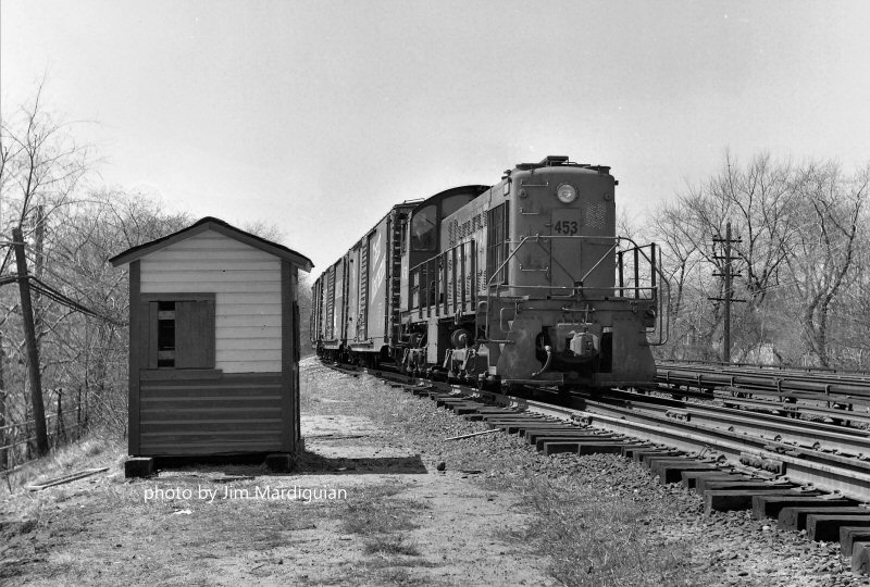 S2 #453 freight view W at the telephone shanty - 1968 Photo/Archive: Jim Mardiguian |
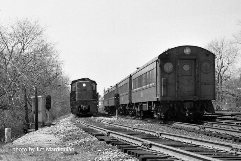 S2 #453 freight on the Hollis Lead waits for the Hempstead local to pass, then gets signal to proceed at the low pedestal signals. Emery map location #10 above View W 1968 Jim Mardiguian |
||||||||||||
|
The present-day (since about 1950) Hollis Lead extends east from Holban Yard parallel to main track 4, behind the e/b platform at Hollis and runs maybe a quarter mile to what's listed in the ETT as "Hollis" interlocking, controlled from Queens (at the time). After Hollis tower and interlocking near the passenger station was removed around 1951 or so, Track 4 was made reversible between the new Hollis Interlocking (controlled by Queens) and Queens interlocking. Outbound freights would pull down to the shanty depicted, probably nothing more than a block phone booth, and would let Queens know they were ready to depart east (and likely give crew, engine number, consist, etc). Westbound freights for Holban would cross over to track 4 at Queens and run to Hollis and down the lead. Research: Jim Mardiguian |
|||||||||||||
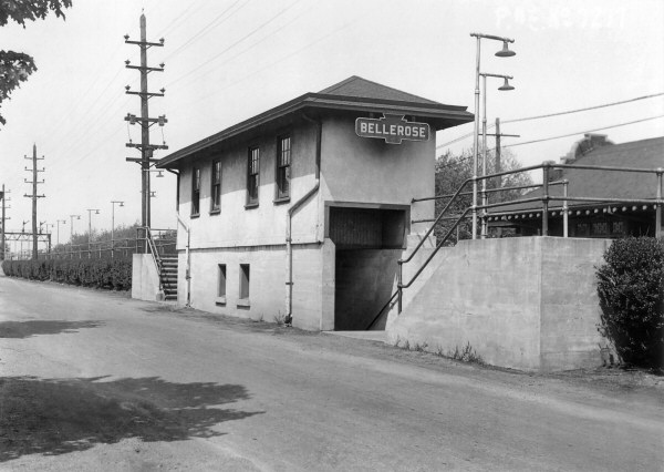
| BELLEROSE STATION | |||||||||||||
|
Opened: 1898
2nd Depot built: Summer/1909, Out of service: 12/12-15/1960 |
|||||||||||||
 Bellerose Station - View NW c.1919 Archive: Dave Keller
|
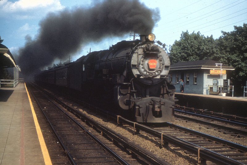 K4s #5406 passing Bellerose Station View E c.1950 Archive: Richard Glueck
|
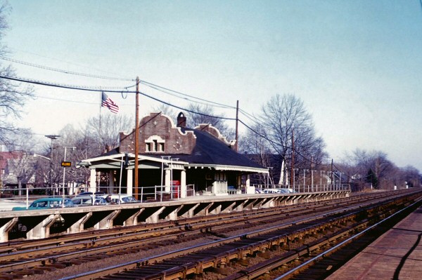 Bellerose Station view SE 1960 Archive: Art Huneke
|
|||||||||||
| BELLPORT | |||||||||||||
 Bellport Station view SE 1962 Archive: Art Huneke |
BUILT:
SUMMER/1882, |
||||||||||||
.jpg) G54sa Camelback #19 with fireman on Bellport passing siding view SE c.1915 (Holman-Keller) Welz & Zerwick Beer Distributor at left |
 Bellport Station View SW 3/1959 Photo: Robert Emery Collection: SUNY Stony Brook |
.jpg) Bellport Station View E c. 1925 (Osborne-Keller) |
|||||||||||
| BLUE POINT | |||||||||||||
 Blue Point LIRR RS3 #1555 view NE 12/02/1962 Photo: Brad Phillips |
 Blue Point view E 12/02/1962 Photo: Brad Phillips |
S.S.R.R. depot opened:
2/1/1870, closed: 6/1/1882 |
|||||||||||
| BRIDGEHAMPTON | |||||||||||||
 Bridgehampton Station 1958 Photo: LIRR Archive: Jim Gillin |
OPENED: 6/1870, BURNED:
7/6/1884 2ND DEPOT BUILT: 1884,
|
||||||||||||
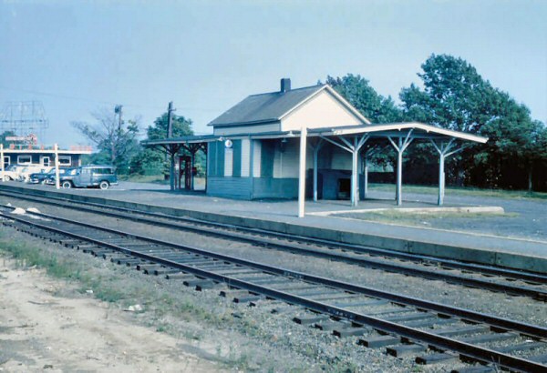
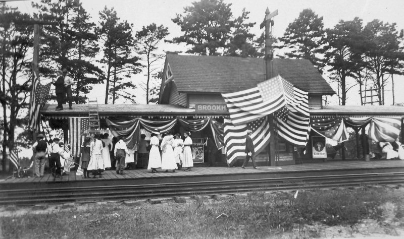
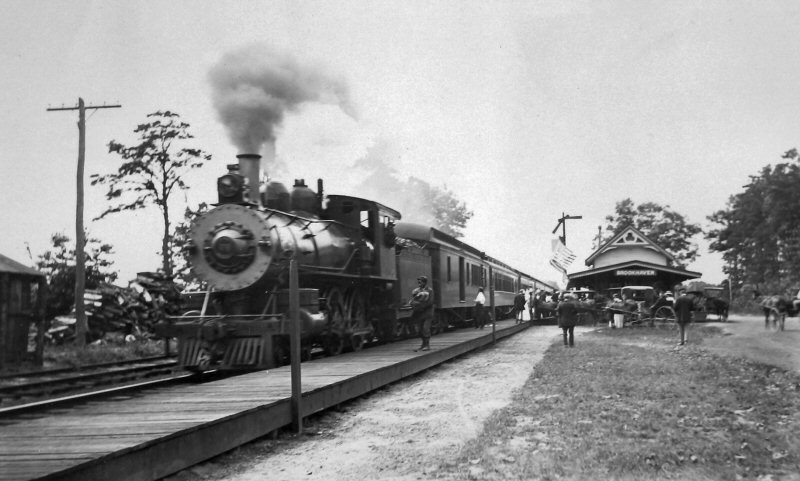
| BROOKHAVEN | |||||||||||||
|
BUILT: 1884. BECAME ONLY A SIGNAL STOP THROUGHOUT THE 1880s AND 1890s. IN LATER YEARS, THE TICKET OFFICE HOUSED "VN" BLOCK STATION UNTIL TAKEN OUT OF SERVICE AND REPLACED WITH UNATTENDED BLOCK STATION SIGNALS IN 1927. AGENCY CLOSED: 1932. DEPOT REMODELED: 1944, REMOVING COVERED PLATFORMS. CLOSED AND DISCONTINUED AS STATION STOP: 10/6/58. BUILDING SOLD AND RELOCATED TO PRIVATE LOCATION: c. 1958-59 |
|||||||||||||
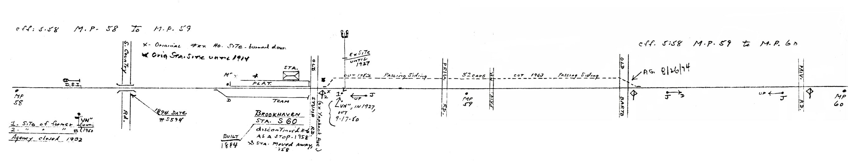 Emery map - Brookhaven MP58-60 5/1958 Archive: Dave Keller |
|||||||||||||
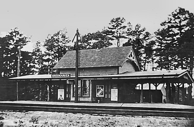 Brookhaven Station - View NW c.1890 |
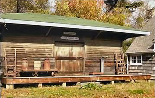 Brookhaven Freight House |
||||||||||||
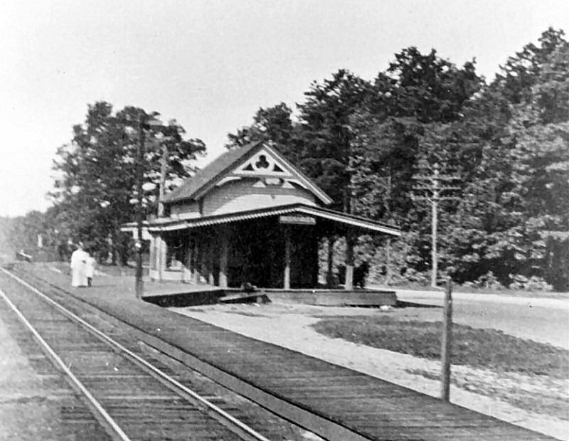 Brookhaven Station c.1910 |
|
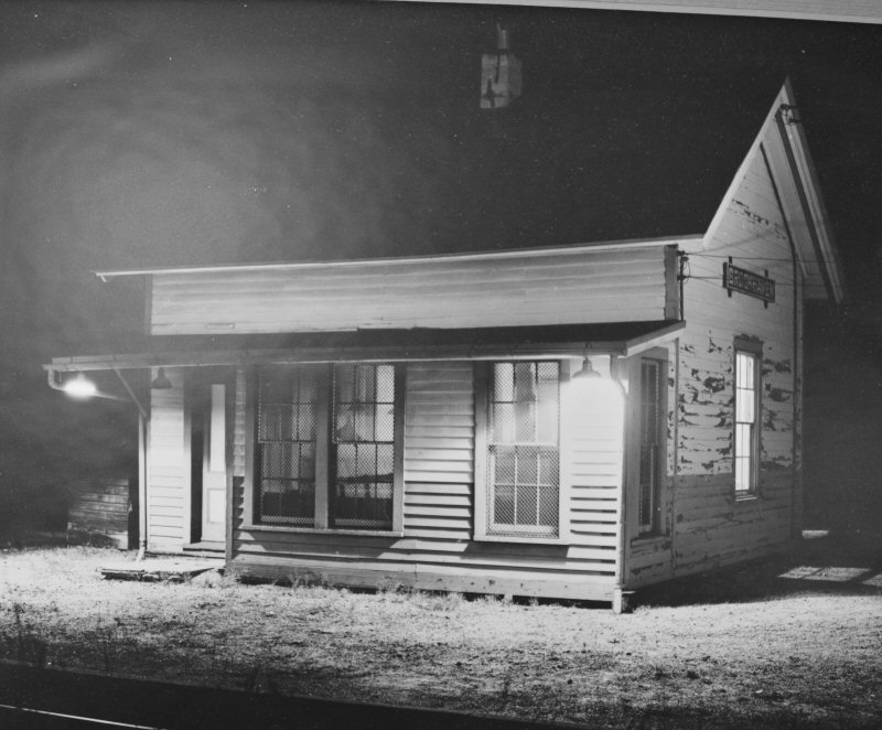 Brookhaven Station 1953 - Renovation of the covered platforms removed in 1944 Photo: Wetterau/Viken Archive: Patchogue Public Library |
|||||||||||
| CALVERTON | |||||||||||||
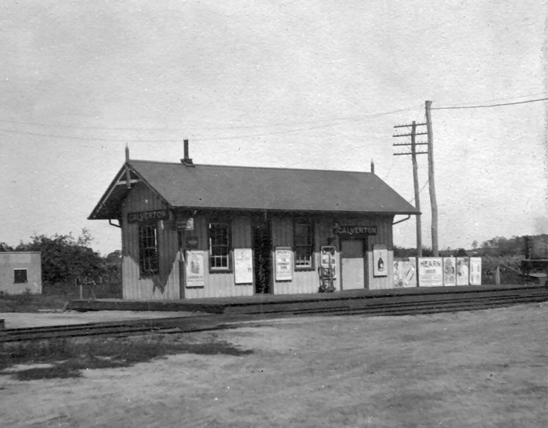 Calverton station when it was west of the Edwards Ave. crossing and on the north side of the tracks. It was sold in 1922 when the replacement depot was opened on the south side of the tracks and east of Edward’s Ave. View NE c.1915 Had this depot still be in use in August, 1926, I believe it would have been wiped out in the Pickle Work’s wreck, due to its proximity to the pickle works and the way the locomotives and cars spun around. Archive/Research: Dave Keller |
DEPOT BUILT: 1880 AS “BAITING HOLLOW”,
CLOSED 2ND
DEPOT BUILT FURTHER EAST: 1922.
AGENCY CLOSED: 1958 LAST LISTED IN ETT #4, EFF: 5/85 BUT
WITH NO TRAINS
|
||||||||||||
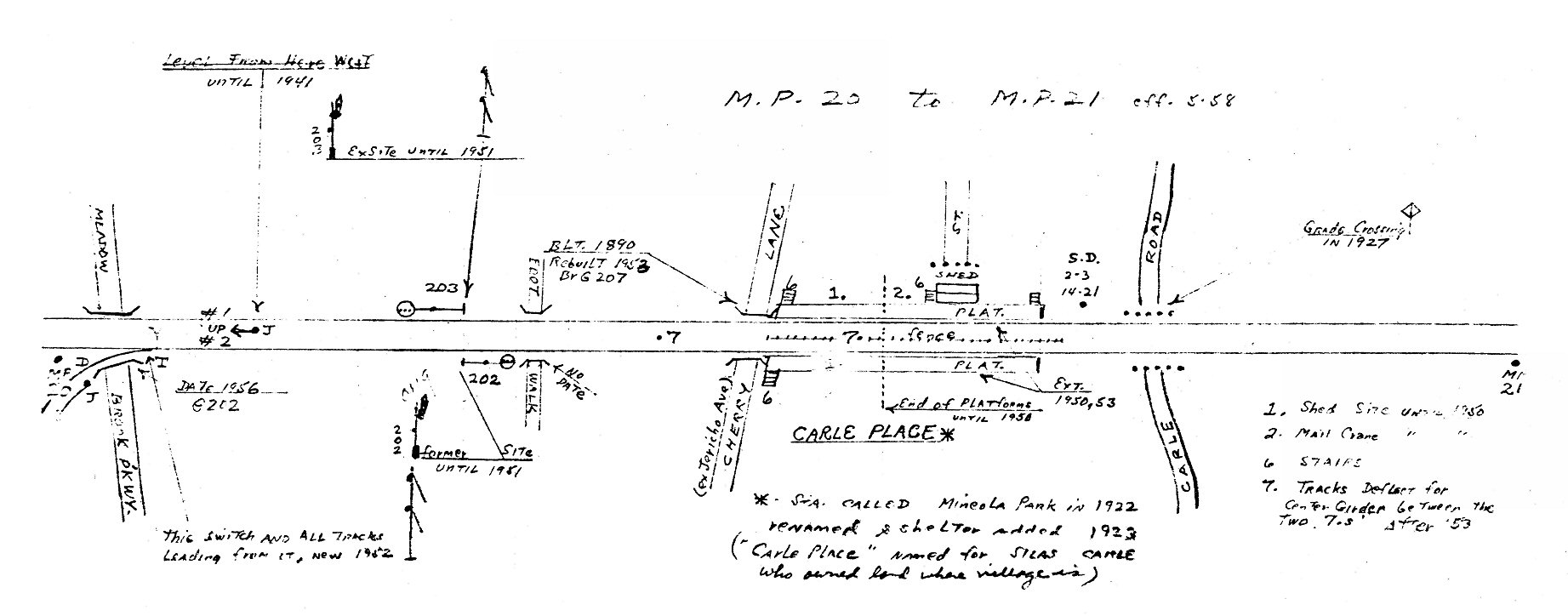
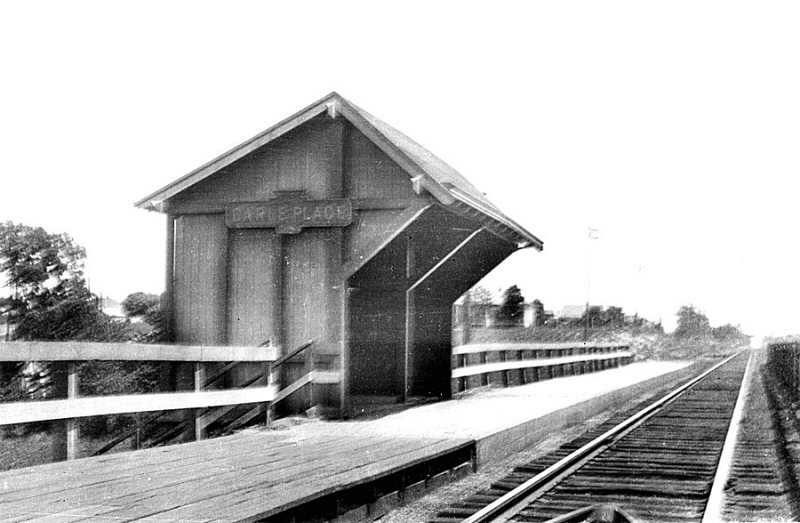
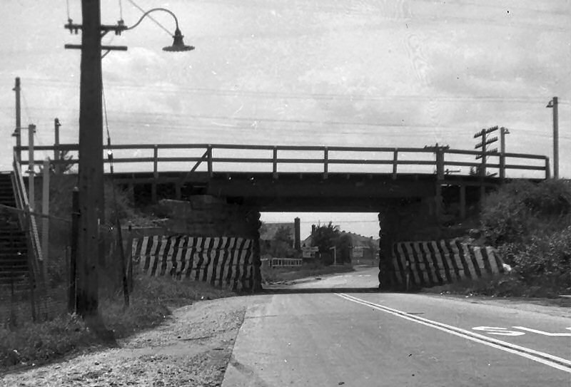
| CARLE PLACE STATION | |||||||||||||
|
DEPOT BUILT: 1837 WITH OPENING OF LIRR TO HICKSVILLE. APPEARS ON TIMETABLE OF 6/17/1837. REMOVED AS STATION STOP
FROM TIMETABLE OF 1859. |
|||||||||||||
|
Note: Overpass of Ellison Avenue with semaphore signals mounted thereon, on the east side of MP21, just west of Westbury, in background. Info: Dave Keller |
|
|
 Carle Place Station Archive: Ray Muntz
Consist: 9033-9034+9003-9004+9009-9010 |
||||||||||
| CEDARHURST STATION | |||||||||||||
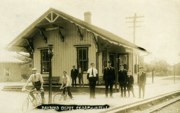
Cedarhurst c.1900 view SW 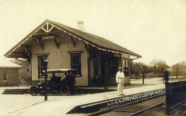 Cedarhurst c.1910 view SW |
S.SIDE R.R. BEGAN SVC: 7/1869. |
||||||||||||
| CENTER MORICHES | |||||||||||||
|
BUILT: 1881. MORICHES CHAMBER OF COMMERCE PETITIONED THE LIRR IN FEBRUARY, 1943, TO CHANGE THE SPELLING OF THE STATION STOP TO "CENTER" IN LIEU OF "CENTRE." (Derek Stadler data). AGENCY STILL LISTED IN "L.I.R.R. TICKET OFFICES OPEN FOR SALE OF TICKETS" OF 9/12/55. RAZED: 5/64. REPLACED WITH METAL SHELTER SHED. NEWER WOODEN SHELTER BUILT: c. 1985. DISCONTINUED AS STATION STOP: 3/16/98 |
|||||||||||||
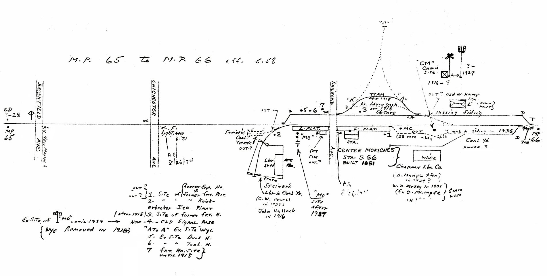 Emery map Center Moriches MP65-66 5/1958
|
.jpg) Center Moriches Station c.1918 |
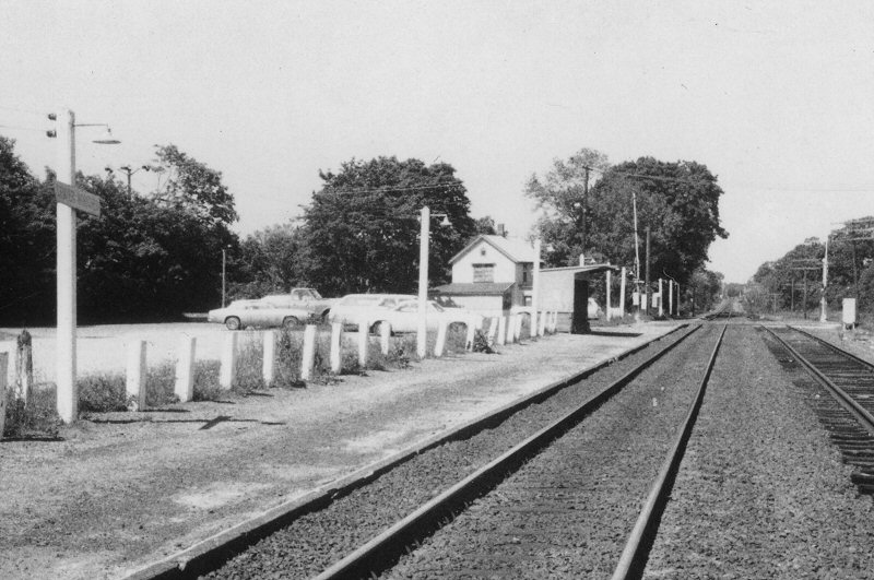
.jpg) Center Moriches Station View SE 10/17/1952 (Viken-Wetterau-Keller) |
|||||||||||
.jpg) Center Moriches Station View SE 1963 (Emery-Keller) |
 Center Moriches metal shelter shed - View W 6/15/1978 Archive: Dave Morrison |
.jpg) Center Moriches Station View SE (above) 12/1985 (Keller-Keller) %20(Hi%20Res).jpg) |
|||||||||||
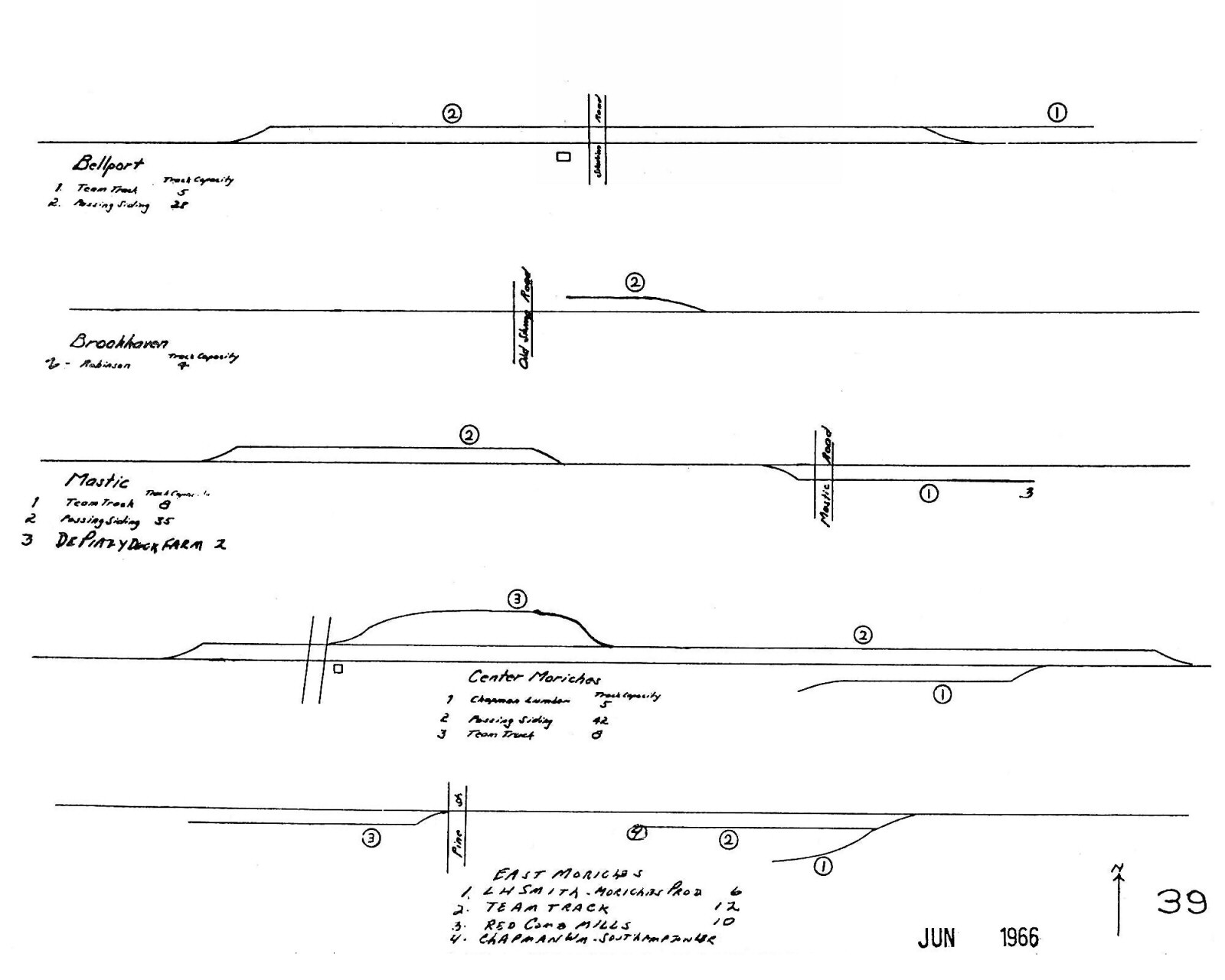 LIRR 1966 map Center Moriches |
.jpg) Signal MO - Center Moriches view W from end of station platform 4/1970 (Keller-Keller) |
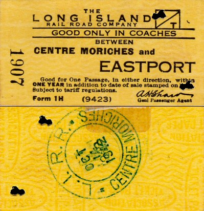 Ticket Centre Moriches - Eastport 10/14/1942 Archive: Brad Phillips |
|||||||||||
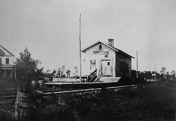
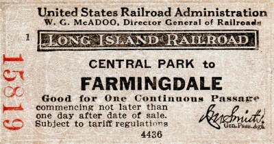
| CENTRAL PARK STATION | |||||||||||||
|
|
Originally opened as “Jerusalem” c.1854. Station stop located one mile west of Bethpage Jct. Does not appear on LIRR timetables between 1842 and 1855, however it does appear in an April, 1854 LIRR advertisement in the “New York Times.” The Post Office changed name of the town to Central Park in 1867 as it was located midway between Hyde Park (later New Hyde Park) and Deer Park. The name of Station stop varies as follows: Map of 1873 =
Jerusalem timetable of 1877 = Central Park 2nd Depot built:
1884, Renamed “Bethpage”: 10/1/36. Razed: 1959 |
||||||||||||
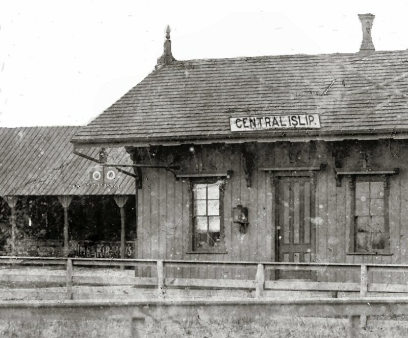
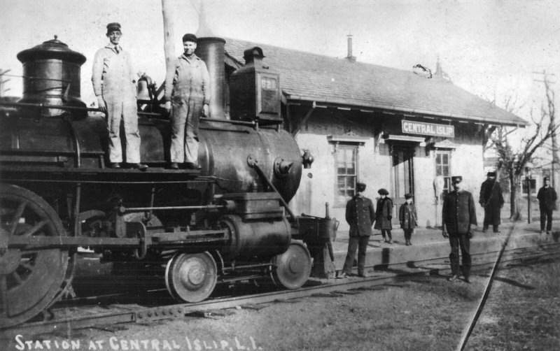
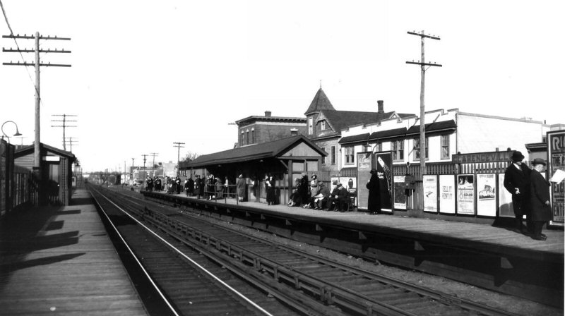
| CENTRAL ISLIP STATION | |||||||||||||
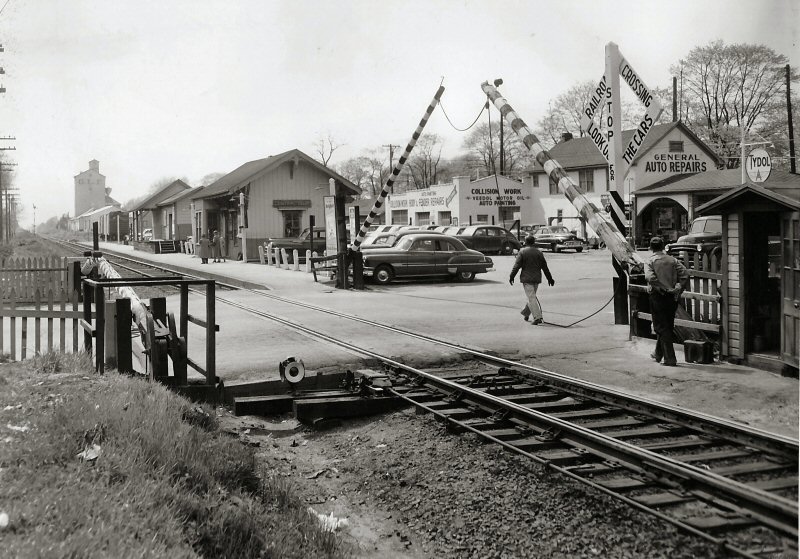 Central Islip Station 05/1954 view West Archive: Jim Gillin |
OPENED: 11/4/1873 TO REPLACE “SUFFOLK”
STATION FURTHER WEST. REMODELED c. 1916, RAZED: 8/58 3RD DEPOT RELOCATED 1,700’ EAST OF FORMER LOCATION ON SOUTH SIDE OF MAIN TRACK WITH HIGH LEVEL PLATFORMS IN SVC: 11/16/87. FACILITIES ON NORTH SIDE OF PASSING SIDING IN SVC: 12/14/87
|
||||||||||||
 Central Islip Station c.1885 Train Order Signal Archive: Dave Keller |
 Central Islip Station - Agent Frank Kelly c.1910 Train Order Signal has been removed. Archive: Dave Keller |
 LIRR #521 crew at Central Islip Station c.1950 Archive: Art Huneke |
|||||||||||
| CLARENCEVILLE STATION | |||||||||||||
 Clarenceville Station c.1925 Archive: Art Huneke |
CLARENCEVILLE - ATLANTIC BRANCH BUILT: 1905 (?) WITH ELECTRIFICATION FROM FLATBUSH AVE. OUT OF SVC: 11/1/39 PER G.O. #1204 AND RAZED WITH ATLANTIC AVENUE IMPROVEMENT PROJECT: 1939-40 |
||||||||||||
| COLLEGE POINT STATION | |||||||||||||
|
|
OPENED: FLUSHING R.R. 8/14/1869, followed by NY & FLUSHING, FLUSHING & N. SIDE, as WHITESTONE BRANCH CLOSED: 2/19/32 WITH LINE ABANDONMENT, RAZED: 9/19/34 |
||||||||||||
|
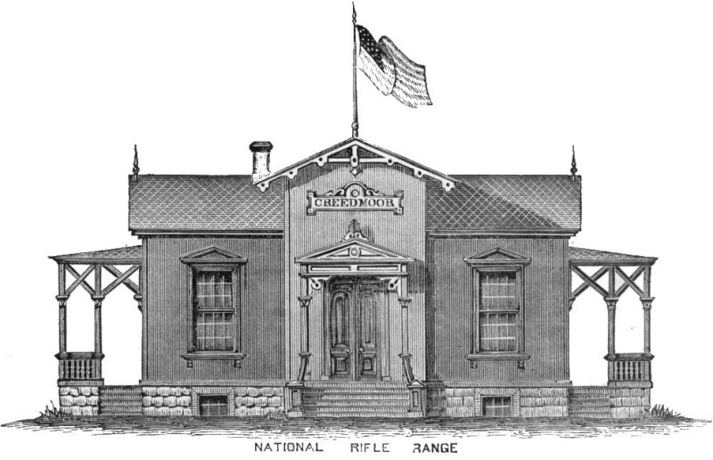
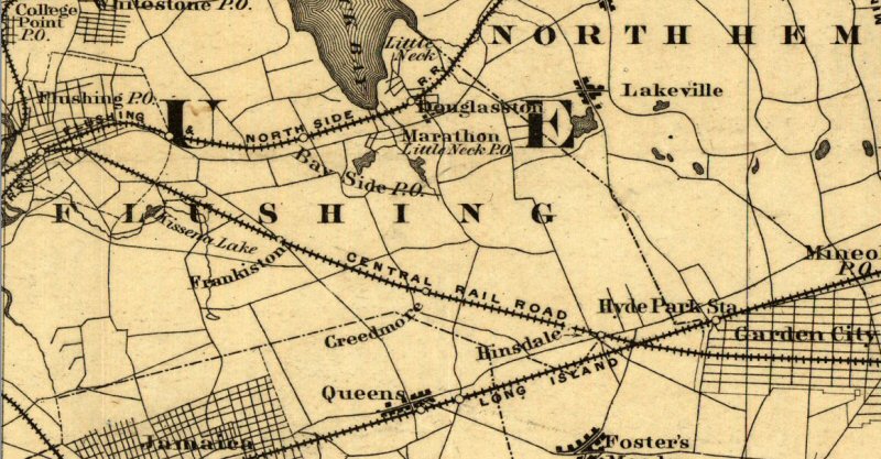
CREEDMOOR STATION
OPENED:
1/8/1873, TO SERVICE THE RECENTLY FORMED (1871) NATIONAL RIFLE ASSN.'S
(NRA) NEWLY OPENED NATIONAL RIFLE RANGE BUILT, IN CONJUNCTION WITH N.Y.
STATE LEGISLATURE AND THE N.R.A., ON 70 ACRES OF LAND ACQUIRED FROM A MR.
CREED. 1ST INTERNATIONAL MATCH HELD AT RANGE: 1874. BRANCH AND
PASSENGER SERVICE ABANDONED BY CRR OF LI: 4/30/1879. USED BY LIRR
UNTIL 1881 TO CONTINUE TO SERVICE THE RIFLE RANGE VIA LIRR'S MAIN LINE
AND "CREEDMOOR CUT-OFF" WEST OF |
|||||||||||||
Creedmoor Station National Rifle Range - 1870s
|
|
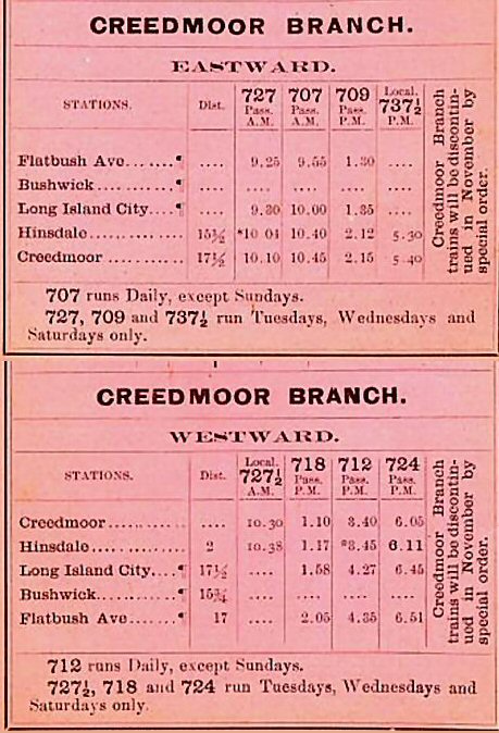 LIRR Creedmoor Branch Timetable 1879 |
|||||||||||
|
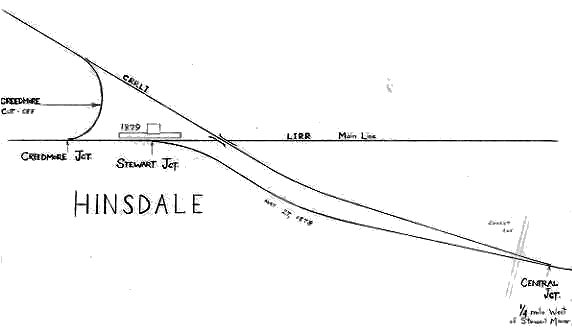
Travel to Creedmoor Station was originally via CRR of LI from Flushing Central Jct. Originally there was no connection with the LIRR's Main Line. CRR bridged the Main Line and headed towards Garden City and Hempstead. After LIRR takeover, the bridge was removed and the Creedmoor cutoff installed. Also, access to what became the LIRR's Hempstead branch was installed and an interlocking tower placed in service to control this junction. The junction was eventually removed at Flushing, the CRR of LI's trackage became the LIRR's North Side Division (Later Port Wash branch) and the tracks removed from there to Creedmoor in the teens. Under LIRR control, LIRR trains operated via the Creedmoor Cutoff at what later became Floral Park on the LIRR's Main Line, until the LIRR ended passenger service to Creedmoor in 1881. Rail service was freight-only after that, accessed from east of Floral Park Station, once the Creedmoor Cutoff was removed. At the time of this timetable, September, 1879 (above right), trains were run via the LIRR, eastbound thru Stewart Jct., using the "Creedmoor Cutoff" installed in 1878 west of the station, accessing East Hinsdale and terminating at Creedmoor for the National Rifle Range. You'll notice that the other stations that were on that branch (Flushing/Central Junction, Kissena Park, and Frankiston are not even listed. Those stops had already been abandoned to passenger service in April 30, 1879. Research: Dave Keller |
|||||||||||||
| EASTPORT STATION | |||||||||||||
 Eastport Station 1962 Photo/Archive: Art Huneke |
BUILT: 3/1870 AS “MORICHES”
STATION ON ORIGINAL SAG |
||||||||||||
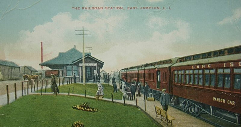
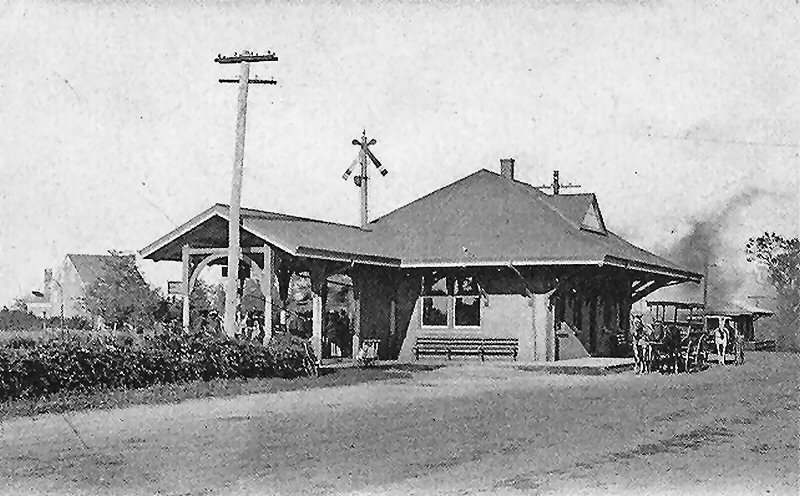
| EAST HAMPTON STATION | |||||||||||||
|
BUILT: 1895. FULL-TIME AGENCY CLOSED: ? SUNDAY AGENCY ONLY: 2005 Research: Dave Keller |
|||||||||||||
 Emery map East Hampton MP100-101 - 7/1958 Archive: Dave Keller |
|
||||||||||||
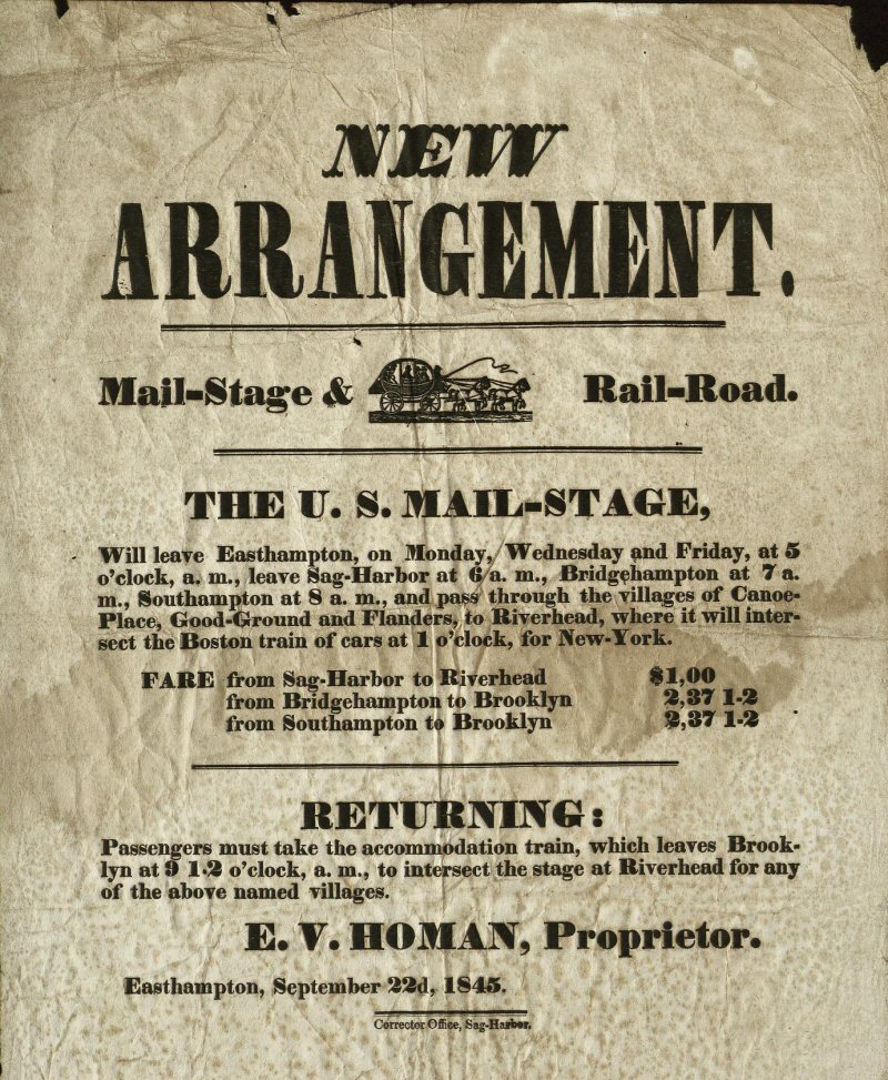 9/22/1845 broadside (poster) to advertise US Mail via stage delivery to LIRR connection at Riverhead. Newspaper: Sag Harbor Corrector Archive: East Hampton Historical Society |
Easthampton prior to name change: East Hampton was first called Maidstone, after Maidstone, Kent, England. The name was later changed to "Easthampton", reflecting the geographic names of its neighbors, Southampton and Westhampton. In 1885 the name was split into two words, after the local newspaper the East Hampton Star began using the two-word name. "Maidstone" is frequently used in place names throughout the town, including the Maidstone Golf Club. Wiki East Hampton to Sag
Harbor 7 miles - Horses at a trot can cover this distance within the hour. Interesting also, is the fare structure. Sag-Harbor to Riverhead $1.00 The Bridgehampton to Brooklyn $2.37 and ˝ cent (left). Worth about $72.00 inflation adjusted today. (Such a deal!) That fare was quite steep for the day. Infantrymen in the Mexican-American war 1846-48 earned $7 per month, for example. Really a fortune back then, as only the wealthy could afford this form of travel. |
|
|||||||||||
|
|
|||||||||||||
 East Hampton view W - 1/1975 Photo/Archive: Jim Gillin
|
 East Hampton (HA) MP 100 - Prior/Current 2024 Design/Archive: Joe Vila |
 East Hampton view E - 8/1975 Photo/Archive: Jim Gillin
|
|||||||||||
|
Until
recent years, there was a porcelain sign on the rear exterior wall of the
depot building that read “Carriages must not stand at this platform except
while actually discharging or loading passengers.” Its since disappeared
from the wall. The freight station was moved to a private location at one of the three LIRR
trestles east of the station and was visible, if one looked specifically for
it, while crossing over the street via said bridge while in an eastbound
train, and looking south. I cannot recall the name of the street in
question, but there were three bridged roads east of the station. Info: Dave Keller |
|||||||||||||
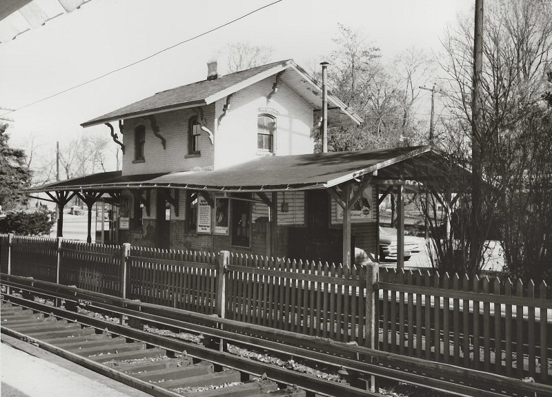
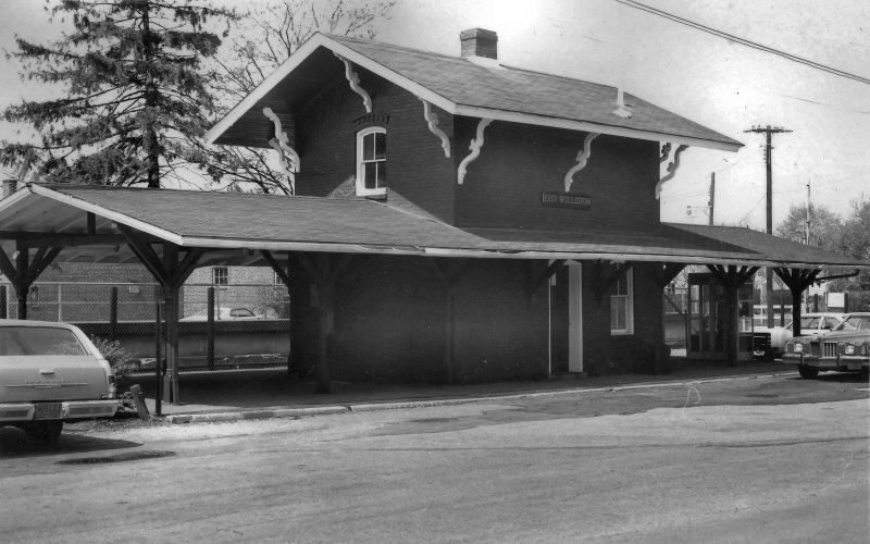
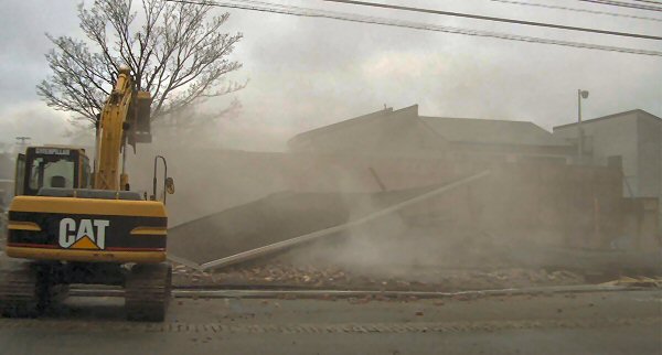
| EAST WILLISTON STATION | |||||||||||||
|
EAST WILLISTON OYSTER BAY BRANCH BUILT: c. 1880. AGENCY CLOSED: 12/10/96. RAZED: 12/11/2004 |
|||||||||||||
|
|
|
|
|||||||||||
|
FLORAL PARK STATION |
|||||||||||||
|
|
BUILT: OCT-NOV/1878 AS “STEWART JUNCTION.” RENAMED HINSDALE: 1879 WITH CLOSING OF CRR OF LI DEPOT. Note:
Keystone station sign on the depot. “PARK” tower in the rear right
background behind the man and crossing shanty at the end of the station
platform on the other side of |
||||||||||||
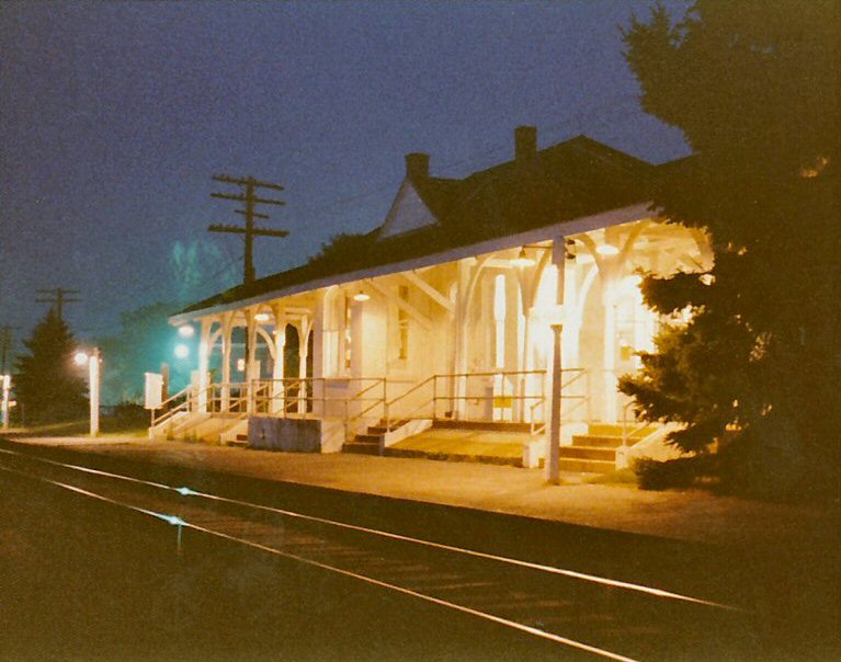
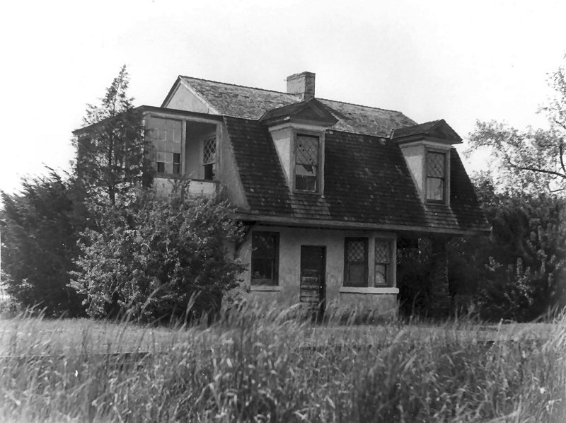
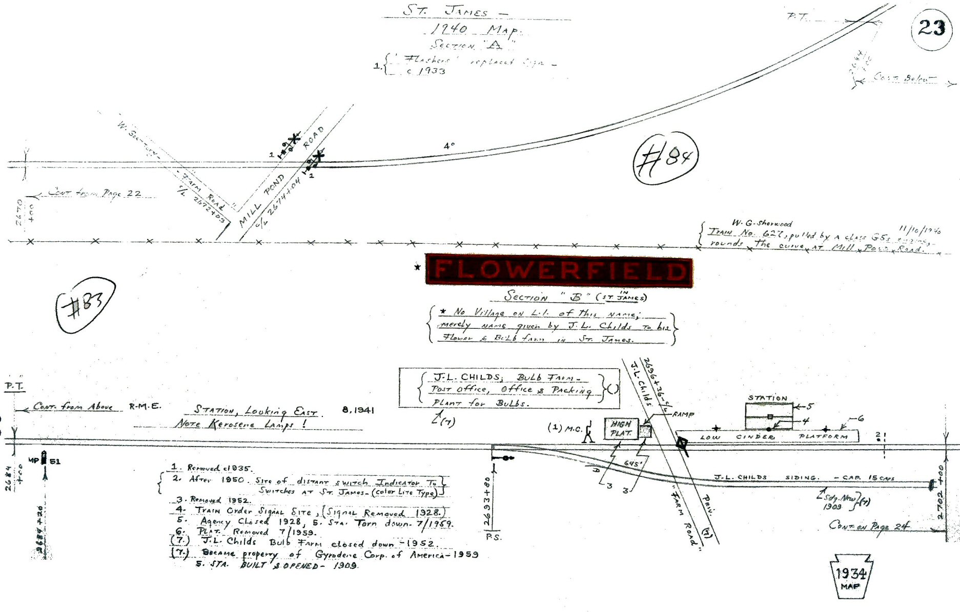
| FLOWERFIELD STATION | |||||||||||||
|
|
OPENED: 1909-10. LISTED IN ETT #108 EFF: 05/23/28 AS OPEN 7 DAYS A WEEK. TICKET OFFICES NOT LISTED IN SUBSEQUENT ETTs. SO UNABLE TO VERIFY WHEN AGENCY CLOSED. A cute and odd little depot, what with the 2nd floor
solarium, |
|
|||||||||||
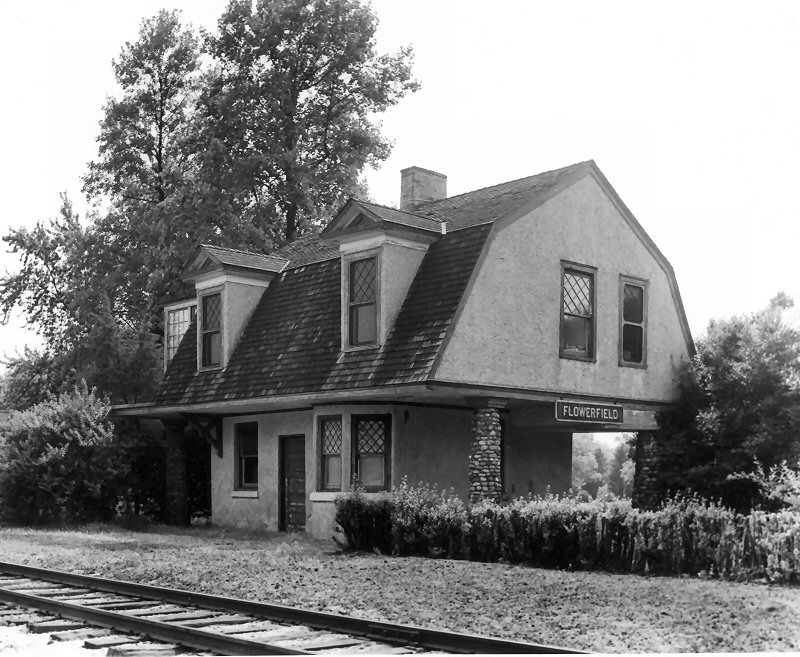 Flowerfield Station View NW c.1953 Archive: Dave Morrison |

Flowerfield Station - LIRR #38 westbound at J. R. Child's private "Farm Rd." View E c.1953 Photo: John Krause Archive: Dave Morrison |
 Flowerfield Station View NE c.1956 Archive: Dave Morrison |
|||||||||||
|
Emery stated in his SUNY map of Flowerfield
(above right) that the train order signal was removed in 1928 and the agency closed that same year.
First, there never was a train order signal at Flowerfield. What was there, and in the position indicated on Emery's map, was a
Flagstop Signal. The c.1927 image shot by James V. Osborne (above left) shows two Dietz kerosene platform lamps with a wooden post between them, located directly in front of the depot. This was the
Flagstop signal post. Later images of this depot show signal post having
been removed. Art Huneke says that his ETT #108 eff. 5/23/1928 indicates ticket office hours and Flowerfield was listed as being open 7 days a week. Subsequent ETTs no longer listed ticket office hours so we couldn't factually say the agency closed in 1928, but it would make sense that WHEN the agency closed, there was no representative of the railroad present and no one to hang the flagstop signal, so it would explain why both the agency closed and the signal and post were removed the same year (probably at the same time), 1928 is as likely a date for this to have occurred. Then again, Emery may have spoken with Osborne when he was drawing these maps and he may have remembered when the agency closed. (Osborne retired from the LIRR in 1971 after 50 years of service! Osborne and Emery's dad both were block operators.) Research: Dave Keller |
|||||||||||||
|
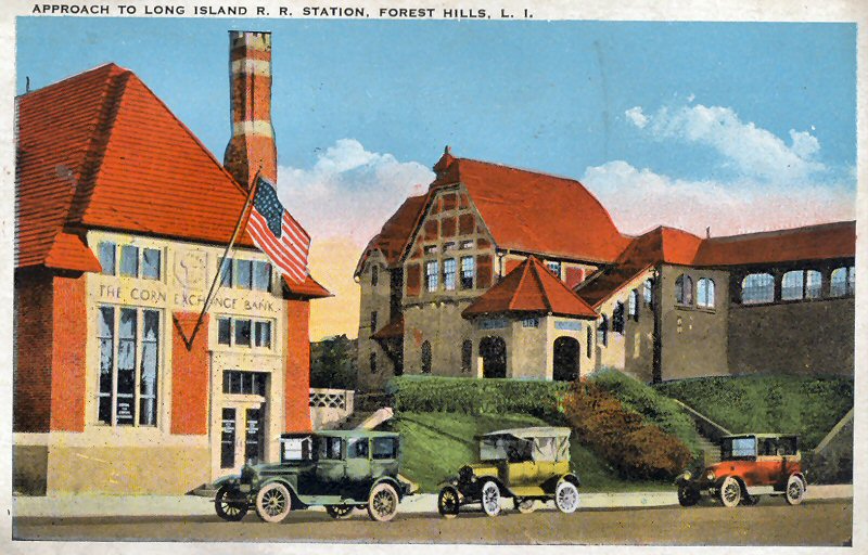
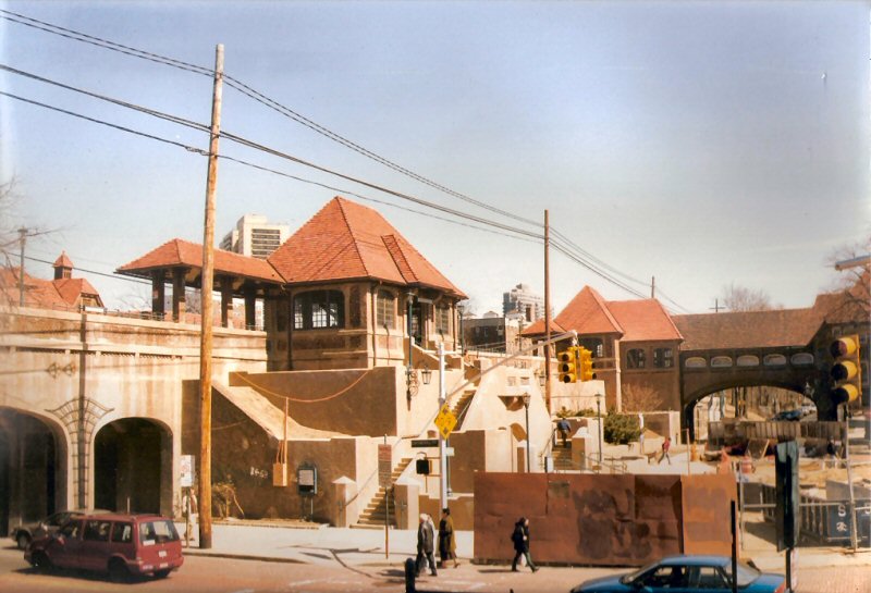
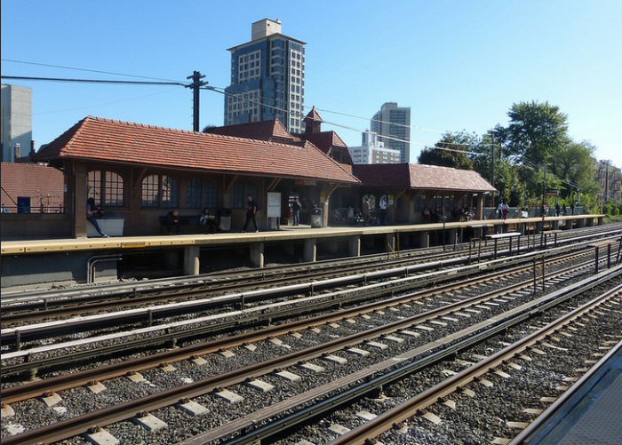
FOREST HILLS STATION
FOREST HILLS MAIN LINE BUILT: 1906, CLOSED: 1911 2ND DEPOT OPENED: 8/5/1911. AGENCY CLOSED: 8/19/2009. |
|||||||||||||
 Opening Day Ticket September 8, 1910 Forest Hill to NY Penn Archive: Jerome Landsman  |
PART 5: PENN STATION OPENS AND A
SUBURBAN COLOSSUS EMERGES by George Chiasson, Jr. On September 8, 1910, electrified
service was operated on the following complete routes, in general using
MP-54 type steel Multiple-Unit equipment, Hempstead Branch: Penn Station to
Hempstead via Jamaica and Floral Park. Stops at Woodside, Winfield,
|
||||||||||||
 Forest Hills Station view NE c.1925 Photo: James Osborne
|
|
|
|||||||||||
| GARDEN CITY STATION - NASSAU BLVD | |||||||||||||
 Garden City - Nassau Blvd. View W 1960 Photo: LIRR Archive: Jim Gillin |
BUILT: 1907. AGENCY CLOSED: ? (GARDEN
CITY)
|
||||||||||||
| GLEN COVE - NASSAU STATION | |||||||||||||
 Glen Cove view NE 1903
|
BUILT: JULY-AUG/1895. AGENCY (NASSAU) CLOSED: ? Glen Cove,
Nassau station, looking northeast 1903. Check
out the bicycle propped against the ticket office rounded bay window, the
hand truck near the bike and the old express wagon under the covered
platform, center, and there are ELECTRIC platform lamps with wiring coming
off the depot’s eaves! Info/Archive: Dave Keller |
||||||||||||
| GLEN HEAD STATION | |||||||||||||
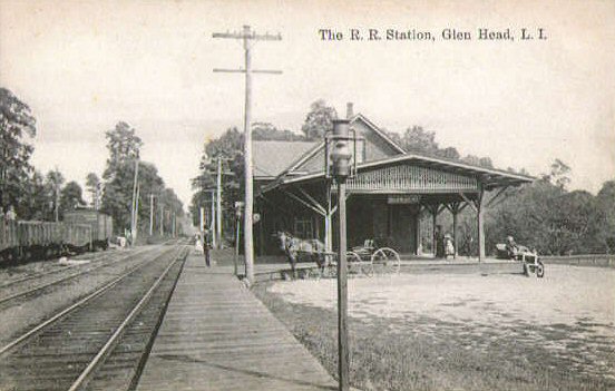 Glen Head c.1910  Glen Head 1960 Photo: LIRR Archive: Jim Gillin |
ORIGINAL DEPOT OPENED: 1/23/1865 |
||||||||||||
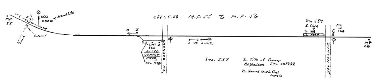
| HAGERMAN STATION | |||||||||||||
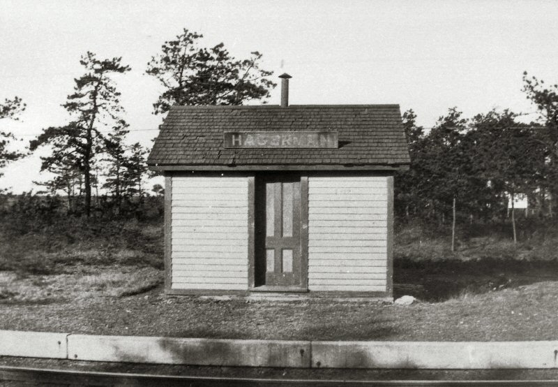
Hagerman Station c.1925 Photo: James V. Osborne Archive: Dave Keller |
BUILT: 10/1890, BY LAND DEVELOPER
(EAST PATCHOGUE) FREDERICK W. DUNTON, NEPHEW OF |
|
|||||||||||
| HEMPSTEAD STATION | |||||||||||||
|
HEMPSTEAD C.R.R. depot built:
Oct-Dec/1872 at Fulton Avenue and became LIRR’s Hempstead Station and
terminus in 1878. Remodeled: 7/1881. Razed: 1913. |
|||||||||||||
|
|
 Hempstead Station valuation photo view NW 6/17/1943 The image, above, shows the Hempstead station building after it was moved back to Columbia Street, from Fulton Ave. The notation on the back of the image states that it's a "completion shot" but although it was photographed in June, 1943, it does not mean that the relocated depot was opened then. It could have been opened a month earlier and the photographer only told to photograph it in June. Research: Dave Keller Hard to imagine that the image from 1960
(below) shows the SAME depot with the same Spanish tiles (47 years in
place!) yet after the major fire of 1962 the roof style was changed by
eliminating the stylish upward curve of the eaves at the ends, ugly rooftop
dormers were added which were NOT in keeping with the architectural style
AND the Spanish tiles were replaced by hum-drum, 3-tab, asphalt roof
shingles. |
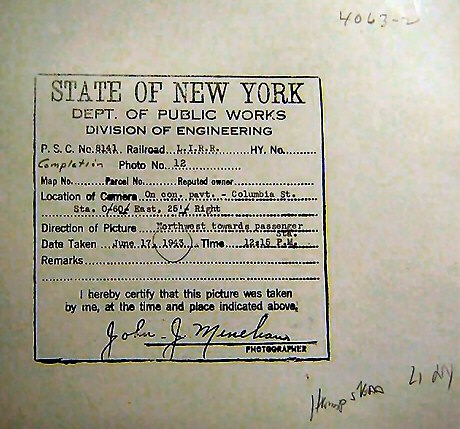 Hempstead Station valuation photo view NW 6/17/1943 reverse
|
|||||||||||
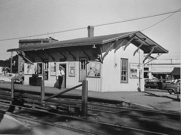
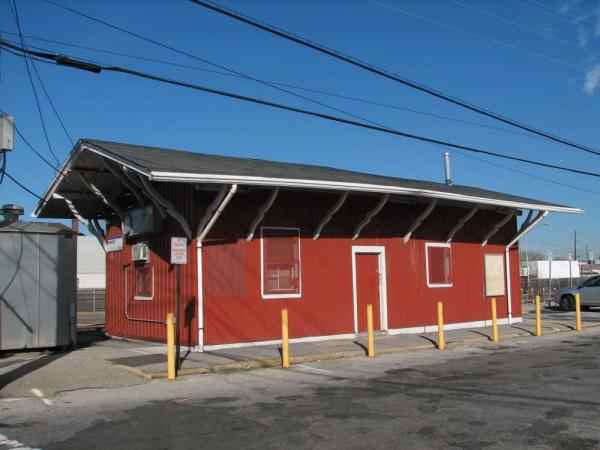
| HEWLETT STATION | |||||||||||||
|
SOUTH SIDE R.R. BEGAN SVC: 7/1869 AS “HEWLETTS.” DEPOT BUILT: 1870 (Per Vincent Seyfried’s LIRR history) ON SOUTH SIDE OF TRACKS EAST OF FRANKLIN AVE. TRADITION SAYS CONSTRUCTION WAS PAID FOR BY THE HEWLETT FAMILY. REPLACED BY NEW DEPOT: 7/28/2003. 2ND DEPOT OPENED: 7/28/2003, ON N. SIDE OF, AND PERPENDICULAR TO, THE TRACKS AND W. OF FRANKLIN AVE. AGENCY CLOSED: 8/19/2009. ORIGINAL DEPOT USED BY LIRR PERSONNEL. STILL STANDING: 2014. |
|||||||||||||
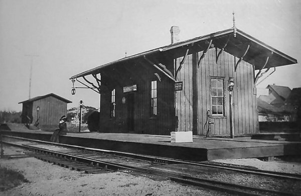 Station Hewlett c.1890 |
.jpg) Hewlett MU Train 1959 (Edwards-Keller) |
 Hewlett view SE 1960 Archive: Ron Ziel |
|||||||||||
.jpg) Hewlett Station view NW 1967 Photo/Archive: Dave Keller |
.jpg) Hewlett Station view NE 1968 Photo/Archive: Dave Keller |
.jpg) Hewlett Station view SE 1968 Photo/Archive: Dave Keller |
|||||||||||
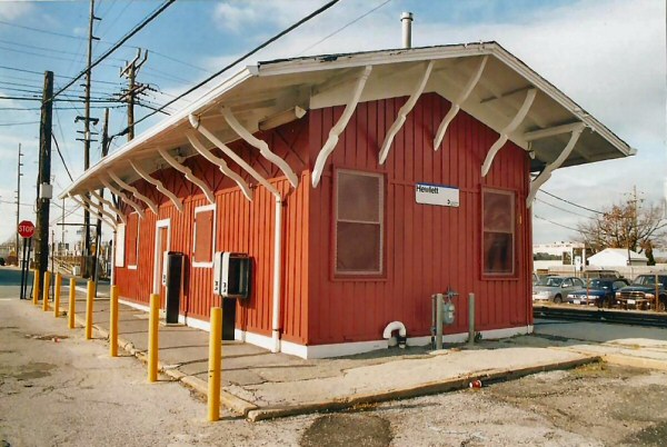 Hewlett Station 03/2004 view NW Photo: William Gilligan |
 Hewlett Station view NE |
 2nd Hewlett Station 03/2004 view NW Photo: William Gilligan |
|||||||||||
|
S.
SIDE R.R. Began service: 7/1869 as “HEWLETTS.” 2nd Depot opened: 7/28/2003, It sets at a 90 degree angle from the old depot, and is located on the north side of the tracks, and on the west side of the road crossing the tracks. Agency closed: 8/19/2009. |
|||||||||||||
| HOLTSVILLE STATION | |||||||||||||
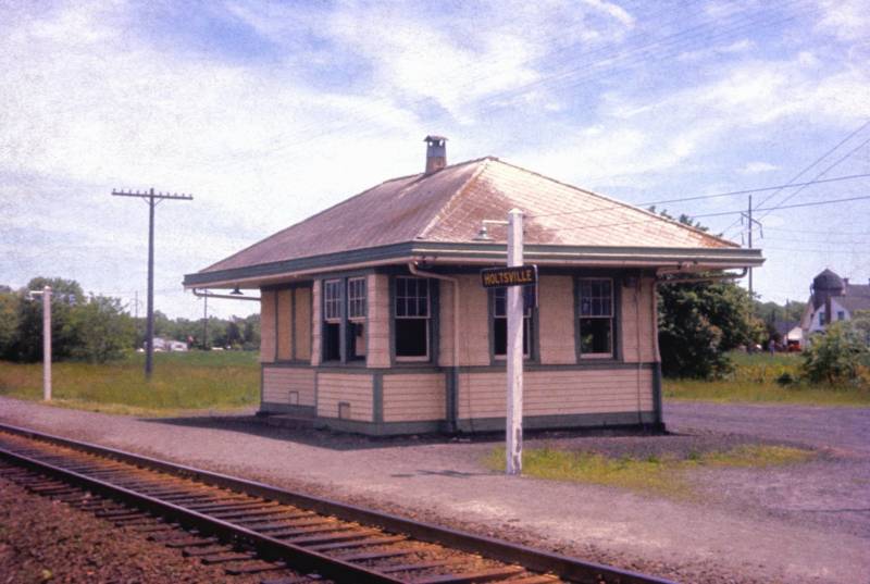 Holtsville Station 06/1960 Photo/Archive: Art Huneke |
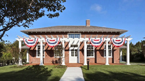
OLD STORE SERVED AS
ORIGINAL “WAVERLY” DEPOT UPON OPENING OF LINE IN 1843, RENAMED HOLTSVILLE: 1860, ORIGINAL PRE-1843 STRUCTURE RAZED: 1912 |
||||||||||||
| HUNTINGTON STATION | |||||||||||||
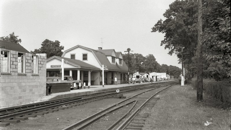 Huntington Station UN Block Crossover 08/28/1951 Archive/Info: Dave Keller |
HUNTINGTON STA. BUILT: 1868 (?),
CLOSED: 1909
|
||||||||||||
| KEW GARDENS STATION | |||||||||||||
|
KEW OPENED: 9/8/1910 ON RE-ALIGNED
MAIN LINE TRACKS SOUTH OF EX-MAPLE GROVE STATION SITE.
RENAMED “KEW GARDENS”: 1912.
AGENCY CLOSED: 8/19/2009. |
|||||||||||||
Kew Gardens c.1912+ Archive: Jim Gillin  Kew Gardens - 1912 Archive: Kim Granzow |
|
 Kew Gardens Station - c.1955 Photo: Frank Ingalis Archive: NY Historical Society
|
 Kew Gardens Station - 1965
|
||||||||||
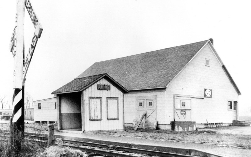
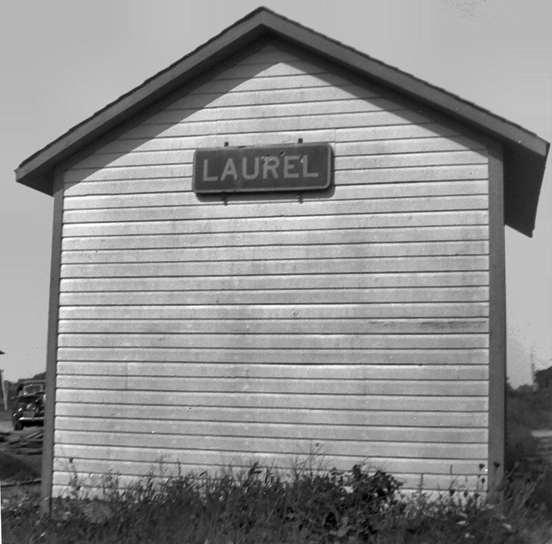
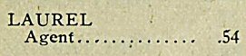
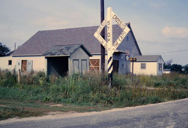
| LAUREL STATION | |||||||||||||
|
LAUREL: STATION STOP ORIGINALLY APPEARS AS “FRANKLINVILLE.” NOT LISTED ON TT OF 10/1880 or 1881. DEPOT BUILT: 1901, REMODELED INTO SHELTER SHED: 1939, RAZED: 1967. LAST LISTED IN ETT #1, EFF: 5/22/66 |
 Emery map Laurel MP79-81 Archive: Dave Keller |
||||||||||||
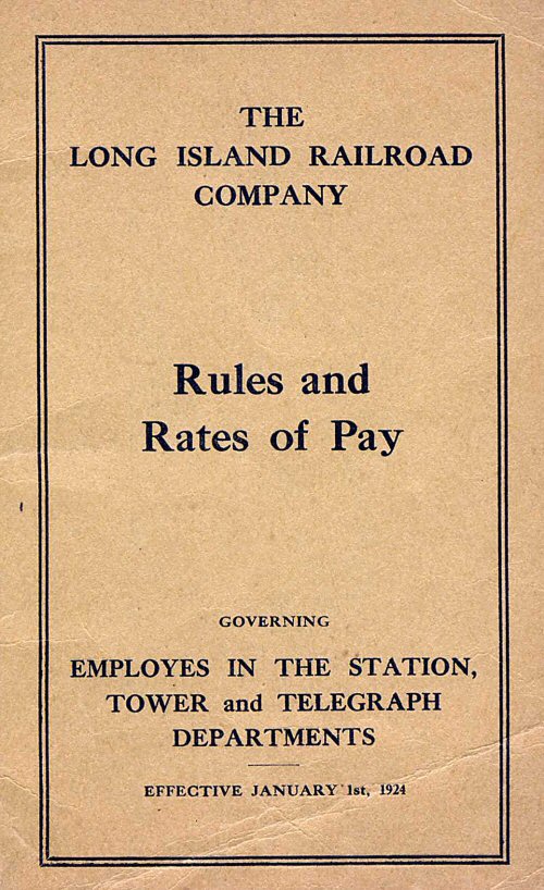 LIRR Rules and Rates of Pay 1/01/1924 Archive: Dave Keller |
|
 Laurel Station - View NW 4/19/1953 (Wetterau-Viken - Morrison) Note: Papish Produce Potato House in rear
|
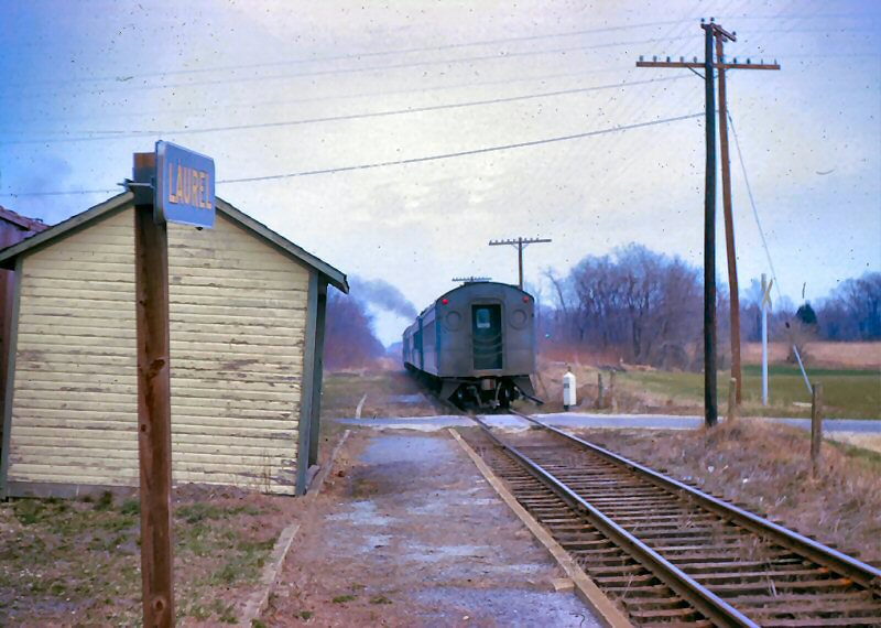 Laurel Station -Train #204 eastbound MP80 3/1966 Archive: Brad Phillips
|
||||||||||
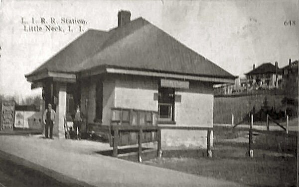
| LITTLE NECK STATION | |||||||||||||
 Little Neck Station view SE c.1910 |
FLUSHING R.R. Appears
on timetable of 1866 |
 Little Neck view NE 11/05/2008 Photo: Robert Anderson |
|||||||||||
| MANORVILLE (MANOR) STATION | |||||||||||||
|
APPEARS ON TIMETABLE OF 6/14/1845 AS
“ST. GEORGE’S MANOR” AND IN 1852, SHORTENED TO “MANOR.” RAZED: 9/1869 - (Per
local history, the first station agent, Seth Raynor, a patriot of the
American Revolution, painted out the “St. George’s,” leaving “Manor.”) |
|||||||||||||
 Manorville Junction Station 1906 Archive: Dave Keller |
|
 Manorville Station - Summer of 1968, shortly prior to its being razed. All structures in this image, including the station platform, are all gone. Photo/Archive: Dave Keller |
|||||||||||
| MASTIC STATION | |||||||||||||
%20-%20c.%201900%20(Keller).jpg) Mastic Station with Agent - View NE c.1900 Archive: Dave Keller
|
BUILT: 1882 AS “FORGE”, RENAMED:
1893.
|
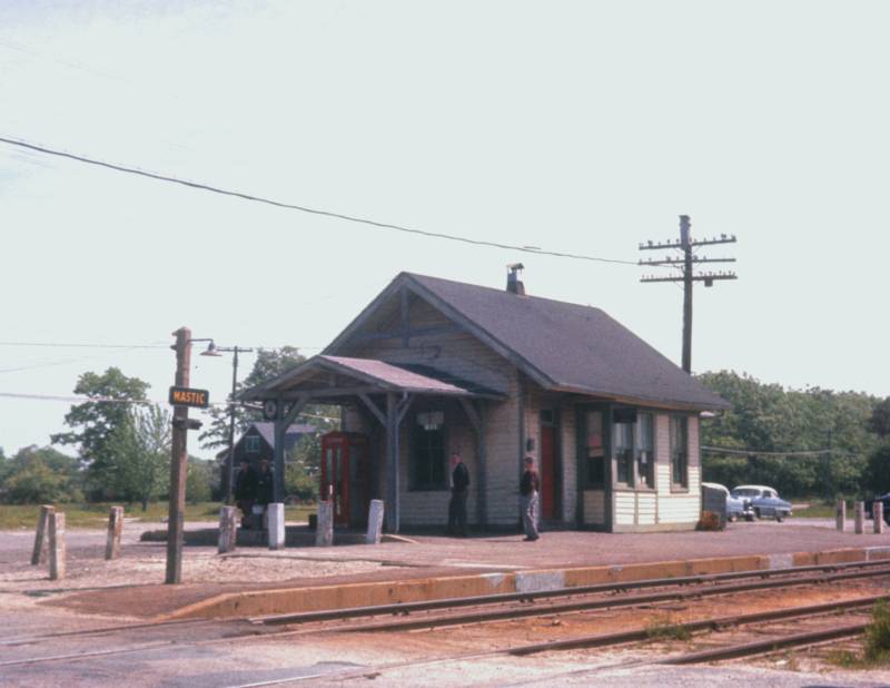 Mastic Station 1960 Photo/Archive: Art Huneke |
|||||||||||
| MASTIC-SHIRLEY STATION | |||||||||||||
|
MASTIC-SHIRLEY:
IN SERVICE: 7/15/60. AGENCY AND BLOCK STATION CLOSED: 19_?_. |
|||||||||||||
 Mastic-Shirley Station 6/15/1978 View SW - Archive: Dave Morrison |
|
 Mastic-Shirley Station 1966 View SE - Photo/Archive: Dave Keller |
|||||||||||
| MEDFORD STATION | |||||||||||||
|
|
1ST DEPOT
OPENED: 6/26/1844 WITH OPENING OF LIRR OUT TO TEMPORARY END-OF-TRACK AT
CARMAN’S RIVER. BURNED: 8/20/1863 2ND (?)
DEPOT BUILT: 1889 WITH ATTACHED AGENT’S QUARTERS. LOCATED ALONGSIDE 3RD
ELEVATED DEPOT, MAIN TRACK, AND TEAM TRACK IN SVC: 9/9/40. TICKET OFFICE /
WAITING ROOM AT TRACK LEVEL. EXPRESS / BAGGAGE OFFICE AT GRADE WITH LONG,
CONCRETE RAMP EXTENDING TO PLATFORM LEVEL. PASSING SIDING IN SVC: 11/2/40.
PART TIME AGENCY CLOSED: 1958. UPPER LEVEL OF STRUCTURE HEAVILY VANDALIZED
AND RAZED: 1964. LOWER LEVEL WINDOWS AND DOOR BLOCKED UP AND STRUCTURE
FILLED WITH DIRT. METAL SHELTER SHED ERECTED ATOP LOWER STRUCTURE. 4TH
ELEVATED DEPOT WITH HI-LEVEL PLATFORMS BUILT: 2000-2001 |
||||||||||||
| MILL NECK STATION | |||||||||||||
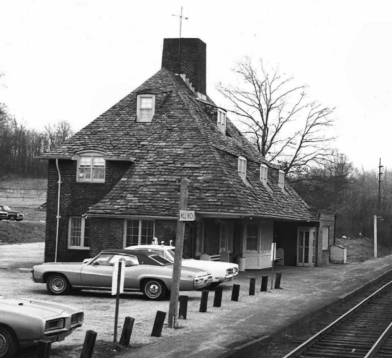 Mill Neck station view E 3/21/1971 Photo: Jeff Kuhn
|
Original
depot opened: 11/1892 on east side of Shu Swamp to replace discontinued Bayville Station ˝ mile further west. (per 11/3/1892
edition |
||||||||||||
| NAPEAGUE BEACH STATION | |||||||||||||
 Napeague Beach view E c.1924 (Osborne-Keller) |
|
||||||||||||
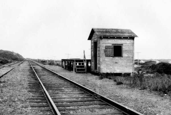
| NEW HYDE PARK STATION | |||||||||||||
|
1ST DEPOT BUILT: c. 1837 AS “HYDE PARK” WITH OPENING OF LIRR TO HICKSVILLE. RENAMED “NEW HYDE PARK. |
|||||||||||||
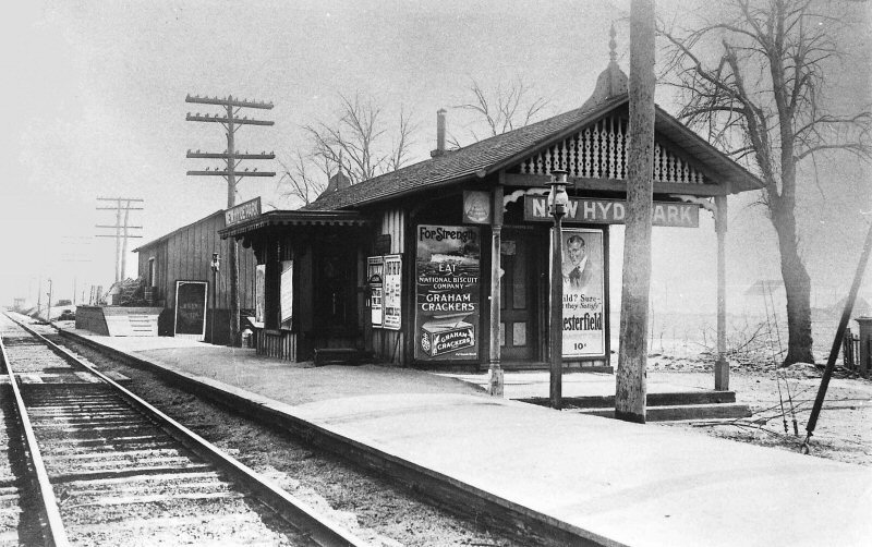 New Hyde Park Station 1918 View SE (Dave Keller archive) |
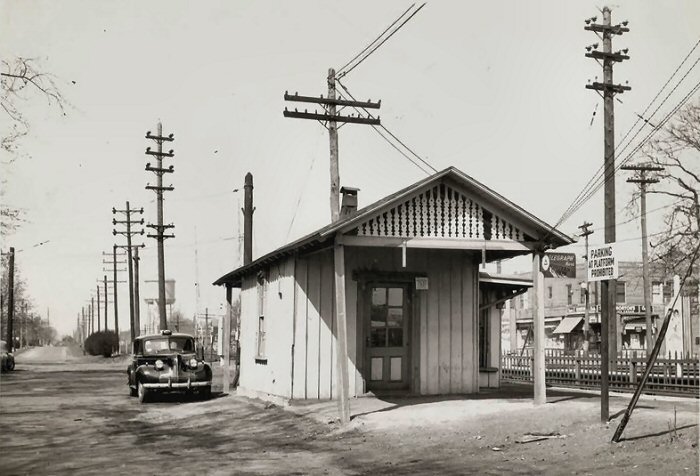 New Hyde Park Station c.1948 |
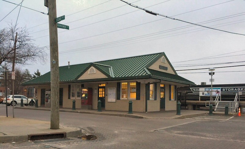 New Hyde Park Station c.2005 |
|||||||||||
| NORTHPORT STATION | |||||||||||||
| BUILT: MAY-JULY/1873, MOVED TO PRIVATE LOCATION 1927. RAZED: 1959, 2ND DEPOT BUILT: 1927 AGENCY CLOSED: 8/19/2009. Research: Dave Keller | |||||||||||||
 Northport c.1910 Northport station as it
looked c. 1910 with a Northport Trolley behind the depot. Archive: Dave
Keller |
When I was an Extra Agent in the mid 1970's I covered a job that assisted in Northport on Monday mornings. The regular Agent whose last name was Pederson gave me this. It is printed as a postcard. Info: Jim Gillin |
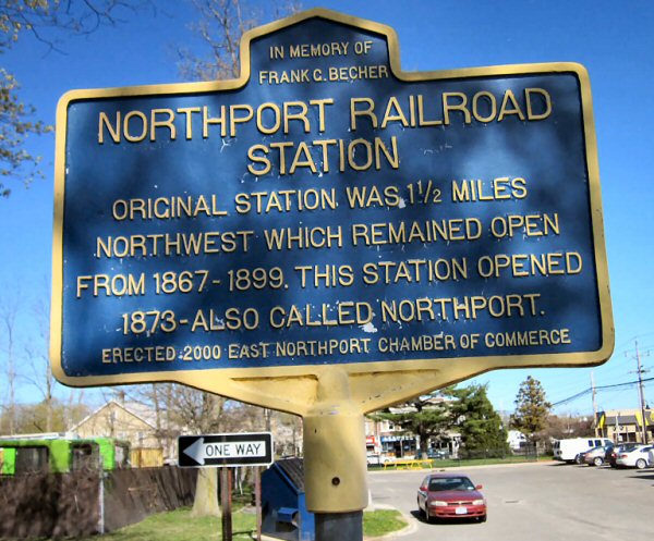 Northport Station historic marker Photo: Dave Morrison |
|||||||||||
|
|
|||||||||||||
| OCEANSIDE STATION | |||||||||||||
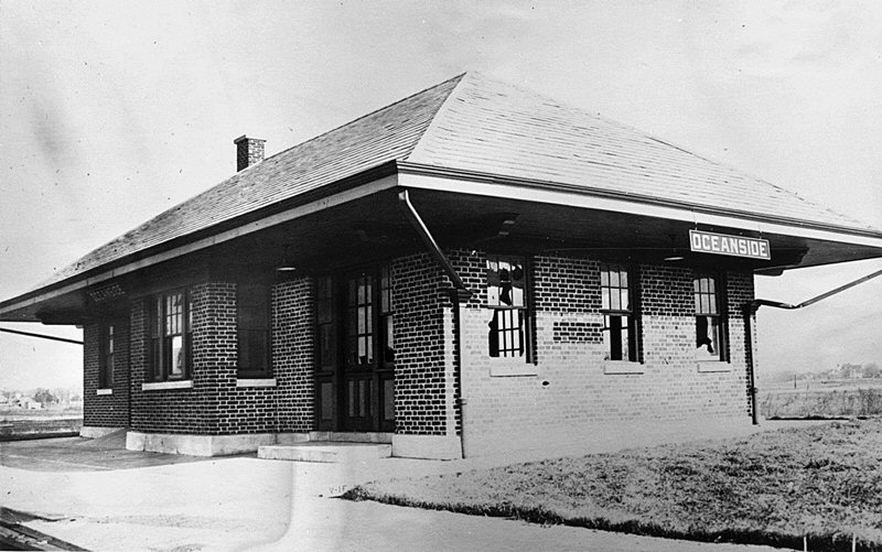
Oceanside LIRR valuation photo c.1920 Archive: Art Huneke |
OPENED: 5/1/15, BURNED: c. 1958-59 |
||||||||||||
| ORIENTAL HOTEL STATION | |||||||||||||
 Oriental Hotel Coney Island Manhattan Beach view E 1903 Photo: Shorpy Archive: Dave Keller Behind the hotel on the bay side the LIRR had a right-of-way and train service. The hotel had its own station called Oriental Hotel. |
Ornate depot in oriental
style to service patrons of the beach front First appears on timetables of 1883. Discontinued ? |
The Forney
#211 was originally #154 built in 1892 and renumbered 1n 1898. The rapid
transit cars were built in 1898 -99 for Brooklyn Bridge service as the
center doors were only used at Brooklyn Bridge where they were opened by men
on the station platform. The cars were wired for use with MP41's in 1905. Info: Art Huneke |
|||||||||||
| PINE AIRE STATION | |||||||||||||
|
BUILT:
1915, RAZED: 6/62 |
|||||||||||||
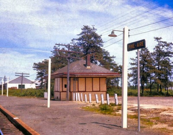 Pine Aire Station view SE 1960 Photo: Art Huneke |
 LIRR #152 and hack C57 are ready to go west, once their crew comes on duty later that evening. Pinelawn. Winter of 1985. Photo/Archive: Jay Bendersky |
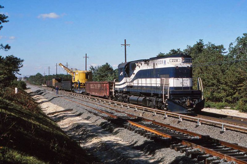 An L-2, a Work Crane, and a Hack - what more could you want on this work extra? No. 2 Track is taking shape as the Work Extra 228 East holds the Main at MP39, just west of Pine Aire Station. One year to go before the DC goes live! October 1986. Photo/Archive: Jay Bendersky |
|||||||||||
| PINELAWN STATION | |||||||||||||
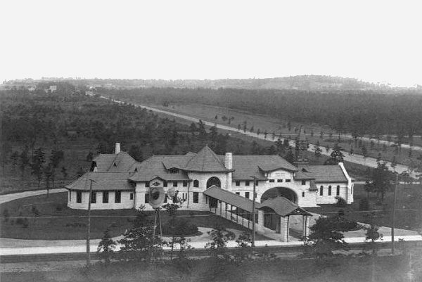 Pinelawn Cemetery 1910 Archive: Dave Keller 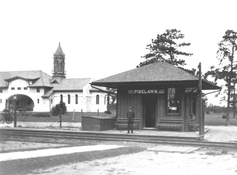 Pinelawn 1908 (Art Huneke archive) |
OPENED: 8/30/1904 WITH FANCY
TICKET OFFICE LOCATED IN THE
|
||||||||||||
| PORT JEFFERSON | |||||||||||||
|
|
OPENED: 1/1873, BURNED: 2/1/1874 |
||||||||||||
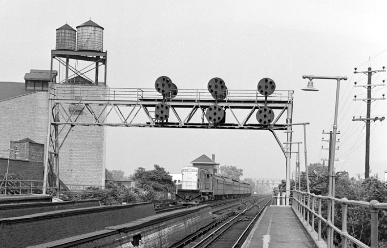
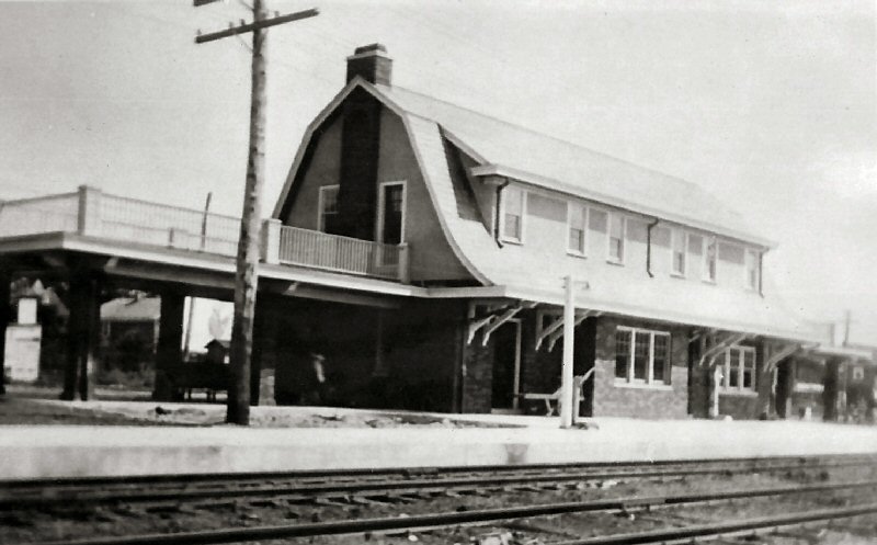
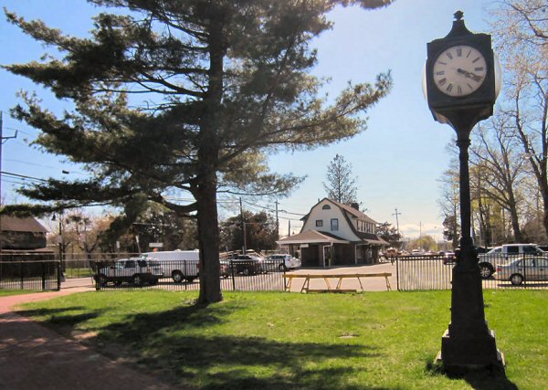
QUEENS (VILLAGE) STATION
=
 |
|||||||||||||
|
|
QUEENS: FORMERLY "INGLEWOOD" STATION. RENAMED: 10/1881 AS “QUEENS”, MOVED TO PRIVATE LOCATION: 1924 WITH GRADE ELIMINATION. (SEE: “QUEENS VILLAGE”)
QUEENS VILLAGE:
OPENED: 10/1881 AS “QUEENS”,
MOVED TO PRIVATE LOCATION:
1924 WITH GRADE ELIMINATION.
|
||||||||||||
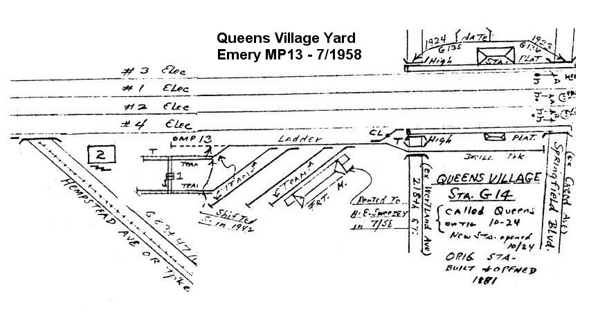
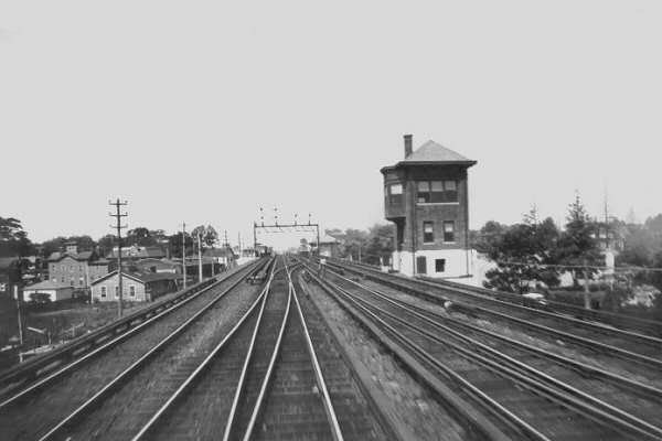
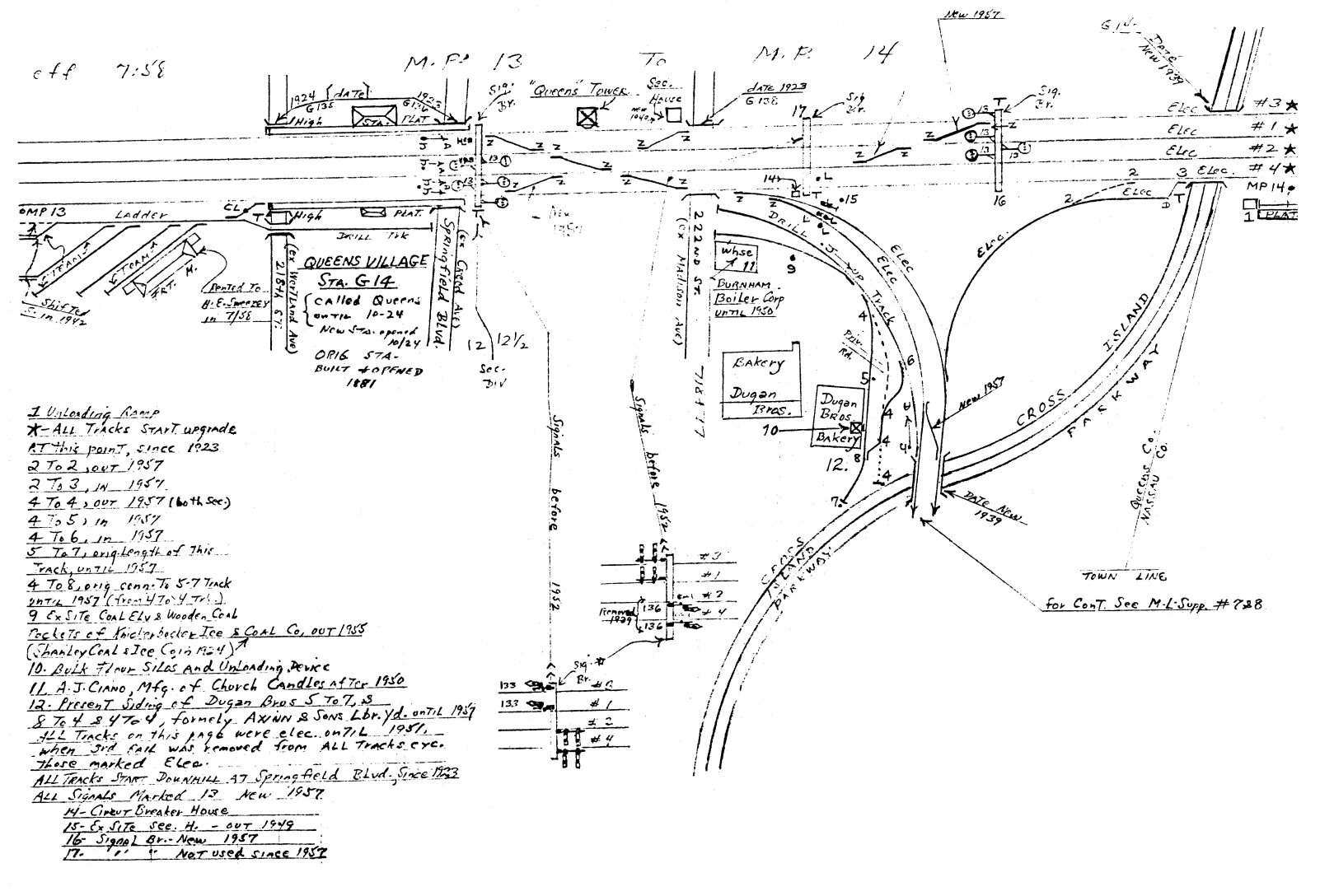 Emery map - Queens Village MP13-14 7/1958 Archive: Dave Keller
|
Queens Village, Springfield Blvd. View E |
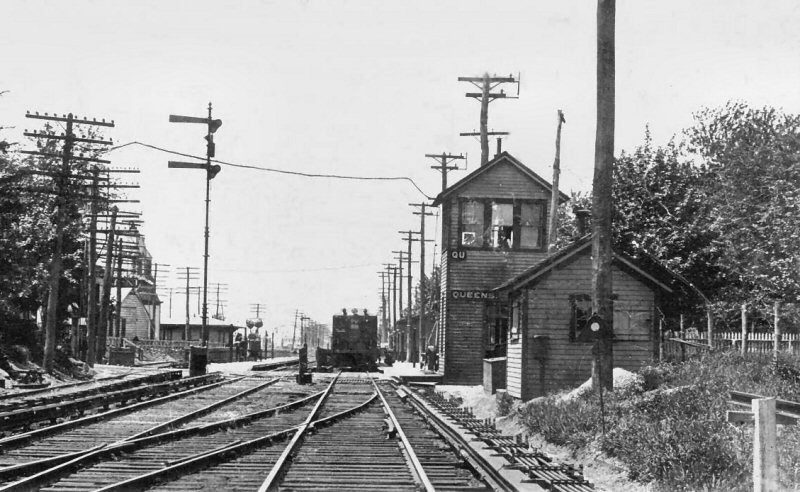 QU Tower: 1 (Tower 45) Queens Village View W c.1912 Archive: Art Huneke
|
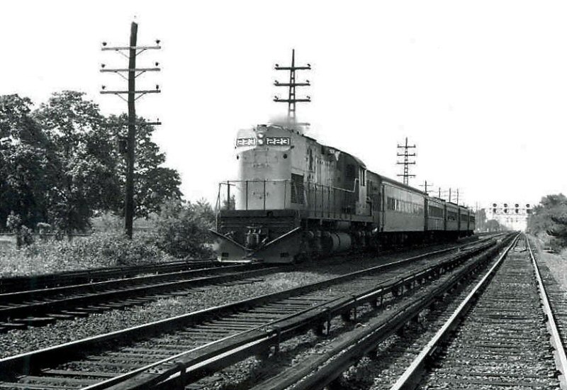 C420 #223 & train eastbound between Signal Bridges #2-3 in 1971 Photo/Archive: Edward Wheeler |
||||||||||
| Note: Freight house and team yard gantry crane are gone. The yard is used to house the LORAM rail grinder equipment and other engineering/MOW equipment. Caboose C-69 has been a frequent resident. 3/2023 | |||||||||||||
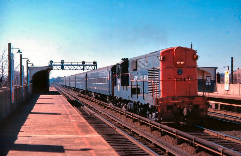 H16-44 #1504 Queens Village - View W 3/18/1962 Photo: Richard Adams Archive: Tim Darnell |
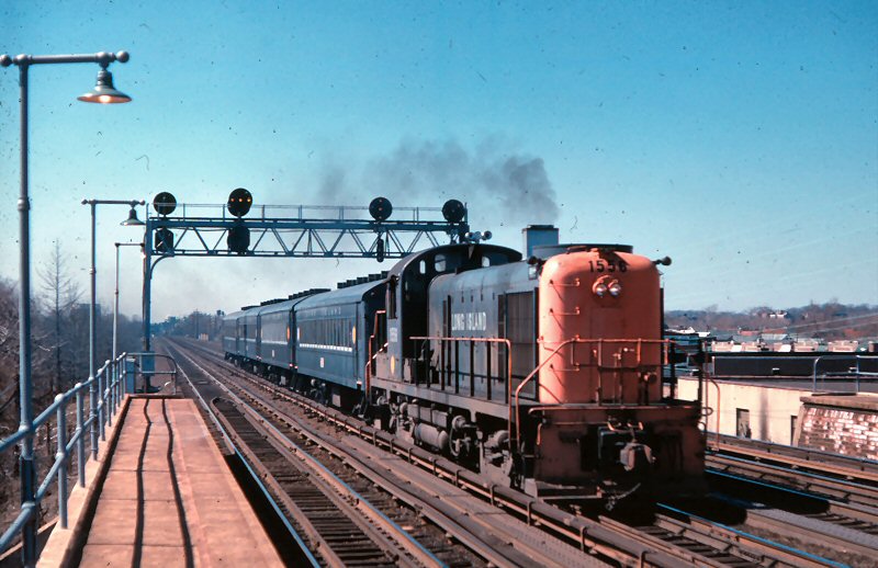 RS3 #1556 Queens Village - View W 3/18/1962 Photo: Richard Adams Archive: Tim Darnell |
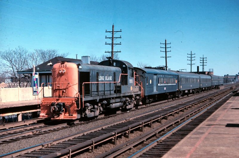 RS3 #1555 Queens Village - View E 3/18/1962 Photo: Richard Adams Archive: Tim Darnell |
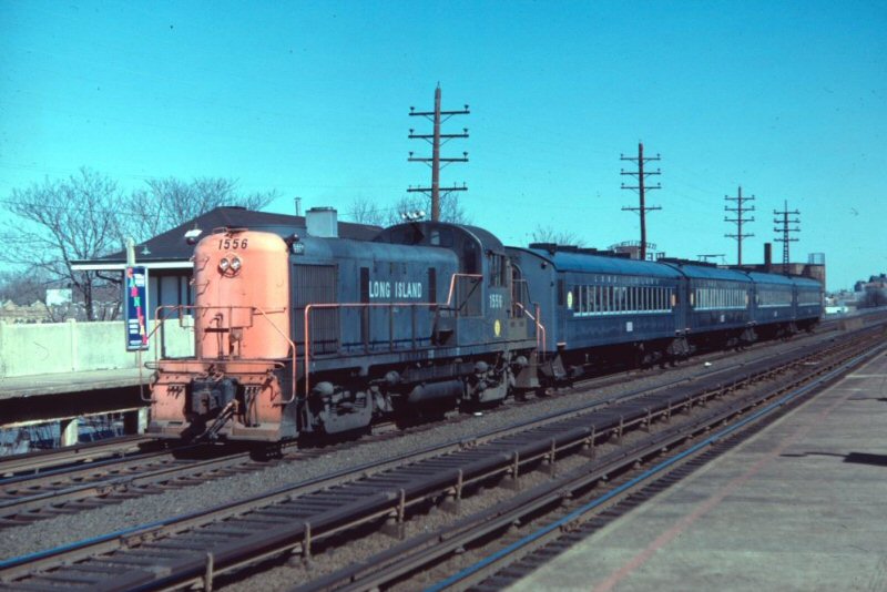 RS3 #1556 Queens Village - View E 3/18/1962 Photo: Richard Adams Archive: Tim Darnell |
||||||||||
| QUOGUE STATION | |||||||||||||
|
|
BUILT: 6/1875 |
||||||||||||
|
ROCKVILLE CENTRE |
|||||||||||||
 Rockville Centre Sstation colorized post card c.1915 |
South
Side 2nd
Depot opened: 10/14/1901, Razed: 3/49 with grade elimination. Elevated
structure in service: 7/17-18/50
|
||||||||||||
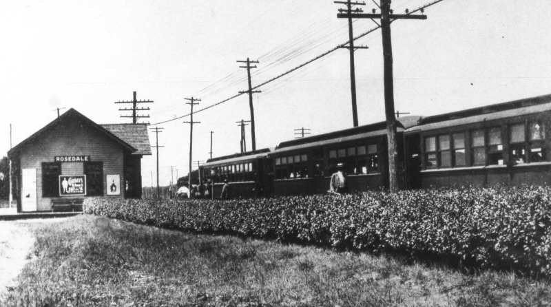
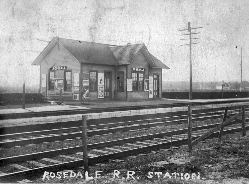
| ROSEDALE | |||||||||||||
|
SOUTH
SIDE R.R. SERVICE BEGAN: (ATLANTIC) 10/28/1867 AS “FOSTER’S MEADOW.”
DEPOT BUILT: 7/1871 (4-yeargap??) OUT OF SVC: 1889.
MAY HAVE BEEN USED AS FREIGHT HOUSE FOR 2ND DEPOT. RAZED: ? |
|||||||||||||
 Rosedale c.1910 MP41 sandwich train: one steel car on either side of a center-door wooden trailer Archive/Info: Dave Keller |
 Rosedale c.1920 Archive: Steve Swirsky |
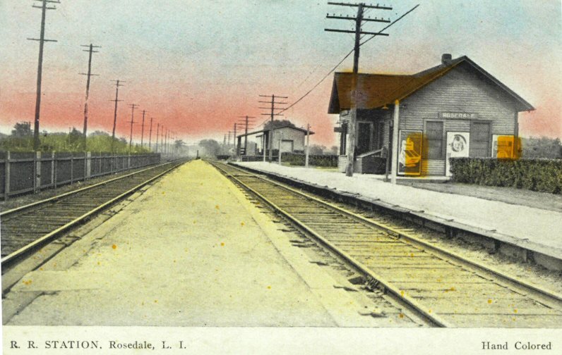 Rosedale colorized post card View E Archive: Steve Swirsky |
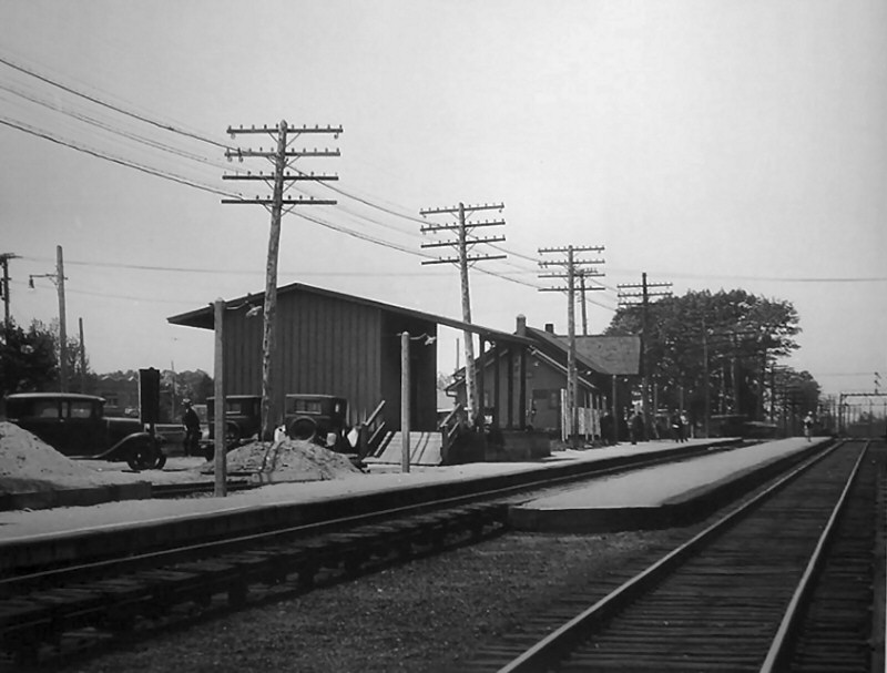 Rosedale view SW 1931 |
||||||||||
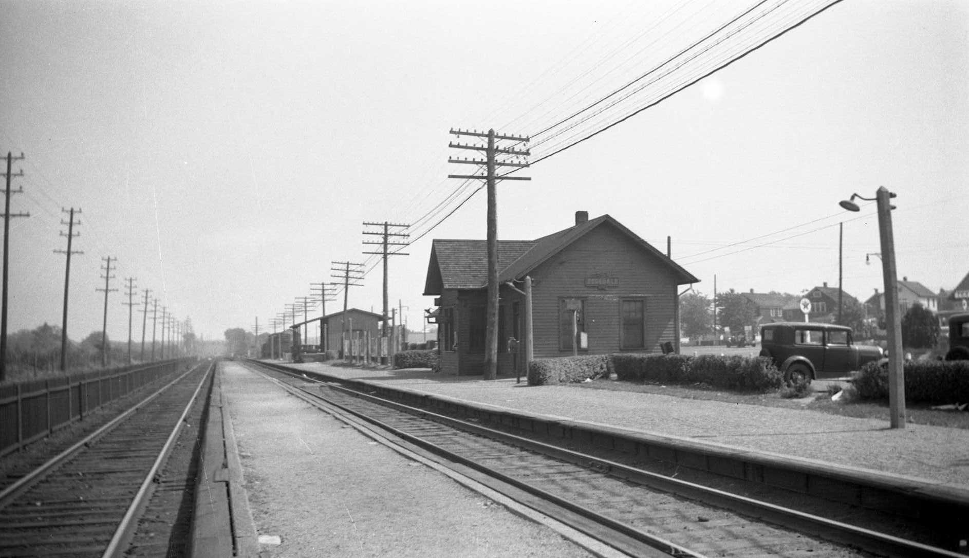 Rosedale view E 4/14/1931 Archive: Dave Keller |
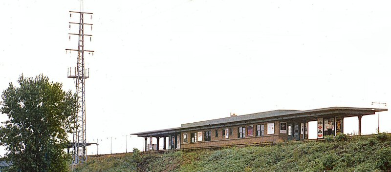 Rosedale View SE 9/1965 Photo/Archive: Brad Phillips |
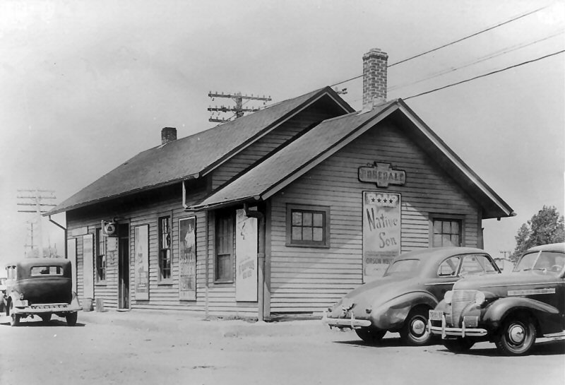 Rosedale Station - View SE Summer 1941 |
|||||||||||
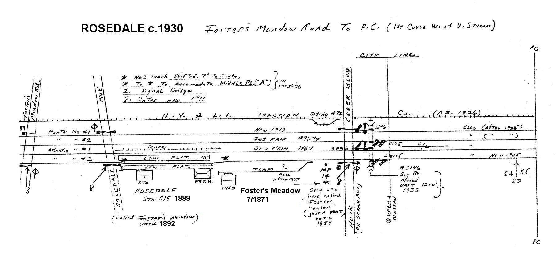 Emery Map - Rosedale 1930 Archive: Dave Keller |
|
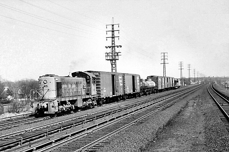 Rosedale Station island platform LIRR S1 #415 freight Photo: c.1960 View E |
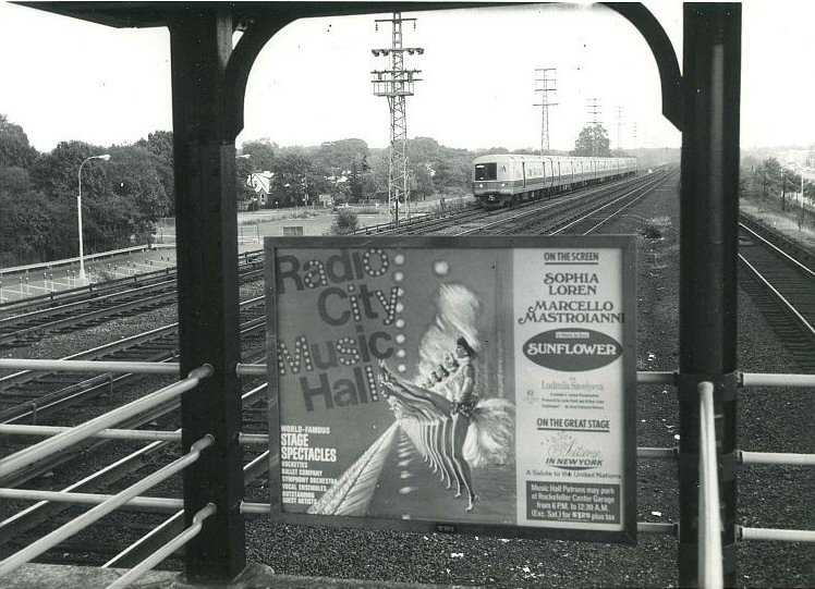 Sunflower movie poster 10/30-11/05/70 LIRR #9155 approaching Rosedale Photo: c. 8/1970 View E |
||||||||||
| SAG HARBOR STATION | |||||||||||||
|
|
OPENED: 1/1871, PERPENDICULAR TO END OF TRACK MOVED: 2/1871, BURNED: 11/1873
|
||||||||||||
| SHINNECOCK HILLS STATION | |||||||||||||
 Shinnecock Hills Station view SE c.1910. The track in the foreground closest to the photographer was the passing siding with a 16-car capacity. A team track led from it on the east end, running north of the siding westward. The team track was removed in 1930 and the passing siding in 1934. (See Robert Emery's map below right) (Dave Keller data) |
BUILT: APR-MAY/1887 WITH OPEN AIR VIEW PORTS IN TURRET TO OVERLOOK GREAT PECONIC BAY. LOW PLATFORM REMOVED: 1931 (Robt. Emery data). AGENCY CLOSED: 9/21/32. STATION STOP DISCONTINUED SHORTLY AFTER TIME- TABLE OF 9/32 WAS ISSUED, WHICH LISTED ONE TRAIN MAKING A FLAG- STOP. STATION CONTINUED TO BE LISTED ON TIMETABLES OF 1934 AND 1935 WITH NO TRAINS SCHEDULED TO STOP. LATER USED AS A U.S. POST OFFICE WITH ACTIVE MAIL CRANE UNTIL LIRR RPO SERVICE ENDED IN 1965. POSTAL FACILITY CLOSED: 1966. BUILDING ABANDONED AND PURCHASED IN 1974 FOR USE AS A PRIVATE RESIDENCE IN SITU. DESIGNATED A LOCAL SOUTHAMPTON LANDMARK: 10/22/2013. The LIRR built its branch from Manorville SE to Moriches and then E along the south shore to Bridgehampton and NE up to Sag Harbor in 1870. In 1881, the LIRR extended the former SSRR from Patchogue to connect with this branch at the new junction at Eastport, and the Moriches station on the old Sag Harbor branch a short distance west of this junction was lifted off its foundation and moved east and renamed Eastport. The line was extended from Bridgehampton further east to Montauk in 1895. Research: Dave Keller
|
||||||||||||
.jpg) LIRR Rules and Rates of Pay -Station, Tower, and Telegraph 1/01/1924 Archive: Dave Keller |
%20-%20c.%201920%20(Ziel).jpg) Shinnecock Hills Station - KH Block Signal - View SE c.1920 Archive: Ron Ziel Note the eastbound and westbound high level express platforms with a scale on the westbound one. also, the passing siding and the Spanish pan tiles on the roof of the turret. Info: Dave Keller .jpg) LIRR Rules and Rates of Pay -Shinnecock Hills 1/01/1924 There was a full-time agent assigned to the station as of Jan. 1, 1924. Had he been seasonal, the letter "S" would appear next to his position, as is indicated in this Rates of Pay book for "Agent no. 2" at Seaside station. The agent at Shinnecock Hills was paid $ .52 per hour. There was no ticket clerk helper, as business most probably didn't warrant it. In addition, the agent was paid an extra 8-1/4 cents per hour to handle the block. Also note that RENT was included as part of the "perks." Therefore, that portion of the depot on the east side of the ticket bay and turret, including the extension at the rear (see view at right) would have been the agent's living quarters. (Dave Keller data) |
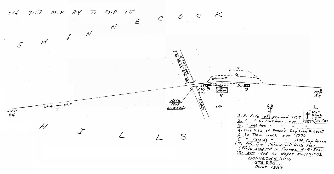 Emery map - Shinnecock Hills MP84-85 7/1958 Archive: Dave Keller
|
|||||||||||
%20-%2010-60%20(Keller).jpg) Shinnecock Hills Station - View E 10/1960 Archive: Dave Keller |
 Shinnecock Hills (KH) MP85 - Prior/Current 2024 Design/Archive: Joe Vila |
 Train westbound at Shinnecock Hills view E 1964 Archive: Brad Phillips |
|||||||||||
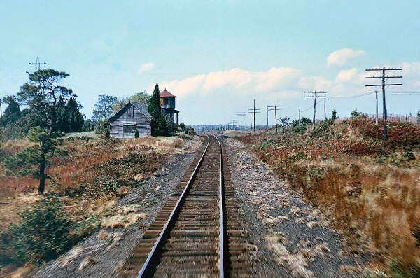 Shinnecock Hills Station view W early 1960's Photo: Steve Hoskins |
 GP-38-2 #274 westbound at Shinnecock Hills 1983 Archive: LIRR/MTA |
||||||||||||
 LIRR #212 C420 eastbound at Shinnecock Hills view W 1966 Photo: Patrick Hamill |
 Shinnecock Hills Station - View SW 1968 Photo/Archive: Dave Keller |
 Shinnecock Hills Station - View SE 1968 Photo/Archive: Dave Keller |
.jpg) Shinnecock Hills view SE 5/07/1978 (Madden-Keller) |
||||||||||
.jpg) Shinnecock Hills view SE from loco cab c.1985 (Collins-Keller) |
 Shinnecock Hills Station - View SW 2/14/2020 |
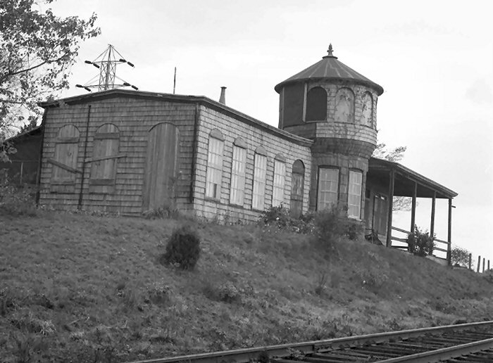
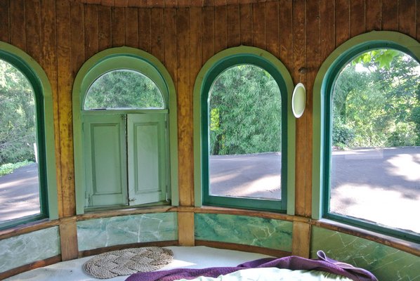 Shinnecock Hills Station restored turret room View S 8/03/2014
|
|||||||||||
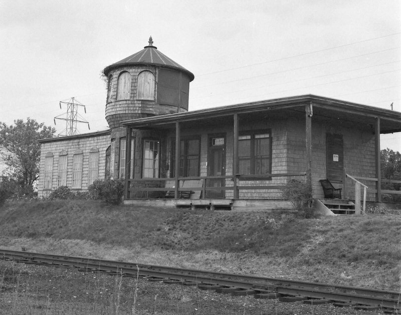
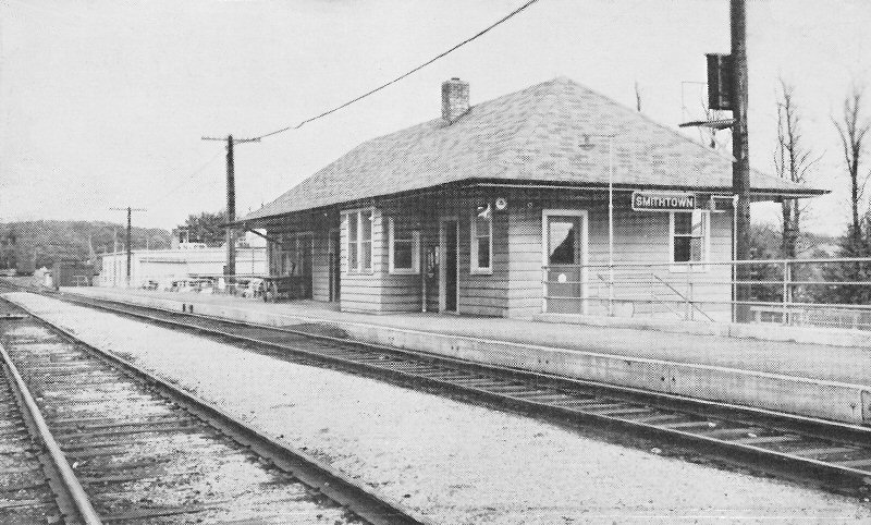
| SMITHTOWN STATION | |||||||||||||
|
BUILT: NOV-DEC/1872, CLOSED: 11/6/36, WITH GRADE CROSSING ELIMINATION OF ROUTES 25 AND 25A. MOVED TO PRIVATE LOCATION: EARLY IN 1937. 2ND, ELEVATED DEPOT IN SVC: 2/18/37. REMODELED: 1987 WITH HI-LEVEL PLATFORM INSTALLATION. Research: Dave Keller |
|||||||||||||
 Smithtown Archive: Jim Gillin |
Once high-level platforms were installed at the station to handle the new push-pull service, the overhanging eaves trackside had to be cut back to allow for passenger clearance overhead, totally ruining the architectural lines of the depot building. When it was
decided to eliminate the grade crossing in
|
||||||||||||
| SOUTHAMPTON STATION | |||||||||||||
|
|
|
OPENED: 2/1871, RAZED: 1902
|
|||||||||||
|
|
Southampton Station Ticket Office |
|||||||||||
 The fireplace and the unique benches on the east wall. The Agent at the time was Charlie Mueller. He supplied the rocking chairs and the artifacts. |
 The ticket counter and windows. |
When I worked there as a Vacation Relief Agent, we only used the window on the right, but Dick Makse says that in the 1960's that the left window was used on Sundays for Parlor car tickets only. Also on Sundays there was a block operator to report trains to the Dispatcher and issue A and K
cards. The operator was there when I worked there. Photos/Archive: Jim Gillin |
|||||||||||
| SOUTHOLD STATION | |||||||||||||
 Southold Station - View SW 4/19/1953 (Richard Wetterau - Dave Morrison) |
SOUTHOLD MAIN LINE 1ST DEPOT APPEARS ON TIMETABLE |
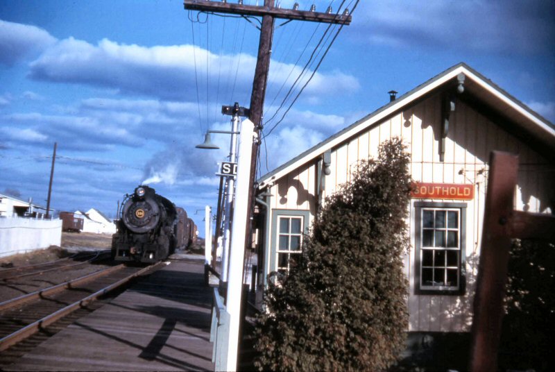 LIRR #108 H10s westbound freight Southold Station 12/1954 (Robert Emery photo, Dave Keller archive) |
|||||||||||
| WAINSCOTT STATION | |||||||||||||
|
Note: Ex-location at the current Wainscott Harbor Rd based on LIRR CR4 3/01/1919 milepost information. Research: Steve Lynch |
|||||||||||||
 Wainscott Station view E c.1925 Photo: James V. Osborne Archive: Dave Keller |
 Wainscott MP 96 - Prior/Current 2024 Design/Archive: Joe Vila |
 Emery map - Wainscott MP96-97 7/1958 - Archive: Dave Keller |
|||||||||||
| WATERMILL STATION | |||||||||||||
|
Built:
Aug-Sept/1875. Listed on timetables of 1883 as "Water Mills" (2
words). Listed on timetables of 1885 as "Watermills" (one word) and
finally listed as "Watermill" |
|||||||||||||
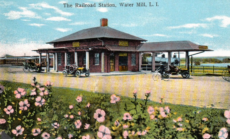 Watermill Station colorized postcard c.1096 Archive: Brad Phillips |
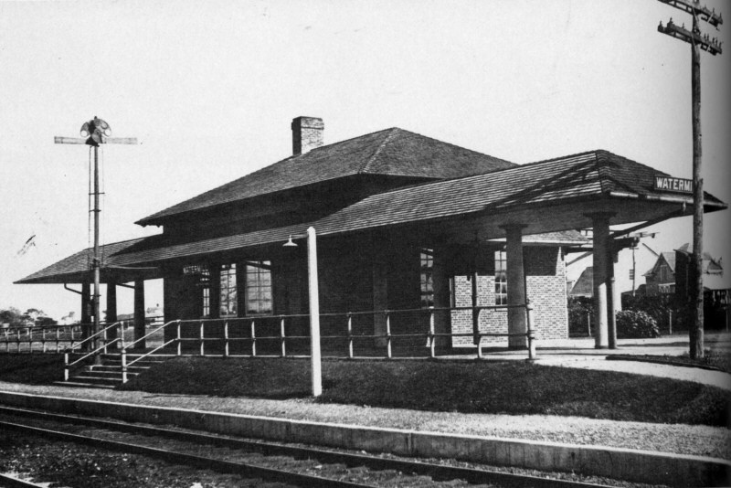 Watermill Station 10/25/1917 Archive: Art Huneke |
 Watermill Station 2013 incorporated into a condo complex. |
|||||||||||
| WAVERLY STATION | |||||||||||||
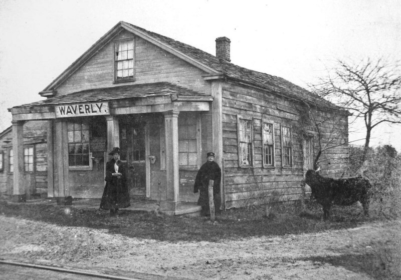 Waverly Station, Holtsville - Female Station Agent M. E. Bloomer - View SE c.1880 |
LINE OPENED IN 1843 BUT STOP NOT
(HOLTSVILLE) LISTED ON TIMETABLES OF 1844 AND 1845. BECAME STATION STOP:
__?__. Photo: Arthur W. Murray - Archive: Queens Public Library |
||||||||||||
| WESTBRIDGE STATION | |||||||||||||
| WESTBRIDGE: JAMAICA AVE. AT 130TH ST., JAMAICA. SHELTER SHED OPENED: 6/28/1916, WITH STREET-LEVEL TICKET OFFICE ON JAMAICA AVE. AT THE CROSSING OF THE LIRR'S TRACKS BY THE JAMAICA AVE. EL. (photo provenance below) AGENCY CLOSED: 19_?_. OUT OF SVC: 1/01/1939 AND DISCONTINUED AS STATION STOP. Research: Dave Keller | |||||||||||||
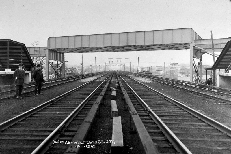 Westbridge Station - Construction of BRT Trestle - View W 12/11/1916 Archive: Dave Keller |
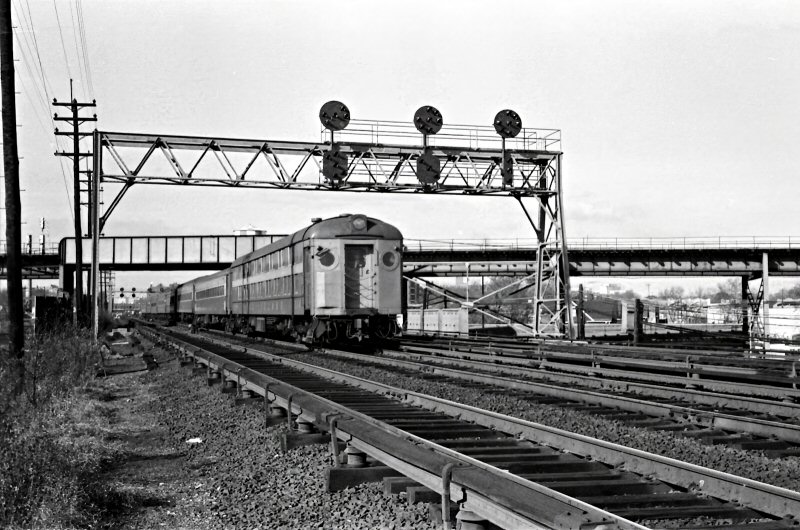 Former Westbridge Station eastbound MU on no.2 Track 11/24/1969 Photo/Archive: Richard F. Makse |
||||||||||||
| WINFIELD STATION | |||||||||||||
|
|
FLUSHING
& N. SIDE DEPOT BUILT: JULY/1854, MOVED TO WINFIELD JCT: 8/1876 |
||||||||||||
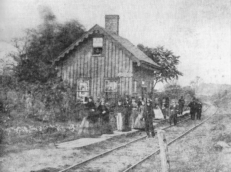
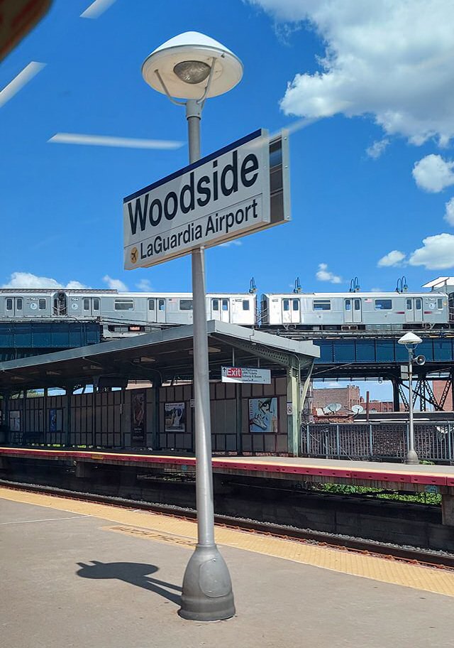
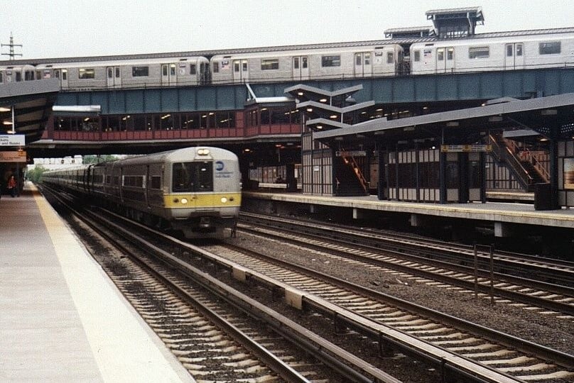
| WOODSIDE STATION | |||||||||||||
|
FLUSHING & N. SIDE DEPOT OPENED AT
TODAY'S 39TH AVE. BETWEEN 57TH & 58TH STS. ON OLD ALIGNMENT: 11/15/1869.
CLOSED: 1913 DUE TO GRADE ELIMINATION
2ND TEMPORARY STATION IN SVC. AT TODAY'S
60TH ST & WOODSIDE AVE. ON OLD ALIGNMENT DURING TRACK ELEVATION: 04/1913.
RAZED: 11/17/1915. |
|||||||||||||
|
|
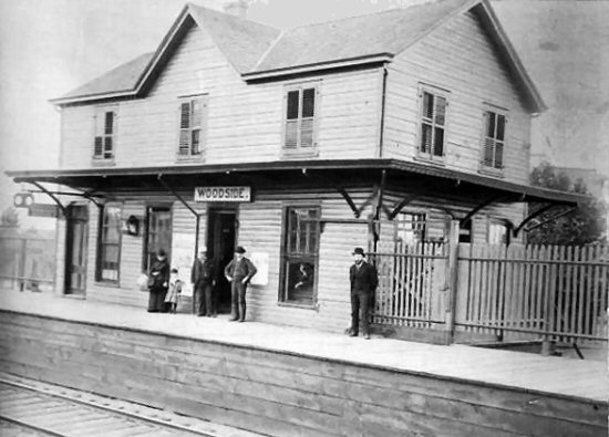 Second Woodside Station - 1880 Archive: Dave Keller |
 Woodside Station 1906 Archive: Dave Keller |
|||||||||||
|
|
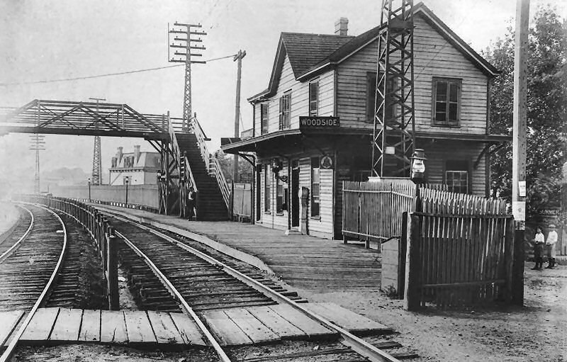
 Woodside Station View E c. 1913 Archive: Dave Keller |
 Woodside Station with EL c. 1918 View NW Archive: Dave Keller |
|||||||||||
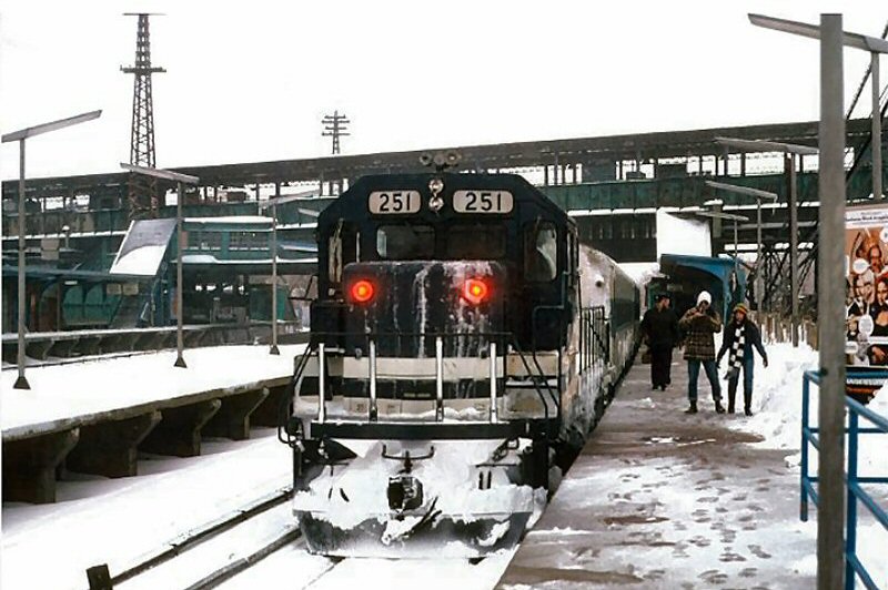
 LIRR C420 with passenger consist in tow passing the Bulova Building at Woodside Station on 8/27/1975 enroute to Jamaica. View SE Archive: L. McEnery
|
 Woodside Station at 61st St. and Roosevelt Avenue c.1918 Archive: Al Ponte
|
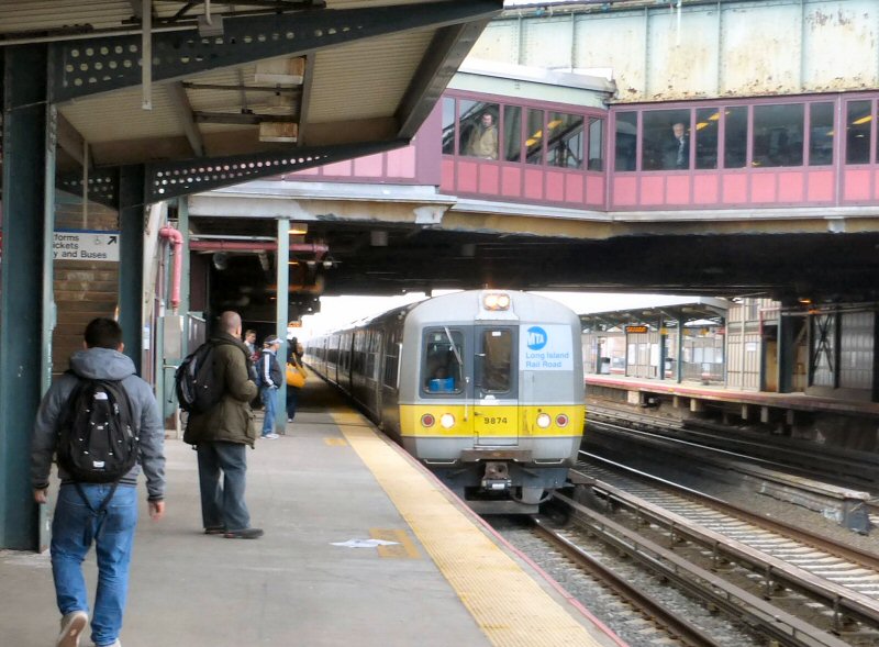
 LIRR GP38-2 pair #274-2xx at 61st St., Woodside View NW 5/1995 Photo/Archive: Bill Mangahas  MP15AC #172 at Woodside 5/26/2015 Photo/Archive: Kevin Wong |
|||||||||||
 Woodside 4/04/2022 Photos/Archive: Kurt Diesel 
|
|
 MPB-54 passing Woodside Station 11/19/1961 Photo: Eddie Davis, Sr. Archive: David Pirmann
|
|||||||||||
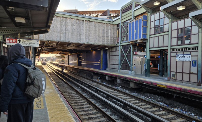
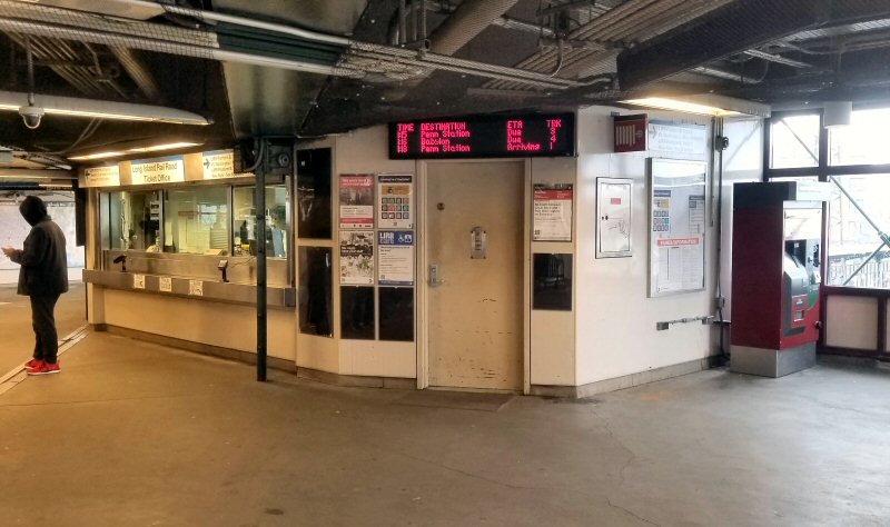
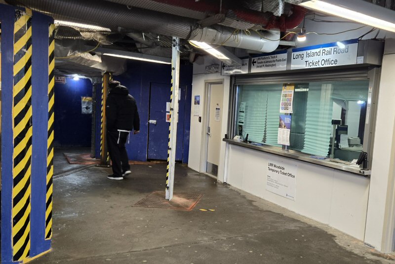 Woodside Station under construction 12/20/2025 - Temporary modular ticket office in service during the #7 Line subway construction through 2026 - 12/19/2025 Photos/Archive: Kevin Wong |
|||||||||||||


.JPG)

_MikePerlman.jpg)
.jpg)


%20-%201910-Keller.jpg)

.jpg)
.jpg)


